

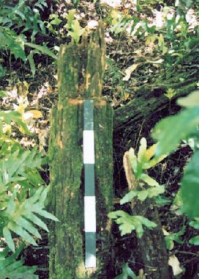
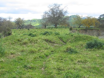
Te Aputa Pa is a well-preserved pa situated approximately 511m above sea level at the end of a narrow ridge overlooking the junction of the Mangakukeke Stream and Pourangaki River. Defences were recorded at each of the three vertices during a site visit by the Otaihape Field Group in 1965 and the remains of a ditch (approximately 8 metres wide) and bank are clealy visible today as you approach the pa from along the ridge. A rectangular pit and possible rua were also identified by the Otaihape Field Group and three carved posts were recorded. Two of the posts had narrowed necks and one was knotched. The ruins of five whare were also observed on the pa around 1896 by the landowner, C.G. Phyn. The dense vegetation coverage prevented a comprehensive survey of Te Aputa Pa during a recent site visit but the two carved posts and a kumara pit was located. Several other possible pit features were also noted. Evidence presented during the hearing of the Awarua Block at Wanganui in 1886 indicates that Te Aputa Pa was originally inhabited by descendents of Ngati Haukaha and was later occupied by Ngati Hauiti. It appears that Te Aputa Pa was built and occupied quite late in prehistory as Wi Wheko and fellow claimant Utiku Potaka spoke of their parents and grandparents living at the pa. Utiku Potaka was born in 1824 which would suggest that his parents and grandparents lived at Te Aputa Pa during the late 18th / early 19th centuries. Whilst Te Aputa Pa is of considerable cultural and traditional importance to Te Runanga o Ngati Hauiti, it is also a place of special significance to the family who own the land on which it is located. This family have been associated with Te Aputa Pa since the late 19th century and knowledge about the pa has been passed down through the successive generations. The family have a strong appreciation for the significance of Te Aputa Pa and are committed to the preservation of this site.
Location
List Entry Information
Overview
Detailed List Entry
Status
Listed
List Entry Status
Historic Place Category 2
Access
Private/No Public Access
List Number
7609
Date Entered
6th June 2005
Date of Effect
6th June 2005
City/District Council
Rangitīkei District
Region
Horizons (Manawatū-Whanganui) Region
Extent of List Entry
The registration includes the archaeological site of Te Aupata pa, defined as the entire flat at the end of the ridge (see Appendix 5 of Registration Report for sketch plan of site) located on Section 14, Block IX, Ruahine Survey District.
Legal description
Sec 14, Blk IX Ruahine SD (RT WN21D/616), Wellington Land District
Location Description
Te Aputa pa (T22/2) is located on a narrow ridge high above the junction of the Mangakukeke Stream and Pourangaki River (see Appendix 3 of Registration Report). It can only be accessed through the property of Cathy and Campbell Phyn, which is siutated on Mangakukeke Road (off Upper Kawhatu Road). Travel along the farm road by vehicle or on foot and then proceed across the farm paddocks in a westerly direction to the bottom of the ridge. The ascent to the pa involves a 15-20 minute climb through dense vegetation.
Stay up to date with Heritage this month
