

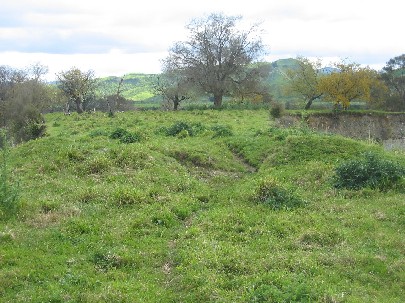
Okahupokia pā is located on a high and narrow ridge on the eastern bank of the Rangitīkei River near the Otara Bridge. It is strategically positioned so as to make use of the natural defences of the ridge to the north, south and east and to provide commanding views of the surrounding area. The western end of the pa features a double ditch and bank and there is a large flat area (c. 40m x 40m) just beyond that may have been utilised for gardening. Okahupokia pā was inhabited by the Ngāti Hauiti tūpuna Hauiti, and was described in the Māori Land Court evidence of Utiku Pōtaka, Rakura Hunia and Hana Hinemanu during the 1894 hearing of the Otamakapua No. 1 Block. Okahupokia pā and nearby sites such as Omanono pā and Korihirau pā are of cultural and traditional importance as they signify the presence of Ngāti Hauiti occupation throughout this landscape from prehistory to the current day. Okahupokia Pā was recently rediscovered by Te Rūnanga o Ngāti Hauiti after local historian Allen Shaw mentioned it at a school reunion. Shaw had been shown the site approximately 30 years prior and was able to point out the general vicinity of the site. Okahupokia pā is situated within farmland and is currently accessible by stock.
Location
List Entry Information
Overview
Detailed List Entry
Status
Listed
List Entry Status
Historic Place Category 2
Access
Private/No Public Access
List Number
7611
Date Entered
6th June 2005
Date of Effect
6th June 2005
City/District Council
Manawatū District
Region
Horizons (Manawatū-Whanganui) Region
Extent of List Entry
The registration includes the archaeological site of Okakupokia Pa (as shown in Appendix 5 of the Registration Report) with a buffer zone of 50 metres at the western end of the pa which includes the large flat (c. 40m x 40m) that would have been suitable for gardening, on Pt Lot 21, Deposited Plan 5866, Wellington Registry.
Legal description
Pt Lot 21 DP 5866 (RTs WN418/258, WNF1/18), Wellington Land District
Location Description
Okahupokia Pa is located on the eastern bank of the Rangitikei River, roughly 500 metres upstream from the Otara Bridge and is accessed via Otara Road through private land. The ditch and bank at the entrance to the pa is clearly visible from the flats below.
Stay up to date with Heritage this month
