

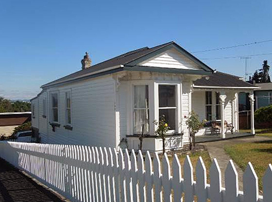
The house at 102 Forest Lake Road, Hamilton was constructed some time between July 1914 and 31 March 1917 as one of a group of state houses built under the Workers’ Dwellings Act 1910. The group of nine houses, all on the north-west side of Forest Lake Road, was named the Laurenson Settlement after Liberal Member of Parliament George Laurenson. It was the earliest state housing in Hamilton. The land on which the house was built was first surveyed in 1864 as land grants awarded to the Fourth Regiment of Waikato Militia after the conclusion of the Waikato Wars. It was part of 250 acres (101.25 hectares) awarded to surgeon John Carey of the 4th Waikato Regiment; he farmed the land, naming it Forest Lake after its area of native bush and the small lake, Rotokaeo. Subsequent owners John and Mary Walsh sold nine acres (3.6 hectares) to the Crown in 1912-13 as it was deemed suitable for housing the increasing number of workers associated with the railway activities at Frankton Junction close by. A strip of land on the north-western side of Forest Lake Road was subdivided into 36 lots with two of them designated as roads. The government architect, Woburn Temple, designed a range of workers’ dwellings for erection in several locations around the country. The house was built to Temple’s Design 5, a transitional villa with front bay window, a side cantilevered window and a verandah across part of the front. As well as the lean-to in the original design, the house appears to have had an additional lean-to built across part of the rear elevation, perhaps within 15 years of its construction. The second lean-to was modified twice, in the 1970s and c2010. Otherwise the house retains its original exterior appearance. A path that leads from the central front door to the gate at the corner of the property, typical of the front garden layout of the period, still remains. The house was owned from 1924 by James Kane of Frankton Junction, an engine driver. After his death, ownership transferred to Adrianus Everaarts of Hamilton, civil servant, and Neeltje Everaarts. They lived there for 30 years. In the 1990s, the property was subdivided into two parts and an additional house built at the rear. Its significance has led to its inclusion, with three other Laurenson Settlement houses, on the heritage schedule of Hamilton City Council’s Proposed District Plan. Forest Lake was part of the earliest growth of Hamilton/Frankton outside the original militia settlement of Hamilton West. The Laurenson Settlement initiated further spread to the north.
Location
List Entry Information
Overview
Detailed List Entry
Status
Listed
List Entry Status
Historic Place Category 2
Access
Private/No Public Access
List Number
9902
Date Entered
6th June 2014
Date of Effect
7th July 2014
City/District Council
Hamilton City
Region
Waikato Region
Extent of List Entry
Extent includes the land described as Lot 1 DPS 74198 (RT SA59C/999), South Auckland Land District and the building known as House (102 Forest Lake Road) thereon. (Refer to map in Appendix 1 of the registration report for further information.)
Legal description
Lot 1 DPS 74198 (RT SA59C/999), South Auckland Land District
Historic Significance
Historical Significance or Value The houses built as part of the Laurenson Settlement in Forest Lake Road are significant for their associations with government development of worker housing during the 1910s. It is the earliest group of state housing in Hamilton and provides a rare example of state housing from that period. Taken in conjunction with other state housing in Hamilton, the houses are significant in representing national trends in the development of workers’ housing in New Zealand from a range of periods. The Laurenson Settlement contributed to the spread of Hamilton and Frankton to the north, the development being one of the first in the Forest Lake area when the area was still part of rural Waipa County. It provided affordable housing for the growing population of Frankton, primarily for railway staff, factory workers and manual workers. The occupants of the houses were part of a growing community in Forest Lake and the adjacent Maeroa area who worked together to establish services and facilities such as a primary school, church and bus services, and to get the area recognised as part of Hamilton Borough.
Physical Significance
Architectural Significance or Value The house is representative of state houses designed for low-income workers by the government architect Woburn Temple in 1910. The house is of a different plan to the house already registered (84 Forest Lake Road, Reg. 4346) and another (126 Forest Lake Road) proposed for registration; the three together are a good representation of Woburn Temple’s designs. The house at 102 Forest Lake Road is a transitional villa. Transitional villas, built in the 1910s, were typically planned as villas but began to incorporate some elements of the bungalow style such as verandahs covered by an extension of the main roof supported on plain posts with simpler brackets instead of the elaborate decorative detail of late Victorian villas. Interior features are also plain, with flat battens on the board and batten ceilings and plain skirting boards. The house retains significant features from the time of its construction.
Detail Of Assessed Criteria
(a) The extent to which the place reflects important or representative aspects of New Zealand history This house has great historical significance as it was one of a group of state houses built under the Workers' Dwelling Act 1910, one of the early large-scale central government initiatives to provide affordable housing to low-income workers and their families. It was part of a wider package of social legislation passed by the Liberal Government (1893-1912). The house designs were allowed to be modified to allow for individual needs, within controlled limits. (b) The association of the place with events, persons, or ideas of importance in New Zealand history The house is part of the Laurenson Settlement, which is associated through its named after with George Laurenson, a Liberal Member of Parliament; and with egalitarian policies of providing affordable housing for all New Zealanders. (k) The extent to which the place forms part of a wider historical and cultural area The house is one of a group of state houses of recognisably similar designs that exist in a residential area that also includes examples of later state and private housing. Summary of Significance or Values The house at 102 Forest Lake Road, Hamilton, is one of the nine earliest state houses in Hamilton, a group known as the Laurenson Settlement and built by the government under the Workers’ Dwelllings Act 1910 to provide affordable houses for low-income workers.
Construction Professional
Biography
Architect Woburn Temple was the Department of Labour Staff Architect from 1907 until 1915/
Name
Temple, Woburn
Type
Architect
Construction Details
Finish Year
1917
Start Year
1914
Type
Original Construction
Description
Alterations to kitchen, installation of windows
Finish Year
1939
Start Year
1930
Type
Modification
Description
Addition of basement garage
Period
Unknown
Type
Addition
Description
Removal of wall between living room and bedroom, replaced with wide arch in partial wall
Period
1970s - 1990s
Type
Modification
Description
Alterations to bathrooms, new eastern wall and doors on second lean-to
Finish Year
2013
Start Year
2009
Type
Modification
Construction Materials
Wood, brick (chimneys), corrugated iron (roof)
The house at 102 Forest Lake Road, Hamilton was constructed some time between July 1914 and 31 March 1917 as one of a group of state houses built under the Workers’ Dwellings Act 1910. The group of nine houses, all on the north-west side of Forest Lake Road,, was named the Laurenson Settlement after Liberal Member of Parliament George Laurenson, who advocated for the passage of the Act through Parliament. The Settlement was the earliest state housing in Hamilton. Research to date has not established which was the first house built nor the order (by address) of construction. In 1905, the Liberal government (1890-1912) passed the Workers’ Dwellings Act, making it ‘the first central government in the Western world to build public housing for its citizens’. The Act paved the way for state housing, but proscriptive conditions meant it was only partially successful. These conditions were mitigated in part by the Government Advances to Workers’ Act 1906 and by July 1908, 94 workers’ dwellings had been erected in Auckland, Petone, Christchurch, Dunedin and Coromandel. Under the subsequent Workers’ Dwellings Act 1910, the government enacted to build dwellings for landless urban workers for a ₤10 deposit. In 1910, architect Woburn Temple was reported as designing residences for those who had applied for and obtained loans under the Advances to Settlers scheme. It was compulsory for applicants to accept one of the designs provided by the Department of Labour, but modifications were allowed and Temple ensured there was no incongruity of design or materials. The designs, which had two to six rooms, followed ‘the usual style of smaller domestic architecture of New Zealand’. Plans for eight of the 15 designs are known to exist. Woburn Temple was the Department of Labour Staff Architect from March 1907 until 1915. Prior to that, he was described as a ‘government officer’ when inspecting the erection of workers’ dwellings at Ellerslie in July 1906. He was gazetted as an architect in October 1907. In 1908, he controversially experimented with day labour instead of contract labour, and constructed two state houses in concrete instead of wood - experiments designed to compare costs. Little is known of Temple’s other work or his personal life. He and wife Eva had at least two sons, born in 1908 and 1912. Woburn Temple’s death and burial records have not been located. The Laurenson Settlement is on Part Allotments 75 and 76 Pukete Parish and was first surveyed in 1864 into 50-acre allotments as grants to militiamen of the Fourth Regiment of the Waikato Militia. Allotments 75 and 76 were part of the 250 acres (101.25 hectares) allotted to Doctor John Carey, surgeon to the militia. He acquired an additional 150 acres (60.75 hectares) and called his farm ‘Forest Lake’ after its area of native bush and a small lake, Rotokaeo. His land extended along both sides of Forest Lake Road and the northern and eastern parts were adjacent to the original Town of Hamilton West. After Carey’s death in 1889, the farm was owned by his daughter Margaret Kelly. By 1912, the subject area was owned by Mary Walsh, wife of John William Walsh, farmer and flaxmiller of Te Rapa. By that time, the town of Frankton had been established to the west of Hamilton and Forest Lake was in Waipa County, just outside the boundaries of Frankton and Hamilton. The North Island Main Trunk (NIMT) railway line ran along the west side of the Forest Lake property, then south through Frankton Junction. In 1908, the NIMT was open from Auckland to Wellington. With the eastern lines to Rotorua and the Bay of Plenty from Frankton Junction, the rail traffic was considerable. By 1911, Frankton’s population was over 1000 people and growing fast, with employment centred around the railway and associated trades and businesses. Forest Lake fitted the government’s criteria for providing housing for workers with lower incomes in areas adjacent to cheaper rural land. On 20 May 1912, the government announced the purchase of land at Forest Lake for the purposes of providing housing under the Workers’ Dwellings Act 1910, with ‘general satisfaction’ being expressed locally. The land was a roughly 3.6 hectare strip on the north-west side of Forest Lake Road. The land was surveyed in June 1912 and divided into 36 lots plus one street (Lake Street) which lay between Lot 22 and Lot 23. The official land transfer post-dated the announcement of the purchase, as the Walshes did not have Certificate of Title. Title was issued to Mary Walsh on 18 September 1913, for 9 acres 2 roods 23.3 perches (3.9 hectares) on plan DP 7943. Three weeks later, on 8 October 1913, title was transferred to His Majesty the King for the purposes of the Workers’ Dwellings Act for 9 acres 18.7 perches (3.69 hectares) being ‘Lots 1 to 11, 13 to 36 and Walsh Street’ on plan DP 7943 being portions of Allotments 75 and 76 Parish of Pukete. Walsh Street was Lot 12. It was later named Moore Street. Lake Street was proclaimed a public road on 18 July 1914 and later named Walsh Street. The lots were numbered from one at the north-eastern end to 36 at the railway end, and with the removal of Lot 12 as a street, provided 35 sections for housing. The house at 102 Forest Lake Road was on Lot 11, adjacent to Moore Street. The group of workers’ dwellings at Forest Lake was termed the Laurenson Settlement in recognition of Liberal Member of Parliament George Laurenson (1857-1913), a strong advocate for the Workers’ Dwellings Act during its passage through parliament. He represented the Lyttelton electorate from 1899 until his death in 1913, and was Minister of Labour, Customs and Marine in the McKenzie Administration of 1912. He supported the Labour Party’s stance during the Auckland Watersiders’ strike and in recognition of this, his funeral cortege included nearly 1000 members of the Waterside Workers’ Union. On 8 November 1913, it was reported that the Frankton Borough Council had agreed at its monthly meeting to supply electricity to the Laurenson Settlement ‘if the government would erect poles and mains for about 30 chains to the nearest house, on the condition that the cost would be refunded if the property came into the borough’. Also in 1913, another landowner subdivided a 29 hectare block bordering the south-eastern side of Forest Lake Road into 200 sections for residential development. On 3 February 1914, the Superintendent Workers’ Dwellings advertised in the Waikato Times for tenders to construct six dwellings, each builder to state how many of the six he could construct; the closing date for tenders was 21 February. The plans, specifications and conditions of contract were available for inspection at the office of the Inspector of Factories in Hamilton. The report by the Minister of Labour for the year ending 31 March 1914 states that 340 dwellings had been built or were under construction nationwide. The report also states that nine acres (3.6 hectares) had been bought at Frankton. Photographs in the report show houses in Christchurch, Wanganui and Greymouth in the same designs as those in the Laurenson Settlement. On 28 May 1914, the Labour Department announced that it had accepted tenders for the construction of nearly 60 workers’ dwellings under the scheme inaugurated by the then Minister of Labour, John A. Millar several years previously. According to a newspaper report, ‘under [the scheme] a worker may, by paying a small deposit and subsequent regular instalments, obtain a house built from a selected design. A series being available, slight modifications are made to meet individual tastes and necessities’. As well as six contracts for Frankton Junction, there were others for Gisborne, Patea, Masterton and Tolaga Bay. The first load of timber for the Laurenson Settlement houses was delivered in mid June 1914, and within three weeks the framework and roof of ‘what promises to be a picturesque villa’ had been erected and timber for three other houses was on the ground ready. In the year to 31 March 1915, weekly or other payments contracted for in the Laurenson Settlement were ₤70/15/9, but only ₤64/4/7 was received, that is, ₤6/11/2 was in arrears. Of the 172 buildings built and disposed of nationwide during 1914-15, six were at Frankton Junction and none were in course of erection. All were built for applicant-purchasers. The average weekly amounts payable by the purchasers for a four-roomed house with section was 12/10 (12 shillings and 10 pence), and for a five-roomed house and section 15/6. The 1915 report states that the area available for new dwellings at Frankton was 7¼ acres (2.9 hectares) – the reduction being the roads. In the 1916 departmental report on owners in arrears, someone (or more than one person) in Laurenson owed ₤19/10/ – this sum came under the category of ‘Dwellings transferred to new purchasers’ or ‘Efforts being made to find more suitable purchasers’. The houses were built to standard plans with some modifications and are likely to have had similar materials and fittings. In 1916, similar houses being built in Wellington were described in some detail: ‘In all details the houses are well finished. Plaster and beaver-boards, with rimu fixtures, make a room look well … . Windows and doors are of latest design, and in the living rooms the fireplaces are of the hearth-grate type. Linen cupboards are fitted for the housewife, and there is every convenience desired in the kitchen, scullery, and bath-room, including copper, tubs, and other sundries …. In the five-roomed houses, the occupier may have either one large living room and four bedrooms, or living room, sitting room and three bedrooms. The same choice is given in the four-roomed houses, but with one less bedroom. On the front of each house there is a wide verandah or porch, while bay windows further relieve any severity of style…’. From the departmental reports, it seems that six houses were built in the Laurenson Settlement by March 1915, none in the April 1915 - March 1916 year (although three were in course of erection), and three in the April 1916 - March 1917 year. None were under construction at 31 March 1917. The houses were built on Lots 1, 3, 4, 11, 13, 14, 22 and 23. At the end of March 1917, there were no payments in arrears for the Laurenson houses. The Forest Lake Road lots were sold off or dispersed under Warrants or Deferred Payment Leases from November 1917. None of the first 18 lots sold relate to the houses currently identified as Laurenson Settlement state houses. Research to date has not established the date of construction of 102 Forest Lake Road nor the name of the first occupier or owner. Fewer workers’ dwellings were erected nationwide in the 1916-17 year as building costs rose: the average cost for a four-room wooden dwelling from ₤360 to ₤460 and for a five-roomed one, ₤450 to ₤560. The Department of Labour inspected its houses throughout the country and found that most owners were taking pride in their homes, laying out gardens and planting trees and shrubs. By 31 March 1918, there were 647 workers’ dwellings (plus one built but destroyed by fire) in the country. The Housing Act 1919 replaced the Workers’ Dwellings Act, the main change being to raise the income threshold for applicants. Further houses were built, and the 1920 report of the Minister of Labour stated that for Hamilton, negotiations for 25 houses were in progress. Two more houses may have been built in Forest Lake Road under the provisions of the 1919 Act. Further subdivisions by the Walshes and other landowners provided more sections for housing and Forest Lake began to develop as a residential area. Frankton merged with Hamilton Borough in 1917, but this still did not include Forest Lake. By 1923, there were 150 school-age children in the locality, and in 1926, Forest Lake School opened. In October 1923, Forest Lake Road was described in a house for sale advertisement as ‘the coming residential portion of Frankton’. In August 1923, householders from Forest Lake and Maeroa (adjacent to the south and south-east) decided to form a ratepayers association. The duly formed Maeroa Settlers’ Association considered a proposal to raise a loan for road improvements, but decided it was time for the locality to merge with Hamilton Borough. A petition signed by over 100 residents was submitted to the Governor-General and in December 1923, the Hamilton Borough Council agreed to incorporate Maeroa and Forest Lake. However, this did not happen officially until 1925. As the population of the area rose, services such as sewers, drainage, water supply and bus transport were provided. Loan proposals for the provision of sewerage and water system were discussed in August 1925. In 1929, the Anglican community built a church hall. The suburb was close to the railway station and workshops; the railway house factory and mill; the bacon factory and the Frankton butter factory. Most of the residents were working class - in 1919 occupiers of the Laurenson Settlement included six railways employees, an engineer, a motor mechanic, a bacon-curer, a butter factory worker and an ironmonger. In 1930, six of the twelve listed occupants between the railway line and Mitcham Avenue worked in railways occupations; however, these were not all Laurenson Settlement houses. On 9 May 1924, a new title for Lot 11 was issued to James Kane of Frankton Junction, an engine driver. He was seized of fee simple at that date but a Warrant had been issued to him for the same land on 24 March 1924. As the 1922 street directory shows J. Kane, railway employee, as being at Te Rapa, Frankton Junction (there is no listing by street), it is possible he was resident at 102 Forest Lake Road prior to his obtaining title. In a 1930 directory, Kane is shown as being on the block between Lake Avenue [sic] (now Walsh Street) and Mitcham Avenue (Moore Street did not then exist). Similarly, in 1932 and 1934 directories, he is shown at number 51. In 1947, Kane was in number 49, presumably a re-numbering. In 1949, Moore Street is noted, with Kane in number 102, another re-numbering. In 1937, Mary Walsh subdivided the land on the north-east side of Walsh Avenue. The rear (north-east side) of these lots was the boundary between Waipa County and Hamilton Borough Council. More state housing was built on the south-east side of Forest Lake Road and also in Rimu, Hinau and Matai Streets after 1938. Private housing, in those side streets and further along Forest Lake Road, was interspersed amongst state houses as the government sold off the unused sections bought as part of the Laurenson Settlement. By 1950, the Crown still owned nine of the Laurenson Settlement sections. Laurenson Lots 6, 7, 8, 16, 25, 26, 30, 31, 34, and 36 were held under deferred payment licenses under the Reserves and Other Lands Disposal and Public Bodies Empowering Act 1924, and validated many years later. James Kane retained ownership until his death (possibly in 1954). On 23 July 1962 the title transferred to John Louis Kane of Frankton Junction (butcher) and Mary [Haha/Hale] of Ngaruawahia (married woman). On 10 September 1962, ownership transferred to Adrianus Everaarts of Hamilton, civil servant, and Neeltje Everaarts. After the latter died, ownership passed by transmission to Adrianus Everaarts on 16 September 1992. He transferred ownership on 17 March 1995 to David C. and Sierra C. Gallagher. The Gallaghers, in combination with neighbours B. and D.J. Homewood, had the property surveyed in June 1996 in preparation for its subdivision and part merger with Lot 10. New titles were issued: D.C. and S.C. Gallagher received title to Lot 1 DPS 74198 (reduced to 610 square metres) on 1 November 1996. On 30 January 1997, title transferred to Doreen Maree Stedman. Current owners G.H. Douglas and P.M. Jones acquired the property on 21 August 2009. The north-western ends of former Lots 10 and 11 were surveyed subsequently as one lot on DPS 82364, then reconfigured again (DPS 92208). The north-western end of the original Lot 11 is now 2 Moore Street with another house on that land. An easement of right to drain sewerage exists on the title. Lot 1 with the original state house is the very corner of Moore Street and Lot 2 has access to both Moore Street and Forest Lake Road. The current owners have made some alterations to the bathroom and installed a second bathroom in the former wash-house. They have also altered the north-east facing elevation of the wall on the rear lean-to, installing French doors and cladding the exterior with matching rusticated weatherboards. The house has been recognised as being of value by its inclusion in the Schedule of Heritage Items Appendix 2.3-II in the Hamilton City District Plan (Operative) and the Proposed District Plan. Other early state housing groups in Hamilton include the Frankton railway settlement (1923-29), Richmond (late 1930s) and Hayes Paddock (1939-45). The Laurenson Settlement was the earliest state housing in Hamilton.
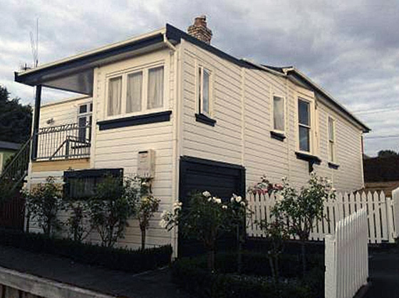
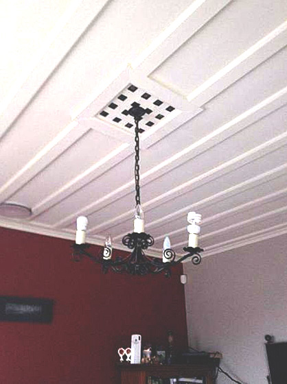
Builder: Public Works Department? Current Description The house is situated at the north-west corner of the junction of Forest Lake Road and Moore Street, in a residential suburb that contains state houses and privately-owned houses of different periods (from the mid 1910s onwards), a school, parks and a few shops. The front elevation faces south-east with the rear elevation facing north-west. The original ¼-acre (1011.7 square metre) section has been subdivided and an additional house built to the rear. Most other properties in this area of Forest Lake Road have also been subdivided and in-fill housing built. The house follows Design 5 (Public Works Department plan 54909), a six-roomed house, but has an additional lean-to across part of the rear elevation from the western end. This additional lean-to is shown on a November 1928 sketch plan drawn for the Hamilton Borough Council Sanitary Inspector’s office at the time of the drainage and sewer connection. Therefore it may have been part of the original structure. It had no drainage connections. The drainage sketch shows a toilet as a separate structure very close to the rear elevation, at its western end. This structure no longer exists. The house is a transitional villa with a bay window on the left-hand (western) end of the front elevation and a verandah on the remaining frontage. The hipped roof is of corrugated steel sheeting that extends over the verandah. An unusual decorative gable feature disguises the view of the horizontal ridge from the street. On the north-western side is a lean-to, with a partial lean-to onto that, that is, it does not continue along the length of the rear wall. The house sits on land sloping down at the rear and beneath the second lean-to is a basement garage with a modern steel door facing Moore Street. A vehicle inspection pit is recessed into the floor of the garage. A modern deck has been built onto the eastern end of the rear lean-to, with steps down to ground level. French doors open from the deck into a small room in the lean-to. The building is clad in rusticated weather-boards 170 millimetres wide. The wall below the gable and above the windows is clad in weatherboards with a scalloped lower edge to give the effect of wooden shingles. The windows are of the double-hung sash type. On the western side a pair of windows is cantilevered out from the wall, that is, they form a very shallow V-shaped bay (a feature of the original design). A brick chimney protrudes through the roof towards the north-west rear of the building, relating to the original kitchen. On the original plan this chimney is shown to service both a fireplace in the living room and a coal range in the kitchen. In the original design another double chimney serviced fireplaces in the corners of the front sitting room/bedroom and the western bedroom. This chimney and its fireplaces have been removed but its footing still exists. The house is 30 feet 4 inches (9.24 metres) across the front elevation, 31 feet 4 inches (9.54 metres) on the east elevation and 51 feet (15.54 metres) on the western elevation, taking into account the bay window and the lean-to. The plan shows two bedrooms and a bathroom on the eastern side, two living rooms and a bedroom on the western side, and a kitchen, scullery and washhouse at the rear. On the plan, the central hall gives access to the two front rooms then widens such that the bathroom is accessed from an alcove, out of sight from either the front or back doors. The living room opens into the end of the hall which then narrows to a passage that leads to the rear bedroom, kitchen, scullery and back door. The WC shown on the plan as under the roof of the lean-to, does not exist. Exterior deviations from the plan are evident in that the lean-to extends the full length of the rear wall, whereas the plan shows it to be recessed at each end. This deviation appears to be original. The ceilings in the main rooms are board and batten: the boards are approximately 0.25 metres wide and the battens, which are plain with a rectangular cross-section, approximately 0.1 metres wide. The cornices are similarly plain. The main rooms and hall have a 10-foot (3 metre) stud. Vents in ceilings above the electric light cords are of a rectangular lattice design. The bathroom ceiling is tongue-and-groove boards. The kitchen has been altered such that it incorporates the scullery and WC shown on the plan. A set of three casement windows with top lights in the rear elevation and a single window on the eastern side, are all c1930s in date. The Champion enamelled coal range remains in situ but the current owners have removed the wetback. There is a wooden (rimu) fire surround with mantel shelf and turned wood brackets (these may not be original as they differ in design). The bathroom has been modified by removal of the bath and replacement with a shower box. A second bathroom has been installed in the north-western corner of the lean-to, accessed from the kitchen. On the plan, this room is shown as the wash house with exterior access. This includes modifications to the cupboard and the sealing of a door that led from the second lean-to. The floor boards are 140 millimetre wide rimu. The skirting boards in main rooms and hall are 180 millimetres high with moulded profile. The architraves around doors and windows are similar in style, door architraves being 100 millimetres wide. The doors are solid wood with three panels – one across and two vertical. The front door is partly glazed with textured glass, plus there are three lights above and one narrow light in the wall each side; a panel each side is composed of tongue-and-groove boards set on the diagonal. The front door hardware is original. The fireplace in the living room has a plain wooden surround with mantel and shelf. The fireplaces in the south-western wall have been removed and the ceilings repaired in sympathy with the existing ceiling fabric. A decorative arch feature in the hallway still exists. The house is in good condition and retains most of its original features and fabric.
Completion Date
6th June 2014
Report Written By
Lynette Williams
Information Sources
Gibbons, 1977
P.J. Gibbons, Astride the River: A History of Hamilton, Christchurch, 1977
Schrader, 2005
Ben Schrader, We call it home: a history of New Zealand state housing. Auckland: Reed, 2005
Report Written By
A fully referenced registration report is available on request from the Lower Northern Area Office of Heritage New Zealand. Please note that entry on the New Zealand Heritage List/Rarangi Korero identifies only the heritage values of the property concerned, and should not be construed as advice on the state of the property, or as a comment of its soundness or safety, including in regard to earthquake risk, safety in the event of fire, or insanitary conditions.
Current Usages
Uses: Accommodation
Specific Usage: House
Related listings

Stay up to date with Heritage this month
