

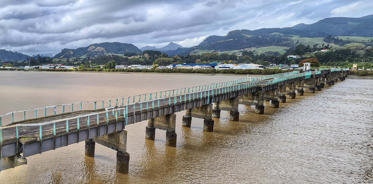
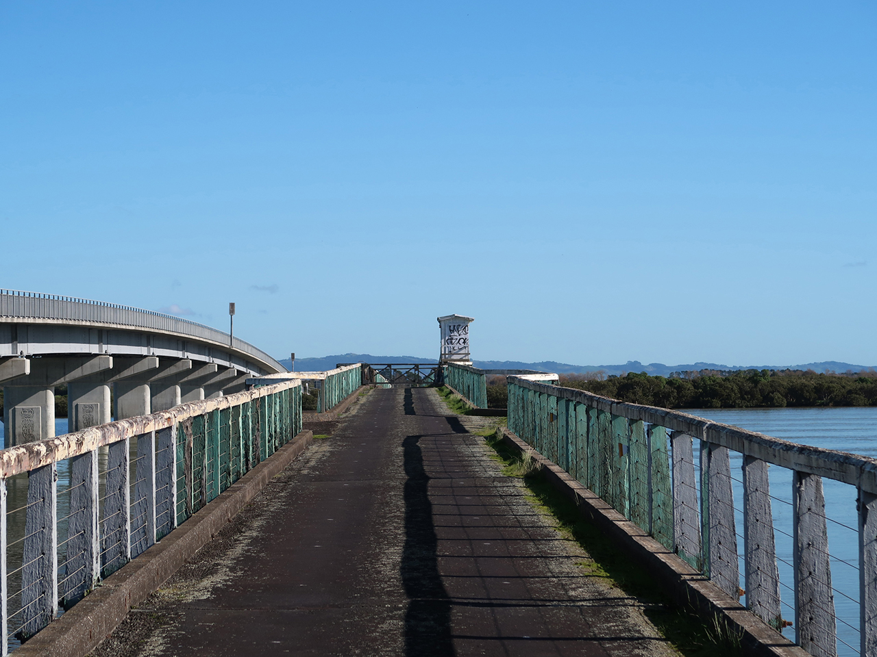
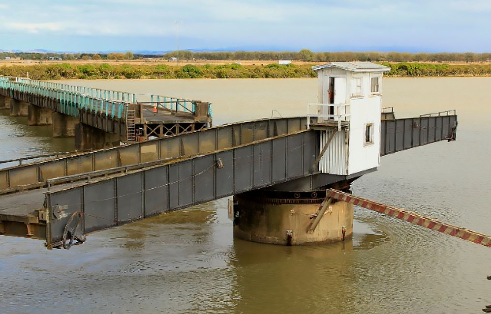
The bridge is an extensive 463 metre-long structure, which is mostly a single lane wide. It was designed by J. E. L. Cull, who had been the first design engineer employed by the Department of Public Works. The structure consists of 23 steel spans sitting on reinforced concrete piers. It has a central swinging span 42.7 m long, which turns on a central pier, providing boats with a clear width of 15.8 m between the fenders. The structure was technologically advanced, particularly in its use of deep piles to counteract a soft river bottom and strong tidal currents. A bridge master operated the electric swing mechanism, and was housed in a central cabin. Although a system of coloured lights was used to inform shipping about the opening of the swing span, early difficulties in boats adapting is evident from accidents in 1927 and 1928, when both the 'Tuhoe' and 'Taniwha' crashed into the bridge. As river transport declined, the bridge became more important for providing passage to the growing amount of long-distance road traffic between Auckland and the Coromandel peninsula. In the early 1990s it became the most heavily used single-lane road bridge in New Zealand, seeing 4,200 vehicles per day.
Kopu bridge is nationally significant as the only surviving road bridge of swing span type in the country. It makes a valuable contribution to the history of both motorised road transport and shipping, and is particularly significant for demonstrating early central government involvement in the development of highways. It marks the last stages in the history of major river transport on the Waihou, used by both Maori and Captain Cook. The bridge is important as a substantial technological achievement, occurring as New Zealand placed a greater emphasis on large-scale engineering projects in the 1920s. It demonstrates the political prestige placed in such works, being particularly linked with Gordon Coates and the development of the rural economy. The bridge was one of the most significant public projects carried out in the region, and is important for its connections with the expansion of farming and butter production. The bridge has had a long association with Thames and can be linked to the town's move away from its reliance on the mining industry. It is a distinctive part of the local landscape, and has educational value as a well-known and well-used historic structure on a major holiday route.
List Entry Information
Status
Listed
List Entry Status
Historic Place Category 1
Access
Private/No Public Access
List Number
4681
Date Entered
13th December 1990
Date of Effect
13th December 1990
City/District Council
Thames-Coromandel District,Hauraki District
Region
Waikato Region
Status
Listed
List Entry Status
Historic Place Category 1
Access
Private/No Public Access
List Number
4681
Date Entered
13th December 1990
Date of Effect
13th December 1990
City/District Council
Thames-Coromandel District,Hauraki District
Region
Waikato Region
Why is this place significant?
Historic Significance
Historical Significance or Value The Kopu Bridge was constructed as a result of the growing importance of road transport in the 1920s and in response to the development of the Hauraki Plains. It provided the river crossing for the main highway between Pokeno and Tauranga shortening the route between Auckland and the Thames-Coromandel Peninsula. Much of the structure's historical significance is derived from its design which made provision for the considerable river traffic which had begun in earnest in the 1880s and upon which the region initially depended to facilitate development.
Physical Significance
ARCHITECTURAL QUALITY: This light but permanent structure with its deep piled foundations and swing span was the design solution to the particular set of circumstances encountered - the considerable length needed to span the estuary at this point and the soft material which had to support foundations, the need to retain a navigable course for shipping on the river, and the financial constraints. The swing span no longer operates but is intact and the bridge itself is well maintained and largely unmodified. The Kopu Bridge continues to serve traffic using State Highway 25 more than sixty years after its opening. Its swing span gives the bridge a particular rarity. TOWNSCAPE/LANDMARK VALUE: The bridge is a long structure with low profile. Although on a state highway it is not highly visible to the travelling public.
Construction Professional
Name
Cull, John Ernest Lelliott
Type
Architect
Biography
Born in Christchurch in 1878, John Ernest Lelliott Cull studied at Canterbury University College before taking his degree in England. He began his professional career with Cutten Bros in 1898 in the field of dredge design. He was then a member of the staff of Canterbury University College (1902-06) and was frequently consulted by local bodies on engineering matters. He became assistant engineer to the Auckland Drainage Board and was involved with mining and local body work in that region. This was followed by a period as inspecting engineer to the Auckland Harbour Board. In 1914 he was employed by the Public Works Department. He was the department's first designing engineer and held this position until 1920, during which time he was responsible for the design of the Mohaka Viaduct. In 1929 he took up the chair of Civil Engineering at Canterbury University College, remaining there until his retirement in 1941. Professor Cull was Chairman of the Building Regional Committee set up following the 1931 Napier earthquake to draw up standards for earthquake resistant building in the affected area. This committee drafted standard specifications for buildings likely to be erected in earthquake prone areas. Cull served as president of the New Zealand Institution of Engineers. He died in 1943.
Name
Thornton, Onslow Garth
Type
Engineer
Biography
Onslow Garth Thornton (1890-1972) was born in Clive, Hawke's Bay, in 1890. He joined the Public Works Department at Wellington as a cadet in 1908. From the beginning of his career he was involved in surveys and construction of roads and railways, coastal protection and river control works. He held the position of Resident Engineer, Paeroa (1925-1929) during which time the construction of the Kopu Bridge was carried out under his control. Subsequently Thornton became the District Engineer at Gisborne, deputy District Engineer and later District Engineer in Auckland, and District Engineer and shortly before retiring after 42 years of service, District Commissioner of Works at Hamilton. After his retirement he was involved in arbitration and commissions of inquiry on civil engineering matters and later worked for the Auckland Regional Planning Authority. The electric beacon on Kawiti Point, the northernmost point of Kawau Island was renamed Thornton Light in his honour in 1963.
Construction Details
Type
Other
Description
Site of ferry crossing
Period
pre-1928
Start Year
1926
Finish Year
1928
Type
Original Construction
Description
Construction of Hauraki (now Kopu) Bridge
Start Year
1971
startYearCirca
Finish Year
1973
Type
Modification
Description
Alterations to bridge beside the rotary swing span
Type
Addition
Description
Addition of weatherboard structure at east end of bridge
Period
1960s or 1970s (circa)
Construction Materials
- Concrete piers on piled foundations; - Piers spanned by laterally braced plate girders surmounted by a reinforced concrete deck; - Bridgeman's operating cabin, timber frame with long-run steel cladding; - Shed (eastern end of bridge), timber frame with weatherboard cladding.
Notable Features
Registration covers the structure, its fixtures and finishes, including the bridge keeper's cabin and weatherboard structure adjoining the eastern end of the bridge. It also includes recent modifications. Swing span including bridge keeper's cabin and swing mechanism.
DESCRIPTION: The Kopu Bridge was formally opened by Prime Minister J.G. Coates, on 11 May 1928. Negotiations between the Public Works Department and local authorities had commenced in 1911 although a bridge had been mooted prior to this date. The nearest bridge was 22 miles upstream near Paeroa although ferries crossed the river at various points. In 1922 the Hauraki Plains County, Thames County and Thames Borough Councils agreed that between them they would find £30,000 towards the cost of the £52,000 bridge, the balance to be provided by the Government. The site chosen suited the trend of business and flow of traffic. The loading to which the structure was designed was the Public Works first class standard for traffic bridges. Navigation requirements for steamers such as the Taniwha of several hundred tons burden which plied the river called for a 50 foot wide opening. Twelve test piles were driven abreast of the site in 1924. At a ceremony two years later the first pile of the bridge was driven by the Minister of Works, K.S. Williams. The construction of the central swing span and the fabrication of the steel girders was carried out at the Public Works Department depot at Tauranga. Girders ready for erection were transported by scow around the coast and lifted straight onto the piers by the scow's winches. Material required for substantial earthworks for the bridge approaches was provided by suction dredge from the river bed itself. As a result of a gradual falling off of river traffic, the bridge keeper was not replaced when he retired in 1964. The swing span remained in use into the 1970s although is now no longer operated.
DESCRIPTION: The Kopu Bridge was formally opened by Prime Minister J.G. Coates, on 11 May 1928. Negotiations between the Public Works Department and local authorities had commenced in 1911 although a bridge had been mooted prior to this date. The nearest bridge was 22 miles upstream near Paeroa although ferries crossed the river at various points. In 1922 the Hauraki Plains County, Thames County and Thames Borough Councils agreed that between them they would find £30,000 towards the cost of the £52,000 bridge, the balance to be provided by the Government. The site chosen suited the trend of business and flow of traffic. The loading to which the structure was designed was the Public Works first class standard for traffic bridges. Navigation requirements for steamers such as the Taniwha of several hundred tons burden which plied the river called for a 50 foot wide opening. Twelve test piles were driven abreast of the site in 1924. At a ceremony two years later the first pile of the bridge was driven by the Minister of Works, K.S. Williams. The construction of the central swing span and the fabrication of the steel girders was carried out at the Public Works Department depot at Tauranga. Girders ready for erection were transported by scow around the coast and lifted straight onto the piers by the scow's winches. Material required for substantial earthworks for the bridge approaches was provided by suction dredge from the river bed itself. As a result of a gradual falling off of river traffic, the bridge keeper was not replaced when he retired in 1964. The swing span remained in use into the 1970s although is now no longer operated.
ARCHITECT/ENGINEER/DESIGNER: John Ernest Lelliot CULL (1879-1943) - Design Engineer, Public Works Department Onslow Garth THORNTON (1890-1972) - Supervising Engineer, Construction ARCHITECTURAL DESCRIPTION: The total length of the bridge is 463 metres made up of twenty-three 18.2 metre plate girder spans, with a central swing span of 42.6 metres. The electrically operated swing span turns on a concrete pier 6 metres in diameter and provides boats navigating the river with a clear width of 15.8 metres between the fenders. The swing span has not operated for many years. The central operating cabin is a modest corrugated iron shelter with two nine-light windows and a shallow pitched roof. The single-lane bridge is now regulated by traffic lights installed at its approaches in 1975. Eighteen of the bridge spans have a 3.6 metre wide roadway; five spans a 5.4 metre wide roadway. Handrails are Australian hardwood. The bridge deck is supported on piers, each pier consisting of two groups of composite piles (a timber leader with spliced concrete pile). The heads of each group of piles are enclosed in a cylindrical casing, the whole then surmounted by a dwarf reinforced concrete pier. Each group of piers under the 3.6 metre wide roadway spans consists of three piles while those under the 5.4 metre wide roadway spans consist of four piles. MODIFICATIONS: Prior to 1930 - Mattress of stone placed upon river bed around certain of the piers to provide resistance to movement of pile piers. Date unknown - Weatherboard "shed" adjoining eastern end of bridge, southern side of road shoulder.
ARCHITECT/ENGINEER/DESIGNER: John Ernest Lelliot CULL (1879-1943) - Design Engineer, Public Works Department Onslow Garth THORNTON (1890-1972) - Supervising Engineer, Construction ARCHITECTURAL DESCRIPTION: The total length of the bridge is 463 metres made up of twenty-three 18.2 metre plate girder spans, with a central swing span of 42.6 metres. The electrically operated swing span turns on a concrete pier 6 metres in diameter and provides boats navigating the river with a clear width of 15.8 metres between the fenders. The swing span has not operated for many years. The central operating cabin is a modest corrugated iron shelter with two nine-light windows and a shallow pitched roof. The single-lane bridge is now regulated by traffic lights installed at its approaches in 1975. Eighteen of the bridge spans have a 3.6 metre wide roadway; five spans a 5.4 metre wide roadway. Handrails are Australian hardwood. The bridge deck is supported on piers, each pier consisting of two groups of composite piles (a timber leader with spliced concrete pile). The heads of each group of piles are enclosed in a cylindrical casing, the whole then surmounted by a dwarf reinforced concrete pier. Each group of piers under the 3.6 metre wide roadway spans consists of three piles while those under the 5.4 metre wide roadway spans consist of four piles. MODIFICATIONS: Prior to 1930 - Mattress of stone placed upon river bed around certain of the piers to provide resistance to movement of pile piers. Date unknown - Weatherboard "shed" adjoining eastern end of bridge, southern side of road shoulder.
Historical and Associated Iwi / Hapū / Whānau
Completion Date
10th December 2001
Report Written By
Martin Jones
Information Sources
Appendices to the Journals of the House of Representatives (AJHR)
Appendices to the Journals of the House of Representatives
Auckland Public Libraries
Auckland Public Libraries
Auckland Weekly News
Auckland Weekly News
Cyclopedia of New Zealand, 1903
Cyclopedia Company, Industrial, descriptive, historical, biographical facts, figures, illustrations, Wellington, N.Z, 1897-1908, Vol. 3, Canterbury Provincial District, Christchurch, 1903
Furniss, 1972
C.A. Furniss, 'Waihou' - The River with a Past', Auckland Maritime Society: Voyage to Paeroa, 29-30 January 1972
New Zealand Herald
New Zealand Herald, 12 July 1932, p. 6; 28 September 1933, p. 6.
New Zealand Historic Places Trust (NZHPT)
New Zealand Historic Places Trust
Plans
Architectural Drawings/Plans
Thornton, 2001
Geoffrey Thornton, Bridging the Gap, Early Bridges in New Zealand 1830-1939, Auckland, 2001
New Zealand Society of Civic Engineers Inc (NZSOCE)
The New Zealand Society of Civic Engineers Inc.
Furniss, 1977
C Furniss, Servants of the North: Adventures on the Coastal Trade with the Northern Steam Ship Company, Wellington, 1977
Thornton, 1941
O G Thornton, Who's Who in New Zealand, Wellington, 1941
Other Information
This historic place was registered under the Historic Places Act 1980. This report includes the text from the original Building Classification Committee report considered by the NZHPT Board at the time of registration. Please note that entry on the New Zealand Heritage List/Rarangi Korero identifies only the heritage values of the property concerned, and should not be construed as advice on the state of the property, or as a comment of its soundness or safety, including in regard to earthquake risk, safety in the event of fire, or insanitary conditions.
Current Usages
Uses: Transport
Specific Usage: Bridge/ Viaduct
Web Links
description: Engineering NZ Heritage
url: https://www.engineeringnz.org/our-work/heritage/heritage-register/kopu-bridge/
Current Usages
Uses: Transport
Specific Usage: Bridge/ Viaduct
Web Links
description: Engineering NZ Heritage
url: https://www.engineeringnz.org/our-work/heritage/heritage-register/kopu-bridge/
Location
Stay up to date with Heritage this month
