

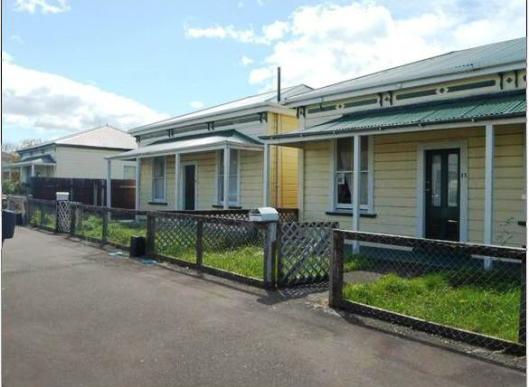
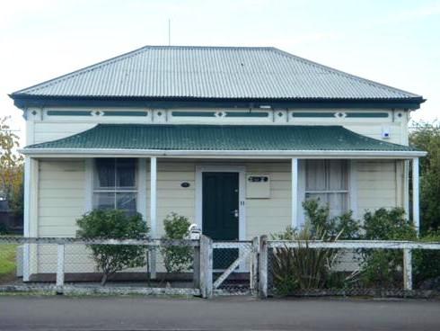
These three cottages at 11 - 17 Allardice Street, Dannevirke, form a historic area where formerly six cottages stood in a row along 9 – 19 Allardice Street. These cottages are representative examples of double-box cottages common in workers’ settlements at the turn of the century. Three have gradually been removed, one from the corner with Burns Street, one between 11 and 15, and more recently 19 Allardice Street was removed due to its dilapidated state. These cottages have been known as the Allardice Street Workers’ Cottages, and evidence suggests that the houses were present on the site in 1903, and that they were constructed for rental purposes by a local developer. Other cottages constructed at or around the same time remain in the adjoining Burns Street, giving the Allardice Street houses a historic context, and offering a hint of the time in which they were constructed. All three cottages follow a basic double box cottage form, with hipped-roofs. 11 Allardice Street has been extensively renovated on the interior, as it was converted into an office, then back into a residence with a kitchen and bathroom installed in 2010. 15 and 17 Allardice Street have had fewer renovations, and retain some of their historic fabric on the interior, including tongue and groove ceilings, cupboards and in the case of 17, a coal range. The kitchens and bathrooms have been renovated in both these houses. The exteriors, however, remain unchanged, forming part of their aesthetic value. In their current place the buildings have aesthetic value by forming a notable element of the streetscape, strengthened because as a group they have homogeneity of form. The cottages are architecturally representative of a type of standard house plan that was common in New Zealand at the turn of the twentieth century. Speculative buyers often bought a large number of sections at a time and built six or eight houses on these sections, providing rental houses for those who could not afford to buy or construct their own homes. Known colloquially as the ‘Ugly Sisters’, their simplicity and lack of ornamentation forms a physical link demonstrating the lives of early working-class settlers in Dannevirke, and early private property development. In their proximity to the main street of Dannevirke they also provide value in their possibility for public education through passers-by to the site.
Location
List Entry Information
Overview
Detailed List Entry
Status
Listed
List Entry Status
Historic Area
Access
Private/No Public Access
List Number
7025
Date Entered
11th November 1986
Date of Effect
11th November 1986
City/District Council
Tararua District
Region
Horizons (Manawatū-Whanganui) Region
Extent of List Entry
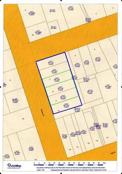
Extent includes the land described as Lot 1-2 DP 1127 (RT HB117/249); Lot 3 DP 1127 (RT HB125/54); Lot 4-6 DP 1127 (RT HBK3/1056, HBK3/1057, HBK3/1058), Hawkes Bay Land District and the remaining cottages: 11, 15, 17 Allardice Street, Dannevirke thereon, and their fittings and fixtures.
Legal description
Lot 1-2 DP 1127 (RT HB117/249); Lot 3 DP 1127 (RT HB125/54); Lot 4-6 DP 1127 (RT HBK3/1056, HBK3/1057, HBK3/1058), Hawkes Bay Land District
Status
Listed
List Entry Status
Historic Area
Access
Private/No Public Access
List Number
7025
Date Entered
11th November 1986
Date of Effect
11th November 1986
City/District Council
Tararua District
Region
Horizons (Manawatū-Whanganui) Region
Extent of List Entry
Extent includes the land described as Lot 1-2 DP 1127 (RT HB117/249); Lot 3 DP 1127 (RT HB125/54); Lot 4-6 DP 1127 (RT HBK3/1056, HBK3/1057, HBK3/1058), Hawkes Bay Land District and the remaining cottages: 11, 15, 17 Allardice Street, Dannevirke thereon, and their fittings and fixtures.
Legal description
Lot 1-2 DP 1127 (RT HB117/249); Lot 3 DP 1127 (RT HB125/54); Lot 4-6 DP 1127 (RT HBK3/1056, HBK3/1057, HBK3/1058), Hawkes Bay Land District
Historic Significance
Historical Significance or Value This place was registered under previous legislation. This current assessment was completed based on the criteria under section 23 (1) and (2) of the HPA 1993 but has not been approved by the Board as part of a formal review process. Historical Significance or Value The buildings possess historic value by offering insight into early life in Dannevirke. Their construction shows the growth in population in the town over time. This growth was advanced by the development of industries such as the railway in the early years of the towns’ expansion, and later industries such as sawmilling. The houses reflect the style, construction and form of the settlement of Dannevirke with their basic design. While state housing schemes under Seddon’s Workers’ Dwelling Act 1905 often made a concerted effort to avoid ‘monotony’ in a streetscape, the Allardice Street Workers’ Cottages demonstrate the type of private development that the Liberal Government’s housing scheme was trying to avoid replicating - ‘workers’ barracks’ associated with the risk of becoming slum neighbourhoods. As such, the houses also represent early private investment property development.
Physical Significance
This place was registered under previous legislation. This current assessment was completed based on the criteria under section 23 (1) and (2) of the HPA 1993 but has not been approved by the Board as part of a formal review process. Aesthetic Significance or Value In their current place the Allardice Street Workers’ Cottages offer aesthetic value by forming a prominent part of the streetscape, and as a group the houses have aesthetic value because of their homogeneity of form. Built to a similar design, the houses are almost identical in appearance which makes them a striking group. Their simplicity and lack of ornamentation forms a notable aesthetic that has led to them being known colloquially as the ‘Ugly Sisters,’ enhanced by the regularity in the size of the sites, which are small by modern standards, meaning that these houses sit closely together in a row. Architectural Significance or Value The cottages are representative of a type of house plan that was common in New Zealand at the turn of the twentieth century. These houses were planned for people of limited means and had provision for the addition of rooms as required. Built to a standard plan, the houses are almost identical in appearance which makes them a striking group. All three houses are of the double box cottage form, with hipped-roofs. Speculative buyers often bought a large number of sections at a time and built six or eight houses on these sections, providing rental houses for those who could not afford to buy or construct their own homes. As such, these houses represent the lives of the people who rented the houses through necessity, and also the development of investment housing built by local speculators. These houses also represent the type of housing that the 1905 Workers’ Dwelling Act was trying to avoid, which were associated with slum, overcrowded, housing. The relatively unaltered layout and fixtures of the houses offer suggestions of the lives of generations of low-income working-class residents.
Construction Details
Description
Cottages built prior to 1903
Period
1900
Start Year
1903
Type
Original Construction
Description
Numbers 9, 13 Allardice Street removed or demolished (date unknown)
Type
Other
Description
Number 19 Allardice Street removed
Start Year
1998
Type
Relocation
Description
Number 11 altered for conversion to office use
Start Year
2004
Type
Modification
Description
Number 11 reconverted to a house, new bathroom, kitchen and other fittings installed
Start Year
2010
Type
Modification
The discovery and settlement of the Wairarapa and Tararua regions is connected with several prominent figures of New Zealand’s history. Ancestral figures such as Hau-nui-a-nanaia, Kupe, Whatonga, Tara Ika and Toi have all been said to have connections with the region and are responsible for the naming of many of the Wairarapa’s features and places. It has been estimated that Rangitane settled in the region by about the sixteenth century. Marriage links with Rangitane saw a group of Ngati Kahungunu retreat to the Wairarapa in the subsequent century as the result of internal hapu conflict. The two groups cohabitated mostly in the south Wairarapa for a period, but then the Ngati Kahungunu newcomers negotiated several sections of land for themselves. This process was not seamless and instances of conflict continued between the two iwi over the centuries. The next significant period of change in the area was in the early nineteenth century with the progression south of Te Rauparaha and others. This ushered in an era when many different iwi, including Ngati Whatua, Ngati Awa, Ngati Toa, Ngati Raukawa, Ngati Tama, and Ngati Mutunga, made advances into the region and some Ngati Kahungunu hapu withdrew. The northern Wairarapa was heavily forested, as opposed to the south with its relatively clear and large grass plains. In particular the forest north of Mount Bruce was dense with rimu, tawa, matai, maire, kahikatea, and rata, and was known as Forty Mile Bush, which was within the larger Seventy Mile Bush, that also encompassed places such as Dannevirke and Norsewood. Maori referred to this forest as Te Tapere Nui o Whatonga (The great forest of Whatonga) and an abundance of birdlife resided there amongst giant ancient trees, some of which were large enough for groups of people to shelter within their trunks. Although it is estimated that the Maori population in the Wairarapa and Tararua regions was only about 1000 in the early nineteenth century, there seems to have been reasonable settlement around the Umutaoroa/Dannevirke region with at least five pa in the immediate area, some of which were fortified. These pa were characteristically located near waterways and there were also several small pa scattered along the Manawatu River in the Umutaoroa/Dannevirke area, which acted as outposts of the main Rangitane settlement of Te Reinga o Mahuru, in the ranges west of modern Dannevirke. European incursion into the Wairarapa only began after the New Zealand Company’s Port Nicholson settlement was established. Based on the reports of the exploring and surveying parties that the company sent out, the southern Wairarapa became one of the first extensive tracts of land to be occupied by Europeans, although the Crown titles, negotiated by Donald McLean, were not obtained until 1853. It took substantially longer for settlement to progress beyond Masterton, which was linked to Wellington by road in 1859. In preparation for the construction of the railway the government had an active role in the foundation of several places in the Wairarapa and southern Hawke’s Bay. Towns such as Eketahuna, Norsewood and Dannevirke were all initially formed as bases for the railway labourers and were settled mostly by Scandinavian immigrants. The Scandinavian (and German) migration to the Southern Wairarapa had been made possible through Julius Vogel’s (1835-1899) 1870 Immigration and Public Works Act. In 1871 the government began especially recruiting Scandinavians to come to New Zealand, because they were generally thought to have superior forest clearing skills and as having a greater tolerance to cold harsh climates. As such, Scandinavians were seen as particularly useful for work on the early phases of railway and road construction. In the two years after Norsewood and Dannevirke were established almost 800 Scandinavians came to the district. The growth of the town progressed steadily, particularly after the railway reached the town. While fires in the region were commonplace during the turn of the century, on Labour Day in 1917 there was a devastating fire in Dannevirke, described as a ‘holocaust,’ after which ‘practically nothing remained of the centre of the town.’ Similarly, there were several earthquakes felt in the region during its settlement, most pertinently the 1942 earthquake. The Allardice Street Workers’ Cottages survived these events. There is some speculation around when the cottages at 11-17 Allardice Street were constructed. The cottages have been known as the Allardice Street Workers’ Cottages, and it is somewhat unclear as to whether they were built in the 1920s under the provisions of the Workers Dwelling Act 1905 or were constructed earlier by a local developer. For example, after the building at 19 Allardice Street was removed from the site in 1998 it was claimed in The Dannevirke Evening News that in 1921 Dannevirke was ‘allocated the building of four cottages under the Workers Dwelling Act introduced by the Seddon government in 1904’ and that The Minister of Labour, Mr. G.T. Anderson, visited Dannevirke in March 1921 and stated the Allardice Street site was ‘very fine for the purpose’. The source material for these claims has not been able to be traced or confirmed, however. The Workers Dwellings Act was passed on 30 October 1905 by the Seddon Government in response to views on the housing requirements of workers at the time. The Act enabled the governor to set aside any Crown land or Land for Settlements land for workers' dwellings. This was borne from a growing concern at the time about the places in which workers lived, and sought to overcome the problems with overcrowding and the development of slums that earlier Acts, such as the Municipal Corporations Act 1900 had sought to alleviate. The Workers Dwellings Act is historically significant as the forerunner to the later development in 1937 of state housing in New Zealand. There is evidence to suggest that there were already buildings on the present site in 1903. Local newspaper, the Bush Advocate, reported in 1903 that: ‘There is a keen demand for properties in Dannevirke at the present time and several have changed hands at prices in favour of vendors. Amongst those which have been sold are a row of nine cottages in Allardice Street by Mr G. Wright to Mr Hollis (late of Kaianga, Palmerston N.)’ It appears that George Wright was not only a local property developer but also a successful baker, businessman and general entrepreneur, running a restaurant and boarding house in addition to his baking and catering business. It is not known exactly when he acquired the land, however title records suggest a possible construction date for the Burns Street cottages at least, resulting from a mortgage on the property in 1897. Wright died in 1905, and the land titles show that the formal transfer of Lots 1–7 and Lots 11-14 DP 1127, which includes 11, 15 and 17 Allardice Street, to Mr Charles Young Hollis of Palmerston North, Settler, was recorded on 13 February 1905. In 1906 the Bush Advocate advertised for sale ‘200 feet frontage to Allardice Street, close to High Street, with 6 cottages, and 115 feet frontage to Burns Street, with 3 cottages, all let and paying 10 per cent on price wanted; only £500 cash required.’ It appears from the Certificate of Titles, however, that Hollis did not sell the cottages at this time, and retained ownership of the land until the 1940s, and indeed in 1908 the Bush Advocate reported that Hollis had approved of a plan of ‘connecting his nine cottages with the sewer mains.’ The other three cottages mentioned in these reports were most likely those at 6-8 Burns Street, two of which remain today. In 1938 it was reported in the Evening Post that land purchases in Dannevirke would provide for the provision of state housing there, and by 1943, 51 houses had been built under the State Housing Scheme. Despite this, Keith Holyoake, at that time MP for Dannevirke, wrote to the Minister of Housing during the 1940s outlining the desperate need for housing in Dannevirke. This was particularly apparent at the time with troops returning from World War Two. There is no mention of cottages being built in Allardice Street at this time, despite other houses being erected for the State Housing Scheme, suggesting that these cottages were not built for this purpose at this time. Therefore there remains the question about whether these were constructed as part of the much earlier Workers Dwelling Act, or whether they are indeed the cottages that Hollis bought in or around 1903, and which were then rented by people with limited means (as such being ‘cottages for workers’, rather than specifically built as part of the Workers Dwelling Act). It seems unlikely that these houses were built as part of either Act, because evidence suggests that they were already on the site in 1905, and certainly there in 1921. Another possibility is that the houses were constructed for workers on the railway, for example, however this seems unlikely as there is currently no evidence of former Railways Department ownership to support this. All three houses are of the double box cottage form, with hipped-roofs. These are a type of house that was common in nineteenth century New Zealand, and were often built from standard plans. Arden and Bowman explain that in the late nineteenth century, speculative buyers often bought a ‘large number of sections, building six or eight houses simultaneously.’ While state housing schemes under Seddon’s Workers Dwelling Act 1905 often made a concerted effort to avoid ‘monotony’ in a streetscape - for example at the Heretaunga settlement in Petone (Record no. 7028), seven designs by prominent architects of the time were chosen and built at random along the street - the Allardice Street Workers’ Cottages demonstrate the type of private development that the Liberal Government’s housing scheme was trying to avoid replicating - ‘workers’ barracks’ associated with the risk of becoming slum neighbourhoods. The Allardice Street houses follow a basic cottage formula which is described in Brett’s Colonists’ Guide of 1883 as ‘a cottage suitable for a person with a small family and limited means. It can be built as a two-roomed cottage at first, and the two back rooms added subsequently whenever required.’ These houses had provision for a verandah to be added to the house at a later date if required, and as these three houses all feature similar verandahs it suggests they may have been added at the same time, if not when the houses were initially constructed. Architectural and historical evidence, therefore, suggests that these buildings were possibly constructed around the turn of the twentieth century, although it is also possible that the houses were built at a later time to an earlier plan. The evidence also suggests that they were built at the same time as each other, to a similar plan because they were being constructed for the purposes of being rental housing. While it is possible the occupants of these houses had notable or unusual histories, little evidence about these people is currently available. New Zealand street directories for Dannevirke simply listed the town’s inhabitants until 1911. At that time, when the directory listings became arranged by street, there are four occupants listed between Burns Street and High Street: a carter, a labourer, a bootmaker and a painter, further suggesting that the Allardice Street cottages were used by people of limited means. The houses speak of the development and growth of population in Dannevirke over time, however, and the requirement for the provision of rental houses. The houses also have potential to tell of the daily lives of the occupants and 17 Allardice Street has particular integrity in its original physical fabric, including a Shacklock ‘Orion’ coal range in the kitchen. Since their construction the houses at 15-19 Allardice Street have always been owned as a group, with 11 and former 13 Allardice Street also being parcelled off together for a time (1947-2007), but at present all of the properties are again owned by a single owner, echoing the collective association that was their history until 1947. As such, the houses are also representative of early private investment property development. A rudimentary assessment of buildings in Dannevirke suggests that this form of building was relatively common, and there are examples of other houses built to a very similar plan and appearance (including the same decorative frieze) in streets near Allardice Street, some of which are have been very well-maintained, while others are in a state of disrepair. The slightly run-down appearance of the Allardice Street cottages has led to their being colloquially known by Dannevirke locals as the ‘Ugly Sisters’. Given that six cottages were advertised for sale in 1906, and there are six lots of the same size in the street, it is possible to conclude that there were very likely once six cottages in a row along 9 - 19 Allardice Street. Comparison with an archive photo from 1921 also shows that there is apparently no space at the corner of the street as there is at present. If this is the case, one house has been removed from the corner of Allardice and Burns Street, and the cottage between 11 and 15 has also been removed. Certainly, in 1998, 19 Allardice Street was relocated due to its dilapidated state. In 1986 the houses at 15 - 19 Allardice Street entered in to a cross lease between the buildings. This allowed for the small space between the buildings to be acceptable under current property standard regulations. 11 Allardice Street has been extensively renovated on the interior, as it was converted into an office, then back into a residence with a kitchen and bathroom installed in 2010.
Exterior and surrounding area Although Allardice Street adjoins Dannevirke’s main shopping street and highway, the area surrounding the cottages is residential, with a historic shop on the corner of Allardice Street and High Street. This is adjoined by a corrugated iron warehouse which is in a state of disrepair. All the cottages have a large section to the rear which backs on to the Mangapurupuru Creek which runs along the back of the properties, and is visible when approaching from High Street. Continuing along Allardice Street there is a space to the side of 17 where number 19 was located before being removed. There is a small amount of refuse associated with this, brick footprints of the building remain in place, as does the concrete pad for the path to the house. There is only a small space between 15 and 17 Allardice Street, and all buildings are set reasonably close to the footpath. The properties of numbers 15 and 17 are separated by a lattice fence, while chicken wire makes up the remainder of the fence at the front of the buildings. There is a space between 15 and 11 where another house has been removed or demolished, which is now included in the land parcel surrounding Number 11. This house is separated from the other two properties by a high modern fence and also includes the corner property. This corner property would have been the site of the sixth cottage, and again this cottage has been demolished or removed. All three houses are of the double box cottage form, with hipped-roofs. 17 and 11 have lean-tos on the rear of the houses, while there is no such addition to number 15. All houses have matching sash windows in the front façade, and their verandahs also match. The verandahs on all have slight concave curves in the corner edges, of the ‘ogee’ type. Above these verandahs is a small amount of decorative adornment, in the form of a frieze with a central diamond with moulding carved to accentuate this. There are also double brackets surrounding the diamond, which is unusual as brackets are not normally in pairs such as these. This is the only adornment on the houses. Of the three, 11 Allardice Street is currently in the best state of repair, having only recently been re-converted from an office to a flat. In their setting the matching houses make a notable addition to the streetscape. All the houses are single storey, and are modest dwellings that directly adjoin the street, presenting an area which is evidently historic to passers-by. In the adjoining Burns Street, there are a further two similar cottages which add to the sense of a historic precinct. Interior Both 15 and 17 are built to a similar formula, with bedrooms along the northeast wall, one lounge and a kitchen adjoining the lounge at the rear. The lounge is entered from the front verandah with the bedrooms on the left. Number 11 is similar to this, however the bedrooms are instead along the southwest wall. Land included in the Registration The land included in registration is comprised of the house sites located between the corner of Burns Street and Allardice Street, and the right of way that extends past the edge of Number 19 Allardice Street. Historic Places on Land included in the Registration The Historic Places within the Registration are the three remaining houses, including outbuildings. The three houses are: 11 Allardice Street, Appendix 5, page 43 15 Allardice Street, Appendix 5, page 44 17 Allardice Street, Appendix 5, page 45 Relationship between Historic Places It seems likely that these houses were constructed for the same purpose at the same time, and certainly to a similar plan, meaning that there is a close relationship between these three houses. Visually, the houses are almost identical meaning that they have a strong aesthetic value due to their homogeneity of form. Presently two of the properties share a cross-lease title arrangement. Key Elements of the Historic Area The three houses remaining in this Historic Area form a closely spaced row, with the similarity in form of the houses meaning they make an impressive element of the streetscape. Not included in the area of registration are also two similar cottages in adjoining Burns Street, which add to the general feeling of the area being a historic precinct. There is also regularity in the size of the Allardice Street sites, which are small when compared with ordinary residential sections, meaning that in modern times the owners of 15 and 17 Allardice Street have entered into a cross lease allowed for the small space between the buildings to be acceptable. All the houses are single storey, and are modest dwellings that directly adjoin the street, presenting an area which is evidently historic to passers-by. Construction Materials: Timber, brick, glass, corrugated iron
Information Sources
Bagnall, 1976
A. G. Bagnall, Wairarapa; An Historical Excursion, Trentham, 1976
McLintock, 1966
An Encyclopedia of New Zealand, Government Printer, Wellington, 1966
Salmond, 1986
Jeremy Salmond, Old New Zealand Houses 1800-1940, Auckland, 1986, Reed Methuen
Shaw, 1997 (2003)
Peter Shaw, A History of New Zealand Architecture, Auckland, 1997
Arden, 2004
The New Zealand Period House: A Conservation Guide, Auckland, 2004.
Burr, 1995
V.A Burr, Mosquitoes and Sawdust: A history of Scandinavians in early Palmerston North and surrounding districts, Palmerston North, 1995
Schrader, 2005
Ben Schrader, We call it home: a history of New Zealand state housing. Auckland: Reed, 2005
Report Written By
A fully referenced version of this report is available from the NZHPT Central Region office Please note that entry on the New Zealand Heritage List/Rarangi Korero identifies only the heritage values of the property concerned, and should not be construed as advice on the state of the property, or as a comment of its soundness or safety, including in regard to earthquake risk, safety in the event of fire, or insanitary conditions.
Current Usages
Uses: Accommodation
Specific Usage: House
Former Usages
General Usage:: Accommodation
Specific Usage: House
Stay up to date with Heritage this month
