

List Entry Information
Status
Listed
List Entry Status
Historic Area
Access
Able to Visit
List Number
7386
Date Entered
24th April 1997
Date of Effect
24th April 1997
City/District Council
Auckland Council
Region
Auckland Council
Extent of List Entry
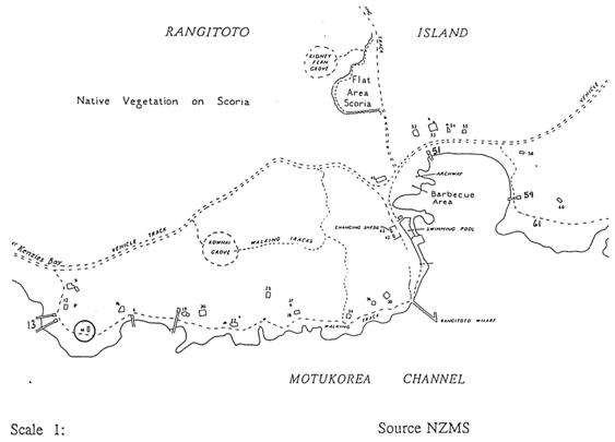
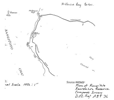
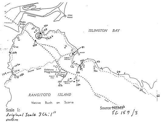
The area consists of 25 items located at the Rangitoto Wharf Settlement on the south side of Rangitoto Island facing Motukorea Channel. The axis of the area runs west to east and is bounded by a bach in the west, and by the Wharf Bay Coastal Path in the east. The northern boundary of the area is marked by the vehicle track to McKenzies Bay and by baches 52-55, and the southern boundary by the coast of the Rangitoto Wharf Settlement The area includes baches, boatsheds, and a slipway. (These items are numbered by the Trust 11-61 from west to east, with bach number 11 marking the western boundary of the area, and the coastal path, as noted above, the eastern boundary. The numbers allocated to the baches by the Department of Conservation on their maps, are the same numbers which the Trust has used. Please refer to the attached map which shows the locations of the 25 items in the area, and a key to the map with photographs taken by the Trust which correspond with the numbers which appear in the key.)
Status
Listed
List Entry Status
Historic Area
Access
Able to Visit
List Number
7386
Date Entered
24th April 1997
Date of Effect
24th April 1997
City/District Council
Auckland Council
Region
Auckland Council
Extent of List Entry
The area consists of 25 items located at the Rangitoto Wharf Settlement on the south side of Rangitoto Island facing Motukorea Channel. The axis of the area runs west to east and is bounded by a bach in the west, and by the Wharf Bay Coastal Path in the east. The northern boundary of the area is marked by the vehicle track to McKenzies Bay and by baches 52-55, and the southern boundary by the coast of the Rangitoto Wharf Settlement The area includes baches, boatsheds, and a slipway. (These items are numbered by the Trust 11-61 from west to east, with bach number 11 marking the western boundary of the area, and the coastal path, as noted above, the eastern boundary. The numbers allocated to the baches by the Department of Conservation on their maps, are the same numbers which the Trust has used. Please refer to the attached map which shows the locations of the 25 items in the area, and a key to the map with photographs taken by the Trust which correspond with the numbers which appear in the key.)
Why is this place significant?
Cultural Significance
This historic area was registered under the Historic Places Act 1993. The following text is from the original Historic Area Assessment Under Section 23 Criteria report considered by the NZHPT Board at the time of registration. Cultural: This value concerns the way this historic area demonstrates and represents the continuity and distinctive characteristics of a particular type of community in New Zealand - the seasonal holiday community of the coast. The beach and the bach are also associated with wider literary and cultural ideas. The beach, for example, has a symbolic value as an arena of historic change, as a meeting place of the races, and a place where natural and direct human values can be expressed. The Rangitoto Baches share something of wider values and ideas, and contribute something valuable to the cultural landscape of New Zealand. Social: Social and cultural values are related here. As in other communities of baches (Taylor's Mistake near Christchurch, for example), these structures were almost all used as holiday homes by Auckland families who spent part of their summers here. Most bach-owning families were probably (as their southern counterparts) lower middle-class or skilled working people from the Auckland suburbs. They made use of the small surplus income such families enjoyed during the 1920s (and to some extent, the (1930s) to build these simple cottages, and to enjoy the sort of physical freedom that had previously been more difficult to access by people of their walk of life.
Historic Significance
Historical Significance or Value This historic area was registered under the Historic Places Act 1993. The following text is from the original Historic Area Assessment Under Section 23 Criteria report considered by the NZHPT Board at the time of registration. Historical: The Historic Places Act 1993 requires an historic area to meet three criteria: (a) Contains an inter-related group of historic places: The exhaustive report The Rangitoto Baches: an Architectural and Historical Appraisal (Treadwell Associates, January 1993) documents the history of the Rangitoto baches very thoroughly. It shows that they were built over a very short space of time, albeit on an ad hoc basis and in eclectic styles, and aided by the Rangitoto Domain Board's mis-interpretation of the Domain Act 1881. It also explains that since the late 1930s they have shared a common threat, that of demolition by public authorities. That threat, coupled to location on an island, may have helped to form a sense of community amongst bach owners, who formed 'an effective corporate body gaining co-operation, labour and materials, not only from the Prison Department, but later from the Auckland Harbour Board and the Post Office'. (b) Forms part of the historical and cultural heritage of New Zealand: In recent decades New Zealanders have shown a greater appreciation of the contribution made to the New Zealand lifestyle by the bach or crib. A growing emphasis on social history, coupled with the work of photographers such as Robin Morrison (The South Island From the Road etc) and writers such as Paul Thomson (The Bach) and Keri Hulme (who writes from cribs in Moeraki and Okarito) have inspired several television programmes and exhibitions on the subject. The bach has even been raised to the status of a cultural artefact as a major permanent display in Auckland's new New Zealand National Maritime Museum. That significance owes much to the rise of the urban middle class during the 20th century. In his monograph on Otago Harbour's ferries, for example, F. H. McCluskie noted that crib owing became popular in the early 20th century when the creation of a modest affluence, increased leisure time, improved public and private transport all fed the urge to own a simple seaside retreat. Those utilitarian structures have come under threat in recent decades for a number of reasons: - population density increased to the point where public authorities began to prohibit new construction and even to order the removal of existing baches - the affluent became sufficiently affluent to either holiday overseas or to build more substantial seaside resort homes in seaside subdivisions. - work pressure and changing attitudes to work have reduced the recently-held belief in the sanctity of the weekend. Treadwell Associates' substantial 1993 architectural and historical appraisal of the Rangitoto baches establishes convincingly that the baches on Rangitoto Island form part of this distinctive cultural heritage background. Owners built baches on Rangitoto from the 1920s until 1937 when the government ordered their removal from what was a public reserve. Typically, owners protested and were granted a 'sinking lid'-style stay of execution. In 1953 owners were awarded lifetime leases with no right of transfer or compensation. By 1933, 33 remained of the 140 leases existing in 1957. The debate over the survival of the baches has, therefore, run for most of their existence. In addition to the themes of leisure, lifestyle and recreation noted above, it also illustrates a theme more recently identified within the heritage sector, that of the tension between the conservation of natural heritage and human heritage. (c) Lies within the territorial limits of New Zealand: Established.
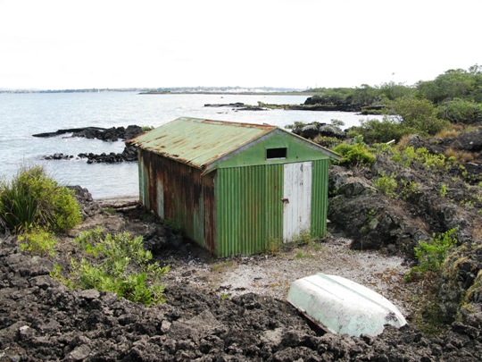
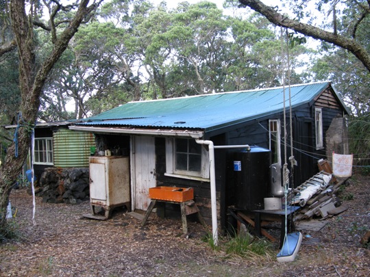
Physical Significance
This historic area was registered under the Historic Places Act 1993. The following text is from the original Historic Area Assessment Under Section 23 Criteria report considered by the NZHPT Board at the time of registration. Aesthetic: The baches, taken as a whole, realise the typical sensory and aesthetic values associated with seasonal coastal lif. The settlement here has been achieved with a minimum of artifice and design in the built form. Transience and impermanence are recognised in makeshift adaptations and use of materials to hand. The building landscape relationship is implicit and simple, with prominent gables being aligned to the water's edge. Architectural: There are 40 baches on Rangitoto Island in three distinct locations on the shoreline. The two major settlement areas are the Rangitoto Wharf Settlement (20 baches) and the Islington Bay Settlement (17 baches). There is a much smaller cluster at McKenzies Bay (3 batches). Some of the baches have associated structures in the form of boatsheds and slipways. This is an exceptionally detailed nomination. The appraisal and appendices by Treadwell and Associates provide an exemplary level of detail and amplify all the main points raised here. There seems little doubt that this collection of baches, taken as a whole, is a valuable resource, illustrating an important generic type of building and an underlying building-landscape relationship that is very much part of the New Zealand tradition. Baches are now regarded as a distinctive sub-group of New Zealand architecture. The nominator makes the point that the baches that remain on Rangitoto Island have a distinct and readily identifiable architectural character and survive today as a discrete collection of buildings. Since 1937, no new building has been permitted on the island, and additions to the baches have been closely controlled. Hence, the baches remain isolated in time as well as in place. The architectural character of the baches is most obviously expressed through the gable roof and its orientation with the water's edge. Typically, the Rangitoto baches are the size of a small suburban cottage, with an average frontage of about 8 meters. They are characterised by: - a shallow pitch of roof - a siting close to the ground - a disparity of scale between joinery items and whole buildings - aspects of the bungalow style - shallow-pitched roofs with exposed rafters and lined soffits, modest overhangs - open sleeping porches - boxed comers (I 920s); mitred or soaked corners (l930s) - extensive use of 6" bevel-back weatherboards - small bay windows - predominant use of casement windows - lean-to additions - prominent gable roofs (with ridges aligned to the water's edge) - timber framing; galvanised corrugated steel sheet roofs. The Rangitoto Baches, An Architectural and Historical Appraisal by Treadwell Associates, details individual features of these baches and their associated structures including boat sheds and slipways, gardens, siting, adaptations and improvisation, materials and building techniques.
Why is this place significant?
Cultural Significance
This historic area was registered under the Historic Places Act 1993. The following text is from the original Historic Area Assessment Under Section 23 Criteria report considered by the NZHPT Board at the time of registration. Cultural: This value concerns the way this historic area demonstrates and represents the continuity and distinctive characteristics of a particular type of community in New Zealand - the seasonal holiday community of the coast. The beach and the bach are also associated with wider literary and cultural ideas. The beach, for example, has a symbolic value as an arena of historic change, as a meeting place of the races, and a place where natural and direct human values can be expressed. The Rangitoto Baches share something of wider values and ideas, and contribute something valuable to the cultural landscape of New Zealand. Social: Social and cultural values are related here. As in other communities of baches (Taylor's Mistake near Christchurch, for example), these structures were almost all used as holiday homes by Auckland families who spent part of their summers here. Most bach-owning families were probably (as their southern counterparts) lower middle-class or skilled working people from the Auckland suburbs. They made use of the small surplus income such families enjoyed during the 1920s (and to some extent, the (1930s) to build these simple cottages, and to enjoy the sort of physical freedom that had previously been more difficult to access by people of their walk of life.
Historic Significance
Historical Significance or Value This historic area was registered under the Historic Places Act 1993. The following text is from the original Historic Area Assessment Under Section 23 Criteria report considered by the NZHPT Board at the time of registration. Historical: The Historic Places Act 1993 requires an historic area to meet three criteria: (a) Contains an inter-related group of historic places: The exhaustive report The Rangitoto Baches: an Architectural and Historical Appraisal (Treadwell Associates, January 1993) documents the history of the Rangitoto baches very thoroughly. It shows that they were built over a very short space of time, albeit on an ad hoc basis and in eclectic styles, and aided by the Rangitoto Domain Board's mis-interpretation of the Domain Act 1881. It also explains that since the late 1930s they have shared a common threat, that of demolition by public authorities. That threat, coupled to location on an island, may have helped to form a sense of community amongst bach owners, who formed 'an effective corporate body gaining co-operation, labour and materials, not only from the Prison Department, but later from the Auckland Harbour Board and the Post Office'. (b) Forms part of the historical and cultural heritage of New Zealand: In recent decades New Zealanders have shown a greater appreciation of the contribution made to the New Zealand lifestyle by the bach or crib. A growing emphasis on social history, coupled with the work of photographers such as Robin Morrison (The South Island From the Road etc) and writers such as Paul Thomson (The Bach) and Keri Hulme (who writes from cribs in Moeraki and Okarito) have inspired several television programmes and exhibitions on the subject. The bach has even been raised to the status of a cultural artefact as a major permanent display in Auckland's new New Zealand National Maritime Museum. That significance owes much to the rise of the urban middle class during the 20th century. In his monograph on Otago Harbour's ferries, for example, F. H. McCluskie noted that crib owing became popular in the early 20th century when the creation of a modest affluence, increased leisure time, improved public and private transport all fed the urge to own a simple seaside retreat. Those utilitarian structures have come under threat in recent decades for a number of reasons: - population density increased to the point where public authorities began to prohibit new construction and even to order the removal of existing baches - the affluent became sufficiently affluent to either holiday overseas or to build more substantial seaside resort homes in seaside subdivisions. - work pressure and changing attitudes to work have reduced the recently-held belief in the sanctity of the weekend. Treadwell Associates' substantial 1993 architectural and historical appraisal of the Rangitoto baches establishes convincingly that the baches on Rangitoto Island form part of this distinctive cultural heritage background. Owners built baches on Rangitoto from the 1920s until 1937 when the government ordered their removal from what was a public reserve. Typically, owners protested and were granted a 'sinking lid'-style stay of execution. In 1953 owners were awarded lifetime leases with no right of transfer or compensation. By 1933, 33 remained of the 140 leases existing in 1957. The debate over the survival of the baches has, therefore, run for most of their existence. In addition to the themes of leisure, lifestyle and recreation noted above, it also illustrates a theme more recently identified within the heritage sector, that of the tension between the conservation of natural heritage and human heritage. (c) Lies within the territorial limits of New Zealand: Established.
Physical Significance
This historic area was registered under the Historic Places Act 1993. The following text is from the original Historic Area Assessment Under Section 23 Criteria report considered by the NZHPT Board at the time of registration. Aesthetic: The baches, taken as a whole, realise the typical sensory and aesthetic values associated with seasonal coastal lif. The settlement here has been achieved with a minimum of artifice and design in the built form. Transience and impermanence are recognised in makeshift adaptations and use of materials to hand. The building landscape relationship is implicit and simple, with prominent gables being aligned to the water's edge. Architectural: There are 40 baches on Rangitoto Island in three distinct locations on the shoreline. The two major settlement areas are the Rangitoto Wharf Settlement (20 baches) and the Islington Bay Settlement (17 baches). There is a much smaller cluster at McKenzies Bay (3 batches). Some of the baches have associated structures in the form of boatsheds and slipways. This is an exceptionally detailed nomination. The appraisal and appendices by Treadwell and Associates provide an exemplary level of detail and amplify all the main points raised here. There seems little doubt that this collection of baches, taken as a whole, is a valuable resource, illustrating an important generic type of building and an underlying building-landscape relationship that is very much part of the New Zealand tradition. Baches are now regarded as a distinctive sub-group of New Zealand architecture. The nominator makes the point that the baches that remain on Rangitoto Island have a distinct and readily identifiable architectural character and survive today as a discrete collection of buildings. Since 1937, no new building has been permitted on the island, and additions to the baches have been closely controlled. Hence, the baches remain isolated in time as well as in place. The architectural character of the baches is most obviously expressed through the gable roof and its orientation with the water's edge. Typically, the Rangitoto baches are the size of a small suburban cottage, with an average frontage of about 8 meters. They are characterised by: - a shallow pitch of roof - a siting close to the ground - a disparity of scale between joinery items and whole buildings - aspects of the bungalow style - shallow-pitched roofs with exposed rafters and lined soffits, modest overhangs - open sleeping porches - boxed comers (I 920s); mitred or soaked corners (l930s) - extensive use of 6" bevel-back weatherboards - small bay windows - predominant use of casement windows - lean-to additions - prominent gable roofs (with ridges aligned to the water's edge) - timber framing; galvanised corrugated steel sheet roofs. The Rangitoto Baches, An Architectural and Historical Appraisal by Treadwell Associates, details individual features of these baches and their associated structures including boat sheds and slipways, gardens, siting, adaptations and improvisation, materials and building techniques.
Historical and Associated Iwi / Hapū / Whānau
Completion Date
1st March 1997
Report Written By
Wayne Nelson, Gavin McLean, Chris Orsman
Other Information
A copy of the original report is available from the NZHPT Northern region office Please note that entry on the New Zealand Heritage List/Rarangi Korero identifies only the heritage values of the property concerned, and should not be construed as advice on the state of the property, or as a comment of its soundness or safety, including in regard to earthquake risk, safety in the event of fire, or insanitary conditions.
Former Usages
General Usage: Accommodation
Specific Usage: Bach/crib
General Usage: Transport
Specific Usage: Boatshed
Former Usages
General Usage: Accommodation
Specific Usage: Bach/crib
General Usage: Transport
Specific Usage: Boatshed
Location
Related listings
Sign up to hear more
Get the latest heritage news, features and events delivered
straight to your inbox.
