The construction of the Marine Parade Sea Wall (Former) in Napier was phased, between 1888 and 1892, and was significant in the progress of city and development of its commercial centre. Aside from technological and archaeological value as an essential piece of infrastructure created to protect property from inundation from the sea, the sea wall also has historic importance because it provided the foundation for civic developments on Marine Parade, now an important social, recreational and commemorative space iconic to Napier. When Napier was established in the mid-nineteenth century it was primarily because of the potential for port facilities. The site, on and around Napier Hill and hemmed in by an estuary, lagoon, and the sea, meant there was little room for expansion and coastal property was particularly susceptible to inundation from the sea during storm surges and very high tides. After some failed attempts and difficulties because of finance, in the late 1880s the Napier Municipal Council finally embarked on a significant sea wall project. This also resulted in the expansion and development of Marine Parade. Therefore, the sea wall was fundamental to the beginnings of Napier marketing itself as a tourist destination. The project was connected with visionary Napier Mayor George H. Swan who oversaw the initial development of Marine Parade. The sea wall was built of stone and concrete, which were characteristic materials at the time for this type of infrastructure and, unlike previous attempts, the design stood the test of time and has technological value. The design of the wall was created by local engineer John T. Carr and constructed by council workers and prison labour from Napier’s jail, nearby. The first sections were completed in 1889, stretching from the south to Emerson Street. Works to Coote Road were completed in 1890 and it was another two years before the extension to the Breakwater was then finished. Changes occurred as a result of the devastating 1931 Hawke’s Bay earthquake, which lifted the land and, correspondingly, the proximity of the sea to the sea wall. Subsequent developments along the Marine Parade have seen the sea wall’s original length now mostly buried, with the above-ground parapet only denoting part of its full stretch. However, the sea wall remains an important foundational element of Napier’s iconic Marine Parade. The sea wall enabled creation of this esplanade, known for its commemorative features, and changes to the sea wall have included interruptions in order to create important memorials, such as the Swan Memorial Pool Shelter and the New Napier Arch. The sea wall is also historically significant as a marker of the considerable landscape changes resulting from the destructive 1931 Hawke’s Bay earthquake, by providing visual evidence of the former shoreline.
Location
List Entry Information
Overview
Detailed List Entry
Status
Listed
List Entry Status
Historic Place Category 2
Access
Able to Visit
List Number
1164
Date Entered
4th April 2020
Date of Effect
5th May 2020
City/District Council
Napier City
Region
Hawke's Bay Region
Extent of List Entry
Extent includes part of the land described as Legal Road, Sec 1 SO 10604 (NZ Gazette 1995 p. 3509; RT HBW3/194), Secs 1-3 SO 396199 (NZ Gazette 2008 p. 5188; RTs 462211, 462212, 462213), Lots 1-2 DP 25889 (NZ Gazette 1996 p. 4644; RTs HBV4/537, HBV4/538), Hawkes Bay Land District, and the structure known as Marine Parade Sea Wall (Former) thereon. The extent includes a 2 metre curtilage on the west and east sides of the structure’s parapet, and extends south from the visible parapet to include subsurface remains of the wall as far along Marine Parade as encountered by archaeologists as at January 2018 (detailed on NZAA record site V21/403). The extent does not include the Swan Memorial Pool Shelter, buildings or structures interrupting the wall, street furniture, or any modern subsurface construction which may have destroyed subsurface portions of the wall. (Refer to map in Appendix 1 of the List entry report for further information).
Legal description
Legal Road, Sec 1 SO 10604 (NZ Gazette 1995 p. 3509; RT HBW3/194), Secs 1-3 SO 396199 (NZ Gazette 2008 p. 5188; RTs 462211, 462212, 462213), Lots 1-2 DP 25889 (NZ Gazette 1996 p. 4644; RTs HBV4/537, HBV4/538), Hawkes Bay Land District.
Location Description
The above-ground line of the sea wall parapet follows Marine Parade between the following two points: Northern end of parapet - NZTM Easting 1937205 Northing: 5622229 Southern end of parapet - NZTM Easting: 1937096 Northing: 5621586 The original wall is understood to have been constructed between Breakwater Road at the north and Sale Street at the south.
Historic Significance
Historical Significance or Value The construction of the Marine Parade Sea Wall (Former) was significant in the development of Napier’s city centre and for fulfilling the aspirations that several important mayors had for Napier, including George Henry Swan. Aside from being an essential piece of infrastructure, protecting central city property from inundation between the 1890s and 1931, the sea wall also provided a foundation for civic developments on Marine Parade. It defined and separated the beach from the esplanade allowing the area around the band rotunda to serve as a centre for town events, and was incorporated into bathing facilities, such as the Municipal Baths, and the Swan Memorial Paddling Pool. The expansion and development of Marine Parade which the sea wall facilitated was fundamental to the beginnings of Napier marketing itself as a tourist destination. The use of prisoners to build parts of the sea wall has historic significance because this is a relatively common aspect of the construction of New Zealand’s public and civic works in the nineteenth century but was sparingly used in and around Napier during the latter part of that century. The former sea wall also has historic importance as a marker of the considerable landscape changes resulting from the destructive 1931 Hawke’s Bay earthquake. Land uplift during the earthquake and post-earthquake dumping of rubble from buildings created a platform on the sea wall’s eastern side for developing the Marine Parade’s celebrated gardens and recreational spaces.
Physical Significance
Archaeological Significance or Value As demonstrated by archaeological work in the 2010s, the subsurface section of the Marine Parade Sea Wall (Former) has archaeological significance because it has the potential to provide information on late nineteenth century sea protection structure construction and a particularly important time period in Napier’s development. Technological Significance or Value The Marine Parade Sea Wall (Former) has technological value because it is a characteristic structure from its period. It displays construction techniques that were widely used in the late nineteenth century in New Zealand, namely stone block and concrete mortar walls with a concrete and rubble infill. This method of construction represents a fit for purpose compromise between the structural stability required of a sea wall and the realities of building within financial constraints. The original design was adapted quickly in response to failures when tested, through the addition of buttressing. The intervention enabled the sea wall to fulfil its original purpose robustly until the 1931 land uplift removed the necessity for it.
Detail Of Assessed Criteria
This place was assessed against all criteria, and found to qualify under the following: b, c, f, g and k. It is considered that this place qualifies as a Category 2 historic place. (b) The association of the place with events, persons, or ideas of importance in New Zealand history The construction of the Marine Parade Sea Wall (Former) in Napier is linked to Napier’s visionary mayor, and one-time member of parliament, George Henry Swan. Swan’s foresight and leadership was important to Napier, as it led to many improvements about the town, with his most significant local legacy being the early development of Marine Parade. The sea wall is also closely associated with 1931 Hawke’s Bay Earthquake and the post-quake developments on Marine Parade. The devastation of the earthquake created opportunities for re-visioning Napier, and alongside the architectural transformation that took place in the central city and other areas, developments on Marine Parade saw Napier become a notable domestic tourism destination. The sea wall fits into the post-1931 landscape as a marker of the changes wrought by the quake, indicating the extent of the changes in the shoreline. (c) The potential of the place to provide knowledge of New Zealand history Archaeological investigations have revealed that the subsurface remains of the former Marine Parade Sea Wall do hold information pertaining to nineteenth century sea protection design and construction, using stone and concrete, and as these investigations have only occurred to a limited degree there is potential to discover more. While the sea wall is no longer contiguous, and the parapet has gone from most of its line, it is likely that much of the main structure remains below the ground and extends further south than has currently been ground-truthed. Further investigations have the potential to provide information about the location, extent and construction methods of the southern portions of the sea wall, especially earlier sections for which there is comparatively little written documentation. (f) The potential of the place for public education Situated in a high profile easily accessible location on Marine Parade, the sea wall’s above-ground length provides good insight into the importance and scale of works required to protect the developing city from inundation. It also has the potential to educate on how seismic events affect development. With the view shafts and interpretation developed by the Napier City Council enabling the public to see the subsurface structure of the sea wall, and given the number of visitors to Marine Parade, the potential for the public to view and learn about the sea wall is high, and likely to be of increasing relevance and interest with regards to changing weather patterns. (g) The technical accomplishment, value, or design of the place The Marine Parade Sea Wall (Former) has technological significance as a lasting testament to engineer John T. Carr’s problem solving skill, and the quality of the materials and construction techniques used to build it. It is indicative of the late nineteenth century transition from extensive use of stone to concrete as the construction method and material most commonly used for these types of large civic infrastructure projects, and also demonstrates adaptive engineering to ensure the ongoing robustness of the structure in changing environmental conditions. (k) The extent to which the place forms part of a wider historical and cultural area The former sea wall is an important contributor to the wider civic, commemorative and recreational landscape that makes Marine Parade notable and of historic value. The sea wall’s connection to Marine Parade’s creation and pre-earthquake Napier is significant, particularly when so little of that era remains extant in the immediate vicinity. Stripped of its original function as a result of the Hawke’s Bay earthquake, the sea wall stands in mute testament to the profound changes Napier faced on 3 February 1931 and during the city’s re-build phase. Although visibly reduced in length from the original, Marine Parade Sea Wall (Former) has been a constant through various development phases and remains an important structural element in this historic landscape.
Construction Professional
Biography
No biography is currently available for this construction professional
Name
Prison Labour
Type
Builder
Biography
No biography is currently available for this construction professional
Name
Napier Borough Council
Type
Builder
Biography
John Thomas Carr (1850-?) arrived in the Hawke’s Bay in 1878 taking up a position as Napier railway works engineer, undertaking this work until 1885 when he became a consulting engineer residing in Napier. He originally came from Britain, from a family of engineers, his father and two brothers also taking up the profession. He had joined the Public Works Department in 1875, probably not long after immigrating to New Zealand. Carr undertook various contracts in the Napier district, including the designing and overseeing works on the sea wall on Marine Parade (1888 onwards), and was well known for his association with the Napier Harbour Board as its engineer and one-time secretary. He and his family left New Zealand for England in early 1900.
Name
Carr, John Thomas
Type
Engineer
Biography
William McGill (1867-1906)
Name
McGill, William
Type
Stonemason
Construction Details
Description
Construction begins on Emerson Street to Coote Road sea wall
Period
November
Start Year
1888
Type
Original Construction
Description
Concrete parapet added to section
Period
April
Start Year
1889
Type
Addition
Description
Buttresses begin to be added, which continued as part of maintenance over later years
Start Year
1889
Type
Modification
Description
Sea wall extended at northern end for 300 metres towards Coote Road
Period
November
Start Year
1889
Type
Modification
Description
Sea wall to Coote Road complete; parapet added; access point added opposite courthouse
Period
October
Start Year
1890
Type
Modification
Description
Next section started, Coote Road to Breakwater
Period
December
Start Year
1891
Type
Original Construction
Description
Section completed
Period
Ocober
Start Year
1892
Type
Other
Description
Part of sea wall removed for construction of Municipal Baths
Start Year
1909
Type
Modification
Description
Part of wall removed for construction of Swan Memorial Paddling Pool
Start Year
1917
Type
Modification
Description
Earthquake damaged northern end of sea wall
Period
3 February
Start Year
1931
Type
Demolished - Earthquake
Description
Sections of sea wall removed to accommodate construction of Memorial Arch and colonnade and the Tom Parker Fountain (completed 1936)
Period
1930s
Type
Modification
Description
Part of wall removed for building of War Memorial Conference Centre
Start Year
1953
Type
Modification
Description
Ten metre section of sea wall opposite Tennyson Street, removed and reinstated during infrastructure works
Start Year
2013
Type
Other
Description
Southern end of sea wall encountered under the surface during sewerage upgrade work
Start Year
2017
Type
Other
Description
Construction begins on two sections of sea wall using contract tradesmen, extending from Sale Street to Emerson Street
Period
October
Start Year
1888
Type
Original Construction
Construction Materials
Dressed limestone blocks / stone rubble Concrete and/or Lime Mortar
General early Napier land use The Ahuriri area’s rivers, wetlands, lagoons and fertile land produced important resources, making the area an attractive place to live. Settlement is thought to have begun in the twelfth or thirteenth century and Ngāti Kahungunu became the dominant iwi from the sixteenth century. There were several pā at what became Port Ahuriri and Napier. As a result of inter-tribal warfare, around the 1830s many local Ngāti Kahungunu sought refuge in Māhia. When missionaries and other Europeans began arriving after the Treaty of Waitangi’s signing, the exiles returned and Te Koau, near Te Pakake, became the principal local pā. With the Ahuriri Purchase of 1851, the Crown acquired the lands between the Tutaekuri River and north to the Mohaka area, inclusive of Mataruahou (Napier Hill) and most of its surrounds. A few years later, in 1855, Napier was established by the government, with the town primarily located on the hill and around its base. The population rose steadily: 343 in 1858; to 3,514 in 1874. Potential for a port proved the main drawcard to the area, but a port was no use without land onshore to build support infrastructure and a settlement. The town site had a lagoon and estuary on one side; shingle, sand and the pounding Pacific Ocean on the other. This provided limited space for laying out the town. Town planners were up for the challenge, and a programme of reclamation started circa 1860, to transform the undulating boggy ground into land fit for development. Much of the early town was laid out at the foot of Mataruahou’s southwestern side, and protection from the sea soon became a pressing need. During bad weather or tidal surges waves would wreak devastation on the town, water inundating streets, often overwhelming the breakwater and rudimentary retaining along the sea front. Therefore, a sea wall seemed a sensible investment and in the late 1870s the Napier Municipal Council proceeded with the task to construct protection works. It was a challenging job and, as the report of an early autumn storm of 1878 reveals, waves still broke through the new sea wall, onto the street and the front yards of Marine Parade properties. Over the next decade, the newspapers recount the battle between the protection efforts of the council and the might of Mother Nature and plans for substantial protections works were advanced. During 1886 there was a period of severe storms which had a massive impact on the beach front. A storm in early August 1886 was described thus: "A tremendous sea was rolling into the bay yesterday, and at about 9 o'clock last night, the waves were washing over the Marine Parade, and the sea water was flowing down the streets running at right angles from the beach. Shortly after 9 o'clock the road protected by the retaining masonry work began to subside all along the wall, followed soon after by the destruction of long stretches of the latter. The strongly built portion of the wall in front of the Court house was all undermined before 10 o'clock, and a large section of it fell over bodily with a crash after one more than usually heavy breaker. In the other direction the wall fared still worse, section after section falling over on that part of the beach between Mr McVay's and Sale-street, and the roadway being sliced out for a couple of foot back from the wall….When the tide was nearly at its full many of the houses along the Marine Parade were deluged with water, and in some of the yards light articles were afloat." Immediately after this event the council undertook to look at alternative plans to the inadequate existing sea walls that had been built on unstable shingle foundations. The council overseer was instructed to draw up plans for ‘sheet piling’ or concrete and stone work sea walls. The chance to draw up new plans for Marine Parade also gave progressive Mayor George H. Swan (1833-1913) the opportunity to promote his pet project for the Marine Parade. Swan’s vision included increasing the street’s width: "…making thereby a grand esplanade and utilising the grand beach frontage that they had to the bay. By doing so they would be doing a great and useful work; they would be taking advantage of the natural gifts they had, the magnificent climate and sea-front, neither of which was possessed by any town in New Zealand, and which ought to be utilised, and which was a duty devolving on the Borough Council. They ought to take the matter into serious consideration. They had it in their power if means were devised, to make this a pleasure resort, making Napier the Brighton or Scarborough of New Zealand." The substantial nature of the required protection works and talk of improvements along Marine Parade meant projected costs were high. Suggestions for raising the necessary funds ran from a levy from ratepayers, or to break up Clive Square into leasable sections which was an action requiring parliamentary legislation to carry out. One approach of reducing these costs was for the council to apply to the Justice Department to secure a promise of prison labour from the Napier Gaol for the construction of the wall. Prison labour had already been utilised to provide heavy lifting for some protection work, such as hewing and moving stone and rubble for the previous sea wall and Marine Parade road in 1880. However, local experience during the 1880s was that permission to use free prison labour was infrequently given - the lack of prisoners, especially physically fit inmates, being the main excuse. In other places around the country the lack of suitable late nineteenth century prison labourers does not seem to have been such a problem. There were a number of significant nineteenth century buildings and structures throughout New Zealand built and maintained with the assistance of prison labour, such as Mt Eden Prison in Auckland (List No. 88), New Plymouth Prison (List No. 903) the Tasman Street Wall, Wellington (List No. 7758), Kau Point Battery on Miramar Peninsula, Wellington (List No. 7542), Addington Water Tower in Christchurch (List No. 5390), Fort Taiaroa on Otago Peninsula (List No.369), and sections of the Otago Harbour Sea Walls (List No. 4726). The Justice Department itself was not averse to using prisoners locally. Their headquarters in Napier was the Courthouse (List No. 1127), a fine two storey building with a prime position right on the waterfront on Marine Parade. The location meant potential inundation was a constant threat in bad weather, and protection works for the courthouse came up several times over the years in town council proceedings. At one stage after water ‘surrounded the Supreme Court buildings, penetrating beneath the front door and leaving a mass of seaweed, shingle and debris on the verandah’, the Justice Department itself used prison labour to erect protections works in front of the courthouse. The storm of August 1886 severely tested the existing beachfront protections in front of the courthouse, to the point of failure. This prompted the Justice Department to enquire of the council what steps they were taking to fix the wall. In reply, Swan asked if the Department would grant the use of prison labour to make temporary repairs. The reply was affirmative, but at the cost of half a crown per man per day. The council had wanted free labour, so declined the offer. A terse response was meted out by the Minister for Justice, stating that the department would hold the council responsible for keeping the court’s buildings safe. The council debated the matter much over the next few years, but cost stalled progress. The urgency of the works was raised again in early 1888, particularly because the high tides had exposed the water main that ran along Marine Parade. The idea of a rates levy was mooted again in early August and by mid-month the council passed a special order to set the variable rates for the borough. Around the same time, plans were to be drawn up in earnest by local engineer for hire, John T. Carr. He had approached the council, offering his services to prepare protection works plans and supervise the construction of the works. By the end of September tenders were advertised for two sections of wall and road formation and were promptly awarded to a large local contract firm, Messrs Griffin and Glendinning. The first section of works was from the southern end of the White Road (Hastings Street) to Edwardes Street, with the second contract section from Edwardes Street to Emerson Street - a combined length of around 1500 metres. The use of prison labour came up again in council planning for these 1888 sections of sea wall. Locals were aware of the Justice Department’s lack of enthusiasm for free prison labour, and, when in September 1888 the department transported seven prisoners to New Plymouth to help with building a breakwater, seemingly free of charge, opprobrium poured forth in the pages of the local press. This appears to have prompted a change of heart, because in October 1888 it was reported the Justice Department would allow prison labour, alongside council staff, to be used to help construct the section of sea wall from the courthouse north to Coote Road. The different phases of construction were reflected in the methods employed for building the sea wall. The two contracted sections were made from concrete cast using timber forms, whereas the one council/prison labour section was constructed from concrete mortar, lime mortar, and stone and infill rubble. Prison labour also extracted some of the construction materials for the northern section, including the stone and rubble, sourced from a nearby quarry at the foot of Bluff Hill. As construction progressed during November, stone masons were employed to help with the section being made by council staff. These first two sections of the sea wall were completed by contractors by March 1889, and road on the town side of the wall was quickly formed. The addition of a concrete parapet, sitting above the level of the road was added to the prisoner/corporation labour section in April 1889. The whole edifice was tested not a month later when an autumn storm battered the town. A small section of parapet in the contractor section at Edwardes Street gave way under the battering, but the rest of the wall held fast. Engineer Carr inspected the wall after the storm, noting the wearing of the fresh plaster, and some cracking on the plaster face due to the settling of the foundations. This event saw Carr recommend the addition of buttresses to the parapets of both concrete and stone sections, at 15-foot intervals and 30-foot intervals respectively. The sea wall was then extended further north in November 1889. The extension was fifteen chains (~300 metres) to Coote Road as originally planned, and prison labour, council staff and hired stone masons undertook the work. This section was completed in October 1890. Parapet wall forming occupied the rest of 1890, with the masons busy constructing a beach access point opposite the courthouse. Again, the weather proved challenging in 1891 with a February gale forcing waves over the sea wall, uprooting new planted trees on Marine Parade and sweeping away the construction gear set up at the north end of the wall. To the south between Edwardes and Raffles Streets, the parapet wall was destroyed, and the local press blamed faulty workmanship for the failure. Masons and council staff began repairs to parapets in late March 1891, with the addition of buttresses along the newly repaired sections of wall. This work continued throughout the year. In 1892 work to extend the sea wall further from Coote Road to the breakwater began. The line of the road was lowered road with the spoil providing fill for the town side of the sea wall. This was the final section of the sea wall construction. Progress of the final section of the sea wall was hampered by storms, but works were completed by the end of 1892. Development of Marine Parade 
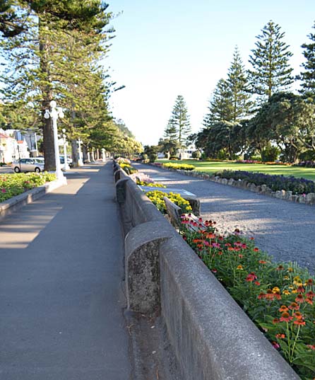
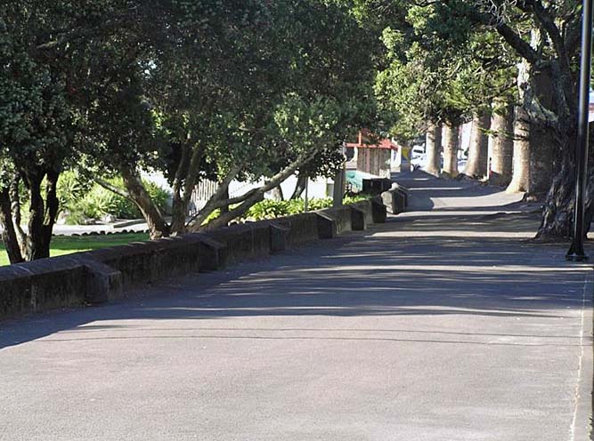
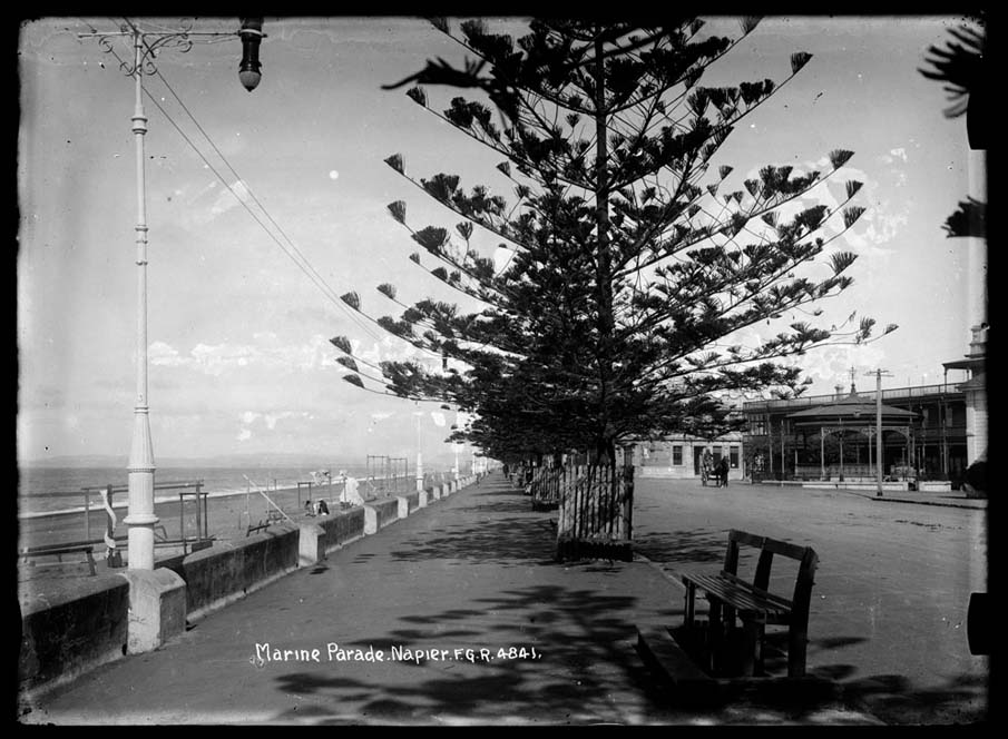
The impact of the sea wall was significant, both to people living in Napier in terms of protecting their property, but also for those wishing to promote the town as a tourist destination by allowing the formation of a beachfront esplanade. By the early twentieth century Napier was actively being advertised as resort town – sun, sea and an esplanade to make the most of both. Swan’s vision for Marine Parade saw the now iconic Norfolk pines trees planted parallel to the sea wall around 1891, footpaths built, and the provision for entertainment through installation of a band rotunda. In the early twentieth century, the area around the band rotunda, between Emerson and Byron Streets, played a central part of town life, being the scene of many notable civic events. All this was possible because of the protection provided by the Marine Parade sea wall. Where Mayor George Swan started the impetus of civic improvements in the town, one of his successors, John Vigor Brown (1854-1942) kept up momentum on Marine Parade, with bathing facilities, including the Swan Memorial Pool, developed during his initial time in office. The earthquake of 3 February 1931 wrought devastation throughout the Hawke’s Bay on a scale not witnessed before New Zealand, or, arguably, since. As with so much of Napier, the sea wall and surrounds were impacted, particularly the section to the north of Coote Road, which was destroyed by a large landslip from Bluff Hill. Given the prominence in the townscape there are many emblematic images in the days post-earthquake that show Marine Parade in a state of disrepair, the sea wall prominent amongst the devastation. The beachfront area proved vital in the days immediately post-quake as people set up camp on the beach, wary of seeking shelter in quake damaged dwellings. Furthermore, because the land uplifted by over six feet during the earthquake, the shore on the eastern side of the sea wall substantially increased leaving little functional need for the existing sea wall. While the civic beautification and tourism developments on Marine Parade in the late nineteenth and early twentieth centuries were figuratively and literally underpinned by the sea wall, this changed fundamentally after the 3 February 1931 earthquake. Mayor Brown, in his third and final stint in office (from 1927-33), guided the initial response to the quake, and established the structure that led the post-quake rebuilding of the town. The tragedy of the quake provided opportunity for renewing the town. In this milieu, Marine Parade was reformed and re-visioned to such a degree that the new civic space was much more than a mere reconstruction of what had been there before. The platform for developing this new beachside space was dumped rubble and debris from destroyed buildings in the town, and at this time small sections of the now redundant sea wall parapet were demolished to make way for new developments. The grand new Marine Parade included gardens, a sound shell, playgrounds and tennis courts on the new flat land created on top of the debris pile on the beachfront. Other sections of the above ground parts of the wall were incorporated into new developments, such as garden edging. However, most of the sea wall structure was buried by the new works. From the mid-1930s this part of Marine Parade also became an important commemorative space; the most substantial feature was the New Napier Arch, remembering the courage of Napier people during and after the earthquake. In post-quake Napier tourist promotions, Marine Parade was a dominant feature. While development slowed during the Second World War, other iconic additions were made to Marine Parade during 1950s, such as the Pania of the Reef statue, an outdoor skating rink, the Napier War Memorial and an aquarium. In the late 1960s Marine Land sea park was also opened on Marine Parade, becoming one of Napier’s major attractions. All these developments had an impact on the above ground parapet section of the sea wall. During infrastructure work in 2013 a 10 metre section of wall was removed and reinstated. This sparked local interest in the wall, to the extent that the Napier City Council installed a light well to allow the public to see the workmanship and extent of the sea wall below the ground.
Current Description Marine Parade Sea Wall (Former) was originally a dual-purpose structure, built both to protect Marine Parade and adjacent properties from tidal swells, and to retain the widening and improvement works of Marine Parade itself. The sea wall (parapet, main wall and foundations) was constructed using masonry, infill rubble, cement (cast slabs, plaster and mortar) and lime mortar. What remains of the visible parts of the sea wall is the parapet edge, sitting proud above ground level, approximately 660 metres long. The parapet is around 1 metre high at the southern end, but this varies along its length depending on adjacent development works that have raised ground level next to it. The rest of the sea wall still lies under the formation of the post-1931 development works. By 2018 subsurface remnants of the sea wall had been encountered as far south as 283 Marine Parade, and the potential for encountering the wall further south was noted. The extant sea wall parapet starts immediately after the northernmost column on the New Napier Arch. The other end of the sea wall looks like a simple curbed edge, the road surface having been raised over the years. This northern section ends 50 metres from the turn off to Napier Port road. The sea wall is studded with buttressing on its west side, added from 1889. The ones at the southern end have rounded tops, the northern end flat tops. Several small sections of the parapet have been removed over the years, to accommodate developments on Marine Parade. Archaeological reporting resulting from sewerage works in 2013 provided insight into the construction of the sea wall. The concrete parapet sits on top of dressed mortared stone walls (one town-side and one seaside) with the cavity between the walls filled with stone rubble and cement. This structure sits on a stone footing, which in turn sits on a 3 metre concrete foundation. The sea-side part of the wall is battered back towards the town-side (i.e. the outer wall has a backward slope), a common practice in stone wall construction that provides structural strength and deflects the force of waves. The extensive use of concrete in the Marine Parade Sea Wall, both as a mortar and in structural wall formation, was indicative of the burgeoning use of the material in a myriad of construction projects in New Zealand in the late nineteenth century. Comparative analysis Much of the extant marine protection works from the nineteenth century were built to protect coastal transport hubs in ports or coastal industry, or during land reclamation around harbours. There are examples of protection structures that were designed to protect settlements and associated infrastructure, many of them archaeological in nature. Major coastal towns did invest in creating and protecting promenades, like Napier, but many of these are later in construction or have been modified or replaced over the years. A comparable sea wall to the Marine Parade Sea Wall (Former) is the Rocks Road Sea Wall, in Nelson. It too was constructed in the late nineteenth century from concrete and stone and partly built using prison labour. The Rocks Road Sea Wall has been improved and modified over the years as well, although there are claims that most of the nineteenth century sea wall remains behind modern additions. Overall, there seems to be few sea protection walls or sea transport masonry structures of this vintage still in existence in New Zealand, but among them are a handful recognised on the New Zealand Heritage List/Rārangi Kōrero. These include the Otago Harbour Sea Walls (List No. 4726) and the Coronation Sea Wall at Devonport (List No. 4516). Both of these are in good condition relative to the Marine Parade Sea Wall (Former) and also retain their connection and proximity to the sea.
Public NZAA Number
V21/403
Completion Date
11th November 2019
Report Written By
Jackie Breen
Information Sources
Annabell, 2012
John Barry Annabell, ‘Planning Napier, 1850-1968,’
Daily Telegraph, 1981
Hawke’s Bay Before and After the Great Earthquake of 1931: An historical record (Napier: Daily Telegraph, 1981)
Report Written By
A fully referenced proposal summary report is available on request from the Central Region Office of the NZHPT.
Current Usages
Uses: Civic Facilities
Specific Usage: Wall/Fence
Former Usages
General Usage:: Civic Facilities
Specific Usage: Wall/Fence
General Usage:: Transport
Specific Usage: Sea-wall