

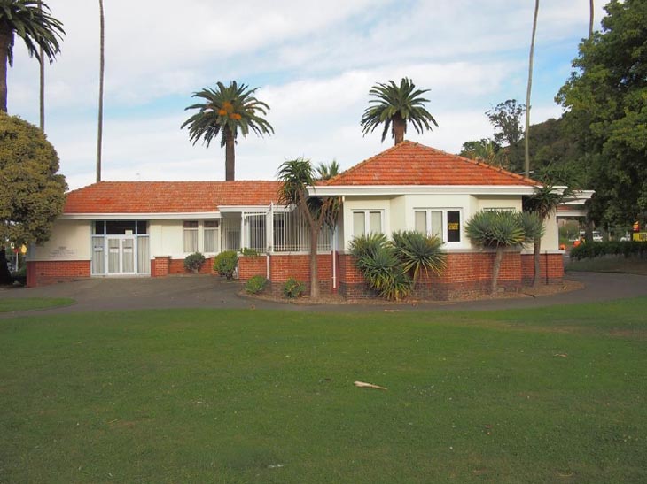
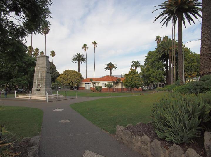
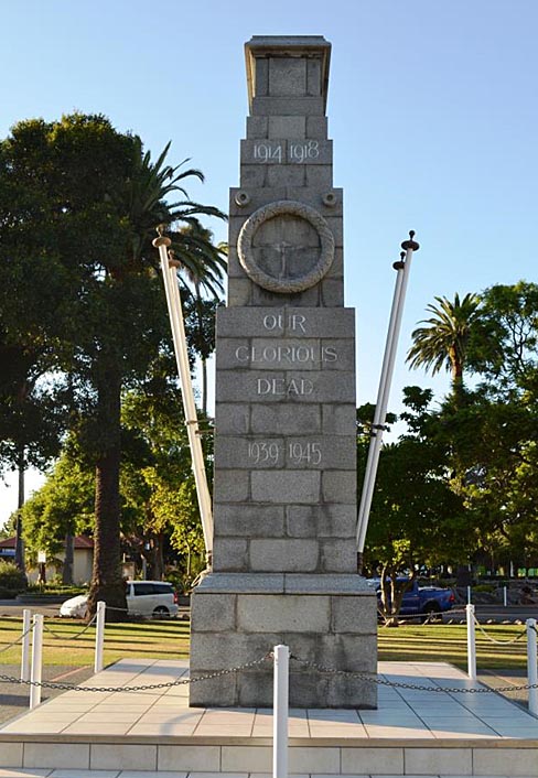
The Women’s Rest (Former), designed by notable New Zealand architect J. A. Louis Hay and opened in 1926, is an important part of Memorial Square in central Napier. It has special historical significance as a highly unusual utilitarian First World War memorial designed to benefit women, especially mothers with children, and its association as a ‘sibling’ memorial to the purely monumental Cenotaph demonstrates the complex post war debate about appropriate ways to honour the dead. It is a rare survivor of the devastating 1931 Hawke’s Bay earthquake. The Women’s Rest is also notable for its architectural and aesthetic values, and is a place with a strong community association and commemorative value. It is a key element within the twin squares of Memorial and Clive Square, which include other civic memorials. In 1924 the decision was made to build both a cenotaph and a ‘mother’s rest’ as First World War memorials at the northern end of Clive Square. The Cenotaph (List No. 1113) was completed first, in 1924. In 1925 Governor General Sir Charles Fergusson affixed a memorial plaque to the in progress ‘mother’s rest’ which stated that the building was a ‘Women’s Rest…erected by the people of Napier in commemoration of citizens of this town who fell in the Great War.’ The Rest contained rooms for the Royal New Zealand Plunket Society, a large rest room, kitchen and other facilities. It was officially opened on Anzac Day 1926, at which time northern Clive Square was renamed Memorial Square. The Rest is located in the western half of Memorial Square, amidst a network of curved footpaths. Its design was heavily influenced by the work of American architect Frank Lloyd Wright and the Prairie Style, and this influence is still readable in the building, despite changes since its original construction. Aspects of the Rest which reflect these stylistic influences include the building’s long low profile, cruciform internal layout, deep verandas (now enclosed), horizontal bands of windows, hipped Marseille tile roof with broad eaves and solid brick construction. Following the devastating 1931 Hawke’s Bay earthquake, temporary shops and offices were built around the Rest and short term repairs were made to the Rest itself, which had suffered extensive damage to some of its exterior walls. In 1934 the building was fully restored, retaining the original layout, roof and the base of the brick walls. Since then it has been used by many clubs and social welfare organisations, and as an event and civic space for community groups, as well as retaining its public toilets. Various alterations and additions were made over the years, including the closing in of verandah areas. In 1993 the Rest was substantially renovated by the Napier City Council to commemorate the centenary of women’s suffrage in New Zealand. Its name was changed to the ‘Memorial Square Community Rooms’ to acknowledge the broad use of the facilities by community organisations. In 2013, the Rest was closed to the public due to seismic concerns.
Location
List Entry Information
Overview
Detailed List Entry
Status
Listed
List Entry Status
Historic Place Category 1
Access
Private/No Public Access
List Number
1180
Date Entered
4th April 2020
Date of Effect
5th May 2020
City/District Council
Napier City
Region
Hawke's Bay Region
Extent of List Entry
Extent includes part of the land described as Lot 3 DP 22314 (RT HBW2/162; NZ Gazette 1992 p. 3134), Hawkes Bay Land District, and the building known as Women’s Rest (Former) thereon. The extent includes the concrete paths leading to and around the building. (Refer to map in Appendix 1 of the List entry report for further information).
Legal description
Lot 3 DP 22314 (RT HBW2/162; NZ Gazette 1992 p. 3134), Hawkes Bay Land District
Cultural Significance
Social Significance or Value The Women’s Rest (Former) was created to provide a safe and welcoming public space for women at a time when the domestic sphere was still considered most appropriate for them. The toilets provided an essential facility for women while they were in the city no matter their background, occupation or marital status. The Plunket rooms drew both women and children into the building for health and education purposes. More broadly, the Rest provided a space for women to meet, gather, make connections, have shared experiences, learn and develop. Over time the Rest became accessible to both women and men and the organisations using parts of the Rest changed, but the core social function remained. Many Napier and wider Hawke’s Bay residents will have shared common experiences in the Rest until its closure in 2013. The Napier City Council faced opposition in 2017 when it proposed a new building next to the Square in which the Rest sits, potentially requiring the destruction of the Rest. Currently, having been closed for approximately six years, the Rest is currently unable to perform its social function. However, its wide use historically by various clubs and organisations has ensured strong connections across generations.
Historic Significance
Historical Significance or Value The Women’s Rest (Former) has special historical significance due to its direct connection with four significant aspects of New Zealand history: the provision of facilities that accepted and enabled women’s presence within the public realm, the health of mothers and babies as promoted and shaped by the Royal New Zealand Plunket Society, the memorialising of New Zealand’s involvement in the First World War and the devastating 1931 Hawke’s Bay earthquake. It is highly unusual and significant in that it was built as a war memorial following the First World War, when ‘useful’ memorials were not generally considered appropriate and its situation next to a cenotaph illustrates a compromise between the ‘useful’ and ‘traditional’ war memorial philosophies. It has further significance as a war memorial dedicated to use by women and children. The Rest is one of the few buildings in central Napier to survive the 1931 earthquake and played a key role in the re establishment of shopping and office facilities immediately following the earthquake. Its appearance following its 1934 restoration reflects changes in design and construction. It also has post earthquake significance in its use by a wider variety of social and community organisations, reflecting changes in society over subsequent years to the point that it is no longer a designated women’s space but a community space.
Physical Significance
Aesthetic Significance or Value The Women’s Rest (Former) has aesthetic significance and appeal within the context of Memorial Square, a green space in central Napier with established trees (including palm trees), shrubs and well-maintained lawn areas and paths. Photographs of the Rest within Memorial Square have been used to promote Napier in publications such as the Thirty Thousand Club’s Sunny Napier in the 1950s. The proportions of the brick base, the painted exterior and the terracotta-coloured Marseille tile roof are pleasing to the eye, while the two types of brick used at the base of the building add a further detail of colour and texture. The domestic proportions of the Rest within the setting of the park combine to imbue the structure with a sense of the very thing the building was designed to provide: rest. The 1969 all-brick rear addition to the building includes a decorative vertically stepped brick wall which echoes the angles and materials of the building while injecting a more modern element. Architectural Significance or Value The Women’s Rest (Former) has architectural significance as a reflection of the Prairie Style of architecture which was favoured by its architect J.A. Louis Hay, who was influenced by the work of Frank Lloyd Wright. The Prairie style was not widely adopted outside the United States, and is particularly characteristic of the Hawke’s Bay region due to Hay’s designs for domestic and civic buildings. Whilst the Rest has undergone some change since its original construction, it has remained true to the original design, as exemplified by features such as the building’s long low profile, deep verandas (now enclosed), horizontal bands of windows, hipped roof with broad eaves and choice of brick as the primary construction material. The Rest has additional architectural significance as a pre 1931 earthquake example of the Prairie Style, which became more prevalent post earthquake, with Hay designing a number of buildings in this style.
Detail Of Assessed Criteria
It is considered that this place qualifies as a Category 1 historic place. It was assessed against all criteria, and found to qualify under the following: a, b, e, g, h, k. (a) The extent to which the place reflects important or representative aspects of New Zealand history The Women's Rest (Former) is a purpose built combined women’s restroom and Plunket rooms built in the decade when the idea of such facilities was becoming widely accepted by local authorities. As such, it reflects important developments in the provision of public facilities for New Zealand women and children. Along with its Hastings equivalent and others such as Manaia, Te Aroha and Marton, the Rest can be seen as an exemplar of a pattern repeated throughout the country, where women's rest rooms were established, and by extension women's access to and visible place in the community. The building also represents the importance of the Plunket Society in the history of health services in New Zealand, particularly as it was placed in prominent location designed to enable convenient access for mothers in close proximity to shops, services and the green spaces of Clive and Memorial Squares. The Rest also reflects the period of memorial building following the First World War and the public debate over the form that memorials should take. It is a highly unusual example of a ‘useful’ memorial built after the First World War for the specific benefit of women and children, at a time when such memorials were not considered the best way of mourning New Zealand’s service personnel. (b) The association of the place with events, persons, or ideas of importance in New Zealand history The Women’s Rest (Former) is associated with the devastating 1931 Hawke’s Bay earthquake. It survived the earthquake and played an important role in the recovery of the city housing ‘beneficent public services’ and being wrapped in the so called ‘Tin Town’ to provide continued amenities to the damaged town and community during rebuilding. This type of provision is recognised as an aspect of cultural resilience. The Rest’s appearance is a direct result of changes made to design and building methods following the earthquake. The Rest is also associated with prominent New Zealand architect J.A. Louis Hay and reflects his signature Prairie Style of architecture, which was influenced by the work of American architect Frank Lloyd Wright. Hay was important to the architectural style of Napier both before and after the earthquake. He completed extensive work towards the reconstruction of Napier in the 1930s as a member of Associated Architects, the co-operative design organisation who led the post earthquake reconstruction of Napier. (e) The community association with, or public esteem for the place The Women's Rest (Former) is held in considerably high regard by the Napier community. The construction of the building was funded partly by private donations and alterations in 1993 were made under the auspices of the women’s suffrage centenary in New Zealand. Until 2013 the building was a widely used community facility containing public toilets, office space for community focused organisations and a venue for meetings, events and classes. When the building’s demolition was mooted in 2017 members of the public objected to the proposal. (g) The technical accomplishment, value, or design of the place The Women’s Rest (Former) has technical value through its post earthquake restoration which provides evidence of changes in building materials and construction methods in response to the earthquake. The restoration involved creating temporary supports for the roof while internal and exterior walls were rebuilt and brick from the original exterior walls was reused where possible; these are early examples of post earthquake restoration technical accomplishment and sustainable building practices. The Rest has further significance as an early, pre earthquake example of the Prairie Style of architecture which was to become a signature of architect J.A. Louis Hay. The Prairie Style adds to the richness and significance of Napier’s architectural heritage, which is primarily known for the Art Deco style. (h) The symbolic or commemorative value of the place The Rest was originally constructed as a First World War Memorial and sits within Memorial Square, next to the Cenotaph. A commemorative plaque in a prominent location on the exterior of the building explicitly states both the original function of the building as a women’s rest and its commemorative function. The relationship between the Women’s Rest and the Cenotaph, within the renamed Memorial Square, is of special commemorative value as these two memorials offer complementary but intertwined perspectives of the debate about what New Zealanders’ considered were appropriate ways to honour those who were lost in World War One. As a women’s rest room, Plunket Rooms and the site of the Young Women’s Christian Association during the Second World War, the Women’s Rest (Former) has a long connection to the history of women in Napier and the surrounding countryside. This was further cemented in 1993 when it was renovated as part of Napier’s commemoration of 100 years of women’s suffrage in New Zealand. (k) The extent to which the place forms part of a wider historical and cultural area The Napier Women's Rest (Former) is located in the central business district of Napier, within the neighbouring squares, Memorial Square and Clive Square. Archaeological work in 2019 found evidence of pre European Māori occupation of Clive Square. Following European settlement the squares have been the site of a number of important events in Napier’s history. They were the gathering place for Napier’s first Anzac commemoration in 1916 and played a crucial role in the city’s recovery after the 1931 earthquake. The Squares also contain lawn, established trees and planting, and other civic memorials including the Cenotaph (List No. 1113), and the Blythe Memorial Fountain (List No. 1110) which contribute to the squares’ commemorative focus. The Rest sits within the extent of the Napier City Centre Historic Area (List No. 7022). Although the Rest is architecturally distinctive from the city’s Art Deco buildings, it sits comfortably within the Historic Area and is a rare and important example of a Napier public building that survived the 1931 earthquake. The Rest’s role as a home for public services and a structural support for temporary shops and offices immediately following the earthquake, as well as its subsequent rebuilding, adds to the understanding of pre and post earthquake Napier and expands the historical narrative that can be told through the structures contained within the Historic Area. Summary of Significance or Values Napier’s Women’s Rest (Former) has special significance as a highly unusual utilitarian First World War memorial that provided specifically for the needs of women and children, and as a symbol of cultural resilience for its role in the recovery of the city after the 1931 Hawke’s Bay earthquake. The building epitomises a number of significant aspects of New Zealand’s history, including important developments in the provision of public facilities for New Zealand women and children, and the post First World War debate about how best to memorialise the war and those who lost their lives. The Rest is architecturally significant as a pre 1931 earthquake example of the Prairie Style of architecture favoured by architect J.A. Louis Hay and its design marks it out as a distinctive amongst the prevalence of Napier’s post earthquake Art Deco buildings in the central city around it. The Rest also has special commemorative value, commemorating both the First World War and women, as reflected by its 1993 renovation to commemorate the centenary of women’s suffrage in New Zealand, and for the special light its relationship with the ornamental Cenotaph can shed on the complex aftermath of World War One and New Zealanders’ reactions to the powerful social need to honour the dead. It is also socially significant as a focal point for the community for over 85 years, during which time its facilities were used for social services, community groups, classes and public toilet facilities. The community association for the Women’s Rest was demonstrated by their opposition to the 2017 proposal to demolish the Rest. Whilst currently closed to the public, the Women’s Rest remains a key contributing element within the twin squares of Memorial and Clive Square, which include other civic memorials.
Construction Professional
Biography
No biography is currently available for this construction professional
Name
Smith, Frank
Type
Builder
Biography
J A Louis Hay (1881-1948) was born at Akaroa, Banks Peninsula. He attended Napier Boys' High School and worked for both D T Natusch and Walter P Finch. Hay developed a strong interest in the work of William Morris (1834-1869), Louis Sullivan (1856-1924) and Frank Lloyd Wright (1869-1959). On completion of his training Hay worked both in Dunedin and Australia before returning to Napier to commence practice on his own account. Hay was chairman of the Hawkes Bay branch of the New Zealand Institute of Architects and was the Institute representative on the Napier Reconstruction Committee after the 1931 earthquake. He also did extensive work toward the reconstruction of Napier in the 1930s as a member of Associated Architects, a co-operative design organisation whose members included the principals of the three other major architectural practices in Napier at that time - C T Natusch and Sons, Finch and Westerholm and E A Williams. In collaboration with these architects Hay contributed to the Marine Parade Development plan, and the reconstruction of Napier Public Hospital. In his own practice Hay was responsible for the designs of the National Tobacco Company Building (now Rothman's), Ahuriri (1933), the Hawkes Bay Art Gallery and Museum (1935), and the Hildebrandt Building, Tennyson Street (1932). His domestic work includes 'Waiohika', Greys Bush, Gisborne (1920).
Name
Hay, James Augustus Louis
Type
Architect
Construction Details
Finish Year
1925
Start Year
1924
Type
Original Construction
Description
‘Sunporch’ enclosed
Finish Year
1942
Type
Addition
Description
Substantial alterations and additions made including the closing in of part of the verandah and a rear extension
Finish Year
1958
Type
Modification
Description
Extension to toilets to create separate male and female toilet blocks
Finish Year
1969
Type
Modification
Description
Further extensions and alterations to north east corner to create office spaces and a reception
Finish Year
1981
Type
Modification
Description
Hawke's Bay earthquake. Earthquake damage, followed by temporary repairs
Start Year
1931
Type
Damaged
Description
Hawke’s Bay earthquake damage repaired
Finish Year
1934
Start Year
1931
Type
Maintenance/repairs
Start Year
1993
Type
Refurbishment/renovation
Construction Materials
Concrete, brick, timber, plaster, Marseille tiles, glass.
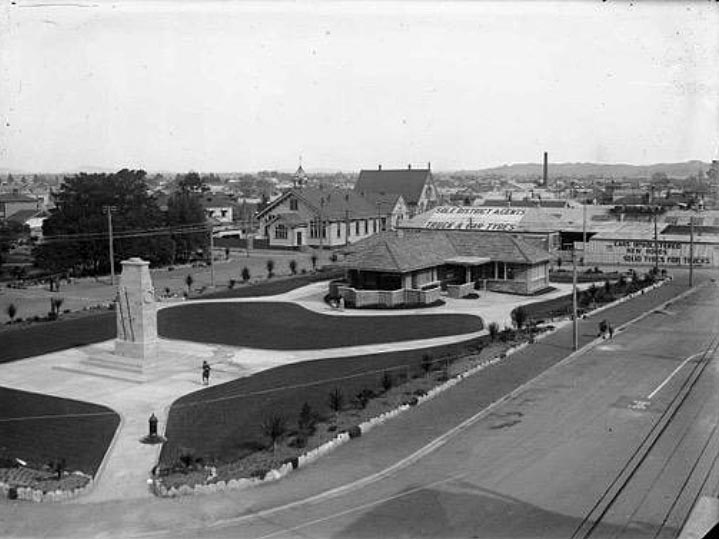
Early Napier The Ahuriri area’s rivers, wetlands, lagoons and fertile land produced important resources, making it an attractive place to live. Settlement is thought to have begun in the twelfth or thirteenth century and Ngāti Kahungunu became the dominant iwi from the sixteenth century. There were several pā at what became Port Ahuriri and Napier. As a result of inter tribal warfare, around the 1830s many local Ngāti Kahungunu sought refuge in Māhia. When missionaries and other Europeans began arriving in earnest after the signing of the Treaty of Waitangi, the exiles had returned and Te Koau, near Te Pakake, became the principal local pā. With the Ahuriri Purchase of 1851, the Crown acquired the lands between the Tutaekuri River and north to the Mōhaka area, inclusive of Mataruahou (Napier Hill) and most of its surrounds. A few years later, in 1855, Napier was established by the government, with the town primarily located on the hill and around its base, as well as the narrow spits extending south and west. The site was not promising because road access was difficult and future expansion would be challenging. However, Napier had a port, which was an important factor in Napier becoming Hawke’s Bay’s early administrative, commercial, and social centre. The 1885 town plan for Napier was produced by Alfred Domett (1811 1887), Commissioner of Crown Lands in Hawke’s Bay, and included an area of land named Clive Square, envisaged as a recreation space or ‘village green’. Archaeological work has found evidence of pre-European Māori occupation of Clive Square. From early on in Napier’s colonial history, Clive Square was used for sporting and cultural activities and entertainment. In 1884, private funders supported the Napier Borough Council to undertake ‘beautification’ of the southern end of the Square, including gardens and a band rotunda. The northern end was left undeveloped to serve as the playground for Napier Main School located across the road. Despite being used for many years as a road, it wasn’t until 1962 that a strip of land dividing Clive Square gained the status of a legal road (Emerson Street). Memorialising the First World War Troops had assembled at Clive Square before departing for the First World War, and on 25 April 1916 a large crowd gathered there for the procession that marked Napier’s first Anzac Day commemorations. As such, it was fitting that after the war Clive Square became a centre for Napier’s remembrance of its fallen soldiers. Following the end of the First World War there was widespread debate about what form war memorials should take. Initially, many communities showed enthusiasm for ‘useful’ memorials such as halls, hospitals and bridges. However, advocates of more traditional European style monuments argued that utilitarian memorials obscured the heroic deeds they were meant to remember, and their memorial purpose would soon be forgotten. Instead they favoured traditional monuments as artistic expressions of the principles service personnel had fought for, and would serve as a ‘surrogate tomb’ for families whose sons lay buried overseas. Ultimately the anti utilitarian argument triumphed and as a result only a limited number of ‘useful’ First World War memorials were constructed. The decision to erect both a women’s rest and a cenotaph as a war memorial in Clive Square was perhaps a compromise between these two schools of thought. The limited number of ‘useful memorials’ built after the war makes the Napier Women’s Rest highly unusual, and it is made even more unusual because it is a war memorial specifically providing for the needs of women. There was much discussion about the form war memorials should take throughout the Hawke’s Bay. A province wide Hawke’s Bay Memorial Fund eventually funded the Hastings Cenotaph (1923, List No. 1083), and the Hawke’s Bay Fallen Soldiers Memorial Hospital (1927) in Hastings. In Napier, the Plunket Society made an early suggestion of a ‘baby hospital’ as a memorial, and a large public appeal was made in 1919 to raise money towards a new boys’ war memorial college, but this idea appears to have been dropped the following year. By late 1921 the Napier War Memorial Committee had received ‘no less than 20 suggestions…as to what design the Napier memorial should be.’ In February 1924, more than five years after the end of the war, the Poverty Bay Herald noted that ‘considerable controversy has taken place at Napier, extending over a lengthy period, respecting the erection of a suitable war memorial. It has now been decided that the memorial should take the form of a mothers’ rest and cenotaph in the northern portion of Clive Square.’ The Cenotaph was finally unveiled on 9 November 1924, and another war memorial, a large stone cross, was unveiled a few months earlier in 1924 in front of Napier Cathedral. Women’s Rests The popularity of the Hastings Municipal Women’s Rest, which had opened three years prior to the decision to erect a mothers’ rest in Napier, may have influenced Napier’s choice of war memorial. The Hastings Rest is likely to be the first example of a women's rest built exclusively and separately for this purpose in New Zealand, and almost 10,000 visitors made use of that facility in its first year. Access to public toilets was a very practical element of the broader fight for women’s rights in New Zealand. New Zealand’s major urban centres have long had more female than male inhabitants, yet it took decades for the provision of public toilets for women to catch up with those for men. By the 1920s, women’s organisations were actively campaigning for ‘rest rooms’ for women. As Caroline Daley has noted, ‘public conveniences were necessary for women to be more active participants in the life of their city’ but local government resisted the idea, arguing that women would not want to be seen entering a public space so obviously linked to basic bodily functions. This sense of propriety is why women’s ‘rest rooms’ were initially more than just the basic toilet and wash basin facilities afforded to men, but comfortably appointed spaces where women could ‘refresh’, wait, get changed after work and attend to the needs of young children as well as relieve themselves. They became highly valued not only by urban residents but also by country women visiting town. In the case of both Hastings and Napier, these buildings were made to look as comfortable and homelike as possible. Napier Women’s Rest The plans for the ‘mothers’ rest’ were completed by James Augustus Louis Hay in May 1925. Hay was one of Hawke’s Bay’s most prominent early twentieth century architects and his early work was mainly domestic for wealthy private clients; the Women’s Rest, along with the Napier Soldiers’ Club (1916) and Napier Central Fire Station (1921) were the only public commissions in his pre earthquake portfolio. After the 1931 earthquake, Hay was a significant contributor to the rebuilding of Napier, designing prominent civic and commercial buildings such as the National Tobacco Company, AMP, Bowman and Hildebrandts buildings, Parkers Chambers, and the Hawke’s Bay Art Gallery and Museum, among others. He was also a member of the Napier Reconstruction Committee, ‘which meant that he was vitally involved in the decisions regarding the rebuilding of the destroyed town.’ Hay was heavily influenced by American architect Frank Lloyd Wright and the Prairie Style of the American Midwest, which was defined by an ‘emphasis on the horizontal rather than the vertical’. Buildings often include flat or shallow hipped roof lines, brick or stucco exteriors, connected indoor and outdoor spaces and restrained use of ornamentation. These features are all evident in the original design of the Napier Women’s Rest, constructed in brick with a low hipped roof and deep eaves which enhance the building’s horizontal emphasis. An important part of the original function of the building was that it was to serve as a Plunket Rooms. The Royal New Zealand Plunket Society was by this time a national health institution. Plunket Rooms were built in each town, funded by a local committee of women, where mothers could bring their babies to be checked by Plunket nurses. Often the functions of women’s rest rooms and Plunket rooms were combined in one building. The finance raised for the building of Napier’s Women’s Rest came partly from donations, so it is likely that some of these donations came from Plunket Society fundraising. The original plans for the Women’s Rest show a deep verandah wrapping around the front three sides, including a ‘piazza’ space at the front of the building, with the low wall forming a v shape (similar to features in some of Frank Lloyd Wright’s house plans), and built in seats and flower boxes. The walls were constructed from double brick, lined with plaster. Internally there was a large central ‘rest room’, which featured a large curved brick fireplace, akin to fireplaces in houses designed by Lloyd Wright. Along the front of this space were large sliding wooden double doors opening into the piazza space. To the left of the rest room was a kitchen and an ‘elderly women’s room’. A hall and Plunket waiting rooms were to the right. The Plunket nurse’s office (accessed by a ramp), six toilets and a boiler room ran along the back of the building. A set of lockers were in the passageway. During an official visit to Napier, the Governor General, Sir Charles Fergusson, affixed a memorial plaque to the in progress Women’s Rest on 24 October 1925, on an exterior wall beside the main door. After the ceremony the Governor General met Hay and ‘complimented him upon the fine building’ and the Napier Girl Guides paraded on the grounds. The marble plaque clearly denoted the building as a women’s rest, but also as a war memorial. The completed building was opened by Mayor J. B. Andrew as part of Napier’s 1926 Anzac Day commemorations. A photograph of the opening ceremony shows a huge crowd gathered in the Square and on the building’s verandah. During his speech, the Mayor announced that the northern end of Clive Square on which the Women’s Rest and Cenotaph stood would be renamed Memorial Square. He stressed ‘the benefit that would accrue by embracing the Plunket rooms within the building’. He also thanked the Mayor and citizens of Hastings, who had given advice based on their experience of their own Women’s Rest. Images of Memorial Square at this time show new concrete paths wrapping around the Rest and the Cenotaph, closely clipped lawns and newly planted palm trees; a more formal space than the Clive Square gardens to the south. Just after the opening, a newspaper reported ‘Napier has every reason to feel proud of its memorial to its glorious dead…With its Cenotaph, Mother’s Rest and beautifully laid out grounds…the square is now one that the residents can take pride in.’ Indeed, entries in the 1926 1946 Visitors’ Book include comments that it was ‘Very comfortable & convenient’, ‘A great asset to the town’ and ‘Splendid in every appointment’ and one visitor from England commented it was ‘The nicest war memorial I have seen’. The building would not simply have been used by women accessing the toilets, but as a place for women working in offices to spend their lunch hour and for rural women visiting the city for the day to rest and obtain light refreshments, warm their babies' bottles, leave their parcels and write letters. The Council appointed a ‘matron’, who cared for the building and its visitors. In June 1929 it was reported that 1,400 visitors had patronised the Rest in just one month. During the 1920s and 1930s residents of other small towns expressed a wish to copy the example of the women’s rests in Napier and Hastings. Earthquake and Recovery On 3 February 1931 a magnitude 7.8 earthquake killed at least 256 and injured thousands more in Hawke’s Bay. Buildings in Napier and Hastings crumbled and fire quickly tore through Napier’s central business district. The damage was catastrophic. A small plaque affixed to the Rest above the original plaque now states it was ‘Destroyed by earthquake 1931 / Rebuilt 1934.’ While the word ‘destroyed’ implies the building was irreparably damaged, this seems to be an exaggeration. A photograph of the Rest following the earthquake shows a corner of the exterior wall reduced to a pile of bricks, and other photographs show the chimneys no longer in place but the roof still intact. Indeed, the entire roofline of the Rest is visible in photographs taken soon after showing what became known as ‘Tin Town’. The Rest has a strong connection to post earthquake life from 1931 until 1933. In the weeks following the earthquake, the rebuilding of central city business premises was forbidden, to allow thoughtful planning of the town centre’s reconstruction. Instead, government funding was provided for the construction of temporary shops and offices in Clive and Memorial Squares. In Memorial Square, the roofs of the corrugated iron structures (hence ‘Tin Town’) were directly connected to the roof of the Rest, effectively ‘wrapping’ the Rest building, except for its front and rear façades. It was then used as base for post earthquake recovery: a newspaper report from November 1931 mentions the ‘Women’s Rest has been partially restored and made habitable, and is housing three of the beneficent public services that are operating for the benefit of citizens.’ By May 1933, ‘Tin Town’ had been completely dismantled. Four schemes were considered for the restoration of the Rest. Hay (the original architect) was consulted during this process. Three of the schemes involved retaining only the back wall of the building and demolishing the remainder for complete reconstruction with timber framed walls and a plaster finish. Hay himself noted that this way the Council ‘may feel sure that the building will not only be safe, but will help those using it to forget the earthquake. With bright tinted walls and suitable relief it should become a distinct acquisition to this part of the town’. It appears the Council proposed making the Rest into a ‘general utility place’, but the Napier Returned and Services Association (RSA) vigorously protested any change of use. The Association opposed the building being ‘turned into a women’s club’ and recalled ‘we had trouble some years ago when some people started playing bridge there, but we soon squashed that’. They also noted that the terms of the loan raised to build the Rest specified it was to be both ‘a Women’s Rest and a soldiers’ memorial’. In August 1934 the Borough Engineer examined the building and found the walls ‘pretty extensively damaged,’ but the lower portions of the brickwork reasonably sound. Unlike previous schemes, the engineer’s new scheme for repairs aimed to ‘make the building light and flexible while not losing the general original form’. It retained the existing exterior brickwork up the height of the lower windowsills, then constructed the remainder of the exterior walls with timber framing and plaster, and the internal walls with either hollow reinforced concrete block or timber framing. The engineer also specified products meant to be safer in earthquakes in the future. The heating was electric but the chimney in the main room was rebuilt with a fireplace on a smaller scale. The roof was supported by false work while the walls were pulled down and rebuilt. The Department of Labour provided a subsidy to employ registered unemployed men to complete the work; it must have progressed quickly because just before the end of 1934 the Rest was reopened. Second World War and After At the beginning of the Second World War the Rest was leased to the St John’s Ambulance Association, on the condition that it provide an attendant to maintain the Women’s Rest Room, as well as the Hawke’s Bay Merchant Navy Club and the Young Women’s Christian Association (YWCA). In 1942, soldiers were using the Rest for recreation on weekends and a sunporch was enclosed to create another room. In 1947, the Plunket Society was given a large donation by the United Friendly Societies to build a crèche within the building, although it is not clear whether this eventuated. In the 1950s a booklet created to attract visitors to Napier called Sunny Napier contained photographs of the Rest as a feature of the town. St John’s and the Merchant Navy Club remained in the building after the war and during the 1950s some alterations were made to the building. Parts of the veranda were enclosed and an extension was added to the back. By 1958 the Merchant Navy Club had sole lease of the Rest; as part of the lease, the club were required to ‘keep the public conveniences open and a responsible person in attendance’ during weekdays, to ‘provide teas for women and girls at reasonable charges and the heating of babies bottles’ and to clean and maintain the building. In 1969 further additions were made to the south west corner of the Rest to create separate men’s and women’s public toilet facilities, with external doors to enable access without entering the main building. By the 1970s parts of the Rest were being used by a variety of social services including the Presbyterian Social Service Association, which operated a ‘Day Centre for elderly and disabled people.’ By 1981 the Rest included a Citizens Advice Bureau, which undertook its own extensions and alterations, including the removal of built in brick planter boxes to enable an extension to the north east corner. In 1993 the toilets located in the south west corner of the building were again renovated. At this time a 20 cent charge for use of the toilets was instituted to recognise the serviced nature of the toilets. The ‘Women’s Rest Area’ became a Community Rest Room, available for ‘general use under supervision to take into account male caregivers’, and the Rest’s name was changed to the ‘Memorial Square Community Rooms’, removing the named connection between women and the building. Its reopening in 1993 was used as Napier’s official celebration of the centenary of women’s suffrage in New Zealand. The different spaces within the Rest could be hired by community groups, and for functions. In April 2013 a seismic report recommended the building be vacated until strengthening was carried out. The Citizen’s Advice Bureau vacated the building and it was closed to the public. Temporary metal gates were erected in 2016 as a security measure. In 2017 the Napier City Council considered options for building a new public library in the city, including possibly incorporating the Rest into the new structure or demolishing the Rest completely a fate which the Art Deco Trust had considered there was little likelihood of in 2013 because of it being a building of such special interest. The Council faced community opposition to the idea of demolishing the Rest, which currently remains closed to the public.
Current Description Setting The Women’s Rest (Former) occupies the western half of Memorial Square in central Napier. Seven entrance points connect the Square to the footpath, providing access from Clive Square East, Clive Square West, Tennyson and Emerson Streets. Established trees and shrubs around the perimeter of the Square and car parking spaces that border the Square on all but the Tennyson Street side help to shield the Square from the noise and activity of central city traffic. The Cenotaph is also situated in the Square, but an expanse of lawn lies between the Cenotaph and the Rest, creating distinct spaces within the Square for each. These distinct spaces are enhanced by the pattern of the concrete paths surrounding and connecting the Cenotaph and the Rest: the paths leading directly to the Cenotaph from the footpath are straight edged with lighter coloured decorative diamonds and stars set into the concrete, while those leading to and around the Rest are gently curved and do not contain decorative elements. The Rest Exterior Since it was constructed in 1925 6, the Rest has been incrementally modified but continues to give the impression of a cohesive design, particularly when viewed from the east. A number of the distinctive Prairie Style architectural features have been lost, although the basic form of the single storey building remains the same, and the design influence is still readable. The verandahs that originally wrapped around the building’s long central room have been closed in at the front and on the northern end, and additions have been made to the north and rear of the building. Approximately seven rows of the original red rusticated brick form the base of the building all the way around, except in the south west corner where additions and alterations were made in 1969 and 1993. Above this, on the eastern, northern and southern sides of the building, lighter coloured smooth brick continues up to a protruding concrete band (painted light grey) below window sill height, followed by smooth plaster (painted cream) to the roofline. Some of this brickwork is visible on the interior, although painted. The western exterior wall, as well as short expanses of the north west and south west walls, is brick to the roofline as the result of an entirely brick addition made to the back of the building around 1958. The south west portion of the addition includes a decorative vertically stepped brick wall created as part of the 1969 alterations and preserved during the 1993 alterations. To the east of this decorative brick wall, next to double aluminium and glass doors reached either by a ramp or steps, is a commemorative plaque affixed in 1993 which reads: ‘Memorial Square Community Rooms / In Commemoration Of The Celebration of / 100 Years Women’s Suffrage / These Community Facilities Including The Former / Women’s Restrooms Were Extensively Renovated / Officially Opened By The Deputy Mayor Of Napier City / CR Anne Tolley J.P. / 31 July 1993’. The original cruciform core of the building is covered in a hipped roof with Marseille tiles, and there are a number of flat roofed additions. The south east porch retains brick planter boxes (the same height as the exterior wall brick) connected to the building. These planter boxes can be seen on the original plans for the Rest as well as the plans for the post-earthquake reconstruction and offer the best sense of what the deep verandahs would have been like prior to their enclosure. Both the south east porch and a smaller northern porch are currently enclosed by white metal security gates/grilles. A chimney for the original main ‘rest room’ space remains and the other chimney, at the rear of the building, seems to be contemporary with the 1969 additions. Some external door and window joinery is timber and likely to be original to the post 1931 earthquake reconstruction of the building. A number of the timber framed windows feature an upper leadlight section of mostly uncoloured glass, however, some of the leadlight sections in the south east porch area and the northern most part of the original cruciform floorplan feature tiny coloured sections. The remainder of the external window and door joinery is aluminium. The colour scheme of the door and window frames varies from light blue to white or cream. Two commemorative plaques are affixed to the south east exterior wall directly above the protruding concrete band (moved from their original location). The lower, larger marble plaque laid by the Governor General in 1925 reads: ‘Women’s Rest / “Repose Is The Cradle Of Power” / Erected By The People Of Napier In Commemoration Of / Citizens Of This Town Who Fell In The Great War / 1914 1918 / This Stone Was Laid On 24th October 1925 By / His Excellency General Sir Charles Fergusson, Baronet; L.L.D., G.C.M.G; K.C.B., D.S.O., M.V.O. / Governor General Of New Zealand’. The smaller, upper marble plaque marking the restoration of the building following the 1931 earthquake reads: ‘Destroyed By Earthquake / 1931 / Rebuilt 1934’. The Rest Interior Internally, the original central ‘rest room’ still occupies the greatest footprint. Smaller rooms used as offices and a reception area border this central room to the east and north, where the verandah was enclosed. Three other large rooms run out to the north, west and south points of the building with double doors opening onto Memorial Square from the southern room. Toilets and other facilities, such as a shower room, occupy the south west portion of the building and the building is equipped with two kitchens and various smaller storage rooms/offices.72 The building has been adapted for various uses overtime and this is reflected in a range of fixtures and fittings, as well as partition walls and ceiling treatments. Comparative Analysis Women’s Rest Rooms The Napier Women’s Rest (Former) is an example of a purpose built women’s rest built in the decade (1920s) when the idea of such dedicated facilities gained traction in New Zealand. Initially having to use private or business premises, limited public lavatories for women began appearing in the early twentieth century. However, in the absence of dedicated civic provision, women’s organisations such as the Women’s Christian Temperance Union had proactively adapted existing sites since at least 1898, when the local New Plymouth branch secured use of one room of the Borough Council Chambers and transformed it into a ladies’ sitting room with lavatory. Other branches followed suit, furnishing similar conveniences sometimes with the assistance of borough councils and by the end of the First World War it can be assumed many towns in New Zealand had some sort of public toilet and rest facilities available for women. The Hastings Municipal Women’s Rest (List No.1105, Category 1), built in 1921, is believed to be the first building in New Zealand that was specifically designed, constructed and dedicated exclusively as a combined women’s toilets and Plunket rooms. Other purpose-built examples from the 1920s include the Manaia Women’s Rest (1922, extant), the Lower Hutt Plunket rooms, dental clinic and women’s rest (1924, appears to have been demolished) and the Te Aroha Ladies’ Rest Rooms (1925, current situation unknown), among others. It was common for these facilities to include rooms for the use of the Royal New Zealand Plunket Society, who often assisted with fundraising towards the building. The construction of the Napier Women’s Rest sits in the middle of this decade, as it was delayed for a number of years while the form of Napier’s war memorial was debated. There is another World War One Memorial Rest Room in Whakatāne, which opened in 1934 to commemorate members of Ngāti Awa who had served. However, that rest room is an open sided general shelter and does not appear to contain toilet facilities. Along with the Hastings Women’s Rest, three other women’s rests are currently entered on the New Zealand Heritage List/Rārangi Kōrero: the Marton Rest Room (1927, List No. 2840), the Nelson Plunket and Rest Rooms (1936, List No. 5169) and the Ōamaru Centennial Memorial Rest Rooms (1941, List No. 2284). The Marton Rest Rooms also contain a Plunket rooms and are from the same construction period as the Napier Women’s Rest, however do not share the memorial function. The Oāmaru Centennial Memorial Rest Rooms were part of a swathe of rest rooms and Plunket rooms built to commemorate the 1940 New Zealand centennial; that time utilitarian memorials were encouraged by the Government. Other examples include the Greytown Centennial Memorial Rest Room (demolished in 2013), the Greymouth Women’s Centre (extant) and the Papakura Centennial Rest Room (extant). A common feature of early purpose built women’s rest rooms was their single level domestic appearance. The Hastings Women’s Rest was built in the Californian Bungalow style and the Marton Rest Room in the Arts and Crafts style, while the Manaia Women’s Rest is very simple with a gabled roof and roughcast exterior. Among early women’s rests, the original design of the Napier Women’s Rest is distinctive in its Prairie style with deep verandas, long low profile, cruciform internal layout and use of brick as the primary building material. While the exteriors of the women’s rests in Hastings and Marton have undergone little alteration since their construction and continue to provide facilities specific to women and/or children, the changes to the Napier Women’s Rest tell a unique story of earthquake survival, post-earthquake adaptation and evolved community use. The Prairie style of the Napier Women’s Rest also sets it apart from a number of later women’s rests such as those in Nelson, Ōamaru and Greymouth which are of an Art Deco or Moderne style. Louis Hay and pre 1931 architecture The Napier Women’s Rest is of interest as a rare pre Hawke’s Bay earthquake example of a public building designed by J.A. Louis Hay, employing domestic styled architecture as discussed above. Although Hay’s post earthquake commercial and civic buildings also show the influence of Frank Lloyd Wright and the Chicago School of architecture, they incorporated Art Deco elements. The Women’s Rest, a non residential building, retains the Prairie style characteristic of much of Hay’s pre earthquake residential work. While a number of houses survived the 1931 earthquake (including Hay’s 1930 redevelopment of Gerhard Husheer’s house on Bluff Hill, List no. 7629), the city’s central business district was largely destroyed. The Women’s Rest sits among a small group of buildings and structures that together offer a valuable glimpse of the town centre’s pre-earthquake urban environment. Monuments such as the 1897 Flood Heroism Memorial (1900), the South African War Memorial (1906), the Blythe Memorial Fountain (1904), the Marine Parade Sea Wall (1888 1892), the Swan Memorial Paddling Pool Shelter (1918), historic street lamps (1915 1930), and the ruins of St Paul’s Church (which was co designed by Hay and was due to be opened three days after the earthquake), share this link with survivor buildings such as the Napier Soldiers’ Club (1916 1920), Parkers’ Chambers (1930), the Central Fire Station (1921) all designed by Hay; the Courthouse (1874), the Borough Council Chambers (1884); the Hawke’s Bay Club (1906), the Hawke’s Bay County Council Offices (1908), Napier RSA Building (1919), Public Trust Building (1922), Bennett’s Building (1929) and the Chief Post Office (1929). The heritage value of these rare surviving structures has increased with the recent loss of other markers of the town’s pre earthquake historic landscape, such as the Williams Building (built 1911; demolished 2014) and the Waiapu Diocesan Office Building and Synod Hall (built 1929; demolished 2008). While most of these monuments and earlier structures represent the architectural and aesthetic modes of their eras, contemporaneous buildings such as Parker’s Chambers, Public Trust and the Chief Post Office received Art Deco ‘facelifts’ during their post quake reconditioning. The Women’s Rest, along with the Soldiers’ Club, remains true to its original style vocabulary and represents the evolution of Hay’s distinctive Napier style. Utilitarian War Memorials As discussed previously, there was great public debate about the form World War One memorials should take. The argument that largely won the day was that ornamental memorials could better express and honour the principles for which the men had died. Although some communities initially planned functional memorials that would do double duty by providing much needed community facilities, the tide of sentiment soon turned and many proposals were redesigned for a purely commemorative use. As historian Jock Phillips notes: ‘Out of 505 recorded community memorials (not including church, school or club memorials), 24, less than 5 per cent, were halls, and several of these places, such as Greenpark and Ormondville, also put up monuments. There were eight libraries, but these were publicly justified on the grounds that their purpose involved the inculcation of ‘higher values’. There were three hospitals. Finally, two bridges were built as war memorials… In general then… the vast majority of New Zealand [World War One] memorials serve only an ornamental purpose’. Hawke’s Bay appears to have an interesting proportion of these rare utilitarian World War One memorials. In 1920, Eskdale landowner Thomas Clark and his daughter Annie privately built an interdenominational church in memory of Annie’s late husband, Lieutenant Percival Moore Beattie. The Ormondville community opened their Peace Memorial Hall in 1922 in memory of locals lost in the war. Taradale constructed a memorial clock tower, unveiled in 1923, and St Luke’s Memorial Church was dedicated in Pakipaki the same year. A particularly prominent functional memorial is the Hawke’s Bay Fallen Soldiers’ Memorial Hospital, opened in Hastings on Anzac Day 1928. As one of only three World War One memorial hospitals built, Phillips argues that it possibly came to fruition only because the project was already underway before the war ended. Amongst these Hawke’s Bay utilitarian World War One memorials, the Napier Women’s Rest stands out for its dedication specifically for female users, particularly mothers, as opposed to the general populace (although it is acknowledged that the building served various other community groups as well). Conclusion The Napier Women’s Rest is not the earliest, or least modified, dedicated women’s rest room building in New Zealand. It is not the only building in the Napier CBD that survived the 1931 Hawke’s Bay earthquake, and it is not the only surviving example of J.A. Louis Hay’s pre-earthquake buildings although it is a rare example of a non residential commission from his pre earthquake oeuvre. The significance of Napier’s Women’s Rest results from the accumulation of all of these values. It represents a decade in which the provision of rest room facilities for women was increasing, and is a particularly good architecturally designed example, utilising a domestic and Prairie architectural style vocabulary. Together with a handful of other structures in the CBD that survived the 1931 earthquake, it is a valuable reminder of Napier’s evolution and rehabilitation after the devastation. It is reasonably unusual as a utilitarian World War One memorial, part of an interesting concentration of such in the Hawke’s Bay region and is even rarer for being one that specifically provides for women. Perhaps the most apt building for comparison with the Women’s Rest is the Napier Soldiers’ Club building (List No. 9967; Category 1 historic place). The Soldiers’ Club is a public facility also designed by J.A. Louis Hay in a domestic style with Prairie influences, was also among his three non residential pre earthquake designs, also survived the 1931 earthquake, and also has links to World War One, being designed for the use of veterans, the foundation stone laid on Anzac Day 1916. However, the commemorative function of the Soldier’s Club was not expressly stated, whereas the Women’s Rest was specifically built as a utilitarian memorial to complement the ornamental Cenotaph in Memorial Square. This context gives it special significance as a place that expresses New Zealanders’ complex views about the appropriate commemoration of World War One casualties.
Completion Date
2nd February 2020
Report Written By
Cherie Jacobson, Elizabeth Cox and Blyss Wagstaff
Information Sources
Alexander Turnbull Library
Alexander Turnbull Library, Wellington
Campbell, 1975
M. D. N. Campbell, Story of Napier, 1874-1974; Footprints Along the Shore
Daily Telegraph
Daily Telegraph
MacLean, 1990
Chris MacLean and Jock Phillips, The Sorrow and the Pride: New Zealand War Memorials, Wellington, 1990
McGregor, 1998
Robert McGregor, The Hawke's Bay Earthquake, New Zealand's Greatest Natural Disaster, Art Deco Trust, Napier, 1998
Shaw, 1999
Peter Shaw, Louis Hay Architect, Napier, 1999
New Zealand Women's Studies Journal
New Zealand Women's Studies Journal
McGregor, 2003
Robert McGregor, The New Napier: The Art deco city in the 1930s (Napier: Art Deco Trust, 2003)
Hawke’s Bay Museum and Art Gallery
Hawke’s Bay Museum and Art Gallery
Newest City News
Newest City News
Phillips, 2016
Phillips, Jock, To the Memory: New Zealand War Memorials, Potton & Burton, New Zealand, 2016
Report Written By
Please note that entry on the New Zealand Heritage List/Rārangi Kōrero identifies only the heritage values of the property concerned, and should not be construed as advice on the state of the property, or as a comment of its soundness or safety, including in regard to earthquake risk, safety in the event of fire, or insanitary conditions. Archaeological sites are protected by the Heritage New Zealand Pouhere Taonga Act 2014, regardless of whether they are entered on the New Zealand Heritage List/Rārangi Kōrero or not. Archaeological sites include ‘places associated with pre-1900 human activity, where there may be evidence relating to the history of New Zealand’. This List entry report should not be read as a statement on whether or not the archaeological provisions of the Act apply to the property (s) concerned. Please contact your local Heritage New Zealand office for archaeological advice. A fully referenced Listing report is available on request from the Central Region Office of Heritage New Zealand
Current Usages
Uses: Civic Facilities
Specific Usage: Historic or recreation reserve
Uses: Commemoration
Specific Usage: Memorial - World War One
Uses: Vacant
Specific Usage: Vacant
Former Usages
General Usage:: Civic Facilities
Specific Usage: Community centre
General Usage:: Civic Facilities
Specific Usage: Hall, Community
General Usage:: Civic Facilities
Specific Usage: Public Lavatory
General Usage:: Civic Facilities
Specific Usage: Rest rooms
General Usage:: Commemoration
Specific Usage: Memorial - World War One
Themes
War Memorial
Women's Suffrage
Related listings
Stay up to date with Heritage this month
