Tangata Whenua
Wairarapa has a lengthy history of Māori occupation stretching back to the late 1300s, when Palliser Bay was settled. Within around 200 years these coastal settlements were abandoned and some people may have settled inland. Early iwi groups were Waitaha and Ngāti Mamoe and they were followed in the 1600s by Rangitāne, Ngāti Ira and Ngāti Kahungunu, all of whom migrated south to settle in Wairarapa. Ngāti Ira subsequently moved further south to Te Whanganui-a-Tara/Wellington but Rangitāne and Ngāti Kahungunu established deep roots in the region and forged peaceful relations through intermarriage and diplomacy in an enduring agreement known as ‘Te Rerewa’.
Wairarapa was one of the conflict zones in the ‘musket wars’ period of the early nineteenth century and was invaded many times, firstly by Ngāti Whātua and Ngāti Maniapoto in 1821 and Taranaki tribes Ngāti Tama and Te Āti Awa the following decade. Rangitāne and Ngāti Kahungunu both left the region for safer places. The negotiation of a peace treaty between the Ngāti Kahungunu rangatira Tūtepākihirangi and his Te Ātiawa counterpart Te Wharepouri saw the return of Rangitāne and Ngāti Kahungunu to Wairarapa in the early 1840s.
European settlement of Wairarapa began in 1844, when Wellington colonists leased land from Ngāti Kahungunu for pastoral farming. The government started buying land in 1853 and the first colonists arrived in the new towns of Masterton and Greytown in 1854. Featherston was founded in 1856, followed by Martinborough in 1870.
Government attention soon turned to the vast forest Te Tāpere Nui ō Whātonga, named after the ancestor Whātonga, which covered the land between Kopuāranga and Rākautatahi in the northern reaches of Wairarapa. Ngāti Hāmua, a hapu of Rangitāne, had traditionally occupied the clearings and harvested the natural resources of the forest and its waterways. Known to colonists as Seventy Mile Bush, from the 1870s it was the target of an ambitious government assisted migration and public works programme, which resulted in the almost wholesale destruction of the forest by 1910. Numerically, the 1870s migration period was ‘the most significant in New Zealand history’.
Dreyertown
In 1871 government agent Bror Erik Friberg was sent to Norway and Sweden to enlist migrants by offering cheap land and assisted travel to New Zealand in exchange for public works labour. In 1872 the ship England arrived in Wellington with some of Friberg’s recruits. They were sent to Wairarapa where they set about clearing Te Tāpere Nui ō Whātonga. The immigrants lived in primitive huts in a settlement at Kopuāranga colloquially known as the ‘Scandinavian Camp’. This was supposed to be a short stop before the migrants were settled on their own land, but this had not been surveyed and the camp was home for a couple of years.
Alexander Dreyer (1820-1905) was the government agent and camp storekeeper. He became a well-known character, once accidentally using 28 pounds of dynamite at once to uproot tree stumps. Scandinavian Camp was renamed ‘Dreyer’s Town’, which morphed into Dreyertown and eventually, Dreyerton. Larger towns founded by the Scandinavian migrants were nearby Mauriceville and Eketāhuna, with Norsewood and Dannevirke further north in the present-day Tararua district.
Education
The camp community asked for a schoolmaster to be provided by the government so the children could learn English. A schoolmaster was provided but by 1874 a replacement was soon sought, as the teacher appointed ‘had shown a preference for tilling his own land rather than keeping school’. By 1875 there were about 30 children of school age at the camp.
Free, secular and compulsory education was instituted in 1877 and over three-quarters of the public primary schools at this time were small rural schools, with one or two classrooms and the same number of teachers. In July 1882 the Dreyerton community presented a petition to the Wellington Education Board asking for a public school building and the Board finally agreed 18 months later. In December 1884 tenders were invited for the construction of a school by architect Thomas Turnbull.
Thomas Turnbull
Thomas Turnbull (1825-1907) had recently been appointed the Board’s architect. Born in Glasgow, Scotland, he became a building apprentice and from 1842 worked with noted Scottish architect David Bryce. In 1851 he left for Australia and was an architect in gold-mining towns. Ten years later, Turnbull moved to San Francisco, where he undertook a number of notable commissions. By 1871 failing health saw him undertake a rest cure in New Zealand. He settled in Wellington and became an assistant to the Colonial Architect William Clayton. The following year he set up his own architectural practice, and designed major Wellington buildings such as St Peter’s Church (1879, List No. 229), St John’s Church (1885, List No. 228), the Bank of New Zealand Head Office (1889, List No. 212) and the General Assembly Library (1899, List No. 217).
Dreyerton School
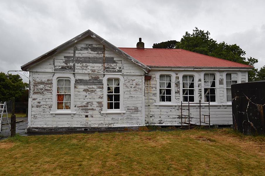
In January 1885 Masterton builder John Montgomery won the tender for Dreyerton School with a contract price of £249. Turnbull’s design for the new school, a modest 394 square feet (36.6 square metres) in size, was a simple single storey timber building comprised of one room with a gable roof, a design typical of rural schools in this period. Surmounting the gabled entrance porch was a small belfry topped with a steeple. The porch had one double-hung eight paned sash window on the north-east elevation with rounded top corners and corbels under the sill, and this was likely replicated on the south-west elevation. The main north-east and south-west elevations each had two of these windows, which were a distinguishing characteristic of Turnbull’s and seen on other Wairarapa schools he designed in the 1880s, including Mauriceville West, Te Whiti, Eketāhuna, Tīnui and Featherston. Tīnui, Featherston and Mauriceville West also had similar porches.
Dreyerton School opened on 20 May 1885, with 19 pupils. By the end of the first quarter there were 22 girls and 25 boys on the roll. As was common practice at the time, girls and boys sat on different sides of the classroom and had separate playgrounds. Small sheds were built in the grounds in 1885 and 1887 to provide the children with shelter during hot or wet weather. Outside of school hours the building was used for events, such as social evenings and election meetings.
In April 1897, after numerous requests by the school committee, the Board agreed to fund an additional classroom to accommodate a growing roll. The contract was let to Masterton builder C. E. Daniell. The new classroom was built at a right angle to the original school room, forming an L shape, and a lean-to kitchen was attached to the front of this alongside the existing porch. Both new additions had double-hung sash windows that mirrored the originals in style. The total addition was 618 square feet (57.4 square metres), and the school was now 1012 square feet (94 square metres) in total.
New Name
By the early 1900s, the settlement’s name was being reconsidered. The school, the post office and church were named Dreyerton but the railway station was called Kopuāranga, as was the survey district in which the township was located, and a nearby river. In mid-1906, at the school committee’s request, the Board changed the name of the school from Dreyerton to Kopuāranga in line with the settlement.
Building Changes
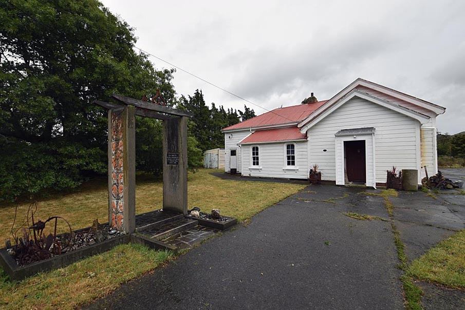
In 1932 new ridging was put on the school’s roof and two years later, C. E. Daniell was contracted to lower the windows in the main school room and move two windows in the south-western wall to the north-western wall to allow more light into the rooms. In celebration of the King George V’s silver jubilee in 1935, commemorative gates were built at the front entrance of the school. Funds for the gates were raised by locals and the fence and posts were built ‘by a dozen men of the district’ at working bees. The official opening was a brief affair due to bad weather but the event was suitably marked by an evening concert and dance at the local hall up the road.
A significant achievement of the 1940s was the installation of electric lighting in 1942. The belfry was damaged in a major earthquake that year and remained in a precarious state until it was dismantled in 1953. Parts from the tower were used to build a milk stand at the front gate.
In 1959, under the supervision of architect H.L. Symmans, the school building was modernised by the addition of a large bank of windows on the north-eastern elevation, which replaced the two original double-hung sash windows and provided plenty of fresh air. The lean-to may also have had sinks and a zip added. In 1960 a free-standing bell tower was built in the grounds to commemorate the school’s 75th anniversary. The original bell from the dismantled belfry had been kept and this was installed in the new tower. During the 1960s a small entrance porch was added to the front original porch.
Closure
The school roll had sat in the mid-20s to mid-30s since the 1920s and struggled to maintain double figures by the 1960s. With such small numbers, the school was particularly vulnerable when rural economic downturn caused families to move out of the district. By early 1970 the school roll stood at eleven pupils and the following year the Wellington Education Board proposed shifting the form one and two pupils to a Masterton intermediate school. This did not eventuate but, in the words of the district’s centennial publication, ‘the writing was on the wall. We knew it – and the Board knew it.’ Kopuāranga School closed on 19 December 1975 and its remaining pupils went to nearby Ōpaki School the following year.
The Kopuāranga Hall Society, which administered both the local hall and a closed church, asked the Ministry of Education for the land and buildings to be classified as a reserve with the society appointed as an administering body. The site was duly classified under the Reserves Act 1977 and the Kopuāranga Hall Society was appointed to ‘control and manage’ the reserve in 1980. The school became the home of the Wairarapa Vintage Car Club and, later, a private residence and artist’s studio. It is now one on a Scandinavian heritage trail devised by the group Friends of Mauriceville.