

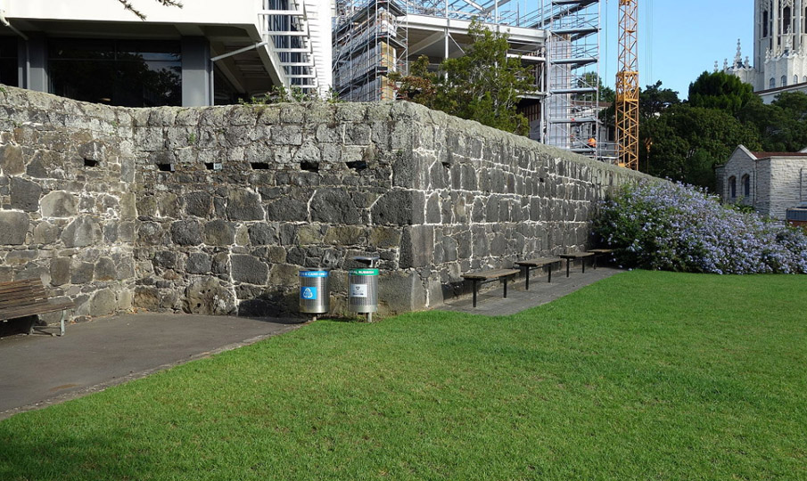
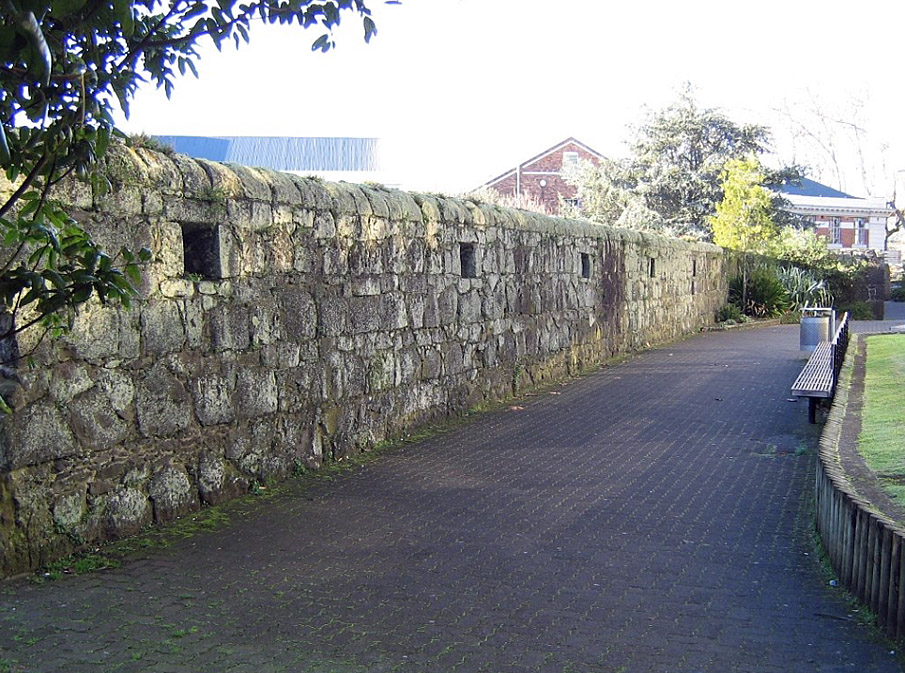
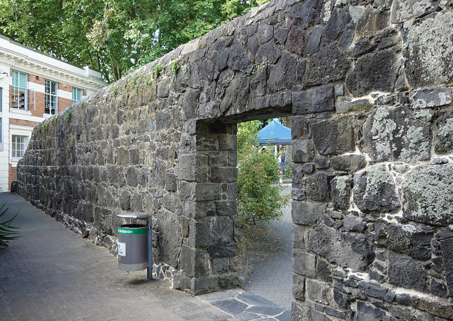
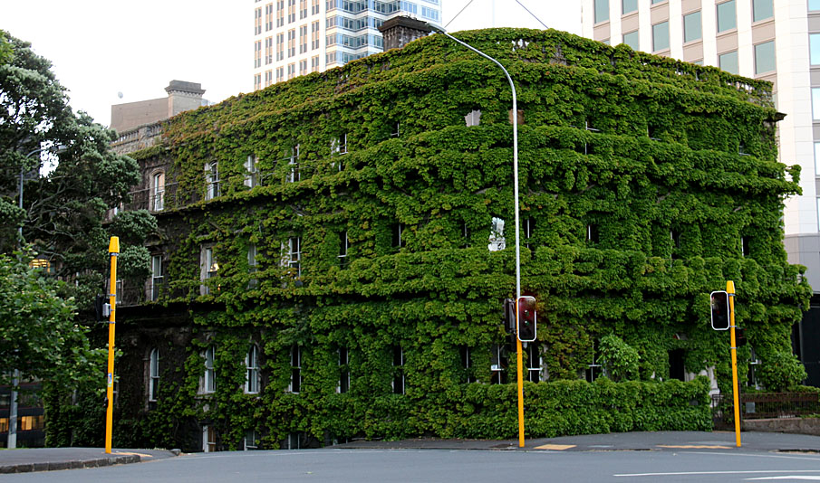
Surviving to a length of some 85 m and to its full original height, the wall is the only standing remnant of the barracks site. It consists of large basalt masonry bonded with lime mortar, and contains small rectangular apertures - gun loops - at regular intervals, including several in a flanking angle to provide flanking fire. Largely dismantled after the barracks were abandoned in 1870, the existing length of wall was retained as a property boundary to the garden of the former Government House. Its recognition as an historic monument had occurred by 1915, when the Auckland Civic League erected a plaque commemorating the contribution made by Maori to its construction. This was installed when many Maori soldiers were fighting alongside Pakeha on behalf of the British Empire in the First World War. A further part of the wall was demolished for the construction of the former University Arts Building in the 1920s, and the plaque damaged during land rights protests fifty years later. It was removed before 1984, when the surviving section of wall was restored by the University of Auckland.
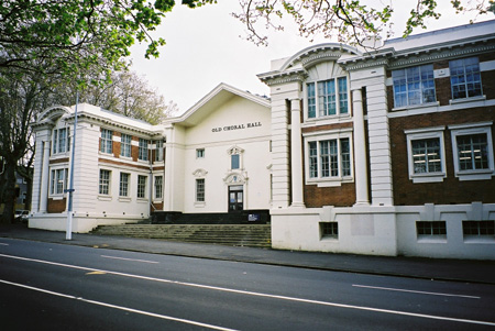
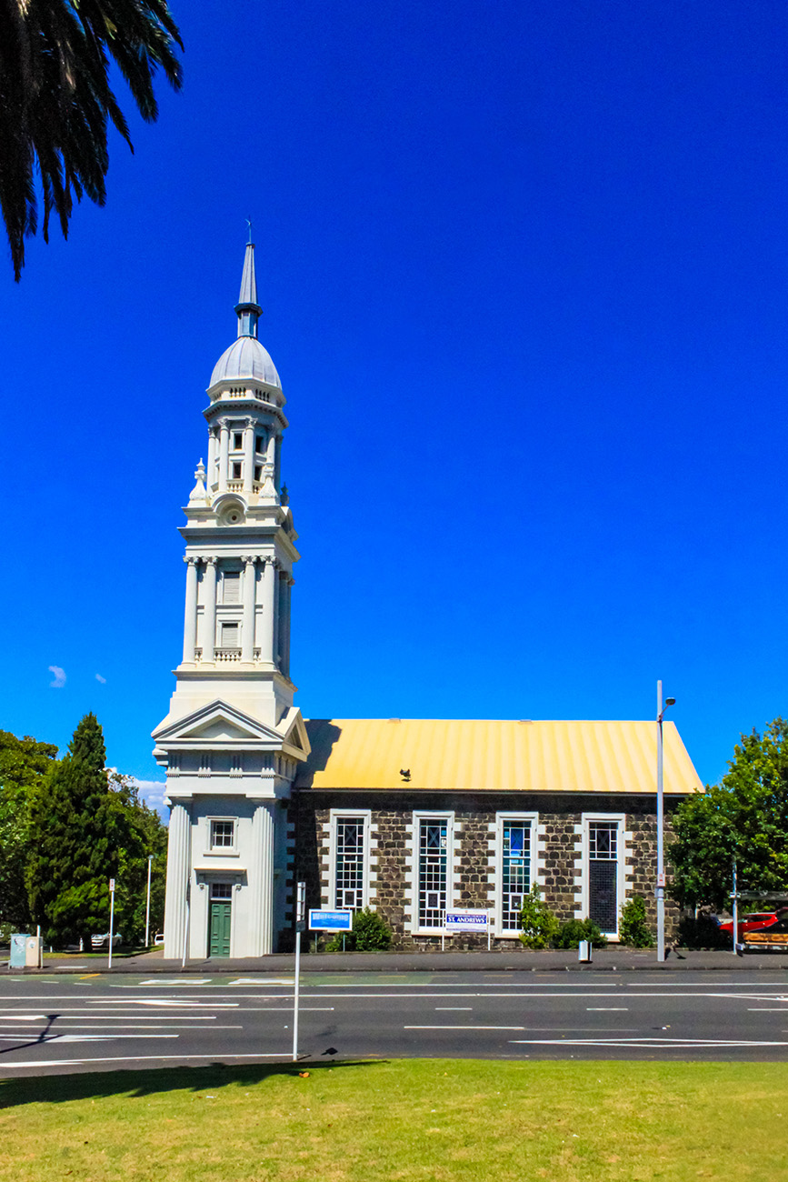
The Albert Barracks Wall has national and international significance as the oldest intact stretch of British military architecture in New Zealand, reflecting mid-nineteenth century ideas on defence and the garrisoning of military personnel. It is an important reminder of the role played by British troops in the colonisation of the country, including their contribution to the economy and social life of the early capital. It is of considerable value for its association with relationships between Maori and Pakeha, both during the early colonial period and in later years. The wall is significant as the oldest stone structure known to survive in central Auckland, and as an early example of a recognised historic monument. The structure is additionally important as part of a wider historical and archaeological landscape, being associated with other early colonial buildings in the Symonds Street and Princes Street area, including St Andrew's Church and the former Government House.
List Entry Information
Status
Listed
List Entry Status
Historic Place Category 1
Access
Able to Visit
List Number
12
Date Entered
23rd June 1983
Date of Effect
23rd June 1983
City/District Council
Auckland Council
Region
Auckland Council
Legal description
Allots 3 9 & 10 Sbrn Sec 2 Sec 13 and Allot 3 Sec 6 City of Auckland
Why is this place significant?
Cultural Significance
The wall has cultural significance as a symbol of Maori/Pakeha relations and early colonial settlement. It has been commemorated through the erection of plaques by successive communities in Auckland and is an early example of a recognised historic monument in New Zealand.
Historic Significance
Historical Significance or Value The Albert Barracks Wall has outstanding significance for its associations with the British Army and the New Zealand Wars, especially the conflicts in Northland and the Waikato. It is a graphic reflection of the role played by the military in the early colonial settlement of New Zealand and the only standing remnant of Albert Barracks, whose garrison was fundamental to the development of Auckland and its surrounding area. It is of great value for its ability to demonstrate relations between Maori and Pakeha during the early colonial period and later. As part of the later boundary to the former Government House, the wall is also associated with the viceregal occupation of the residence and its grounds, which included use by colonial governors and visiting dignitaries, such as Potatau Te Wherowhero (?-1860) and British royalty. Its historical significance is enhanced through its proximity to other early structures, including the former Government House, St Andrew's Church and Old Choral Hall.
Physical Significance
The wall has national and international significance as the oldest length of intact British military architecture in New Zealand. It has considerable architectural and technological value for its ability to demonstrate mid nineteenth-century military technology and building techniques, as well as early colonial ideas on defence and the garrisoning of military personnel. As the oldest known standing masonry structure in central Auckland, it exemplifies the early adaptation of imported methods to local materials. It has substantial archaeological significance, being associated with an extensive barracks site, which still survives beneath Albert Park and elsewhere. It has scientific value for its potential to provide information about early quarrying techniques and the preparation of building materials including lime mortar.
Why is this place Category 1 / Category 2?
Detail Of Assessed Criteria
(a) - The extent to which the place reflects important or representative aspects of New Zealand history: The wall is an important physical reminder of the involvement of the British Army in the early colonisation of New Zealand. It demonstrates a strong link with the colonising process elsewhere in the British Empire, where military power was a component element. It also reflects Auckland's role as a garrison town, where a large military presence stimulated the economic and social development of the capital and its hinterland. The wall reflects the considerable involvement of Maori in the working life of early Auckland, as well as ongoing relations between Maori and Pakeha through to more recent times. (b) The association of the place with events, persons, or ideas of importance in New Zealand history: The wall is associated with a number of prominent events and people in New Zealand history, including the First and Third New Zealand Wars (1844-1845, and 1863-1864), the 58th and 18th Regiments of the British Army, Sir George Grey (1812-1898), and military personalities such as Colonel Robert Wynyard (1802-1864). It has strong connections with personalities of local and regional importance, including the military clerk and early historian, George Graham (1812-1901). It is linked through commemoration to the involvement of New Zealand soldiers in the First World War. (c) The potential of the place to provide knowledge of New Zealand history: The wall provides information about methods of early colonial defence and the garrisoning of military personnel. It also yields information about the organisation of labour in military construction, and the adaptation of overseas ideas to local terrain and materials. The wall is part of a larger archaeological site and historical landscape that potentially provides further evidence about military life in early New Zealand, and the relationship between military and civilian activities in colonial Auckland. (e) The community association with, or public esteem for, the place: The Albert Barracks wall has been recognised as a historic monument over a long period of time. One of its gates was initially earmarked for preservation in the 1870s, while the surviving section has been officially commemorated by local and national organisations since at least the First World War. The organisations involved have included the Auckland Civic League, University of Auckland Senate and New Zealand Historic Places Trust/Pouhere Taonga. (f) The potential of the place for public education: The wall has considerable potential for education as a public monument in the grounds of the University of Auckland. It is a substantial and highly distinctive structure, with potential to provide information about numerous aspects of early colonial life in New Zealand. It has educational value as part of a wider historic urban landscape, which incorporates nearby historic buildings of a similar age. (g) The technical accomplishment or value, or design of the place: The wall is unusual as an intact length of early colonial British military architecture in New Zealand, with considerable architectural and technological value for its ability to demonstrate mid nineteenth-century military technology and building techniques. It is an early example of Maori stonemasonry using Pakeha construction methods, which has remained standing for over 150 years. (h) The symbolic or commemorative value of the place: The structure has high symbolic and commemorative value as a remnant of New Zealand's early colonial past, and its connections with relations between Maori and Pakeha. (i) The importance of identifying historic places known to date from early periods of New Zealand settlement: The wall is the oldest length of intact British military architecture in New Zealand, and is linked to early colonial settlement. It reflects important aspects of early colonial life, and was a fundamental part of the early settlement at Auckland. It is believed to be the oldest surviving standing masonry in central Auckland. (j) The importance of identifying rare types of historic places: The wall is one of few British military fortifications surviving from the early colonial period in New Zealand and, of these, it is the best-preserved. (k) The extent to which the place forms part of a wider historical and cultural complex or historical and cultural landscape: The wall is an important part of a larger historical and archaeological landscape of early colonial date that includes the former Government House, St Andrew's Church and Old Choral Hall. Other parts of the Albert Barracks site survive as buried archaeological remains under Albert Park and elsewhere.
Construction Professional
Name
British Army Royal Engineers
Type
Architect
Biography
No biography is currently available for this construction professional
Construction Details
Type
Modification
Description
Removal of 1915 plaque
Period
pre-1984
Start Year
1846
Finish Year
1852
Type
Original Construction
Description
Construction
Start Year
1873
Finish Year
1875
Type
Modification
Description
Demolition of wall, other than northeast section of fortification
Start Year
1914
startYearCirca
Type
Modification
Description
Breach through surviving section
Start Year
1922
Type
Modification
Description
Erection of plaque commemorating Maori workmen (originally erected on another portion of the wall in 1915)
Start Year
1922
Type
Modification
Description
Further demolition of wall
Start Year
1968
Type
Modification
Description
Breach through surviving section
Start Year
1984
Type
Reconstruction
Description
Restoration of wall, including the blocking of one breach
Construction Materials
Built to courses, with masonry facing and a rubble core. The courses are made of large and irregular basalt blocks quarried from Mt Eden, with smaller basalt infill. All are bonded with lime mortar.
Notable Features
Registration covers the wall, its foundations and fixtures. The structure is associated with buried archaeological features of nineteenth-century date, including a nearby well and drain.
Auckland was the military and administrative capital of New Zealand during the early colonial period (1841-1865), and had a permanent garrison of British soldiers from 1840 to 1870. The earliest barracks were at Fort Britomart, overlooking the harbour to the east of the town, where there was accommodation for roughly 200 men. During the First New Zealand - or Northern - War (1845-1846), many of the troops were removed to the Bay of Islands, causing disquiet among Auckland settlers, who feared a Maori attack. Immediately after the war the Governor, Sir George Grey (1812-1898), took action to reassure the local population by asking the British government to fund the construction of a large stone fortification housing at least 900 troops. He considered that it would protect the wealthiest, and most densely populated portion of the town, and afford a place of refuge for its inhabitants and their property. At this time, roughly 3,600 people lived in Auckland. The site chosen for the barracks lay immediately behind the first Government House, Grey's own residence, on a prominent ridge to the southeast of the town. The ridge was known as Rangipuke, and may have been used for settlement by local Maori. The new fortification - known as Albert Barracks - was designed by military engineers brought out from Britain, and mostly erected by a Maori workforce under the supervision of George Graham, clerk of works for the Royal Engineers. The employment of Maori was an experimental measure, partly caused by a shortage of Pakeha labour, but also because of a belief that indigenous unrest was linked to contemporary notions of 'idleness'. The men received training in quarrying, well-digging and stonemasonry; their skills were praised by local officials and settlers. The barracks was the largest early colonial military fortification built in New Zealand. Work on its defensive perimeter probably began in late 1846 and continued until at least 1850, although permanent gates were not fitted until 1852. The wall enclosed an area of at least 9 hectares, or 22 acres, and was roughly octagonal in plan, with flanking angles. It contained loopholes and a raised banquette for soldiers to stand on when firing, and also held three gates, the northernmost having an inscription - of unknown wording - in Maori. Buildings enclosed within the wall included a hospital, armoury, magazine for the storage of ammunition, offices and accommodation for officers and men. The barracks housed a permanent garrison for nearly 25 years, during which time it retained a prominent martial role. It was also vital to the economy of the town, and the development of its civic life. Buildings inside the barracks were used for prominent events, such as a ball held on Queen Victoria's birthday in 1848, attended by the Maori leader and later king, Potatau Te Wherowhero (?-1860), and Governor George Grey. Similarly, the parade ground was used for some of the earliest cricket matches in the settlement, such as that between military personnel and civilians in 1856. The regular pay of the soldiers was an important stimulus to the economy and when the 58th Regiment departed in 1858 after a dozen years in the barracks, it was claimed that one-seventh of the provincial population of Auckland was drawn from its ranks. During the third New Zealand - or Waikato - War of 1863-1864, the Albert Barracks parade ground was used extensively for the training of local militia. After the colonists' takeover of the Waikato, the British government withdrew its troops and the 18th Regiment finally left the barracks in early 1870. Demolition of much of the wall and internal buildings was carried out in 1873-1875, although it was originally intended that the northern gate, with its Maori inscription, should remain as a memorial. After vigorous public protest, part of the land was set aside for recreation as Albert Park, while the rest was subdivided and sold, largely to wealthy merchants. Only the northeastern stretch of barracks wall survived, probably because it formed the western boundary of Government House. By the First World War, the wall had developed a symbolic meaning, and a plaque was erected during that conflict linking its construction to the collective effort of all New Zealanders in Europe: 'To Commemorate / The Union & Comradeship / of PAKEHA & MAORI / During the Great European War / This Tablet was Fixed by the / AUCKLAND CIVIC LEAGUE / Sept 1915. / On the Remnant of the / BARRACK WALL / Built by Friendly Maoris / in 1848 / After the Burning of Kororareka.' Nevertheless, a further length was demolished in 1922 to allow construction of a new Arts Building for the University of Auckland, while at least two breaches in the surviving stretch were created in 1914-1918 and 1968 for pedestrian access. Disagreements about the sentiments expressed on the First World War plaque led to it being defaced during the land rights protests of the 1970s and 1980s, due to which it was removed. Another plaque, commemorating the barracks as a refuge was erected after 1973, as requested by the University of Auckland Senate and New Zealand Historic Places Trust/Pouhere Taonga. The university, who now owned all the surrounding land, undertook a restoration programme in 1984, rebuilding one breached element of the wall and unblocking a previously bricked up breach.
Auckland was the military and administrative capital of New Zealand during the early colonial period (1841-1865), and had a permanent garrison of British soldiers from 1840 to 1870. The earliest barracks were at Fort Britomart, overlooking the harbour to the east of the town, where there was accommodation for roughly 200 men. During the First New Zealand - or Northern - War (1845-1846), many of the troops were removed to the Bay of Islands, causing disquiet among Auckland settlers, who feared a Maori attack. Immediately after the war the Governor, Sir George Grey (1812-1898), took action to reassure the local population by asking the British government to fund the construction of a large stone fortification housing at least 900 troops. He considered that it would protect the wealthiest, and most densely populated portion of the town, and afford a place of refuge for its inhabitants and their property. At this time, roughly 3,600 people lived in Auckland. The site chosen for the barracks lay immediately behind the first Government House, Grey's own residence, on a prominent ridge to the southeast of the town. The ridge was known as Rangipuke, and may have been used for settlement by local Maori. The new fortification - known as Albert Barracks - was designed by military engineers brought out from Britain, and mostly erected by a Maori workforce under the supervision of George Graham, clerk of works for the Royal Engineers. The employment of Maori was an experimental measure, partly caused by a shortage of Pakeha labour, but also because of a belief that indigenous unrest was linked to contemporary notions of 'idleness'. The men received training in quarrying, well-digging and stonemasonry; their skills were praised by local officials and settlers. The barracks was the largest early colonial military fortification built in New Zealand. Work on its defensive perimeter probably began in late 1846 and continued until at least 1850, although permanent gates were not fitted until 1852. The wall enclosed an area of at least 9 hectares, or 22 acres, and was roughly octagonal in plan, with flanking angles. It contained loopholes and a raised banquette for soldiers to stand on when firing, and also held three gates, the northernmost having an inscription - of unknown wording - in Maori. Buildings enclosed within the wall included a hospital, armoury, magazine for the storage of ammunition, offices and accommodation for officers and men. The barracks housed a permanent garrison for nearly 25 years, during which time it retained a prominent martial role. It was also vital to the economy of the town, and the development of its civic life. Buildings inside the barracks were used for prominent events, such as a ball held on Queen Victoria's birthday in 1848, attended by the Maori leader and later king, Potatau Te Wherowhero (?-1860), and Governor George Grey. Similarly, the parade ground was used for some of the earliest cricket matches in the settlement, such as that between military personnel and civilians in 1856. The regular pay of the soldiers was an important stimulus to the economy and when the 58th Regiment departed in 1858 after a dozen years in the barracks, it was claimed that one-seventh of the provincial population of Auckland was drawn from its ranks. During the third New Zealand - or Waikato - War of 1863-1864, the Albert Barracks parade ground was used extensively for the training of local militia. After the colonists' takeover of the Waikato, the British government withdrew its troops and the 18th Regiment finally left the barracks in early 1870. Demolition of much of the wall and internal buildings was carried out in 1873-1875, although it was originally intended that the northern gate, with its Maori inscription, should remain as a memorial. After vigorous public protest, part of the land was set aside for recreation as Albert Park, while the rest was subdivided and sold, largely to wealthy merchants. Only the northeastern stretch of barracks wall survived, probably because it formed the western boundary of Government House. By the First World War, the wall had developed a symbolic meaning, and a plaque was erected during that conflict linking its construction to the collective effort of all New Zealanders in Europe: 'To Commemorate / The Union & Comradeship / of PAKEHA & MAORI / During the Great European War / This Tablet was Fixed by the / AUCKLAND CIVIC LEAGUE / Sept 1915. / On the Remnant of the / BARRACK WALL / Built by Friendly Maoris / in 1848 / After the Burning of Kororareka.' Nevertheless, a further length was demolished in 1922 to allow construction of a new Arts Building for the University of Auckland, while at least two breaches in the surviving stretch were created in 1914-1918 and 1968 for pedestrian access. Disagreements about the sentiments expressed on the First World War plaque led to it being defaced during the land rights protests of the 1970s and 1980s, due to which it was removed. Another plaque, commemorating the barracks as a refuge was erected after 1973, as requested by the University of Auckland Senate and New Zealand Historic Places Trust/Pouhere Taonga. The university, who now owned all the surrounding land, undertook a restoration programme in 1984, rebuilding one breached element of the wall and unblocking a previously bricked up breach.
The wall is located to the east of the general library of the University of Auckland, which fronts onto Alfred Street. It is roughly 85 m long, and consists of two straight lengths of masonry with a connecting flanking angle 4.7 m long. The stub of another flanking angle survives at its southern end. The wall survives to its full original height, which is up to 3.4 m above ground level on its external side, and is capped with rounded stone coping. Offset footings are visible towards its southern end, suggesting that the external ground in this area was lowered when the Choral Hall was extended in 1919, while the ground surface to the west of the wall is significantly higher throughout. Apart from its footings, the wall is the same width from top to base at 630-660 mm across. A physical examination of the masonry indicates that the surviving stretch may have been built in at least two phases, with the southern portion and lower part of the flanking angle constructed first. The earliest section is rougher in build, with coursing that varies from 540 to 970 mm in height, while the upper part of the flanking angle and northern stretch are significantly more regular, with courses 560 mm and 620 mm high. Differences extend to the disposition of a series of gun loops, which are generally centred about 5.75 m apart in the earlier work, but less than 5.4 m further north. Such variations suggest that the wall was constructed in segments, perhaps by different gangs or seasonally, with improving techniques and different specifications. It may reflect the gathering of expertise by its Maori builders. The gun loops were evidently designed for rifle fire, having a flat base with a sloping top and sides to create narrow, rectangular openings on the external face of the wall. Five loops only about 750 mm apart in the flanking masonry allowed more concentrated fire to be directed along the face of the perimeter wall, while the angle of the flank - at more than 90 degrees - enabled cover to extend as far as the southeastern corner of the fortification. There is no trace of an internal banquette currently visible above ground level. Modifications that reflect later activities include the blocking up of twentieth-century breaches, which have restored the wall to its original appearance apart from one small doorway. Similarly, some discolouration on the external face of the wall at its northern end may be the result of burning from garden activity in the grounds of Government House. There are a number of metal fixtures, including spikes and loops, which are likely to be of various dates and function. Buried features other than the wall foundations are not covered by the registration, but are protected archaeological deposits. They are likely to include a military well and drain immediately to the west of the wall, as well as occupation layers linked to a row of timber barracks, positioned at right angles to the perimeter. Although the ground to the east lay outside the barracks, in a military reserve beside the garden of the former Government House, it may also include material contemporary with the use of the fortification. It is unclear if evidence of earlier, Maori occupation survives, none having been found so far in excavations on the barracks site.
The wall is located to the east of the general library of the University of Auckland, which fronts onto Alfred Street. It is roughly 85 m long, and consists of two straight lengths of masonry with a connecting flanking angle 4.7 m long. The stub of another flanking angle survives at its southern end. The wall survives to its full original height, which is up to 3.4 m above ground level on its external side, and is capped with rounded stone coping. Offset footings are visible towards its southern end, suggesting that the external ground in this area was lowered when the Choral Hall was extended in 1919, while the ground surface to the west of the wall is significantly higher throughout. Apart from its footings, the wall is the same width from top to base at 630-660 mm across. A physical examination of the masonry indicates that the surviving stretch may have been built in at least two phases, with the southern portion and lower part of the flanking angle constructed first. The earliest section is rougher in build, with coursing that varies from 540 to 970 mm in height, while the upper part of the flanking angle and northern stretch are significantly more regular, with courses 560 mm and 620 mm high. Differences extend to the disposition of a series of gun loops, which are generally centred about 5.75 m apart in the earlier work, but less than 5.4 m further north. Such variations suggest that the wall was constructed in segments, perhaps by different gangs or seasonally, with improving techniques and different specifications. It may reflect the gathering of expertise by its Maori builders. The gun loops were evidently designed for rifle fire, having a flat base with a sloping top and sides to create narrow, rectangular openings on the external face of the wall. Five loops only about 750 mm apart in the flanking masonry allowed more concentrated fire to be directed along the face of the perimeter wall, while the angle of the flank - at more than 90 degrees - enabled cover to extend as far as the southeastern corner of the fortification. There is no trace of an internal banquette currently visible above ground level. Modifications that reflect later activities include the blocking up of twentieth-century breaches, which have restored the wall to its original appearance apart from one small doorway. Similarly, some discolouration on the external face of the wall at its northern end may be the result of burning from garden activity in the grounds of Government House. There are a number of metal fixtures, including spikes and loops, which are likely to be of various dates and function. Buried features other than the wall foundations are not covered by the registration, but are protected archaeological deposits. They are likely to include a military well and drain immediately to the west of the wall, as well as occupation layers linked to a row of timber barracks, positioned at right angles to the perimeter. Although the ground to the east lay outside the barracks, in a military reserve beside the garden of the former Government House, it may also include material contemporary with the use of the fortification. It is unclear if evidence of earlier, Maori occupation survives, none having been found so far in excavations on the barracks site.
Historical and Associated Iwi / Hapū / Whānau
Completion Date
21st August 2001
Report Written By
Martin Jones
Information Sources
Adams, 1973
P. Adams, 'Albert Barracks Wall', NZHPT report, Auckland, 1973 (held by NZHPT, Auckland)
Anon nd
Anon.
Coates, 1990
Jan Coates, 'Bluestone and Bureaucracy. A project on the presentation of an archaeological site: Albert Barracks R11/833', Science and Research Internal Report No. 65, Department of Conservation, Wellington, 1990
Platts, 1971
Una Platts, The Lively Capital: Auckland 1840-1865, Christchurch, 1971
Smith, 1989
Ian Smith, 'Rediscovering Fort Ligar: Archaeology at R11/1656, Auckland. Volume 1: Excavation and Site History', Department of Conservation Science and Research Internal Report No. 40, Wellington, 1989
Conservation Plan
Conservation Plan
Journal of the Auckland Historical Society
Journal of the Auckland Historical Society
Other Information
Please note that entry on the New Zealand Heritage List/Rarangi Korero identifies only the heritage values of the property concerned, and should not be construed as advice on the state of the property, or as a comment of its soundness or safety, including in regard to earthquake risk, safety in the event of fire, or insanitary conditions.
Current Usages
Uses: Commemoration
Specific Usage: Monuments, memorial, site of particular event - other
Former Usages
General Usage: Civic Facilities
Specific Usage: Wall/Fence
General Usage: Commemoration
Specific Usage: Memorial - Particular person or group
Current Usages
Uses: Commemoration
Specific Usage: Monuments, memorial, site of particular event - other
Former Usages
General Usage: Civic Facilities
Specific Usage: Wall/Fence
General Usage: Commemoration
Specific Usage: Memorial - Particular person or group
Location
Related listings
Sign up to hear more
Get the latest heritage news, features and events delivered
straight to your inbox.
