

Marlborough is directly associated with the earliest period of Māori settlement in Aotearoa. Polynesian settlers inhabited Te Pokohiwi/Wairau Bar c.1300, and an extensive network of lagoons was later developed to make the most of the plentiful mahinga kai resources. Earlier tribes were succeeded by Ngāti Kuia, Ngāti Apa and Rangitāne in the sixteenth century. Between 1828-1832 war parties of Waikato and Taranaki warriors attacked numerous pā, unsettling the region’s established tribal alliances. Ngāti Toa Rangatira put down roots in the Wairau and one of their warrior chiefs, Te Rauparaha, was the primary negotiator for the New Zealand Company’s 1839 purchase of the arable Wairau Valley. European settlement in the nineteenth century shifted customary ways of life for tangata whenua. Ownership and possession of the Wairau was still in dispute until 1847, when the Crown finally wrested legal title. Today Rangitāne o Wairau, Ngāti Rārua and Ngāti Toa Rangatira have principal interests in the Wairau/Blenheim area.
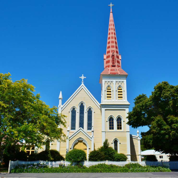
The colonial township of Blenheim developed in the 1850s in an area that was a flax swamp before earthquakes raised the ground level. By 1864 it was the principal town in the province, with a steadily growing Catholic population. Father Augustine Sauzeau SM, appointed Parish Priest that year, is considered the founder of the Catholic Parish of St Mary in Marlborough. He arranged construction of the first St Mary’s Church on a large site in Blenheim’s Maxwell Road in 1865, and a complex of buildings that ultimately included two primary schools, an infant school, parish hall, presbytery, convent and high school, grew around the church, which was replaced with a larger building in 1878. Sauzeau first lived in a small cottage until a new presbytery was built at the south of St Mary’s Church, near Dillon Street, in the 1870s. By the late 1880s the parochial residence required upgrading.
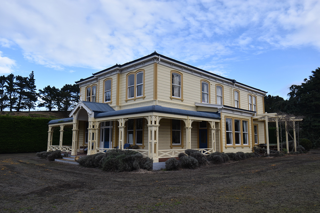
The front of the 1870s building was demolished and in 1891 architect D.A. Douglas’s substantial two-storeyed timber addition for the presbytery was completed. Containing large sitting rooms and a library with generous bedrooms above, the building’s ‘strikingly handsome’ street-frontage and particularly notable verandah and portico dates from this period, as does the impressive entrance hall, with stained glass door, varnished timber panelling and ornamental archway above a turned staircase.
Twenty years later the rear half of the building was replaced by a substantial addition designed by John Sydney Swan. This contained a new kitchen, lounge and housekeepers flat with more bedrooms and bathroom above, and a striking skylight stylistically linked to Swan’s work on the Maxwell Road convent.
A small extension to one of the lounges was made in the mid-twentieth century. However, in 1996 the presbytery underwent its most substantial alteration when it was sold for disposal in the major redevelopment of the Maxwell Road parish complex. The presbytery was relocated in six sections to a rural site near Seddon, where it was reassembled and continues to function successfully as a comfortable residence, little altered from its original periods of construction.
List Entry Information
Status
Listed
List Entry Status
Historic Place Category 2
Access
Private/No Public Access
List Number
1532
Date Entered
25th November 1982
Date of Effect
26th January 2023
City/District Council
Marlborough District
Region
Marlborough Region
Extent of List Entry
Extent includes part of the land described as Sec 18 Blk XI Clifford Bay SD (RT MB4C/1043), Marlborough Land District, and the building known as St Mary’s Church Presbytery (Former) thereon.
Legal description
Sec 18 Blk XI Clifford Bay SD (RT MB4C/1043), Marlborough Land District
Location Description
The Presbytery was formerly located near 57 Maxwell Road, to the south of St Mary’s Church, before being relocated to 671-673 Seaview Road, near Seddon. GPS Information (NZTM) – current location: Presbytery: E1692902; N5389644
Why is this place significant?
Historic Significance
Historical Significance or Value The building has historical value as an artefact of the development of Catholicism in Marlborough. It represents two stages of building improvements (in 1891 and 1911) when the growth of St Mary’s Parish required expanded accommodation for multiple Marist priests, which was also of suitable comfort for visiting clergy such as Archbishop Francis Redwood SM.
Physical Significance
Aesthetic Significance or Value The former presbytery’s aesthetic value derives from the symmetry of its Italianate façade and ornamental verandah and entrance portico. Described as ‘strikingly handsome’ when in its original urban location, the building’s scale and design was impressive enough to hold its own against the significant street presence of its former neighbour, St Mary’s Church. It benefits from its new rural setting and retains some impact against the backdrop of its scenic landscape. It has successfully transitioned to stately country house. Architectural Significance or Value The former St Mary’s Presbytery has architectural value as a representative and largely intact example of Italianate architecture, with characteristic fenestration, joinery, symmetry and street presence. Its construction quality is demonstrated by its successful relocation and high-quality materials still fit for modern living without much alteration. Although it has lost integrity through its removal from its original spatial relationship with St Mary’s Church and St Joseph’s Convent (with which it is stylistically linked), the building remains highly authentic due to the small amount of change to its fabric. It is still credible as a former parochial residence from the turn of the nineteenth century.
Why is this place Category 1 / Category 2?
Detail Of Assessed Criteria
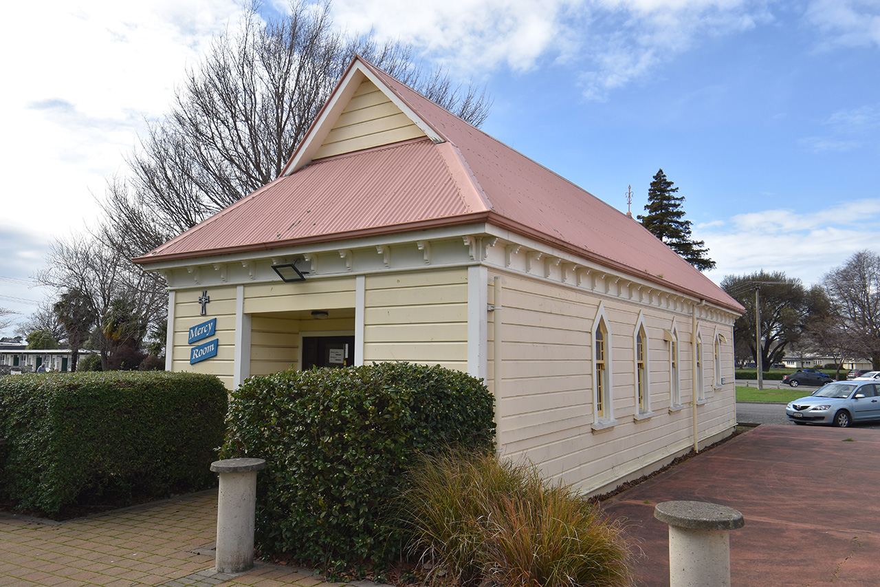
This place was assessed against the Section 66(3) criteria and found to qualify under the following criteria: a, b, g. The assessment concludes that this place should be listed as a Category 2 historic place. (a) The extent to which the place reflects important or representative aspects of New Zealand history The former presbytery represents the growth of Blenheim and the Marlborough province, and the expansion of the Catholic faith there. With the large influx of immigrants to New Zealand in the 1850s the Society of Mary’s work grew from its original pastoral mission for Māori begun in 1838 to a ministry catering for the spiritual needs of colonial Pākehā. (b) The association of the place with events, persons, or ideas of importance in New Zealand history The former presbytery reflects the importance of spiritual practice and organised religion – specifically Catholicism – in New Zealand society. Accommodating the clergy was essential to the functioning of Catholic parishes. Priests often had to travel around a wide district, and appropriate housing was a mark of respect for these ‘fathers of the community’. The association with its former use as a presbytery remains legible due to the intactness and authenticity of the building, and it is part of the landscape of John Sydney Swan’s significant contribution to the architecture of the Catholic Church in New Zealand. (g) The technical accomplishment, value, or design of the place The imposing size and symmetrical Italianate street-frontage, including central entrance porch and decorative verandah, once clearly marked this building as a representative element of the historical Catholic precinct on Maxwell Road, flanking St Mary’s Church as a counterpart to St Joseph’s Convent. Despite having lost its locational relationship to this original context, the former presbytery retains authentic stylistic links with the former St Joseph’s Convent chapel, now renamed the Mercy Room, which remains on its original site. Common characteristics include John Sydney Swan’s work on both buildings employing a shared design language, particularly the presbytery skylight and the Mercy Room’s entrance doors. It reflects Swan’s architectural impact on the Catholic Archdiocese of Wellington, for whom he did a large body of work. The capaciousness and high-quality finishes of the presbytery reflects the status of priests within the parish hierarchy, and its intactness means it is easy to imagine the lifestyles of its former inhabitants. Summary of Significance or Values The former St Mary’s Presbytery has historical value for its association with the expansion of Catholicism in Marlborough as the colonial population grew. The building has architectural value for its authenticity and intactness as a representative example of Italianate domestic architecture that reflects the status of its former clergy inhabitants, the priests’ lifestyles still readable in its structure. The building’s heritage values have undoubtedly been negatively affected by the loss of its original context as an important element amongst what was once a very strong wider historical and cultural area in the complex of buildings surrounding St Mary’s Church on Maxwell Road. However, it is considered that the remaining heritage values are sufficient to meet the threshold for entry on the New Zealand Heritage List/Rārangi Kōrero.
Why is this place significant?
Historic Significance
Historical Significance or Value The building has historical value as an artefact of the development of Catholicism in Marlborough. It represents two stages of building improvements (in 1891 and 1911) when the growth of St Mary’s Parish required expanded accommodation for multiple Marist priests, which was also of suitable comfort for visiting clergy such as Archbishop Francis Redwood SM.
Physical Significance
Aesthetic Significance or Value The former presbytery’s aesthetic value derives from the symmetry of its Italianate façade and ornamental verandah and entrance portico. Described as ‘strikingly handsome’ when in its original urban location, the building’s scale and design was impressive enough to hold its own against the significant street presence of its former neighbour, St Mary’s Church. It benefits from its new rural setting and retains some impact against the backdrop of its scenic landscape. It has successfully transitioned to stately country house. Architectural Significance or Value The former St Mary’s Presbytery has architectural value as a representative and largely intact example of Italianate architecture, with characteristic fenestration, joinery, symmetry and street presence. Its construction quality is demonstrated by its successful relocation and high-quality materials still fit for modern living without much alteration. Although it has lost integrity through its removal from its original spatial relationship with St Mary’s Church and St Joseph’s Convent (with which it is stylistically linked), the building remains highly authentic due to the small amount of change to its fabric. It is still credible as a former parochial residence from the turn of the nineteenth century.
Why is this place Category 1 / Category 2?
Detail Of Assessed Criteria
This place was assessed against the Section 66(3) criteria and found to qualify under the following criteria: a, b, g. The assessment concludes that this place should be listed as a Category 2 historic place. (a) The extent to which the place reflects important or representative aspects of New Zealand history The former presbytery represents the growth of Blenheim and the Marlborough province, and the expansion of the Catholic faith there. With the large influx of immigrants to New Zealand in the 1850s the Society of Mary’s work grew from its original pastoral mission for Māori begun in 1838 to a ministry catering for the spiritual needs of colonial Pākehā. (b) The association of the place with events, persons, or ideas of importance in New Zealand history The former presbytery reflects the importance of spiritual practice and organised religion – specifically Catholicism – in New Zealand society. Accommodating the clergy was essential to the functioning of Catholic parishes. Priests often had to travel around a wide district, and appropriate housing was a mark of respect for these ‘fathers of the community’. The association with its former use as a presbytery remains legible due to the intactness and authenticity of the building, and it is part of the landscape of John Sydney Swan’s significant contribution to the architecture of the Catholic Church in New Zealand. (g) The technical accomplishment, value, or design of the place The imposing size and symmetrical Italianate street-frontage, including central entrance porch and decorative verandah, once clearly marked this building as a representative element of the historical Catholic precinct on Maxwell Road, flanking St Mary’s Church as a counterpart to St Joseph’s Convent. Despite having lost its locational relationship to this original context, the former presbytery retains authentic stylistic links with the former St Joseph’s Convent chapel, now renamed the Mercy Room, which remains on its original site. Common characteristics include John Sydney Swan’s work on both buildings employing a shared design language, particularly the presbytery skylight and the Mercy Room’s entrance doors. It reflects Swan’s architectural impact on the Catholic Archdiocese of Wellington, for whom he did a large body of work. The capaciousness and high-quality finishes of the presbytery reflects the status of priests within the parish hierarchy, and its intactness means it is easy to imagine the lifestyles of its former inhabitants. Summary of Significance or Values The former St Mary’s Presbytery has historical value for its association with the expansion of Catholicism in Marlborough as the colonial population grew. The building has architectural value for its authenticity and intactness as a representative example of Italianate domestic architecture that reflects the status of its former clergy inhabitants, the priests’ lifestyles still readable in its structure. The building’s heritage values have undoubtedly been negatively affected by the loss of its original context as an important element amongst what was once a very strong wider historical and cultural area in the complex of buildings surrounding St Mary’s Church on Maxwell Road. However, it is considered that the remaining heritage values are sufficient to meet the threshold for entry on the New Zealand Heritage List/Rārangi Kōrero.
Construction Professional
Name
Sir Michael Fowler
Type
Architect
Biography
Name
D.A. Douglas
Type
Architect
Biography
Name
R. Jones
Type
Builder
Biography
Name
Swan, John Sydney
Type
Architect
Biography
Swan (1874-1936) practised architecture during the late nineteenth and early twentieth centuries. He formed part of the last group of architects to follow the traditional Gothic and Classical styles. He was articled to Frederick de Jersey Clere, working with Clere on many major designs such as the Wellington Rowing Club building (then known as the Naval Artillery Boat Shed, 1894) as well as smaller provincial buildings such as the Church of the Good Shepherd, Tinui. The firm was known as Clere, Fitzgerald and Richmond and was one of the most prominent architectural practices in Wellington. From 1901 to 1906 Swan was in partnership with Clere, practising on his own account from 1907. The first major design produced by Swan in this new practice was the Karori Crematorium (1907) which served to establish his architectural identity separate from Clere. During his long and varied career Swan produced a large and wide range of work, including a number of banks for the National Bank such as the head office building in Wellington (1907), educational buildings for the Wellington Technical College with William Gray Young (1922), and a number of major buildings for the Catholic Church including St Gerard's Church, Mt Victoria (1910), Sacred Heart Convent (later Erskine College), Island Bay (1909), and Wanganui Convent (1912). He was an architect of imagination as evidenced by the design of his own house 'The Moorings', Glenbervie Terrace (1905).
Construction Details
Start Year
1891
Type
Partial Demolition
Description
Part of original building removed and replaced with an addition to the ‘front’ consisting of two-storey building with verandah and entrance porch, containing living rooms on ground floor and bedrooms and bathrooms on the first floor, accessed by timber stairs and 8-foot wide hallway.
Start Year
1911
Type
Partial Demolition
Description
Demolition of remaining original building, replaced with a two-storeyed addition to the ‘rear’ of the building, containing three bedrooms, a bathroom and office on the top floor, and kitchen and housekeeper’s flat on the ground floor.
Start Year
1960
startYearCirca
Finish Year
1964
Type
Addition
Description
Community Room’ lounge enlarged by enclosing verandah. 1997 / Relocation / Chimneys dismantled and entire building moved in six sections to 671 Seaview Road, Seddon.
Start Year
1997
startYearCirca
Finish Year
1998
Type
Reconstruction
Description
Building reassembled on new foundations (including new cellar); new ensuite created; new kitchen fixtures installed
Construction Materials
Timber, corrugated steel, glass
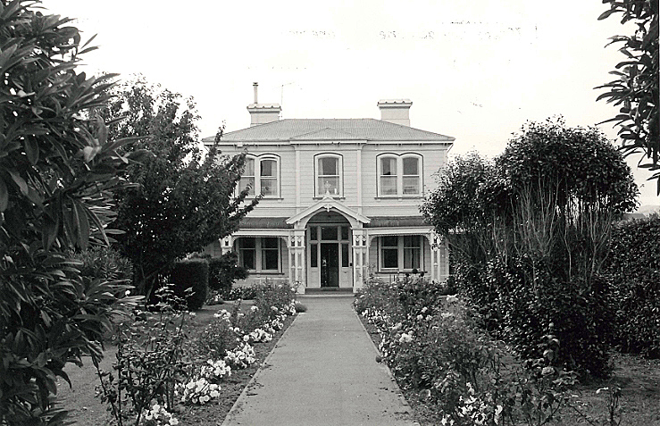
Historical Information The northern South Island is known as Te Tau Ihu, the prow of the waka from which the demigod Māui fished up the North Island. Marlborough is strongly associated with the earliest period of settlement in Aotearoa. Early Polynesian settlers—migrants from Hawaiki in East Polynesia—inhabited Te Pokohiwi/the Wairau Bar in the thirteenth century. Successive migrations of people were drawn to the region’s rich resources. Earlier tribes were largely displaced by Ngāti Kuia and Ngāti Mamoe in the sixteenth century, with Ngāti Mamoe dominating the Wairau. Later in the century, groups of Rangitāne moved southwards from the Hawke’s Bay via Wairarapa, while Ngāti Apa migrated across from the Rangitīkei district. Rangitāne eventually consolidated their position in the Wairau and in the 1700s created an 18-kilometre network of channels amongst the estuarine coastal lagoons. This massive engineering feat served them to harness the already plentiful mahinga kai resources, including fish, eels and birds. In the 1820s a whaling industry centred on Cook Strait was established, with Māori working, trading and intermarrying with Pākehā whalers at shore whaling stations in the Marlborough region. Between 1828-1832 the settled alliances of the region were unbalanced when a war party of Kawhia and Taranaki warriors armed with muskets attacked numerous pā. This caused great losses among the local populations, especially Rangitāne and Ngāti Apa. Ngāti Toa Rangatira put down roots in the Wairau and one of their warrior chiefs, Te Rauparaha, dominated affairs in the region; Ngāti Rārua also settled along the Wairau River. In October 1839 it was primarily with Ngāti Toa that William Wakefield negotiated to purchase large tracts of land for the New Zealand Company, who needed the rural arable pastures of the Wairau Valley to support their colony at Nelson. Ownership and possession of the Wairau was still in dispute in 1842 when the New Zealand Company persisted with surveying the valley, despite Te Tau Ihu chiefs’ denial of Ngāti Toa’s claims to the area, and Te Rauparaha’s insistence that the Wairau land was excluded from the Company’s purchase. The unrest erupted into violence on 17 June 1843, when a posse of settlers tried to arrest Te Rauparaha and his nephew Te Rangihaeata in retaliation for their disruption of the surveying. The confused fighting resulted in the deaths of around 25 people, including victims from both groups. Shockwaves from this tragedy, today referred to as the ‘Wairau Incident’, were felt locally and nationally, and attempts to secure the Wairau slowed until after Commissioner Spain’s 1845 inquiry into the land claims of the Nelson area found that the Wairau District had not been included in the 1839 sale. By various devious and underhand coercive tactics the Crown finally wrested possession of the Wairau from Ngāti Toa in 1847, and the valley was divided into allotments. The 2008 Waitangi Tribunal inquiry report, and subsequent Treaty of Waitangi settlements, acknowledged the Crown’s failure to protect iwi rights and interests in its methods of acquisition of Wairau land and failure to provide adequate reserve lands, among other breaches. Today Rangitāne o Wairau, Ngāti Rārua and Ngāti Toa Rangatira have principal interests in the Wairau/Blenheim area. Blenheim emerges from the wetlands The name of the region’s major river, ‘Wairau’, derives from ‘Ngā wai-rau o Ruatere’, describing the braided waterways across the region, highly important to Māori for providing food and resources such as flax as well as a communication/transport network. The large flax swamp at the convergence of the Ōpaoa and Omaka rivers was described by the area’s Māori name, Te Waiharakeke. This wetland, the future site of Blenheim, also inspired that settlement’s first European name, ‘The Beaver’, said to have been coined by Joseph Ward (1817-1892) when he came across his surveying party ‘[sitting] like a lot of beavers in a dam’ amidst floodwaters. Blenheim developed in the 1850s. Earthquakes in 1848 and 1855 gave the future settlement a boost (literally and figuratively) as the ground level dropped enough to allow sea-going vessels to sail up the river to the site, increasing its potential as a trading nexus. Merchant James Wynen built a raupo warehouse there sometime soon after 1848. In 1852, James Sinclair and his family became the first to permanently reside there. From 1857 Sinclair was the land agent who marketed the town sections. By 1865 Blenheim was the principal town in the province, with a steadily growing population. Catholicism in Blenheim Catholicism in Aotearoa New Zealand grew from the work of missionaries who arrived in Northland in 1838. Bishop Jean-Baptiste Francois Pompallier’s mission was notable for its efforts to form Catholic belief around existing Māori tikanga and disseminate teachings by printing books in the Māori language. The Māori name for Catholicism, ‘Pikopō’ (from ‘episcopal’, meaning ‘of a bishop’), reflects Pompallier’s impact. The missionaries established the Society of Mary’s work in Aotearoa. In 1850 a split between Pompallier and the Society of Mary led to the creation of the Diocese of Wellington, which became the base of the Marist clergy, and included Blenheim. In 1844 the first Catholic missionary visited Marlborough. Father Antoine Garin (1810-1889) was the first Parish Priest, appointed in 1850. However, Father Augustine Sauzeau SM (1834-1898), appointed Marlborough’s Parish Priest in 1864, is considered the founder of the Parish of St Mary. Sauzeau built the first St Mary’s Church on a large site in Blenheim’s Maxwell Road, opened on 26 September 1865. The Blenheim church was part of Sauzeau’s program to establish Catholic facilities in the Marlborough region; the same year he opened the first Catholic School on the Blenheim site. By 1876 a new, larger building was needed to replace the old church. Sauzeau engaged prominent Wellington architect Thomas Turnbull, who designed a substantial timber Gothic building. The new church was opened on 29 September 1878. The first St Mary’s church building was then used as a girls’ school until 1909, then a meeting room until its demolition in 1926. Housing the Clergy: the Presbytery The parishioners originally housed Father Sauzeau in a small cottage across Maxwell Road from the present St Mary’s church. After a few years Sauzeau built a new presbytery further along Maxwell Road, across from Dillon Street. This was said to have been ‘in the old style—gabled roofs and very nearly perpendicular staircases.’ By the mid-1880s this building needed enlarging. Father W.J. Lewis arranged to add a new front section whilst retaining part of the original building at the rear for ‘visitors, servants and kitchen’. Architect D.A. Douglas called for construction tenders in June 1890. A month later the successful contractor—Mr Jones of Havelock—had commenced dismantling the front portion of the house, and by 26 October the site was ready for the Mayor to lay the foundation stone, installing a time capsule. Construction of the enlarged presbytery was completed by March 1891, in timber. At the time the ground floor layout was described as having a parlour, sitting room, dining room and library, with an 8-foot wide hallway running through the building; upstairs contained another sitting room, four bedrooms and a bathroom. The ‘strikingly handsome’ front elevation in existence today [2022] dates from this time. Further substantial alterations were completed in 1911, orchestrated by Father J. Holley. Notable Wellington architect John Sydney Swan’s design replaced the original 1870s rear part of the building with a two-storeyed addition containing three bedrooms, a bathroom and office on the top floor, with kitchen and housekeeper’s flat on the ground floor. The 1891 addition remained at the front, demarcated by the stairway. Swan was, at the time, amidst a series of significant commissions for the Catholic Church in New Zealand, which ultimately included Erskine College, St Gerard’s Church, Our Lady of Compassion Convent in Wellington, Sacred Heart Convent in Whanganui, and St Bede’s School in Christchurch. Two years before his work on the St Mary’s Presbytery he had designed a large addition, including a chapel, for its neighbour on Maxwell Road, St Joseph’s Convent. Property review 1988-1998: dispersal of the Presbytery and Convent In the late 1980s the Parish Pastoral Council and Parish Priest Father Michael O’Hagan commissioned a wide-ranging review of parish property assets. The goal was to reorganise and concentrate resources on revitalising key assets for the future ‘Beyond 2000’; a result was the rationalising of some of the ageing buildings to raise capital. A scheme for a reordered parish centre on Maxwell Road was devised by architects Calder, Fowler, Styles and Turner, involving major alterations and additions to the church, and construction of a new administration block, hall and presbytery. Despite having been heritage-listed since 1982, the historic presbytery, along with the historic former convent, convent high school building and music room, were earmarked for disposal. Other properties were sold, and some school buildings demolished and rebuilt. A new life for the old building In 1996 the old presbytery building was sold to Chris and Trish Redwood and relocated in six sections to the Seddon side of the Awatere River at Seaview. The relocation and rejoining of the building to make it weatherproof apparently took nine days. It was left to settle for two years before the restoration process began following Sir Michael Fowler’s plans, with little change to the building except the installation of an ensuite and new kitchen fixtures. Chimneys were not reinstated but the fireplace surrounds were left in situ. The building was able to be shifted with the verandah intact, so it retains this original and prominent feature of the 1891 façade. With little alteration since its days as a presbytery, the building continues to serve as the comfortable family home for the Redwoods, whose ancestor Archbishop Francis Redwood (1939-1935) would have likely stayed in the residence on his visits to Blenheim. Archbishop Redwood, the first Roman Catholic Archbishop of the Wellington Archdiocese and one of New Zealand’s longest-serving bishops, is considered a ‘Catholic pioneer’ who contributed much to New Zealand history through his support for the establishment of Catholic facilities and the local missions of the Society of Mary, Sisters of Mercy, Sisters of Compassion, and related orders. Sir Michael Fowler’s vision for the Maxwell Road Catholic station was fully enacted and St Mary’s Church continues to be its centre, albeit now surrounded by mostly modern buildings, including the attached foyer, Community Centre, new presbytery and administration building. The St Mary’s school buildings have also been modernised to replace the older buildings. The church itself, and the former convent chapel/Mercy Room, are now the oldest buildings on the site. The parish, now known as the Star of the Sea Marlborough (Te Whetu o Te Moana), is grappling with updated seismic strengthening requirements for the St Mary’s Church building and is undertaking another review of parish properties.
Historical Information The northern South Island is known as Te Tau Ihu, the prow of the waka from which the demigod Māui fished up the North Island. Marlborough is strongly associated with the earliest period of settlement in Aotearoa. Early Polynesian settlers—migrants from Hawaiki in East Polynesia—inhabited Te Pokohiwi/the Wairau Bar in the thirteenth century. Successive migrations of people were drawn to the region’s rich resources. Earlier tribes were largely displaced by Ngāti Kuia and Ngāti Mamoe in the sixteenth century, with Ngāti Mamoe dominating the Wairau. Later in the century, groups of Rangitāne moved southwards from the Hawke’s Bay via Wairarapa, while Ngāti Apa migrated across from the Rangitīkei district. Rangitāne eventually consolidated their position in the Wairau and in the 1700s created an 18-kilometre network of channels amongst the estuarine coastal lagoons. This massive engineering feat served them to harness the already plentiful mahinga kai resources, including fish, eels and birds. In the 1820s a whaling industry centred on Cook Strait was established, with Māori working, trading and intermarrying with Pākehā whalers at shore whaling stations in the Marlborough region. Between 1828-1832 the settled alliances of the region were unbalanced when a war party of Kawhia and Taranaki warriors armed with muskets attacked numerous pā. This caused great losses among the local populations, especially Rangitāne and Ngāti Apa. Ngāti Toa Rangatira put down roots in the Wairau and one of their warrior chiefs, Te Rauparaha, dominated affairs in the region; Ngāti Rārua also settled along the Wairau River. In October 1839 it was primarily with Ngāti Toa that William Wakefield negotiated to purchase large tracts of land for the New Zealand Company, who needed the rural arable pastures of the Wairau Valley to support their colony at Nelson. Ownership and possession of the Wairau was still in dispute in 1842 when the New Zealand Company persisted with surveying the valley, despite Te Tau Ihu chiefs’ denial of Ngāti Toa’s claims to the area, and Te Rauparaha’s insistence that the Wairau land was excluded from the Company’s purchase. The unrest erupted into violence on 17 June 1843, when a posse of settlers tried to arrest Te Rauparaha and his nephew Te Rangihaeata in retaliation for their disruption of the surveying. The confused fighting resulted in the deaths of around 25 people, including victims from both groups. Shockwaves from this tragedy, today referred to as the ‘Wairau Incident’, were felt locally and nationally, and attempts to secure the Wairau slowed until after Commissioner Spain’s 1845 inquiry into the land claims of the Nelson area found that the Wairau District had not been included in the 1839 sale. By various devious and underhand coercive tactics the Crown finally wrested possession of the Wairau from Ngāti Toa in 1847, and the valley was divided into allotments. The 2008 Waitangi Tribunal inquiry report, and subsequent Treaty of Waitangi settlements, acknowledged the Crown’s failure to protect iwi rights and interests in its methods of acquisition of Wairau land and failure to provide adequate reserve lands, among other breaches. Today Rangitāne o Wairau, Ngāti Rārua and Ngāti Toa Rangatira have principal interests in the Wairau/Blenheim area. Blenheim emerges from the wetlands The name of the region’s major river, ‘Wairau’, derives from ‘Ngā wai-rau o Ruatere’, describing the braided waterways across the region, highly important to Māori for providing food and resources such as flax as well as a communication/transport network. The large flax swamp at the convergence of the Ōpaoa and Omaka rivers was described by the area’s Māori name, Te Waiharakeke. This wetland, the future site of Blenheim, also inspired that settlement’s first European name, ‘The Beaver’, said to have been coined by Joseph Ward (1817-1892) when he came across his surveying party ‘[sitting] like a lot of beavers in a dam’ amidst floodwaters. Blenheim developed in the 1850s. Earthquakes in 1848 and 1855 gave the future settlement a boost (literally and figuratively) as the ground level dropped enough to allow sea-going vessels to sail up the river to the site, increasing its potential as a trading nexus. Merchant James Wynen built a raupo warehouse there sometime soon after 1848. In 1852, James Sinclair and his family became the first to permanently reside there. From 1857 Sinclair was the land agent who marketed the town sections. By 1865 Blenheim was the principal town in the province, with a steadily growing population. Catholicism in Blenheim Catholicism in Aotearoa New Zealand grew from the work of missionaries who arrived in Northland in 1838. Bishop Jean-Baptiste Francois Pompallier’s mission was notable for its efforts to form Catholic belief around existing Māori tikanga and disseminate teachings by printing books in the Māori language. The Māori name for Catholicism, ‘Pikopō’ (from ‘episcopal’, meaning ‘of a bishop’), reflects Pompallier’s impact. The missionaries established the Society of Mary’s work in Aotearoa. In 1850 a split between Pompallier and the Society of Mary led to the creation of the Diocese of Wellington, which became the base of the Marist clergy, and included Blenheim. In 1844 the first Catholic missionary visited Marlborough. Father Antoine Garin (1810-1889) was the first Parish Priest, appointed in 1850. However, Father Augustine Sauzeau SM (1834-1898), appointed Marlborough’s Parish Priest in 1864, is considered the founder of the Parish of St Mary. Sauzeau built the first St Mary’s Church on a large site in Blenheim’s Maxwell Road, opened on 26 September 1865. The Blenheim church was part of Sauzeau’s program to establish Catholic facilities in the Marlborough region; the same year he opened the first Catholic School on the Blenheim site. By 1876 a new, larger building was needed to replace the old church. Sauzeau engaged prominent Wellington architect Thomas Turnbull, who designed a substantial timber Gothic building. The new church was opened on 29 September 1878. The first St Mary’s church building was then used as a girls’ school until 1909, then a meeting room until its demolition in 1926. Housing the Clergy: the Presbytery The parishioners originally housed Father Sauzeau in a small cottage across Maxwell Road from the present St Mary’s church. After a few years Sauzeau built a new presbytery further along Maxwell Road, across from Dillon Street. This was said to have been ‘in the old style—gabled roofs and very nearly perpendicular staircases.’ By the mid-1880s this building needed enlarging. Father W.J. Lewis arranged to add a new front section whilst retaining part of the original building at the rear for ‘visitors, servants and kitchen’. Architect D.A. Douglas called for construction tenders in June 1890. A month later the successful contractor—Mr Jones of Havelock—had commenced dismantling the front portion of the house, and by 26 October the site was ready for the Mayor to lay the foundation stone, installing a time capsule. Construction of the enlarged presbytery was completed by March 1891, in timber. At the time the ground floor layout was described as having a parlour, sitting room, dining room and library, with an 8-foot wide hallway running through the building; upstairs contained another sitting room, four bedrooms and a bathroom. The ‘strikingly handsome’ front elevation in existence today [2022] dates from this time. Further substantial alterations were completed in 1911, orchestrated by Father J. Holley. Notable Wellington architect John Sydney Swan’s design replaced the original 1870s rear part of the building with a two-storeyed addition containing three bedrooms, a bathroom and office on the top floor, with kitchen and housekeeper’s flat on the ground floor. The 1891 addition remained at the front, demarcated by the stairway. Swan was, at the time, amidst a series of significant commissions for the Catholic Church in New Zealand, which ultimately included Erskine College, St Gerard’s Church, Our Lady of Compassion Convent in Wellington, Sacred Heart Convent in Whanganui, and St Bede’s School in Christchurch. Two years before his work on the St Mary’s Presbytery he had designed a large addition, including a chapel, for its neighbour on Maxwell Road, St Joseph’s Convent. Property review 1988-1998: dispersal of the Presbytery and Convent In the late 1980s the Parish Pastoral Council and Parish Priest Father Michael O’Hagan commissioned a wide-ranging review of parish property assets. The goal was to reorganise and concentrate resources on revitalising key assets for the future ‘Beyond 2000’; a result was the rationalising of some of the ageing buildings to raise capital. A scheme for a reordered parish centre on Maxwell Road was devised by architects Calder, Fowler, Styles and Turner, involving major alterations and additions to the church, and construction of a new administration block, hall and presbytery. Despite having been heritage-listed since 1982, the historic presbytery, along with the historic former convent, convent high school building and music room, were earmarked for disposal. Other properties were sold, and some school buildings demolished and rebuilt. A new life for the old building In 1996 the old presbytery building was sold to Chris and Trish Redwood and relocated in six sections to the Seddon side of the Awatere River at Seaview. The relocation and rejoining of the building to make it weatherproof apparently took nine days. It was left to settle for two years before the restoration process began following Sir Michael Fowler’s plans, with little change to the building except the installation of an ensuite and new kitchen fixtures. Chimneys were not reinstated but the fireplace surrounds were left in situ. The building was able to be shifted with the verandah intact, so it retains this original and prominent feature of the 1891 façade. With little alteration since its days as a presbytery, the building continues to serve as the comfortable family home for the Redwoods, whose ancestor Archbishop Francis Redwood (1939-1935) would have likely stayed in the residence on his visits to Blenheim. Archbishop Redwood, the first Roman Catholic Archbishop of the Wellington Archdiocese and one of New Zealand’s longest-serving bishops, is considered a ‘Catholic pioneer’ who contributed much to New Zealand history through his support for the establishment of Catholic facilities and the local missions of the Society of Mary, Sisters of Mercy, Sisters of Compassion, and related orders. Sir Michael Fowler’s vision for the Maxwell Road Catholic station was fully enacted and St Mary’s Church continues to be its centre, albeit now surrounded by mostly modern buildings, including the attached foyer, Community Centre, new presbytery and administration building. The St Mary’s school buildings have also been modernised to replace the older buildings. The church itself, and the former convent chapel/Mercy Room, are now the oldest buildings on the site. The parish, now known as the Star of the Sea Marlborough (Te Whetu o Te Moana), is grappling with updated seismic strengthening requirements for the St Mary’s Church building and is undertaking another review of parish properties.
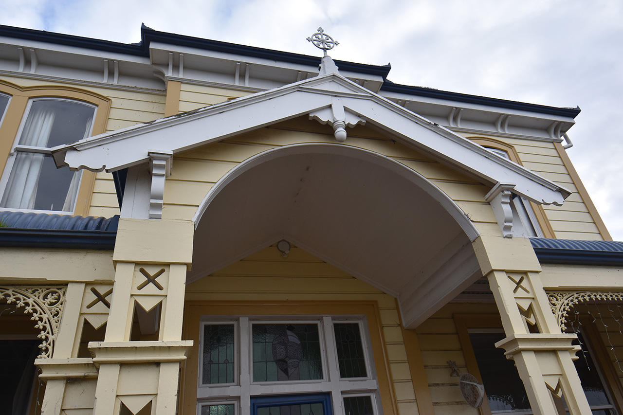
Current Description The former presbytery is located amidst the paddocks and vineyards of rural Seaview/Blind River, just south of the Awatere River from Lower Dashwood. On approach up the long driveway from Seaview Road, the house is clearly visible across the flat paddocks, against a backdrop of the Marlborough hills. Despite the impact of the building’s large size being somewhat diminished by the scale and grandeur of its setting, the former presbytery still dwarfs the single-storey villa next door. This view of the former presbytery is familiar to the members of Marlborough’s pony clubs, who regularly gather here for equestrian cross-country events hosted by the Redwoods on their property. The two-storeyed residence is roughly rectangular in plan. The corrugated-steel roof form expresses the two stages of the building’s development. A rectangular hipped roof tops the 1891 front half, with the 1911 addition delineated by two parallel hipped gables running longways to roof the rear half. Between the parallel gables is a flat section of roof wide enough to hold a skylight above the central first-floor hallway. Chimneys were not reinstated in the relocation. Pairs of thin decorative timber eaves brackets support the roof overhangs on all sides. The rusticated weatherboard cladding is punctuated by generous timber-framed fenestration on both levels. Ground-floor windows are rectangular double-hung sashes, and upper-level windows have characteristically Italianate flat-arch top surrounds. All windows have noticeably low sills from inside the rooms. The eastern façade of the house is dominated by a central single-gabled porch with arched entranceway, flanked by a bullnosed verandah extending around both sides of the house. This was previously the main, street-facing entrance, and it is accordingly ornamented to convey that status. The timber verandah posts provide the most ornate ‘Victorian’ feature of the exterior, being of an open design of thinner supports braced with triangles, diamonds, and cross-pierced infills. Lacy cast-iron fretwork brackets and friezes span between each verandah post. A low railing of diagonal cross-bracing completes the verandah area. A small stylised cross-shaped finial at the apex of the porch gable’s bargeboards provides the only obvious symbol of the building’s previous life as a presbytery. The porch protrudes from a central bay that extends up both storeys of the building. The upper storey has a pair of double-windows to each side of the bay, gracing the ‘best’ bedrooms at what was formerly the front of the house. The driveway leads to what was previously the rear of the house; on its new site the old ‘back door’ is now used as the house’s main entrance, at the west. A small lean-to sits to the southwest of a central window, and an awning extends from this to shelter the doors that are on either side of the window. The southwestern door provides independent access to what was previously the housekeeper’s flat. The northwestern door enters into the main house. A central utility room leads to a large kitchen, well-lit by large windows looking out to the north sun. A pair of French doors leading to a deck sheltered by a vine-covered pergola is one of the few alterations the owners have made to the building envelope since the presbytery was relocated. Modern kitchen fixtures have been installed to complement the original large fire-surround that presumably once housed a range cooker. A large dining room is accessed from the kitchen. A varnished timber flat arch with carved corner brackets marks where the room extends beyond the line of the northern façade of the house to meet the northern arm of the verandah, which is accessed through a panelled door. Three large windows provide ample light for this high-ceilinged room, decorated with vertical tongue and groove varnished timber panelling below a dado. An office with built-in cabinetry sits at the north-eastern corner of the ground floor. The dimensions of this room are mirrored by the room on the southern side of the main hallway. All four easternmost rooms contain their original timber fire surrounds. The central hallway is noticeably wide and grand, to match the high stud throughout the house. The former front door has coloured leadlighting in a stylised floral design on its upper half, and this is complemented by similar sidelights and transom lights. Varnished timber panelling decorates the lower third of the walls, including up the stairs, which dominate this space. A timber round arch completes this entrance hall. A small passageway leads south under the stairs, to a large lounge that was extended to meet the verandah in the early 1960s. Décor in here is noticeably plainer, and window joinery is different, in accordance with the later construction date of the extension, circa 1940s-1960s. A door on the western side of the passageway provides access to steps down to the cellar, installed by the owners when the building was relocated to the site. The ground floor rooms are completed by the former housekeeper’s suite, including bathroom, in the southwestern corner. These rooms feature plain doors with chrome handles, different from the panelled doors with ribbed black doorknobs throughout the rest of the house. The central staircase describes the two stages of the building’s construction, leading up to a small landing from which two shorter staircases then branch east to the upper storey of the 1891 half, and west to that of the 1911 half. The timber balusters of the 1911 stairs are turned to a different profile than those of the 1891 balustrades. A door on the landing leads to the servant’s staircase: narrow, unadorned and lit by a small skylight set high above. The upper-level hallway is impressively wide. Four large bedrooms are ranged along the southern side while the north accommodates five of varying sizes, plus a storage room. The family bathroom is located centrally at the western end, mirrored by the placement of a master ensuite at the eastern end. The 1911 skylight, set in the ceiling south of a beam dividing the two stages of the building, is a notable feature. Its’ simple but striking diamond design is similar to that of the double entrance doors to the Mercy Room chapel at the Maxwell Road Catholic complex in Blenheim, designed by the same architect (John Sydney Swan) two years earlier. The skylight also contains panes of green and clear cathedral glass in the same ‘Imperial (No.27)’ pattern of floral emblems of the United Kingdom (thistle, oak, rose, shamrock) featured in the Mercy Room doors and windows. The bathroom window also features this patterned glass.
Current Description The former presbytery is located amidst the paddocks and vineyards of rural Seaview/Blind River, just south of the Awatere River from Lower Dashwood. On approach up the long driveway from Seaview Road, the house is clearly visible across the flat paddocks, against a backdrop of the Marlborough hills. Despite the impact of the building’s large size being somewhat diminished by the scale and grandeur of its setting, the former presbytery still dwarfs the single-storey villa next door. This view of the former presbytery is familiar to the members of Marlborough’s pony clubs, who regularly gather here for equestrian cross-country events hosted by the Redwoods on their property. The two-storeyed residence is roughly rectangular in plan. The corrugated-steel roof form expresses the two stages of the building’s development. A rectangular hipped roof tops the 1891 front half, with the 1911 addition delineated by two parallel hipped gables running longways to roof the rear half. Between the parallel gables is a flat section of roof wide enough to hold a skylight above the central first-floor hallway. Chimneys were not reinstated in the relocation. Pairs of thin decorative timber eaves brackets support the roof overhangs on all sides. The rusticated weatherboard cladding is punctuated by generous timber-framed fenestration on both levels. Ground-floor windows are rectangular double-hung sashes, and upper-level windows have characteristically Italianate flat-arch top surrounds. All windows have noticeably low sills from inside the rooms. The eastern façade of the house is dominated by a central single-gabled porch with arched entranceway, flanked by a bullnosed verandah extending around both sides of the house. This was previously the main, street-facing entrance, and it is accordingly ornamented to convey that status. The timber verandah posts provide the most ornate ‘Victorian’ feature of the exterior, being of an open design of thinner supports braced with triangles, diamonds, and cross-pierced infills. Lacy cast-iron fretwork brackets and friezes span between each verandah post. A low railing of diagonal cross-bracing completes the verandah area. A small stylised cross-shaped finial at the apex of the porch gable’s bargeboards provides the only obvious symbol of the building’s previous life as a presbytery. The porch protrudes from a central bay that extends up both storeys of the building. The upper storey has a pair of double-windows to each side of the bay, gracing the ‘best’ bedrooms at what was formerly the front of the house. The driveway leads to what was previously the rear of the house; on its new site the old ‘back door’ is now used as the house’s main entrance, at the west. A small lean-to sits to the southwest of a central window, and an awning extends from this to shelter the doors that are on either side of the window. The southwestern door provides independent access to what was previously the housekeeper’s flat. The northwestern door enters into the main house. A central utility room leads to a large kitchen, well-lit by large windows looking out to the north sun. A pair of French doors leading to a deck sheltered by a vine-covered pergola is one of the few alterations the owners have made to the building envelope since the presbytery was relocated. Modern kitchen fixtures have been installed to complement the original large fire-surround that presumably once housed a range cooker. A large dining room is accessed from the kitchen. A varnished timber flat arch with carved corner brackets marks where the room extends beyond the line of the northern façade of the house to meet the northern arm of the verandah, which is accessed through a panelled door. Three large windows provide ample light for this high-ceilinged room, decorated with vertical tongue and groove varnished timber panelling below a dado. An office with built-in cabinetry sits at the north-eastern corner of the ground floor. The dimensions of this room are mirrored by the room on the southern side of the main hallway. All four easternmost rooms contain their original timber fire surrounds. The central hallway is noticeably wide and grand, to match the high stud throughout the house. The former front door has coloured leadlighting in a stylised floral design on its upper half, and this is complemented by similar sidelights and transom lights. Varnished timber panelling decorates the lower third of the walls, including up the stairs, which dominate this space. A timber round arch completes this entrance hall. A small passageway leads south under the stairs, to a large lounge that was extended to meet the verandah in the early 1960s. Décor in here is noticeably plainer, and window joinery is different, in accordance with the later construction date of the extension, circa 1940s-1960s. A door on the western side of the passageway provides access to steps down to the cellar, installed by the owners when the building was relocated to the site. The ground floor rooms are completed by the former housekeeper’s suite, including bathroom, in the southwestern corner. These rooms feature plain doors with chrome handles, different from the panelled doors with ribbed black doorknobs throughout the rest of the house. The central staircase describes the two stages of the building’s construction, leading up to a small landing from which two shorter staircases then branch east to the upper storey of the 1891 half, and west to that of the 1911 half. The timber balusters of the 1911 stairs are turned to a different profile than those of the 1891 balustrades. A door on the landing leads to the servant’s staircase: narrow, unadorned and lit by a small skylight set high above. The upper-level hallway is impressively wide. Four large bedrooms are ranged along the southern side while the north accommodates five of varying sizes, plus a storage room. The family bathroom is located centrally at the western end, mirrored by the placement of a master ensuite at the eastern end. The 1911 skylight, set in the ceiling south of a beam dividing the two stages of the building, is a notable feature. Its’ simple but striking diamond design is similar to that of the double entrance doors to the Mercy Room chapel at the Maxwell Road Catholic complex in Blenheim, designed by the same architect (John Sydney Swan) two years earlier. The skylight also contains panes of green and clear cathedral glass in the same ‘Imperial (No.27)’ pattern of floral emblems of the United Kingdom (thistle, oak, rose, shamrock) featured in the Mercy Room doors and windows. The bathroom window also features this patterned glass.
Historical and Associated Iwi / Hapū / Whānau
Completion Date
15th November 2022
Report Written By
Blyss Wagstaff
Information Sources
Cahill, 1964
P. Cahill, Centennial of St Mary's Parish, Blenheim, 1964
Furness, 1978
J. Furness, A Century of Worship 1878-1978, Blenheim, 1978
Marlborough Express
Marlborough Express
Vavasour, 2014
Belinda Vavasour (ed.), Communities of Worship: St Mary’s Parish, Blenheim, 1864-2014, St Mary’s Parish, Blenheim, 2014
Other Information
A fully referenced copy of the review report can be requested from the Central Regional Office of Heritage New Zealand Pouhere Taonga Disclaimer Please note that entry on the New Zealand Heritage List/Rārangi Kōrero identifies only the heritage values of the property concerned, and should not be construed as advice on the state of the property, or as a comment of its soundness or safety, including in regard to earthquake risk, safety in the event of fire, or insanitary conditions. Archaeological sites are protected by the Heritage New Zealand Pouhere Taonga Act 2014, regardless of whether they are entered on the New Zealand Heritage List/Rārangi Kōrero or not. Archaeological sites include ‘places associated with pre-1900 human activity, where there may be evidence relating to the history of New Zealand’. This List entry report should not be read as a statement on whether or not the archaeological provisions of the Act apply to the property (s) concerned. Please contact your local Heritage New Zealand office for archaeological advice.
Current Usages
Uses: Accommodation
Specific Usage: House
Former Usages
General Usage: Accommodation
Specific Usage: House
General Usage: Religion
Specific Usage: Vicarage/Manse/Presbytery/Rectory
Current Usages
Uses: Accommodation
Specific Usage: House
Former Usages
General Usage: Accommodation
Specific Usage: House
General Usage: Religion
Specific Usage: Vicarage/Manse/Presbytery/Rectory
Sign up to hear more
Get the latest heritage news, features and events delivered
straight to your inbox.
