Early Māori History
Te Kaokaoroa-o-Pātetere, which lies to the west of the southern Kaimai and Mamaku Ranges, has been associated with multiple iwi. Ngāti Kahupungapunga occupied the region prior to the arrival of Tainui waka. Raukawa, who had been based around the Waikato Basin area, eventually expanded their rohe to encompass Te Kaokaoroa-o-Pātetere after a conflict with Ngāti Kahupungapunga and were well established in Te Kaokaoroa-o-Pātetere and further south by the mid-nineteenth century. The site of Drovers’ Trough and Accommodation Field (Former) lies within the rohe of Tūkorehe, a hapū of Raukawa, whose eponymous ancestor was ‘an important tupuna for the Kaokaoroa-o-Patetere district’. The region was rich with food and water resources including many puna and significant awa.
Raukawa were aligned with the Kiingitanga movement and opposed British colonial forces in multiple battles including Ō-Rākau, Gate Pā, and Te Ranga in 1864. Substantial portions of Raukawa land was subject to Raupatu (land confiscation) by the Crown although parts of Te Kaokaoroa-o-Pātetere appear to have largely remained under hapū control under individualised title. Strategically located near the intersection of routes by land and water connecting Waikato, Tauranga and Rotorua and in close proximity of the military township of Cambridge was the settlement of Te Tāpapa. In January 1870 Te Kooti (Rongowhakaata) joined Hakaraia Mihara, a Waitaha prophet whose ancestral lands around Rotorua had been subject to Raupatu, at Tāpapa while being pursued by Pākehā and Māori Crown forces. The settlement was attacked and burned by these forces on January 24th 1870 although Te Kooti had left in the preceding days. In the aftermath of the conflict many marae were relocated.
Further Alienation of Raukawa lands
The Crown and wealthy Pākehā land speculators were expressing interest in acquiring additional land within Raukawa’s Waikato rohe by the early 1870s. The Crown, which was working to detach Raukawa from the Kiingitanga, sought to open up the area to development through the construction of roads. One of the proposed roads would connect Cambridge and Rotorua via Tapapa following an older Māori ara along the ridge above Waiohotu Stream and through the Mamaku Ranges. With support from Te Arawa and Pākehā settlers at Rotorua a survey of the road was begun in 1872 however, the Kiingitanga and groups within Raukawa opposed the work which was quickly put on hold while further negotiations were conducted between the iwi and the Crown. An agreement was reached in the early 1880s, although not all within Raukawa were in support, and construction was undertaken by the Armed Constabulary from 1881. Water was difficult to access during construction as the waterways were in deep gullies and had to be pumped up and carried to the camps. The new route greatly shortened the distance to Rotorua from Auckland and supported thermal tourism in Rotorua and Okoroire as well as other essential industries.
During the 1870s Crown agents and Pākehā land speculators began meeting with individuals from Raukawa in efforts to purchase large blocks of land although Raukawa banned surveying within their rohe. In 1873, following the killing of Timothy Sullivan – a Pākehā farm worker who trespassed near the Autaki line, the Government re-instituted Crown pre-emption on all land purchases in Patetere, meaning that only the Crown could purchase the land directly from Raukawa. However land speculators continued to secretly meet with Raukawa and give them money in the hopes of being able to obligate a sale at a later date, while publicly lobbying for a law reversal in their favour. Following the defeat of George Grey’s administration in 1879 and with the onset of the Long Depression the incoming government decided that it was not economically feasible to purchase the Patetere and Whaiti Kuranui blocks and the pre-emption block was removed. The land speculators, generally wealthy Auckland businessmen who would not be affected by the Depression for several more years, formed syndicates to purchase extensive amounts of land from Raukawa. Large portions of the Whaiti Kuranui No. 2 block, near Te Tāpapa, including Section 2 which encompassed part of the Cambridge-Rotorua road and Waiohotu Stream, was purchased by Edwin Barnes Walker of Mona Vale, Cambridge, and Joseph Howard of Auckland in 1881.20 This block was then consolidated under the ownership of the Patetere Land Company, later the Thames Valley Land Company (TVLC), which Walker and Barnes were both directors of.
Many of the large estates purchased by these syndicates failed financially in the 1890s as they were not able to be developed profitably during the Long Depression. After raising funds for the company in London, including additional investment from the Bank of New Zealand (BNZ) who had advanced funds for the initial land purchases, the Thames Valley Land Company was in serious financial difficulty by the mid-1890s. In an effort to save the BNZ from collapse the Government stepped in to bail out the bank and took the TVLC assets into Crown control. Much of the land was subsequently sold as farms, including one adjoining the Cambridge to Rotorua road to John Kittow, and part of Whaiti Kuranui 2C, where the Water Trough and Accommodation Field would later be created, was set aside as a Scenic Reserve.
Droving in New Zealand
During a period of tightening connections between New Zealand and Britain identified by historian James Belich as recolonisation, the number of small farms around New Zealand increased 30-fold between 1890 and 1911, largely on the back of protein farming of high volumes of sheep, cattle and dairy for refrigerated export to Britain. By 1901 protein exports comprised two thirds of all New Zealand exports to Britain. The development of a pastoral economy of commercially viable, intensive small scale farms established stratified farming operations tailored to the topography of different parts of the country, necessitating increased stock movement to take advantage of differing environmental conditions. Since the earliest sheep farms in the South Island began in the nineteenth century, droving, the movement of stock ‘from farmgate to saleyards, abattoirs, railheads, freezing works or another farm’ on hoof by road, had been an integral method of stock transport around the country. With increasing intensification and specialisation of farming operations around the turn of the century, droving of sheep and cattle, either to a railhead where available or the entire distance farm to farm, was an essential facilitating factor. It was a way of life for the drovers who would regularly travel the same routes for weeks or months with their mobs. Many Māori found employment as drovers including whānau from Tapapa. The practice required reliable road routes which were advocated for by Māori and Pākehā who saw the opportunities for rural communities. Many droving routes became well established around the country. Well built and maintained stock routes meant stock arrived at their destination in good condition saving farmers time and money. By 1894 the Tapapa to Rotorua Road was already regularly being used for droving and formed part of a route between Heretaunga and Horotiu.
The Gisborne and East Coast region was the largest sheep-bearing area in the Auckland province however, there were few local freezing works prior to 1911. In 1908 approximately 80,000 ewes were transported north from Gisborne, of which 16-20,000 were taken to small farms in the Waikato which needed to be regularly restocked as the region became a farming centre. From at least 1905 public pressure for improved stock routes connecting Gisborne and the East Coast to the Waikato and further north were supported by the Farmers’ Union as well as Māori leaders such as Rua Kenana who hoped accessible stock routes would make his Maungpōhatu community economically viable. Improvements undertaken included new roads to substantially shorten the journey by up to 14 days, as well as the provision of stock yards and water supplies that drovers could use for their stock between destinations. In 2023, Tūkorehe kaumatua Steven O’Brien recalled that his Tupuna tāne (grand-uncle) Putu O’Brien, who worked as a cattle drover on the Gisborne – Horotiu route during the 1960s, would travel about fifteen miles a day between regular stops during his two – three month journeys, including stops at ‘Okoroire near the current camping ground’ and a shepherd’s hut on the road to Rotorua.
Creation of Drovers’ Trough and Accommodation Field
Farmers near Tapapa called for droving facilities in their area in the early twentieth century including Johnathon Kittow, who offered the water supply from his own farm, and J.W. Wrigley, an architect from Rotorua who had assisted in the design and construction of the Rotorua bathhouse in 1903-6. The need for facilities on the Tapapa to Rotorua road was officially recognised in July 1909 when an 11 acre portion in the block was gazetted by the Crown for a ‘Stockyard and water reserve for stock’. The reserved land included a puna (spring) that was historically utilised by Tūkorehe for drinking, preparation of kai, and tikanga purposes. The land was subsequently vested in the Matamata County Council in September of the same year although it took until 1911 for the paddock and trough to be properly established due to funding issues. The government refused to fully fund the £150 cost, instead suggesting they would subsidise any money contributed by the county council pound for pound up to £75. As there were very few ratepayers in the area, which was largely composed of Māori land and scenic reserve, the local settlers, led by Wrigley, struggled to raise their half of the funds. In March 1911 Wrigley proposed a less expensive scheme to only build the trough and leave the stock paddock unfenced but the council rejected the plan, deciding that the full scheme needed to be completed or nothing would be done at all. By September 1911 Wrigley had raised nearly £70 by subscription and the council agreed to apply for the government subsidy and cover any remaining costs. By the time funding was secured the need for the water supply was becoming urgent as a new saleyard had been established at Ngongotaha and a large number of cattle had accordingly passed through the area. After calling for tenders, the fencing and trough construction was completed by mid-November. Although J.W. Wrigley evidently supplied a design for the trough and pumping system, it does not appear to have been adopted for this project.
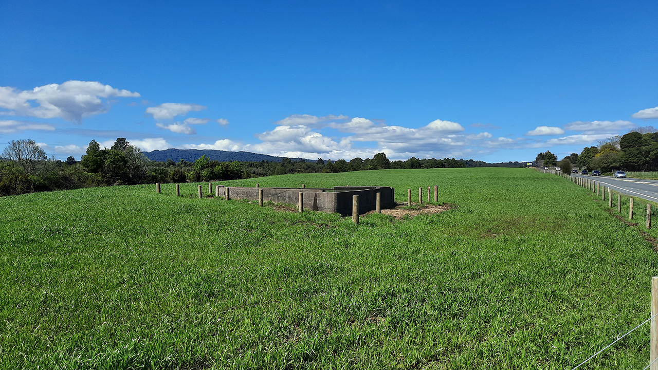
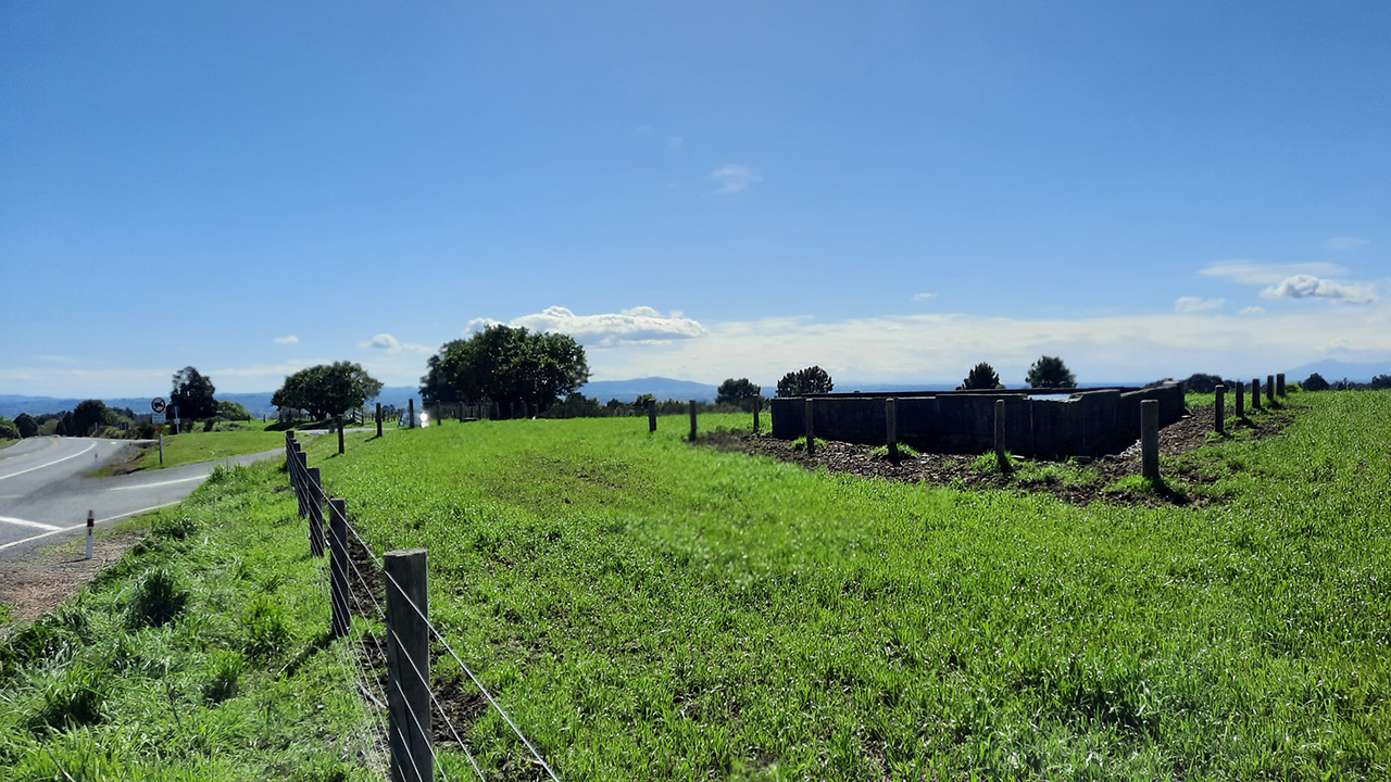
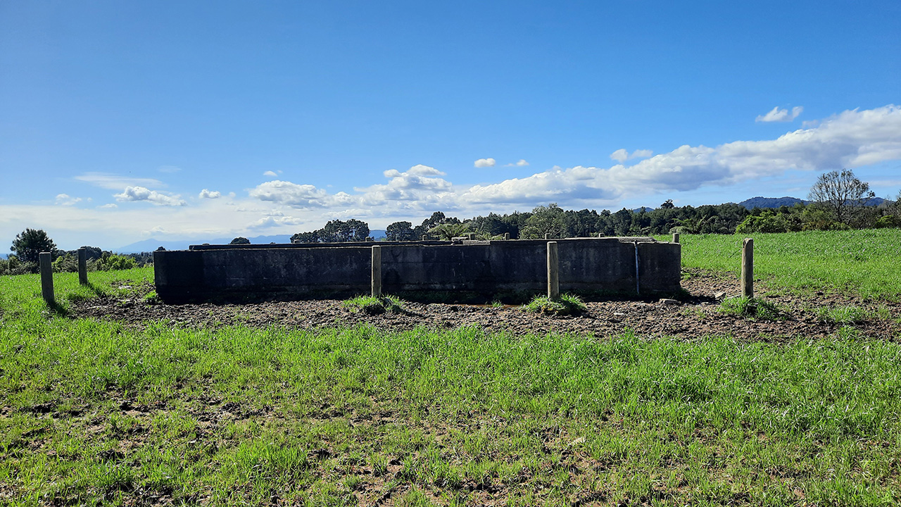
The site was generally L-shaped and ran parallel to a steep gully along the north side. The east end extended down into the gully to encompass the spring. The field was cleared of bush and trees with a fenced rectangular perimeter to secure stock between the road and the gully. The trough was positioned slightly to the east of centre along the southern edge near the road. The concrete trough was a triangular structure with one side parallel to the road. The fence along the road edge was angled diagonally to meet each corner of the trough with a gate on either side making the trough accessible from two sides inside the field and the road without needed to go through the gate. Constructed of concrete bricks, the trough measured approximately 9m along each side and was connected to the spring by pipes. The water supply was then pumped from the spring to the trough with a Number 15 pump.
Use of Drovers’ Trough and Accommodation Field
Within a short time of completion, the Trough and Accommodation Field were in frequent use for cattle and sheep mobs, forming part of a network of resting stops along the droving route. As well as being used by drovers, the trough was quickly put to other purposes including as a stopping location for passing motorcars by 1914. Kittow – who still farmed his adjoining property – regularly hosted drovers overnight in his farmhouse which reflected the community links that were established through droving. The Matamata council continued to manage the place for many years and by the late 1930s had appointed a local farmer to maintain the site with compensation in the form of grazing rights in the Accommodation Field. Also during the 1930s the Tapapa to Mamaku section of the road was reconstructed and resealed improving access to the site.
Although well used, the trough had recurring problems with its water supply during its first fifteen years. During and immediately after dry periods the water flow through the pump at the spring was insufficient for the pump size that had been installed resulting in periods when the trough would run dry, a particular problem for drovers with larger herds. Repairs were regularly made to system and in 1915 the pump was replaced by a Blake Hydram pump specially imported from England. This did not entirely resolve the issues however and so a decade later the water supply was reorganised to draw directly from the Waiohotu Stream at the bottom of the gully on the north side and further overhauled again two years later. The fences around the Accommodation paddock were renewed in 1938 and in April 1939 local famers suggested replacing the triangular trough with larger rectangular troughs which would make water provision for large herds more practical. Possibly due to the outbreak of the Second World War (1939-1945) later that same year, these plans were never developed further.
Decline of Droving
Droving as the main form of road transport of animals had first begun to decline in the late 1920s however a nationwide shift towards use of stock trucks accelerated from the 1950s as farmers increasingly built the farm infrastructure necessary for loading and unloading trucks. Droving continued longer in the North Island than the South Island due to the higher proportion of cattle stock. In addition to changing farming habits, public attitudes towards droving became more negative during the later twentieth century as more people had access to cars and encountered delays due to droving mobs on roads more frequently leading to greater restrictions via council bylaws. By the last decades of the century droving had almost completely disappeared from New Zealand roads.
With the increase of stock trucks on the road, the discarding of stock effluent directly onto the road surface caused slippery patches to develop which were hazards for other motorists as well as causing adverse effects on the natural environment. In the Waikato in 1992 a motorcyclist was killed after losing control of their bike driving through one of these patches and in response the Waikato Region began creating stock effluent disposal facilities to stop effluent being discharged directly onto the road. The Tapapa Drovers’ Trough and Accommodation Field had largely been maintained as originally built with direct access to the trough from the roadside, despite the decrease in use by drovers, until 1995 when the most substantial change to the site was undertaken. A rectangular section in the centre of the Accommodation Field was taken for a Stock Effluent Disposal with drains, anaerobic/aerobic oxidation pond system, and soakage trenches constructed as part of a pilot program. The trough remained in situ to the immediate east of the disposal site boundary. The road alignment was also rebuilt to form a layby bay for trucks to stop in while using the facility. Access to the trough from the road was entirely disrupted with these changes. The new fence line ran along the roadside, no longer connected to the trough, and the road level was cut lower than the trough.
The trough has been maintained since 1995 with wooden bollards to protect the structure installed. The Accommodation Field has been in use as part of farm.