DonateSupporterVisit Heritage
  • Tūrangawaewae
    Places
  • Tira Māori
    Māori Heritage
  • Poutairangahia
    Archaeology
  • Rauemi
    Resources
  • Mō Tātou
    About Us
  • New Zealand Heritage List
  • Nominate and submit
  • Explore the List
  • National Historic Landmarks
  • Plaques
  • Rainbow List Project
  • Lost heritage
  • Visit Heritage
  • Our properties
  • Turnbull House Project
  • Collections
  • Shop
  • Tohu Whenua
  • Tira Māori
  • Conserving Māori heritage
  • Marae built heritage
  • Māori heritage on the List
  • Hinemihi—Te Hokinga Mai
  • What is archaeology?
  • Is there a site on my property?
  • What are my legal requirements?
  • Affecting an archaeological site
  • Declaring an archaeological site
  • Archaeology FAQs
  • Archaeology Digital Library
  • Archaeology guidelines and templates
  • Resources
  • Funding
  • Publications
  • Sustainable management guides
  • Disaster recovery
  • Podcasts & digital resources
  • Education Hub
  • Conservation plans
  • About
  • Board
  • Māori Heritage Council
  • Senior Staff
  • Offices
  • Contact us
  • Careers
  • Covenants
  • Fast-track
  • Corporate documents
  • Currently consulting on
  • Our submissions
  • News
  • Covid-19 response
Quick links
Rārangi Kōrero | The List
Explore the List
National Historic Landmarks
Ngā Manawhenua o Aotearoa me ōna Kōrero Tūturu
Quick links
Tapuwae
A Vision for Places of Māori Heritage
Funding for Māori Heritage
Resources
Quick links
Archaeological Authority Portal
Applying for an archaeological authority
Archaeology FAQs
Browse the most frequently asked questions about archaeological authorities and the archaeological process.
Quick links
Quick links
Contact us
Offices
  • Places
  • Nominate and submit
  • National Historic Landmarks
  • Places
  • Nominate and submit
  • National Historic Landmarks
  • Tira Māori
  • Conserving Māori heritage
  • Marae built heritage
  • Tira Māori
  • Conserving Māori heritage
  • Marae built heritage
  • Archaeological authorities
  • Archaeology Digital Library
  • Archaeological authorities
  • Archaeology Digital Library
  • All resources
  • Publications
  • Funding
  • All resources
  • Publications
  • Funding
  • FAQs
  • FAQs
Follow us on:
Places
  • Places
  • Nominate and submit
  • National Historic Landmarks
Tira Māori
  • Tira Māori
  • Conserving Māori heritage
  • Marae built heritage
Archaeology
  • Archaeological authorities
  • Archaeology Digital Library
Resources
  • All resources
  • Publications
  • Funding
FAQs
  • FAQs
Follow us on
HomePrivacyTerms and conditionsAbout this site
© Heritage New Zealand Pouhere Taonga 2026.
 
Mandeville Bridge

Black Street; Davie Street, Kaiapoi River, KAIAPOI

Private

Historic Place Category 2

List No. 1812

Quick links:
List GalleryLocationDetails
Constructed in 1873-4, the ‘swing’ footbridge known as Mandeville Bridge has historical significance as the longest serving of all Waimakariri Bridges. Spanning the Kaiapoi River between Raven Quay and Charles Street, the bridge provides a practical safe passage to allow pedestrians to cross the river on the line of Black Street to the west and Davie Street at Trousselot Park to the east.
Kaiapoi and the surrounding area have a long and significant history of Māori settlement and occupation. From the mid nineteenth century, Pākehā missionaries and immigrants settled in Kaiapoi, many arriving as part of the Canterbury Association settlement programme. The Kaiapoi River was one of the main reasons for the town to be sited where it is. First named Gladstone by the planners, by 1854 the town had a wool store, general store and hotel. It became a flourishing port and ships could travel upstream to the woollen mills to load goods. In 1873, about 100 Kaiapoi residents petitioned the Canterbury Provincial Council for a footbridge over the Kaiapoi River. The main bridge in Kaiapoi, further down river, had been considered unreliable and unsafe especially in times of flood. The Mandeville footbridge was constructed in 1874 to allow school children to walk to the new Kaiapoi School. Construction began in late 1873 and in February 1874 the footbridge crossing the ‘north stream of the Waimakariri’, connecting Davie and Black Streets, was completed by contractor, William Stocks of Christchurch. The cost was £590, which included the earthwork formation of the approaches.
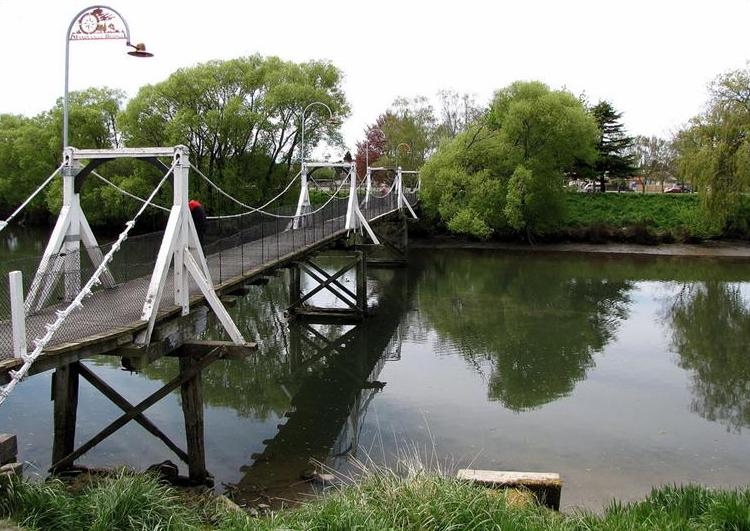
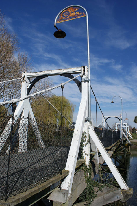
Constructed of timber and wire, the length of the bridge is approximately 66 metres. The suspension posts are 2.5 metres high. The posts carry wire ropes on iron pulleys and, from these, iron droppers carry the weight of the deck and its load. Piles bear suspension poles approximately 2.5 metres in height which connect above with timbers to form an archway. The bridge incorporates four curved lamp stands, the end one incorporating laser cut steel decoration and the words Mandeville Bridge.

The bridge is thought to have been named after Viscount Mandeville, Canterbury Association member, although initially it was simply referred to as the footbridge or the ‘swing’ footbridge. Originally the bridge had a total length of 360 feet (110 metres), but this was shortened by half when swampy ground, now part of Trousselot Park, was reclaimed. The bridge was repaired in 2011 following damage caused in the Canterbury earthquake of 4 September 2010.
Mandeville Bridge, Kaiapoi | R Burgess | 04/05/2024 | Heritage New Zealand Pouhere Taonga

List Entry Information

Overview

Status
Listed

List Entry Status
Historic Place Category 2

Access
Private/No Public Access

List Number
1812

Date Entered
23rd June 1983

Date of Effect
23rd June 1983

City/District Council
Waimakariri District

Region
Canterbury Region

Extent of List Entry

Extent includes part of the land described as Lot 13 DP 1280 (RT CB524/86) and part of the land described as Legal River, Canterbury Land District and the structure known as Mandeville Bridge thereon. Refer to the extent map tabled at the Rārangi Kōrero meeting on 8 June 2017.

Legal description

Lot 13 DP 1280 (RT CB524/86) and Legal River, Canterbury Land District

Location Description

Spanning the Kaiapoi River between Black and Davie Streets, KAIAPOI

Detailed List Entry

Construction Professional

Name

William Stocks

Type

Builder

Biography

No biography is currently available for this construction professional

Construction Details

Start Year

1873

Finish Year

1874

Type

Original Construction

Type

Modification

Description

Mandeville Bridge shortened

Period

C. 1920s

Reference

Completion Date

5th May 2017

Report Written By

Robyn Burgess

Report Written By

This place was identified as significant under previous legislation with different information requirements. It remains significant under the current legislation. There is opportunity under our legislation and policies to add to this information. Further information about this place may be available from the Southern Regional Office of Heritage New Zealand Pouhere Taonga. Please note that entry on the New Zealand Heritage List/Rarangi Korero identifies only the heritage values of the property concerned, and should not be construed as advice on the state of the property, or as a comment of its soundness or safety, including in regard to earthquake risk, safety in the event of fire, or insanitary conditions. A fully referenced upgrade report is available on request from the Southern Region Office of Heritage New Zealand.

Further Information

Current Usages

Uses: Transport

Specific Usage: Bridge/ Viaduct

Former Usages

Themes

Web Links

Overview

Status

Listed

List Entry Status

Historic Place Category 2

Access

Private/No Public Access

List Number

1812

Date Entered

23rd June 1983

Date of Effect

23rd June 1983

City/District Council

Waimakariri District

Region

Canterbury Region

Extent of List Entry

Extent includes part of the land described as Lot 13 DP 1280 (RT CB524/86) and part of the land described as Legal River, Canterbury Land District and the structure known as Mandeville Bridge thereon. Refer to the extent map tabled at the Rārangi Kōrero meeting on 8 June 2017.

Legal description

Lot 13 DP 1280 (RT CB524/86) and Legal River, Canterbury Land District

Location Description

Spanning the Kaiapoi River between Black and Davie Streets, KAIAPOI

Construction Information

Construction Professional

Name

William Stocks

Type

Builder

Biography

No biography is currently available for this construction professional

Construction Details

Start Year

1873

Finish Year

1874

Type

Original Construction

Type

Modification

Description

Mandeville Bridge shortened

Period

C. 1920s

Reference

Historical and Associated Iwi / Hapū / Whānau

Completion Date

5th May 2017

Report Written By

Robyn Burgess

Other Information

This place was identified as significant under previous legislation with different information requirements. It remains significant under the current legislation. There is opportunity under our legislation and policies to add to this information. Further information about this place may be available from the Southern Regional Office of Heritage New Zealand Pouhere Taonga. Please note that entry on the New Zealand Heritage List/Rarangi Korero identifies only the heritage values of the property concerned, and should not be construed as advice on the state of the property, or as a comment of its soundness or safety, including in regard to earthquake risk, safety in the event of fire, or insanitary conditions. A fully referenced upgrade report is available on request from the Southern Region Office of Heritage New Zealand.

Further Information

Current Usages

Uses: Transport

Specific Usage: Bridge/ Viaduct

Current Usages

Uses: Transport

Specific Usage: Bridge/ Viaduct

Location

Loading
Sign up to hear more

Get the latest heritage news, features and events delivered
straight to your inbox.

Subscribe