

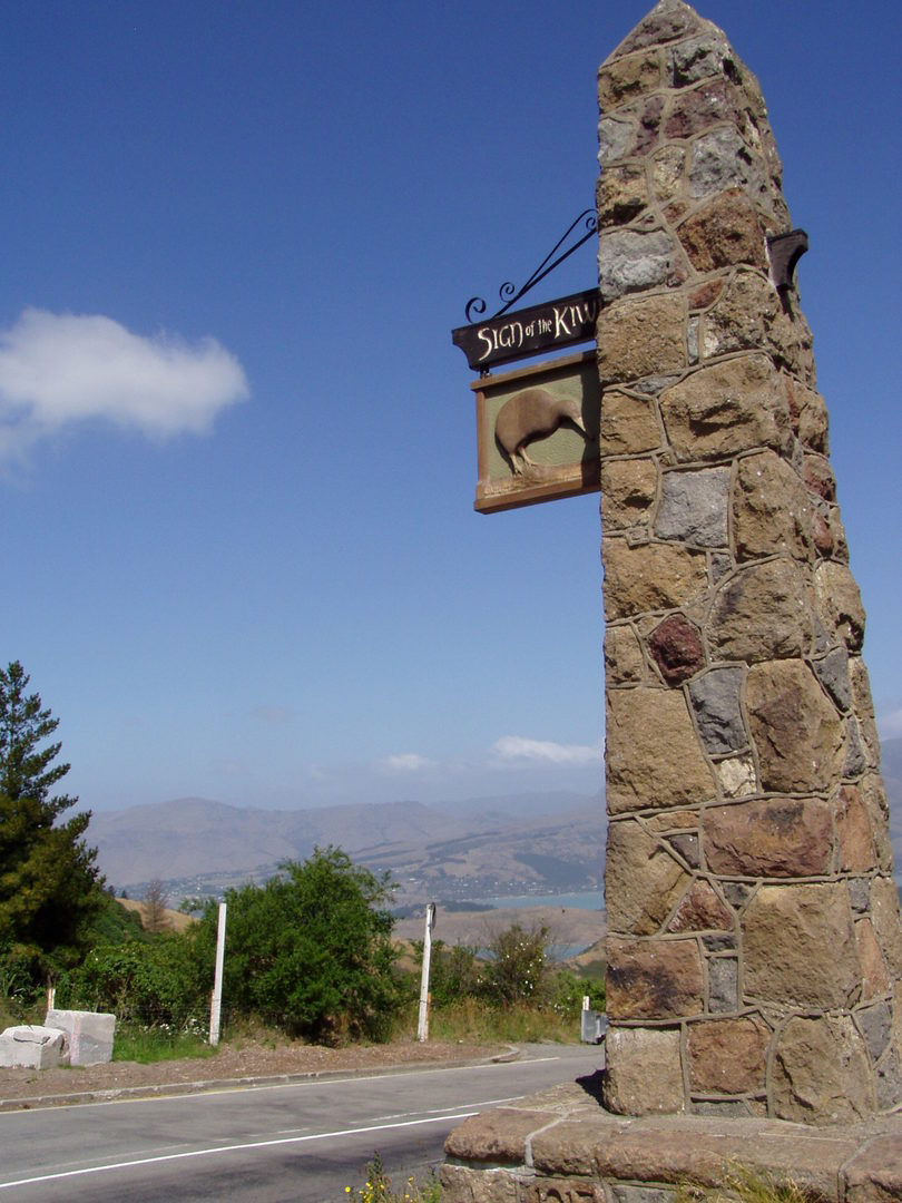
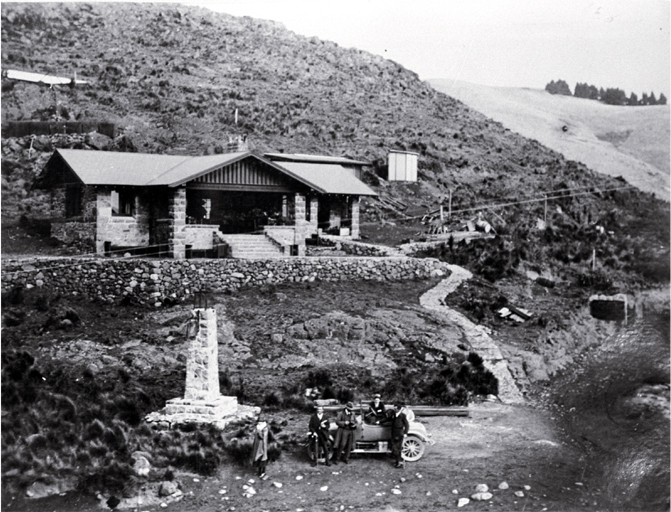
The first of Ell's resthouses to be constructed was the Sign of the Bellbird (1914) at Kennedy's Bush, followed by a smaller shelter, the Sign of the Packhorse (1916), at the top of the Kaituna Saddle. Ell struggled with obtaining enough funding for his scheme and the boards he established to help with the Summit Road often publicly refused to pay debts Ell had incurred. Part of Ell's plan for the Sign of the Kiwi, his third resthouse, was that it would also act as a tollgate at the head of Dyers Pass, with the tolls going towards the construction of the remainder of the road, thus solving his financial difficulties. The Kiwi also provided tearooms and overnight accommodation. Ell's wife, Ada, took over the running of the tearooms in 1920 and ran them at a profit until a nervous breakdown forced her to leave in 1926. The tollgate lasted until 1932, when the Heathcote County Council settled a ten year dispute over the collection of tolls on this road by insisting Ell shut it down. However, Halswell County Council suggested Ell move the tollgate into their neighbouring county, which he did. The tollgate was re-established at Marleys Hill, where it stayed until Ell's death in 1934. Included in this registration are the stone section of the original tollgate and the stone pillar which used to support a gas lamp.
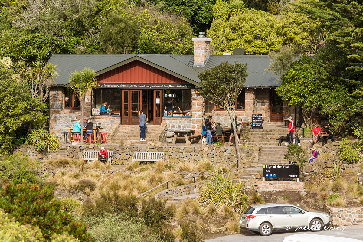
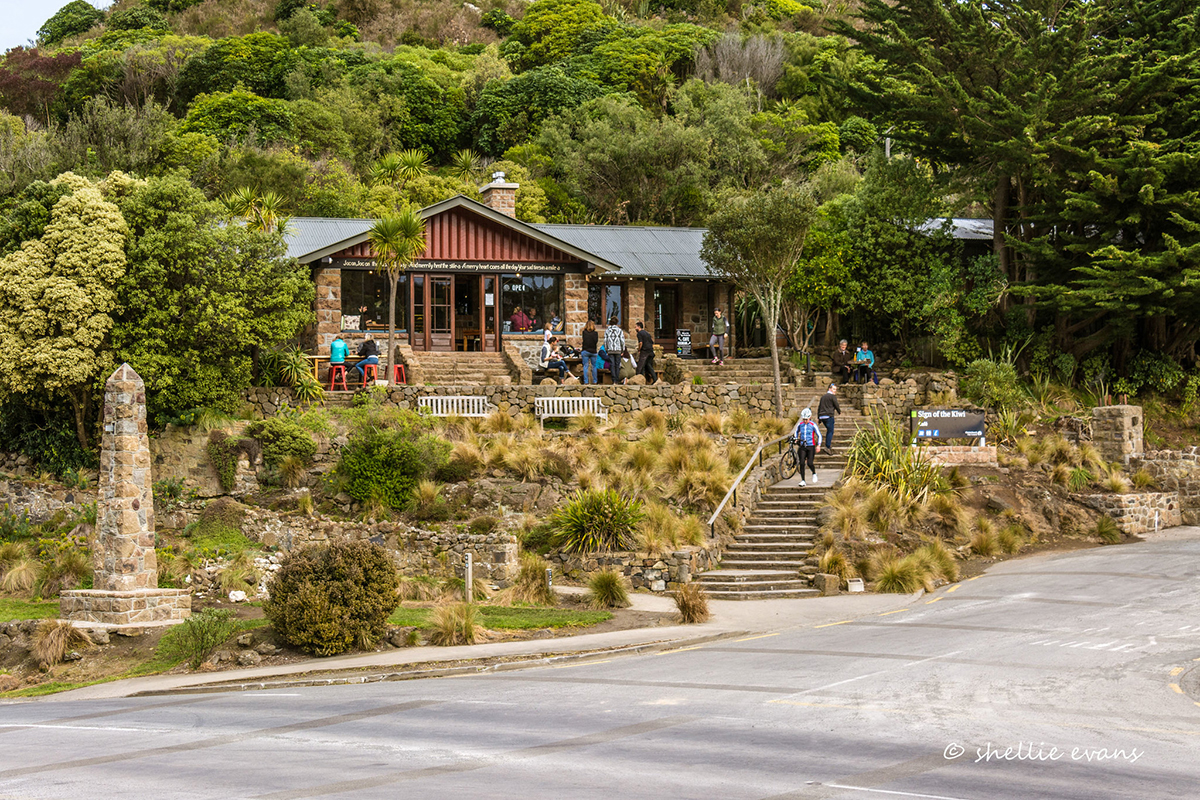
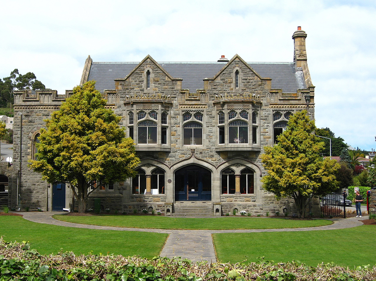
The Sign of the Kiwi was built with the donated assistance of many firms and individuals. It was designed by Samuel Hurst Seager (1855-1933), a Christchurch architect who also achieved renown as a town planner and an internationally respected authority on the lighting of art galleries. He had earlier designed the Sign of the Bellbird for Ell. Seager had a particular interest in vernacular domestic architecture and his design for the Sign of the Kiwi illustrates this concern. The Kiwi is an example of Seager's interpretation of the bungalow style, which he had earlier explored in other small houses around the Port Hills, such as 2 Whisby Road. It is a long low building with a wide gabled verandah over the main entrance. The interior is not lined, making the stone walls and exposed timber beams a feature of the building. As with the two earlier resthouses the Kiwi was intended to blend with the surrounding environment. Both the use of local volcanic stone and the careful siting of the building, ensured that the Kiwi did not disrupt the panorama of the hills.
During World War II the Sign of the Kiwi was abandoned and neglected. It was closed by the Department of Lands and Survey in the 1940s. Responsibility for the building was handed over to the Christchurch City Council after 1948. The council used the building as a custodian's house and modified it, retaining public access to the porch only. In 1989 the council began to restore the Sign of the Kiwi to its original state and it is again open for refreshments and as an information centre.
The Sign of the Kiwi is historically important as part of Ell's Summit Road scheme, which preserved for the local community access to an impressive area of land, still used extensively for recreation. Ell's scheme is important within the history of conservation in New Zealand as an early twentieth-century example of the conservation of the indigenous bush. The Sign of the Kiwi itself is significant as an example of Seager's interest in establishing a vernacular architecture in New Zealand, appropriate to the surrounding landscape. It is the only building on this stretch of road over Dyers Pass, and is a popular place to visit for tourists and residents alike.
List Entry Information
Status
Listed
List Entry Status
Historic Place Category 1
Access
Private/No Public Access
List Number
1930
Date Entered
21st September 1989
Date of Effect
21st September 1989
City/District Council
Christchurch City
Region
Canterbury Region
Legal description
Gaz 12-3352,48-307,9-13,13-14,Pt Res 3900 Blk II Halswell SD
Construction Professional
Name
Seager, Samuel Hurst
Type
Architect
Biography
Seager (1855-1933) studied at Canterbury College between 1880-82. He trained in Christchurch in the offices of Benjamin Woolfield Mountfort (1825-1898) and Alfred William Simpson before completing his qualifications in London in 1884. In 1885, shortly after his return to Christchurch, he won a competition for the design of the new Municipal Chambers, and this launched his career. Seager achieved renown for his domestic architecture. He was one of the earliest New Zealand architects to move away from historical styles and seek design with a New Zealand character. The Sign of the Kiwi, Christchurch (1917) illustrates this aspect of his work. He is also known for his larger Arts and Crafts style houses such as Daresbury, Christchurch (1899). Between 1893 and 1903 Seager taught architecture and design at the Canterbury University College School of Art. He was a pioneer in town planning, having a particular interest in the "garden city" concept. Some of these ideas were expressed in a group of houses designed as a unified and landscaped precinct on Sumner Spur (1902-14). He became an authority on the lighting of art galleries. After World War I he was appointed by the Imperial War Graves Commission to design war memorials in Gallipoli, Belgium and France. In New Zealand he designed the Massey Memorial, Point Halswell, Wellington (1925).
Construction Details
Start Year
1916
Finish Year
1917
finishYearCirca
Type
Original Construction
Type
Modification
Description
Various modifications including replacement of slate roof with corrugated iron, enclosure of front porch, and various internal partitions
Period
1950s
Notable Features
Stone Pillar: A tapering pillar built from local stone at the intersection of Dyers Pass Road and Summit Road, it is inscribed with the date 1917 and was initially surmounted by a gas lamp. The gas lamp was removed in 1925. It has a metal bracket which once supported a sign with a kiwi in imitation of old English inn signs. Tollgate: Only the stone section of the gateway remains. Its date of construction is uncertain. Photographs taken at the opening do not include the area where the tollgate stands and later photos are undated. A gas lamp, which appears to be the one originally on top of the stone pillar, was installed in 1925. It was mounted on a totara standard, fixed to a stone base adjacent to the gateway. Both the stone pillar and the stone section of the tollgate are included in the registration of the Sign of the Kiwi.
Historical and Associated Iwi / Hapū / Whānau
Completion Date
10th December 2001
Report Written By
Melanie Lovell-Smith
Information Sources
Ogilvie, 1991
Gordon Ogilvie, The Port Hills of Christchurch, Auckland, 1991
Other Information
This place was identified as significant under previous legislation with different information requirements. It remains significant under the current legislation. There is opportunity under our legislation and policies to add to this information. Further information about this place may be available from the Southern Regional Office of Heritage New Zealand Pouhere Taonga. Please note that entry on the New Zealand Heritage List/Rarangi Korero identifies only the heritage values of the property concerned, and should not be construed as advice on the state of the property, or as a comment of its soundness or safety, including in regard to earthquake risk, safety in the event of fire, or insanitary conditions.
Current Usages
Uses: Civic Facilities
Specific Usage: Information/Visitors Centre
Uses: Trade
Specific Usage: Restaurant/cafe/tearoom
Former Usages
General Usage: Trade
Specific Usage: Restaurant/cafe/tearoom
Current Usages
Uses: Civic Facilities
Specific Usage: Information/Visitors Centre
Uses: Trade
Specific Usage: Restaurant/cafe/tearoom
Former Usages
General Usage: Trade
Specific Usage: Restaurant/cafe/tearoom
Sign up to hear more
Get the latest heritage news, features and events delivered
straight to your inbox.
