

The fledgling settlement around the beach landing service in the shelter of Cape Wanbrow grew up in the late 1850s, where H.C. Hertslet built an accommodation house. The town survey was submitted to the Waste Lands Board in February 1859, setting the pattern for the future Oamaru. The grid pattern made only ‘occasional concessions’ to the lie of the land. The first survey was confined to the south of Oamaru Creek, and as the town developed, the creek became a formidable barrier. People crossed the street on planks and drays forded the creek near Steward Street.
Oamaru Creek was a barrier to the Provincial Government’s roading plans for a northern route. On 4 December 1860, the Provincial Government accepted the £1252 tender from John Roy. At the end of 1860, contractors began building the substantial bridge on the line of Thames Street. The contract specified Greystone from the hill near the Casa Nova property, but the contractors could not find large enough blocks, so requested permission to use limestone from near Awamoa. The stone bridge had a span of 24 feet [7.3 metres] and was 18 feet [5.5 metres] wide. In 1869, footpaths with wrought iron railings were added to the side of the bridge. Early photographs show the single arch bridge with rough faced stone, with a narrow pedestrian bridge on its upstream side.
The increasing traffic and the development of the business centre to the north of Oamaru Creek led to calls to widen the bridge. The North Otago Times lobbied the Provincial Government and the Municipal Council, describing the bridge’s ‘absurd narrowness, little better than a dangerous obstruction to the traffic along our main thoroughfare.’ By August 1875, the Provincial Government had voted £500 towards widening the bridge, and there were hopes that the council would contribute towards the cost. After some debate, the council decided that the bridge should be widened to the ‘full width of the street and pathway on each side.’
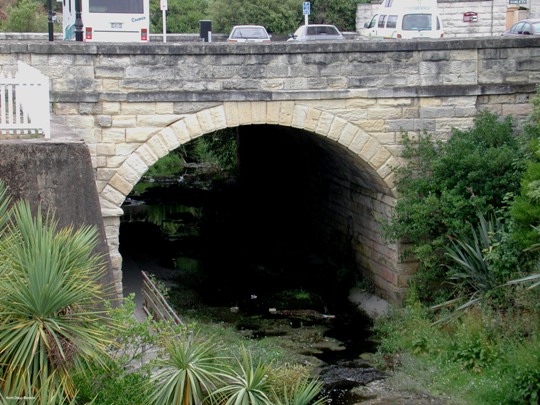
In February 1876 the town clerk called for tenders for the ‘Masonry and other works connected with the widening [of the] Thames Street Bridge’. The Council accepted the £1061 tender of Barclay and Kay. The tender was for the use of the Corporation Quarry stone, but later discussion permitted the contractors to use the ‘best Cave Valley stone’ with the approval of the surveyor and the Public Works Committee and with an appropriate reduction in price. The widening completed, the townspeople were proud of the substantial bridge – a full 2 chains wide – recognised at the time as the widest bridge in New Zealand, although among the shortest. Later reports identified it as the widest bridge in the Southern Hemisphere until the Sydney Harbour Bridge opened. The widened bridge was 40.24 metres wide and with a span of 7.32 metres. It is built of limestone, with a textured finish. The deck supports the road, flanked by footpaths.
The Thames Street Bridge is adjacent to Oamaru’s first Post Office. It has an unassuming street presence. It is higher on its seaward side, and there is a slight dogleg in the south parapet. Some stones are marked with the chisel with others are dressed. There is pedestrian access on a riverside path beneath the bridge that allows people to see the detail of its construction. In 2015, the Thames Street Bridge remains the main connection between Thames Street and the Harbour/Tyne precinct.
List Entry Information
Status
Listed
List Entry Status
Historic Place Category 1
Access
Private/No Public Access
List Number
2305
Date Entered
13th December 1990
Date of Effect
13th December 1990
City/District Council
Waitaki District
Region
Otago Region
Extent of List Entry
Extent includes part of the land described as Legal Road, Otago Land District, and the stone structure known as the Thames Street Bridge, thereon. Refer to the extent map tabled at the Heritage New Zealand Board meeting on 3 September 2015.
Legal description
Legal Road, Otago Land District.
Why is this place significant?
Historic Significance
Historical Significance or Value The Thames Street bridge in Oamaru links the old and new centres of this North Otago town. Tyne Street was originally the main street and mercantile centre of Oamaru but with the construction of this bridge the township could spread out to the north and Thames Street subsequently supplanted Tyne Street as the town's main thoroughfare. In March 1862 the first sale of town sections north of the bridge was made and many of the Oamaru stone buildings on Thames Street which give the town its present day character were built.
Physical Significance
ARCHITECTURAL QUALITY: The stone bridge which spans the Oamaru Creek represents a major feat of colonial engineering and an early use of Oamaru stone for such a structure. Comparable to the two Oamaru stone bridges John Turnbull Thomson built over the Waianakarua River in the mid-1860s, the Oamaru bridge is notable for its earlier use of limestone, which may have encouraged Thomson in his use of the material, and for its one-time status as the widest bridge in the southern hemisphere - a distinction claimed for the bridge from 1876 until 1932 when the Sydney Harbour bridge was opened. TOWNSCAPE/LANDMARK VALUE: The bridge can scarcely be appreciated from Thames Street and so it makes a negligible contribution to the townscape of Oamaru.
Construction Professional
Name
Kay and Barclay
Type
Builder
Biography
No biography is currently available for this construction professional
Name
John Currie and Co.
Type
Builder
Biography
No biography is currently available for this construction professional
Name
Roy, John
Type
Designer
Biography
John Roy (1823-1864) served as Provincial Engineer for Otago, between 1 May 1860 and 1 July 1861, before John Turnbull Thomson (1821-1884) once again assumed this position in addition to his own responsibilities as Chief Surveyor of Otago. Prior to his appointment, Roy was the first provincial engineer in the Wellington district (1853-c.1858) where he carried out road, rail and harbour work. Following his short-lived career with the Otago Provincial Government, John Roy took up land in Hawke's Bay but soon afterwards he returned to Dunedin where he died at the age of forty-one.
Construction Details
Start Year
1876
Type
Modification
Description
Widened to present width.
Start Year
1861
Type
Original Construction
Construction Materials
Masonry construction; largely Oamaru stone but with several courses of local sandstone at the base of the original structure.
Notable Features
The width of this structure and the quality of its stonework.
ARCHITECTURAL DESCRIPTION This single span arched bridge supported by masonry abutments spans the Oamaru Creek at the south end of Thames Street, the town's main thoroughfare. 40.24 metres in width and with a span of 7.32 metres, the bridge is of ashlar stone construction and spans the creek with a three-centred, or basket, arch. The limestone used in the construction, which is more commonly known as Oamaru stone, has been given a rough textured finish and the stonemason's chisel marks are still visible on individual blocks of stone, including those which make up the voussoirs of the arch and the copings of the parapets on either side of the bridge. The deck of the bridge supports a wide roadway which is flanked by pedestrian footpaths and pedestrian access beneath the bridge is provided by a concrete pathway running beside the south wall of the arch span. Originally 5.5 metres wide, the bridge was widened to its present dimensions in 1876. MODIFICATIONS: 1876 - Widened to present width.
ARCHITECTURAL DESCRIPTION This single span arched bridge supported by masonry abutments spans the Oamaru Creek at the south end of Thames Street, the town's main thoroughfare. 40.24 metres in width and with a span of 7.32 metres, the bridge is of ashlar stone construction and spans the creek with a three-centred, or basket, arch. The limestone used in the construction, which is more commonly known as Oamaru stone, has been given a rough textured finish and the stonemason's chisel marks are still visible on individual blocks of stone, including those which make up the voussoirs of the arch and the copings of the parapets on either side of the bridge. The deck of the bridge supports a wide roadway which is flanked by pedestrian footpaths and pedestrian access beneath the bridge is provided by a concrete pathway running beside the south wall of the arch span. Originally 5.5 metres wide, the bridge was widened to its present dimensions in 1876. MODIFICATIONS: 1876 - Widened to present width.
Historical and Associated Iwi / Hapū / Whānau
Public NZAA Number
J41/169
Completion Date
3rd August 2015
Report Written By
Heather Bauchop
Information Sources
Furkert, 1953
Frederick William Furkert, Early New Zealand Engineers, Wellington, 1953
McDonald, 1962
K C McDonald, 'White Stone Country', Oamaru, 1962
Roberts, 1890
W H S Roberts, 'History of Oamaru and North Otago', Oamaru, 1890
Porter, 1983
Frances Porter (ed), Historic Buildings of Dunedin, South Island, Methuen, Auckland, 1983.
Blair, 1879
W N Blair, The Building Materials of Otago and South New Zealand Generally, J. Wilkie & Co., Dunedin, 1879
Muirhead, 1990
Syd Muirhead, Historic North Otago, Oamaru Mail, 1990
Other Information
Please note that entry on the New Zealand Heritage List/Rarangi Korero identifies only the heritage values of the property concerned, and should not be construed as advice on the state of the property, or as a comment of its soundness or safety, including in regard to earthquake risk, safety in the event of fire, or insanitary conditions. A fully referenced upgrade report is available on request from the Otago/Southland Office of Heritage New Zealand
Current Usages
Uses: Transport
Specific Usage: Bridge/ Viaduct
Current Usages
Uses: Transport
Specific Usage: Bridge/ Viaduct
Location
Sign up to hear more
Get the latest heritage news, features and events delivered
straight to your inbox.
