The settlement of the Nelson region is said to have begun with the landing of the prominent early iwi, Waitaha, in the waka Uruao. This travelled from Hawaiki and the voyagers made landfall on the Boulder Bank circa 850, near what would become Nelson city. From there scouting parties set out to explore the interior while others continued their sea journey down the east coast of the South Island. The settlement of the Nelson region then ensued and was driven by the fact that the area was found to be rich in resources, such as minerals for fashioning tradable items like adzes. Food, in the form of seal, moa and shellfish, was plentiful too and the district also had large tracts of land with fertile soil, or soil whose fertility could be manipulated, suitable for growing kumara and other garden produce. It was because of this abundance of resources that the district is said to have been 'one of the most fought over in New Zealand.'
A European association with the Nelson area was first established in 1642 when Abel Tasman anchored in what was to be called Murderer's, then Massacre, and now Golden Bay. The result of this first visit was a lethal exchange between the Dutch sailors and Ngati Tumatakokiri. It was centuries after this initial encounter that European interest in the area began in earnest with explorative visits from Captain James Cook and Dumont D'Urville and a few others. Then in the late eighteenth to early nineteenth century flax traders and sealers began to frequent the coast around Nelson. However, because there were few whaling stations in the immediate area there was no substantive European settlement until the New Zealand Company's establishment and settlement of Nelson from 1841.
The company explored the potential of several sites for its settlement but Nelson was chosen as the nucleus, despite the generally swampy nature of the low lying areas, because of its harbour and the plentiful supplies of game and fish. It was then a matter of Captain Arthur Wakefield meeting with the various iwi of the region to persuade them to agree to the proposed settlement. This was essentially a confirmation and extension of a land sale organised by the Tory expedition in 1839. The meeting took place at Kaiteriteri and Wakefield eventually negotiated a deal with those in attendance. However, subsequent events demonstrate that in regard to this and some later transactions there were discrepancies in what each party believed they had agreed to. This led to several instances of conflict in the Nelson region during the 1840s, in particular. Perhaps the most well-known occurrence was the 'Wairau Affray' in 1843.
After the nucleus of the Nelson settlement was established settlers began to move into outlying areas and form rural communities. However, a significant hindrance to the initial expansion beyond the Waimea Plains was that transportation of people and goods was difficult because early road infrastructure was rudimentary and bridges were not common. This did not improve to a satisfactory level until the 1920s and therefore the economies of coastal settlements, like Motueka, relied heavily on coastal shipping, and it was not until the construction of the Nelson to Glenhope railway that the interior of the Tasman district began to be readily accessible.
Motueka and coastal shipping
Motueka was originally considered as one of the possible sites for the New Zealand Company settlement before Nelson was decided upon. However, because its distance from the company's eventual choice it meant that European incursion into the Motueka area was slow to take hold despite settlement beginning only a few years after Nelson was established. The first European settler in Motueka was Captain Frederick Moore who initiated the first scoping of the Nelson area for a possible New Zealand Company settlement. Moore had been to the Motueka region during this scouting exercise and came back to settle there in 1842 after creating a close association with it by marrying a local Te Ati Awa woman named Paru. It was because of Paru that Moore was granted land at Motueka. However, he soon ran foul of his in-laws by selling sections of that land which saw other settlers coming to Motueka in 1843. At that stage the available land around Motueka was found to be less fertile than other areas in the Nelson region and, after land issues had been resolved to the New Zealand Company and settler's satisfaction, it was therefore typically used for sheep farming from the mid 1840s.
In the mid twentieth century the Nelson region bustled with shipping activity because of the early lack of satisfactory land-based transport infrastructure. This increased when Nelson became a key New Zealand coastal shipping port during the 1860s after the Provincial Government constructed a wharf there in 1860. This project was undertaken by William Akersten whose family arrived in Nelson in 1855. Akersten ran a marine surveying, supplies, and engineering business, and it was his experience at Nelson's port, and on other contracts, which led to his employment designing the Motueka Wharf several decades later. The port at Nelson received few ocean-going vessels, but its importance as a coastal shipping port meant that in the 1880s it was the 'busiest provincial port in New Zealand.' From Nelson goods from all over the district were exported to other big ports around the country.
Like many of Nelson's satellite settlements, Motueka did not begin to coalesce into a town until the 1850s, and it was with this that adequate coastal shipping facilities became a growing local concern. From early in the settlement of Motueka the site of the Motueka Wharf was used for the purpose of landing coastal vessels. There were several sites used as boat landings prior to the mid nineteenth century but that at the entrance to Doctor's Creek, located at the end of the present Old Wharf Road, was reportedly the most popular one. There is evidence that local iwi had used this as a landing site and early European settlers recognised the astuteness of this choice by also using the site. The need of the emerging township of Motueka for better wharf facilities was sated in 1856 with the construction of a 2.4 metre wide timber t-shaped jetty close to the traditional landing site. An important event which was reported at length was the trial trip of the passenger and cargo paddle steamer the Tasmanian Maid, which then came into regular use, from Nelson to Motueka in June 1857.
With the construction of the early wharf associated buildings and businesses sprang up close by, such as accommodation houses. One of these was the Retreat Inn which was constructed in 1858 and continued being used by the public who travelled along the immediate coastline, and also further afield to places such as Nelson and Wellington, until the late nineteenth century, and then was used as a boarding house. Other buildings were also constructed in the immediate area such as the harbour masters house, wharfingers houses, and small warehouses. However, despite consistent extension and additions to its facilities, by the early 1880s the 1850s wharf at Motueka was coming under increased criticism. The Nelson Weekly News was therefore pleased to announce in August 1886 that Motueka was to have new wharf, and not before time because the existing wharf was described as 'almost as dangerous as the Moslim's [sic] bridge to heaven.'
Motueka Wharf
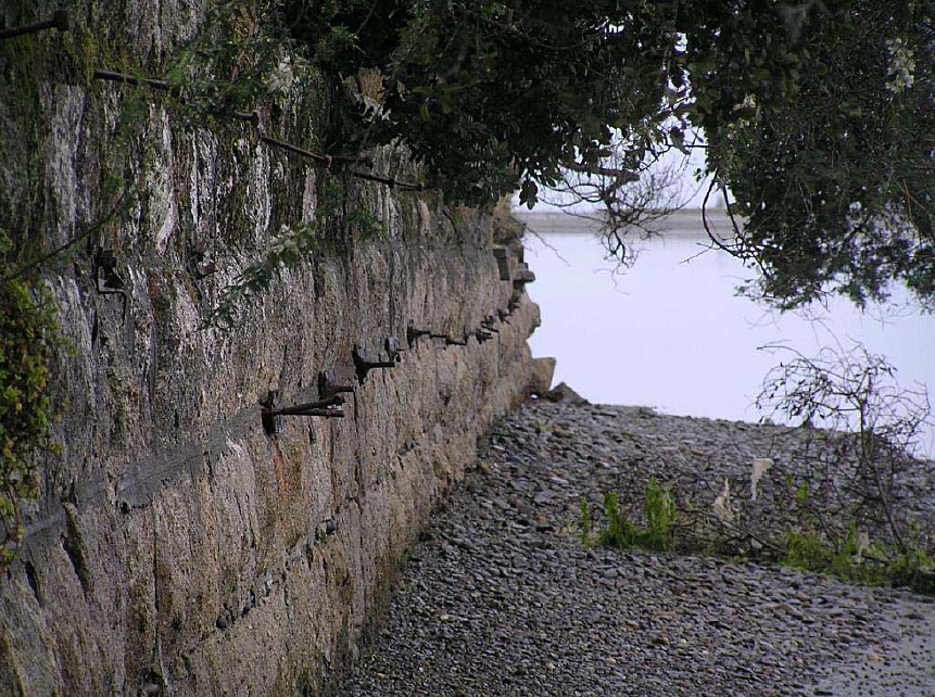
The construction of the Motueka Wharf in 1887 was a family affair with William Akersten designing the structure and Myles Akersten contracted by the provincial government to build it. The cost of the structure was approximately £4,000, for which a substantial loan was taken out, and the design included a stone causeway to build up the land end of the wharf that then had a timber pile wharf extending further into the harbour. This part of the wharf featured the wharf offices and was where the coastal vessels moored. The granite causeway featured a tramway that led to the warehouses and factories surrounding the wharf area and also provided direct access to the ships for horse and cart traffic.
It is perhaps not surprising that when designing the Motueka Wharf, a structure which would have to be robust and durable given its environment, Akersten chose to use local granite available at Astrolabe and Torrent Bays for the main causeway. The exploitation of the significant mineral resources of the area around the Tasman district has a long history. Maori established several argillite quarries around Motueka from the thirteenth century. This was a prized resource because it was perfect for the fashioning of hardy tools. Nelson province continued to be noted for its mineral resources after European settlement began and high profile buildings as Parliament House in Wellington are constructed from the region's stone. In particular, granite was sometimes used locally for building piles. Granite was also used for significant structures such as the Church Steps in Nelson and in the Public Trust Office Building, Wellington, and this stone, originating from Tonga Bay, has the distinction of being regarded as New Zealand's only true granite.
Motueka Wharf enabled increased coastal shipping capacity. Because of the lack of other efficient modes of transport this facility was essential to the area's growth, and the wharf was a vital portal for cargo and passenger conveyance and other services such as mail circulation. Because of this latter role there was a post office and telephone exchange directly adjacent to the end of the causeway. Because of these factors the wharf was consistently busy and bustling with people, be they wharfingers, ships crew, delivery staff, embarking or disembarking passengers, and people gathered to meet or farewell the former.
While an early focus of the local economy was agricultural, by the 1880s the fruit growing and processing industry in Motueka had been established on a small scale. An example of the extent of this is that one company produced approximately five tons of jam in 1881. But with the aid of the wharf by 1895 Motueka, along with Stoke, was considered a leading fruit growing and processing area in Nelson province, which in turn was recognised as the predominant berry-fruit growing region in New Zealand. Coastal shipping access was crucial for the agricultural industry in particular due to the perishable nature of much of the product and the associated need for efficient transportation. The importance and growth of this and other local industries during this period motivated the Motueka Wharf Board, who took ownership of the wharf in 1902, to immediately upgrade the facilities by extending of the timber section of Motueka Wharf.
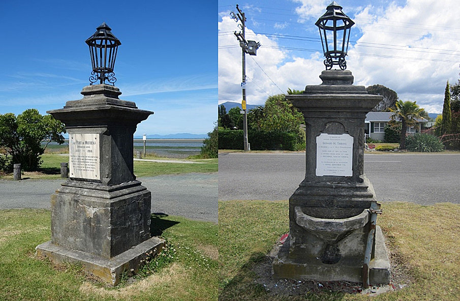
The period around 1902 was not only a time of change at the port, but also for the British Empire. This was represented at Motueka Wharf with the construction of a commemorative monument. Because Motueka Wharf was the major point of entry and exit to the town, and therefore a high profile spot, it was an appropriate location for a memorial. However, this choice of site was also tied in with the fact that residents had been petitioning the County Council to construct a drinking fountain and light at the wharf in 1900. It seems that the suggested addition of a plaque recognising the sacrifice of Trooper Tarrant, who died in the South African War and was the son of a prominent local man, to the already proposed structure was an astute manoeuvre to progress the project. From this time the focus of the project, which was initiated and promoted by wharfinger H.L. Moffat, became the construction of a memorial. By framing the project like this Trooper Tarrant could be genuinely honoured but, as a return for their generosity towards the memorial fund, the public could also expect to benefit through the addition of wharf utilities which the County Council was slow to grant.
Originally, contributions towards the Trooper Tarrant memorial began to be collected in 1901, approximately a year before the South African War was finished. However, the process stalled until the next year with only half of the £37 cost collected. At this time the project was resurrected because it was felt that: The time is ripe for it just now, for with memories associated with a happy termination of the war, and the enthronement of King Edwards after a period of anxiety and suspense through illness, loyal subjects will all the more readily contribute.
Therefore, in order to raise further the necessary funds the scope of the monument's dedication was expanded to include a celebration of both the end of the war and the accession of the new King. This appears to have been an accurate reading of the climate because almost all of the balance of the cost had been raised when the memorial was unveiled at a ceremony on 8 July 1903.
A large gathering of local people and dignitaries, as well as mounted troops, were in attendance at the unveiling ceremony. The monument was described as 'an excellent piece of masonry, the work of Miller and Sons, Nelson.' The concrete structure was surmounted with a lamp, and on the wharf side it had a marble plaque dedicating the monument to the memory of Leonard M. Tarrant, the end of the South African War, and to the accession of King Edward VII. A water trough on the monument benefitted the numerous horses that were used to cart goods at the wharf. The human traffic at the wharf was not forgotten either as there was a fountain on the opposite side, which was greatly appreciated by those who worked at the wharf. These features fulfilled the functional purpose which had been the initial motivation for the memorial project.
In 1905 the Motueka Wharf Board was incorporated and became known as the Motueka Harbour Board. Because Motueka was a shallow-draught port much of the income of the Motueka Harbour Board was derived from outward bound local fruit, timber and tobacco. In particular, fruit growing increased rapidly in the early years of the twentieth century with shipments from the wharf doubling between 1911 and 1915. This boom in the industry saw many companies build packing facilities and cool stores in close proximity to the wharf. A particular coup for Motueka was the presence of the Nelson District Fruitgrowers' Association's cider, vinegar, apple drying and preserving factory near Motueka Wharf. The company opted to base itself in Motueka and not Nelson when its proposal to build a private siding to the city's port was denied. Other company's such as St George Co. Ltd. also had a canning and jam making plant nearby, but like the Nelson District Fruitgrowers' Association's they were compelled to move their factory when a new wharf came into use in 1916.
In the early years of the twentieth century the booming local horticultural industries, which the wharf had assisted in developing, were beginning to place a demand on the wharf facilities that could not continue to be met with the existing structure and, like the first wharf at Motueka, its shortcomings began to be highlighted and lamented publically. This resulted in the Motueka Harbour Board entreating the Marine Department to pay £13,000 to extend the wharf and dredge the harbour. This cost was dismissed by the government as untenable considering the size of the district. Therefore, the Harbour Board was forced to consider more cost effective solutions which could provide improved services to the local region, and within a decade they launched an extensive building programme that would see a new wharf built at a location in the Moutere Inlet. The new wharf was operative in 1916 and it then became the focus of the areas transport and industrial processing facilities, rendering Motueka Wharf, and the surrounding industrial area, largely redundant. However, later a plaque was attached to the memorial at Motueka Wharf to commemorate the use of the area as the early port of the town.
Despite the creation of the new wharf, Motueka Wharf continued to be owned by the Motueka Harbour Board, but was not used as part of their operations and the buildings on the wharf were removed. Because of the new facilities Motueka Wharf was not maintained to the level it had been previously and between 1919 and 1925, the last time it appears as an asset of the Motueka Harbour Board, the value of the structure diminished from £700 to £225.
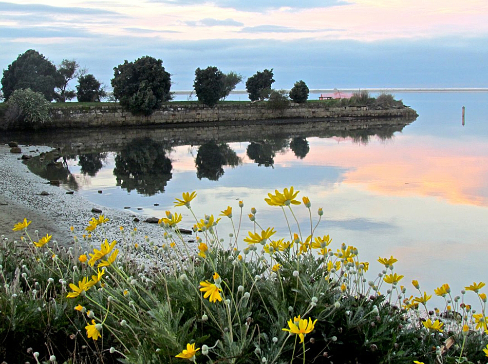
It would appear that from this time onwards the timber sections of the wharf were left to degrade. The causeway fared better than the timber section of Motueka Wharf because of its construction materials and has subsequently been incorporated into a popular picnic and recreational area which evolved as the tenor of the area changed from industrial to residential. Aside from the wharf, other key features of this picturesque area include a beachside walkway and the wreck of the Janie Seddon. This ship was built in 1901 for the New Zealand Defence Department and later acquired by Talleys who converted it into a fishing vessel. In 1953 it was beached at its current location, close to Motueka Wharf, after it sunk while in its moorings.
The heritage and social values of the wharf have long been recognised locally and in 2006 a project, led by Tasman District Council and supported by community groups such as Keep Motueka Beautiful, was launched to restore the structure starting with the commissioning of a conservation plan. As yet the recommendations in this report have not been implemented. However, the co-owners of the land and structure, Department of Conservation and the Council, are endeavouring to complete the project in the near future.