

Teviot Station was developed by Captain John Cargill and his brother-in-law, E.R. Anderson, during the 1860s and 1870s. Cargill, who was the eldest son of Captain William Cargill, co-founder of the Dunedin settlement, applied for the lease of Run 199 (Teviot) in 1857 and by 1871 the property carried over 42,000 sheep on 64,000 acres of land on both sides of the Clutha River. Earlier Cargill had leased a run closer to Dunedin but after it had been declared a goldfield by the Otago Provincial Government he devoted his energies to the Teviot run which subsequently became the largest in the Tuapeka district.
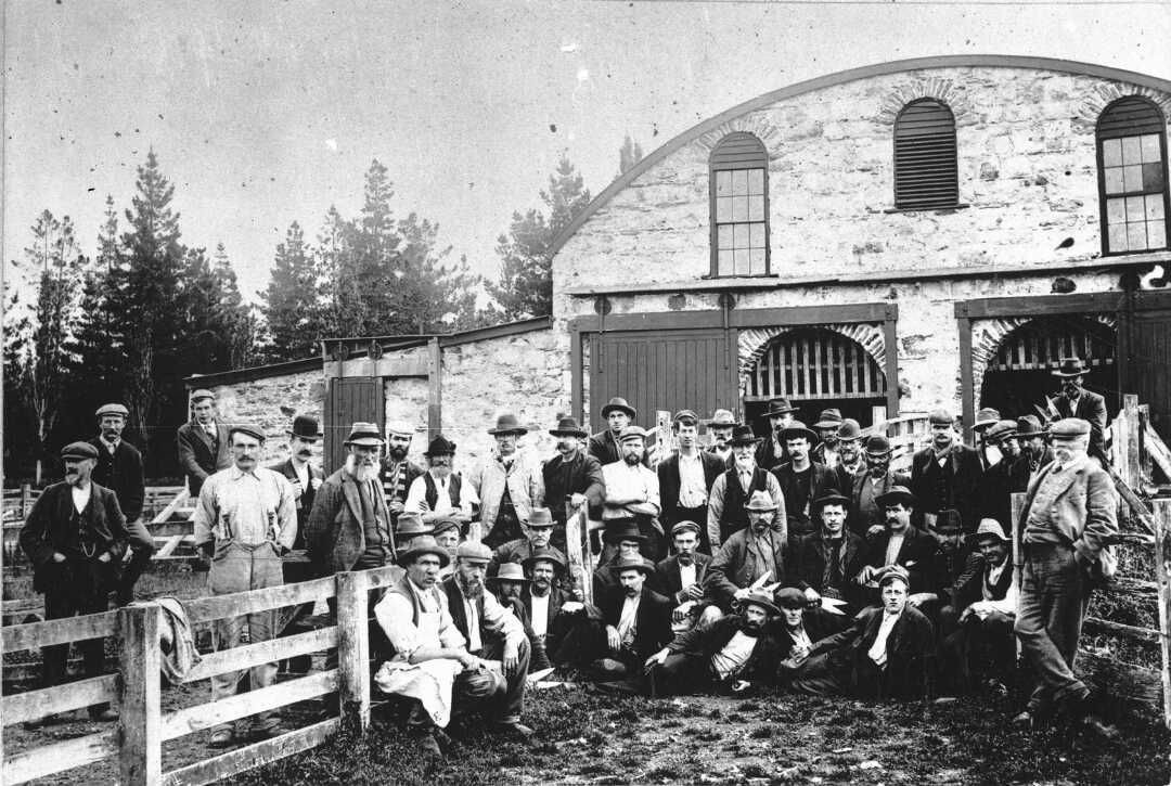
In 1880 the woolshed was erected near the station's homestead and it is thought that Anderson imported the roof and trusses from England where they had been used in a temporary railway station; although it has also been suggested that the ironwork and roofing came from the Glasgow Exhibition. The woolshed's location at the extreme south-east corner of the station added considerably to the workload of the property's shepherds and a shed was therefore built on the opposite side of the Clutha River to handle the stock on that part of the run. Interestingly this building was used for many different purposes, among them as a venue for church services.
Flooding and severe rabbit infestations greatly undermined the profitability of the big Otago runs in the late nineteenth century and from the early 1880s Teviot was gradually broken up into smaller holdings. Cargill and Anderson eventually sold their interests in the station and both men subsequently left New Zealand. The principal woolshed at Teviot was burnt down on 11 November 1924 and, as there was no longer any need for such a huge shed on the reduced homestead block, it was never reinstated.
List Entry Information
Status
Listed
List Entry Status
Historic Place Category 1
Access
Private/No Public Access
List Number
336
Date Entered
14th February 1991
Date of Effect
14th February 1991
City/District Council
Central Otago District
Region
Otago Region
Extent of List Entry
The extent includes part of the land described as Lot 1 DP 339179 (RT 161212), Otago Land District, and the structure known as the Teviot Station Woolshed Ruins thereon.
Legal description
Lot 1 DP 339179 (RT 161212), Otago Land District
Why is this place significant?
Historic Significance
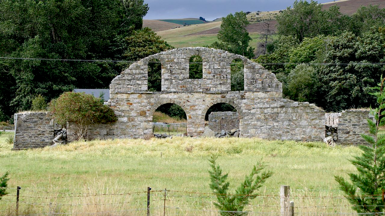
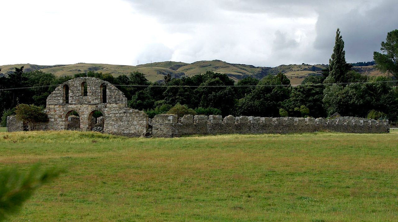
Historical Significance or Value The ruins of the Teviot Station woolshed stand as a visible reminder of the massive scale of South Island sheep farming in the late nineteenth century.
Physical Significance
ARCHITECTURAL QUALITY: With an estimated capacity of 8000 sheep the Teviot Station woolshed was the largest ever built in New Zealand and at one time it may have also been the largest single storey woolshed in the southern hemisphere. Built from Otago schist, which was readily available and easily quarried in an area where timber was scarce, and with a roof structure that had previously served as a temporary railway station in England (see below), the woolshed was one of a number of farm buildings erected by Cargill and Anderson to serve their huge property. Today the architectural quality of the building resides in the contribution it makes to our understanding of nineteenth century woolshed construction. The impressive size and scale of the ruins (and the type of construction) are on a gigantic scale for New Zealand conditions, even when compared with contemporary structures like the Morven Hills Woolshed in the Lindis Valley which boasts 34 shearing stands. TOWNSCAPE/LANDMARK VALUE: Standing against a backdrop of low hills, and completely overshadowing a nearby group of stone and timber farm buildings, the woolshed is the most extensive stone ruin in New Zealand and makes a dramatic contribution to the Central Otago landscape.
Why is this place significant?
Historic Significance
Historical Significance or Value The ruins of the Teviot Station woolshed stand as a visible reminder of the massive scale of South Island sheep farming in the late nineteenth century.
Physical Significance
ARCHITECTURAL QUALITY: With an estimated capacity of 8000 sheep the Teviot Station woolshed was the largest ever built in New Zealand and at one time it may have also been the largest single storey woolshed in the southern hemisphere. Built from Otago schist, which was readily available and easily quarried in an area where timber was scarce, and with a roof structure that had previously served as a temporary railway station in England (see below), the woolshed was one of a number of farm buildings erected by Cargill and Anderson to serve their huge property. Today the architectural quality of the building resides in the contribution it makes to our understanding of nineteenth century woolshed construction. The impressive size and scale of the ruins (and the type of construction) are on a gigantic scale for New Zealand conditions, even when compared with contemporary structures like the Morven Hills Woolshed in the Lindis Valley which boasts 34 shearing stands. TOWNSCAPE/LANDMARK VALUE: Standing against a backdrop of low hills, and completely overshadowing a nearby group of stone and timber farm buildings, the woolshed is the most extensive stone ruin in New Zealand and makes a dramatic contribution to the Central Otago landscape.
Construction Details
Start Year
1924
Type
Other
Description
Fire destroyed roof, clerestory wall structure and upper section of the north wall
Start Year
1880
Type
Original Construction
Construction Materials
Random rubble masonry construction; Otago schist used in blocks and slabs.
Notable Features
The monumental size and scale of the Teviot woolshed ruins.
ARCHITECT/ENGINEER/DESIGNER: It is not known who was responsible for the design and/or construction of the woolshed at Teviot Station. However, E.R. Anderson, joint owner of the property in 1880, is said to have purchased the roof structure while on a visit to England and it is therefore possible that he had a hand in the building's design. ARCHITECTURAL DESCRIPTION: The former Teviot Station woolshed ruins stand near the east bank of the Clutha River, approximately eight kilometres south-east of Roxburgh. Largely destroyed by fire in 1924, the woolshed was a huge single-storeyed building with forty shearing stands arranged in two rows within a barrel vaulted "nave" which was lit and/or ventilated by a clerestory and flanked by "aisles" with lean-to roofs. All that remains of the building today, however, is the stonework of the exterior walls which forms a rectangle measuring 135 metres in length and 46.5 metres in width. The dominant feature of this monumental structure is the two-storeyed arched section, set within the south-facing end wall, which reveals the size and shape of the main roof. Pierced by three large window openings and two massive doorways the arch was originally echoed by a weather boarded section at the opposite end of the building. Forming an unbroken link between these walls the external wall of each "aisle" is pierced at regular intervals by twenty window openings and a similar number of drainage vents at the base of each wall. A large opening in the north wall provides easy access to the interior of the ruins and, although nearly all evidence of the fire which destroyed the woolshed has since been removed from the site, it is still possible to detect remnants of the building's wooden window sills and the metal bolts which once tied the structure together. Most of the wall structure of the former woolshed is made up of slabs of schist which are embedded in a coarse mortar but the external surface of the south wall and those sections of the side walls which form the window jambs are clad in larger and more regular blocks of stone. In addition to this variation in the stonework it would appear that the entire surface of the building was originally covered with a layer of mud, and some of this cladding is still extant on the north wall. MODIFICATIONS: 1924 - Fire destroyed roof, clerestory wall structure and upper section of the north wall.
ARCHITECT/ENGINEER/DESIGNER: It is not known who was responsible for the design and/or construction of the woolshed at Teviot Station. However, E.R. Anderson, joint owner of the property in 1880, is said to have purchased the roof structure while on a visit to England and it is therefore possible that he had a hand in the building's design. ARCHITECTURAL DESCRIPTION: The former Teviot Station woolshed ruins stand near the east bank of the Clutha River, approximately eight kilometres south-east of Roxburgh. Largely destroyed by fire in 1924, the woolshed was a huge single-storeyed building with forty shearing stands arranged in two rows within a barrel vaulted "nave" which was lit and/or ventilated by a clerestory and flanked by "aisles" with lean-to roofs. All that remains of the building today, however, is the stonework of the exterior walls which forms a rectangle measuring 135 metres in length and 46.5 metres in width. The dominant feature of this monumental structure is the two-storeyed arched section, set within the south-facing end wall, which reveals the size and shape of the main roof. Pierced by three large window openings and two massive doorways the arch was originally echoed by a weather boarded section at the opposite end of the building. Forming an unbroken link between these walls the external wall of each "aisle" is pierced at regular intervals by twenty window openings and a similar number of drainage vents at the base of each wall. A large opening in the north wall provides easy access to the interior of the ruins and, although nearly all evidence of the fire which destroyed the woolshed has since been removed from the site, it is still possible to detect remnants of the building's wooden window sills and the metal bolts which once tied the structure together. Most of the wall structure of the former woolshed is made up of slabs of schist which are embedded in a coarse mortar but the external surface of the south wall and those sections of the side walls which form the window jambs are clad in larger and more regular blocks of stone. In addition to this variation in the stonework it would appear that the entire surface of the building was originally covered with a layer of mud, and some of this cladding is still extant on the north wall. MODIFICATIONS: 1924 - Fire destroyed roof, clerestory wall structure and upper section of the north wall.
Historical and Associated Iwi / Hapū / Whānau
Information Sources
Beattie, 1979
JH Beattie, The Southern Runs, Gore Historical Society, Invercargill, 1979
Eldred-Grigg, 1980
Stevan Eldred-Grigg, A Southern Gentry: New Zealanders Who Inherited the Earth. A H and A W Reed, New Zealand, 1980.
Mayhew, 1949
W.R. Mayhew, Tuapeka: The Land and Its People: A Social History of the Borough of Lawrence and its Surrounding Districts, Otago Centennial Historical Publications, Dunedin, 1949
Thornton, 1986
Geoffrey Thornton, The New Zealand Heritage of Farm Buildings, Auckland, 1986
Webster, 1948
A. H. H. Webster, Teviot Tapestry. A History of the Roxburgh-Millers Flat District. Whitcombe & Tombs / Otago Centennial Historical Publications, Otago, 1948
Other Information
This historic place was registered under the Historic Places Act 1980. This report includes the text from the original Building Classification Committee report considered by the NZHPT Board at the time of registration. Please note that entry on the New Zealand Heritage List/Rarangi Korero identifies only the heritage values of the property concerned, and should not be construed as advice on the state of the property, or as a comment of its soundness or safety, including in regard to earthquake risk, safety in the event of fire, or insanitary conditions.
Former Usages
General Usage: Agriculture
Specific Usage: Woolshed/Shearing Shed
Former Usages
General Usage: Agriculture
Specific Usage: Woolshed/Shearing Shed
Location
Stay up to date with Heritage this month
