

Kopuāranga has its origins in a camp established in 1872 for Scandinavian migrants who came to Aotearoa New Zealand to labour on public works projects in exchange for free passage and land, as part of a major government immigration drive. They were enlisted to fell the vast forest Te Tāpere Nui ō Whātonga, called Seventy Mile Bush by Pākehā, and lived for a couple of years in what became known as ‘Scandinavian Camp’. The camp evolved into a permanent settlement called Dreyerton, and later, Kopuāranga. Education was an early concern and teachers were sent to instruct the camp’s children. After community lobbying, the Wellington Education Board agreed to build a public school.
Constructed by Masterton builder John Montgomery, Kopuāranga School (Former) began life as a one room building with a modest porch entrance topped by a small belfry and steeple. Among its most distinctive architectural features were a series of double-hung eight paned sash windows with rounded mouldings and corbels under the sill, a design motif Turnbull repeated at other Wairarapa schools. A second classroom and lean-to kitchen were added in 1897.
The belfry was damaged in the 1942 Wairarapa earthquakes and was dismantled early the following decade. The bell was salvaged and installed in a stand-alone bell tower erected in the grounds in 1960, the school’s 75th anniversary. The most significant change to the building’s physical appearance occurred the previous year, when a large bank of casement windows was installed in the north-east elevation. Kopuāranga School (Former) closed in 1975 due to a long-standing decline in the roll. It was declared a recreational reserve in 1981 and has been managed by the Kopuāranga Hall Society since then.
List Entry Information
Status
Listed
List Entry Status
Historic Place Category 2
Access
Able to Visit
List Number
4017
Date Entered
15th April 2020
Date of Effect
7th May 2020
City/District Council
Masterton District
Region
Wellington Region
Extent of List Entry
Extent includes the land described as Sec 86 Opaki District (NZ Gazette 1981 p.851), Wellington Land District and the building known as Kopuāranga School (Former) and its outbuildings thereon, the southwest boundary of the List entry being the trees which mark the boundary between the school land and the private parcel known as Lot 1 DP 18138 (WN25C/835). (Refer to map in Appendix 1 of the List entry report for further information).
Legal description
Sec 86 OPAKI District (NZ Gazette 1981 p.851), Wellington Land District
Location Description
GPS (outside the gate): E1824201, N5476280, +-4m
Why is this place significant?
Cultural Significance
Social Significance or Value The social value of Kopuāranga School (Former) is demonstrated by the work of the local community to have the place designated a recreation reserve following the closure of the school in 1975. While it is now a private residence, the building is managed by the Kopuāranga Hall Society, which creates an enduring connection with the Kopuāranga community and functions as a reminder of the school’s historic role at the centre of this community.
Historic Significance
Historical Significance or Value Kopuāranga School (Former) has historical significance for its connection to Scandinavian migrants and communities in nineteenth century Aotearoa New Zealand. Purpose-built for education, it represents the successful efforts of this community to put down permanent roots in the district by constructing essential institutions like schools. Designed by Thomas Turnbull, it retains characteristic design features of his rural Wairarapa schools, most significantly the rounded mouldings of the double-hung sash windows, and is a largely intact example of this noted nineteenth century architect’s educational work. Furthermore, it exemplifies the typical late nineteenth century school – rural and small. The 1935 commemorative gates highlight the general respect with which the monarchy was held in at this time.
Why is this place Category 1 / Category 2?
Detail Of Assessed Criteria
This place was assessed against all criteria, and found to qualify under the following: a, b and e. It is considered that this place qualifies as a Category 2 historic place. (a) The extent to which the place reflects important or representative aspects of New Zealand history Kopuāranga School (Former) has its origins in the Scandinavian community that settled in the district in the early 1870s following a major government-sponsored immigration campaign, and reflects the critical importance of migration in the history of nineteenth century Aotearoa New Zealand. It also demonstrates the importance of educational facilities in the establishment of new settlements by migrant communities. As a school built in the early years of free, compulsory and secular education, it is a reminder of one of the most significant developments in the history of education in this country. Though no longer a school, it is largely intact and retains the two-classroom layout set in place in 1897. The building sits on the original land parcel and is surrounded by ancillary educational outbuildings and amenities. (b) The association of the place with events, persons, or ideas of importance in New Zealand history As the work of leading nineteenth century architect Thomas Turnbull, Kopuāranga School (Former) is directly associated with a significant figure in New Zealand history. Turnbull designed a wide range, both in scale and purpose, of buildings, and this place is testament to the versatility of his architectural practice. The rounded mouldings of the school’s windows are a known Turnbull motif and are among its most prominent features. (e) The community association with, or public esteem for the place Though owned by the Department of Conservation, Kopuāranga School (Former) is managed by the Kopuāranga Hall Society, an arrangement that came about after community lobbying ensured the building was declared a recreational reserve when it closed. The community has found new uses for the building, guaranteeing its preservation as an important local place. Its inclusion on a Scandinavian heritage trail devised by the Friends of Mauriceville group demonstrates its historic associations are recognised by the community and members of the general public.
Construction Professional
Name
Turnbull, Thomas
Type
Architect
Biography
Thomas Turnbull (1824-1907) was born and educated in Scotland and trained under David Bryce, Her Majesty's Architect. He travelled to Melbourne in 1851 and after nine years there moved to San Francisco. He arrived in New Zealand in 1871 and soon established a thriving business. His son William, a distinguished architect in his own right, became a partner in the firm in 1891. Turnbull was a member of the Royal Institute of British Architects. He was a pioneer in the design of buildings to withstand earthquakes and he was responsible for breaking down prejudice against the use of permanent materials for building construction. He specialised in masonry construction for commercial purposes but was also responsible for some fine houses. Among his most important buildings were the Willis Street churches of St Peter (1879) and St John (1885), the former National Mutual Building (1883-84), the General Assembly Library (1899) and the former Bank of New Zealand Head Office (1901), all in Wellington.
Name
Montgomery, John
Type
Builder
Biography
No biography is currently available for this construction professional
Name
Daniell, Charles Edward
Type
Builder
Biography
Daniell emigrated to New Zealand and settled in the Wairarapa in 1880 at the age of 24. He had learned building skills in England and began constructing bridges in the Wairarapa. Throughout the following years he designed and built many of the Wairarapa's large homesteads and farm buildings. He set up a timber mill for a ready supply of timber and then a hardware store. This store survived as "C.E. Daniell's" until the mid 1980s. Such ventures meant that Daniell was the largest employer in the Wairarapa for many years. In addition to this he worked extensively in the community, chairing several school Boards, an orphanage and the Wellington Harbour Board among other organizations. He was responsible for Awatoitoi Homestead, Blairlogie (1907-12) and Annandale Station woolshed.
Name
Symmans, H. L.
Type
Architect
Biography
Responsible for designing modifications to the Kopuaranga School near Masterton, in the 1950s. Source: Listing report March 2020.
Construction Details
Type
Addition
Description
Addition of a second entrance porch
Period
1960s
Type
Addition
Description
Addition of mezzanine level to the 1897 classroom
Period
1990s
Start Year
1885
Type
Original Construction
Start Year
1897
Type
Addition
Description
An addition of a new classroom and lean-to.
Start Year
1953
Type
Modification
Description
Bellcote from above the entrance was removed
Start Year
1959
Type
Modification
Description
New windows installed in the north-east elevation
Construction Materials
Timber, corrugated iron
Tangata Whenua Wairarapa has a lengthy history of Māori occupation stretching back to the late 1300s, when Palliser Bay was settled. Within around 200 years these coastal settlements were abandoned and some people may have settled inland. Early iwi groups were Waitaha and Ngāti Mamoe and they were followed in the 1600s by Rangitāne, Ngāti Ira and Ngāti Kahungunu, all of whom migrated south to settle in Wairarapa. Ngāti Ira subsequently moved further south to Te Whanganui-a-Tara/Wellington but Rangitāne and Ngāti Kahungunu established deep roots in the region and forged peaceful relations through intermarriage and diplomacy in an enduring agreement known as ‘Te Rerewa’. Wairarapa was one of the conflict zones in the ‘musket wars’ period of the early nineteenth century and was invaded many times, firstly by Ngāti Whātua and Ngāti Maniapoto in 1821 and Taranaki tribes Ngāti Tama and Te Āti Awa the following decade. Rangitāne and Ngāti Kahungunu both left the region for safer places. The negotiation of a peace treaty between the Ngāti Kahungunu rangatira Tūtepākihirangi and his Te Ātiawa counterpart Te Wharepouri saw the return of Rangitāne and Ngāti Kahungunu to Wairarapa in the early 1840s. European settlement of Wairarapa began in 1844, when Wellington colonists leased land from Ngāti Kahungunu for pastoral farming. The government started buying land in 1853 and the first colonists arrived in the new towns of Masterton and Greytown in 1854. Featherston was founded in 1856, followed by Martinborough in 1870. Government attention soon turned to the vast forest Te Tāpere Nui ō Whātonga, named after the ancestor Whātonga, which covered the land between Kopuāranga and Rākautatahi in the northern reaches of Wairarapa. Ngāti Hāmua, a hapu of Rangitāne, had traditionally occupied the clearings and harvested the natural resources of the forest and its waterways. Known to colonists as Seventy Mile Bush, from the 1870s it was the target of an ambitious government assisted migration and public works programme, which resulted in the almost wholesale destruction of the forest by 1910. Numerically, the 1870s migration period was ‘the most significant in New Zealand history’. Dreyertown In 1871 government agent Bror Erik Friberg was sent to Norway and Sweden to enlist migrants by offering cheap land and assisted travel to New Zealand in exchange for public works labour. In 1872 the ship England arrived in Wellington with some of Friberg’s recruits. They were sent to Wairarapa where they set about clearing Te Tāpere Nui ō Whātonga. The immigrants lived in primitive huts in a settlement at Kopuāranga colloquially known as the ‘Scandinavian Camp’. This was supposed to be a short stop before the migrants were settled on their own land, but this had not been surveyed and the camp was home for a couple of years. Alexander Dreyer (1820-1905) was the government agent and camp storekeeper. He became a well-known character, once accidentally using 28 pounds of dynamite at once to uproot tree stumps. Scandinavian Camp was renamed ‘Dreyer’s Town’, which morphed into Dreyertown and eventually, Dreyerton. Larger towns founded by the Scandinavian migrants were nearby Mauriceville and Eketāhuna, with Norsewood and Dannevirke further north in the present-day Tararua district. Education The camp community asked for a schoolmaster to be provided by the government so the children could learn English. A schoolmaster was provided but by 1874 a replacement was soon sought, as the teacher appointed ‘had shown a preference for tilling his own land rather than keeping school’. By 1875 there were about 30 children of school age at the camp. Free, secular and compulsory education was instituted in 1877 and over three-quarters of the public primary schools at this time were small rural schools, with one or two classrooms and the same number of teachers. In July 1882 the Dreyerton community presented a petition to the Wellington Education Board asking for a public school building and the Board finally agreed 18 months later. In December 1884 tenders were invited for the construction of a school by architect Thomas Turnbull. Thomas Turnbull Thomas Turnbull (1825-1907) had recently been appointed the Board’s architect. Born in Glasgow, Scotland, he became a building apprentice and from 1842 worked with noted Scottish architect David Bryce. In 1851 he left for Australia and was an architect in gold-mining towns. Ten years later, Turnbull moved to San Francisco, where he undertook a number of notable commissions. By 1871 failing health saw him undertake a rest cure in New Zealand. He settled in Wellington and became an assistant to the Colonial Architect William Clayton. The following year he set up his own architectural practice, and designed major Wellington buildings such as St Peter’s Church (1879, List No. 229), St John’s Church (1885, List No. 228), the Bank of New Zealand Head Office (1889, List No. 212) and the General Assembly Library (1899, List No. 217). Dreyerton School In January 1885 Masterton builder John Montgomery won the tender for Dreyerton School with a contract price of £249. Turnbull’s design for the new school, a modest 394 square feet (36.6 square metres) in size, was a simple single storey timber building comprised of one room with a gable roof, a design typical of rural schools in this period. Surmounting the gabled entrance porch was a small belfry topped with a steeple. The porch had one double-hung eight paned sash window on the north-east elevation with rounded top corners and corbels under the sill, and this was likely replicated on the south-west elevation. The main north-east and south-west elevations each had two of these windows, which were a distinguishing characteristic of Turnbull’s and seen on other Wairarapa schools he designed in the 1880s, including Mauriceville West, Te Whiti, Eketāhuna, Tīnui and Featherston. Tīnui, Featherston and Mauriceville West also had similar porches. Dreyerton School opened on 20 May 1885, with 19 pupils. By the end of the first quarter there were 22 girls and 25 boys on the roll. As was common practice at the time, girls and boys sat on different sides of the classroom and had separate playgrounds. Small sheds were built in the grounds in 1885 and 1887 to provide the children with shelter during hot or wet weather. Outside of school hours the building was used for events, such as social evenings and election meetings. In April 1897, after numerous requests by the school committee, the Board agreed to fund an additional classroom to accommodate a growing roll. The contract was let to Masterton builder C. E. Daniell. The new classroom was built at a right angle to the original school room, forming an L shape, and a lean-to kitchen was attached to the front of this alongside the existing porch. Both new additions had double-hung sash windows that mirrored the originals in style. The total addition was 618 square feet (57.4 square metres), and the school was now 1012 square feet (94 square metres) in total. New Name By the early 1900s, the settlement’s name was being reconsidered. The school, the post office and church were named Dreyerton but the railway station was called Kopuāranga, as was the survey district in which the township was located, and a nearby river. In mid-1906, at the school committee’s request, the Board changed the name of the school from Dreyerton to Kopuāranga in line with the settlement. Building Changes In 1932 new ridging was put on the school’s roof and two years later, C. E. Daniell was contracted to lower the windows in the main school room and move two windows in the south-western wall to the north-western wall to allow more light into the rooms. In celebration of the King George V’s silver jubilee in 1935, commemorative gates were built at the front entrance of the school. Funds for the gates were raised by locals and the fence and posts were built ‘by a dozen men of the district’ at working bees. The official opening was a brief affair due to bad weather but the event was suitably marked by an evening concert and dance at the local hall up the road. A significant achievement of the 1940s was the installation of electric lighting in 1942. The belfry was damaged in a major earthquake that year and remained in a precarious state until it was dismantled in 1953. Parts from the tower were used to build a milk stand at the front gate. In 1959, under the supervision of architect H.L. Symmans, the school building was modernised by the addition of a large bank of windows on the north-eastern elevation, which replaced the two original double-hung sash windows and provided plenty of fresh air. The lean-to may also have had sinks and a zip added. In 1960 a free-standing bell tower was built in the grounds to commemorate the school’s 75th anniversary. The original bell from the dismantled belfry had been kept and this was installed in the new tower. During the 1960s a small entrance porch was added to the front original porch. Closure The school roll had sat in the mid-20s to mid-30s since the 1920s and struggled to maintain double figures by the 1960s. With such small numbers, the school was particularly vulnerable when rural economic downturn caused families to move out of the district. By early 1970 the school roll stood at eleven pupils and the following year the Wellington Education Board proposed shifting the form one and two pupils to a Masterton intermediate school. This did not eventuate but, in the words of the district’s centennial publication, ‘the writing was on the wall. We knew it – and the Board knew it.’ Kopuāranga School closed on 19 December 1975 and its remaining pupils went to nearby Ōpaki School the following year. The Kopuāranga Hall Society, which administered both the local hall and a closed church, asked the Ministry of Education for the land and buildings to be classified as a reserve with the society appointed as an administering body. The site was duly classified under the Reserves Act 1977 and the Kopuāranga Hall Society was appointed to ‘control and manage’ the reserve in 1980. The school became the home of the Wairarapa Vintage Car Club and, later, a private residence and artist’s studio. It is now one on a Scandinavian heritage trail devised by the group Friends of Mauriceville.
Tangata Whenua Wairarapa has a lengthy history of Māori occupation stretching back to the late 1300s, when Palliser Bay was settled. Within around 200 years these coastal settlements were abandoned and some people may have settled inland. Early iwi groups were Waitaha and Ngāti Mamoe and they were followed in the 1600s by Rangitāne, Ngāti Ira and Ngāti Kahungunu, all of whom migrated south to settle in Wairarapa. Ngāti Ira subsequently moved further south to Te Whanganui-a-Tara/Wellington but Rangitāne and Ngāti Kahungunu established deep roots in the region and forged peaceful relations through intermarriage and diplomacy in an enduring agreement known as ‘Te Rerewa’. Wairarapa was one of the conflict zones in the ‘musket wars’ period of the early nineteenth century and was invaded many times, firstly by Ngāti Whātua and Ngāti Maniapoto in 1821 and Taranaki tribes Ngāti Tama and Te Āti Awa the following decade. Rangitāne and Ngāti Kahungunu both left the region for safer places. The negotiation of a peace treaty between the Ngāti Kahungunu rangatira Tūtepākihirangi and his Te Ātiawa counterpart Te Wharepouri saw the return of Rangitāne and Ngāti Kahungunu to Wairarapa in the early 1840s. European settlement of Wairarapa began in 1844, when Wellington colonists leased land from Ngāti Kahungunu for pastoral farming. The government started buying land in 1853 and the first colonists arrived in the new towns of Masterton and Greytown in 1854. Featherston was founded in 1856, followed by Martinborough in 1870. Government attention soon turned to the vast forest Te Tāpere Nui ō Whātonga, named after the ancestor Whātonga, which covered the land between Kopuāranga and Rākautatahi in the northern reaches of Wairarapa. Ngāti Hāmua, a hapu of Rangitāne, had traditionally occupied the clearings and harvested the natural resources of the forest and its waterways. Known to colonists as Seventy Mile Bush, from the 1870s it was the target of an ambitious government assisted migration and public works programme, which resulted in the almost wholesale destruction of the forest by 1910. Numerically, the 1870s migration period was ‘the most significant in New Zealand history’. Dreyertown In 1871 government agent Bror Erik Friberg was sent to Norway and Sweden to enlist migrants by offering cheap land and assisted travel to New Zealand in exchange for public works labour. In 1872 the ship England arrived in Wellington with some of Friberg’s recruits. They were sent to Wairarapa where they set about clearing Te Tāpere Nui ō Whātonga. The immigrants lived in primitive huts in a settlement at Kopuāranga colloquially known as the ‘Scandinavian Camp’. This was supposed to be a short stop before the migrants were settled on their own land, but this had not been surveyed and the camp was home for a couple of years. Alexander Dreyer (1820-1905) was the government agent and camp storekeeper. He became a well-known character, once accidentally using 28 pounds of dynamite at once to uproot tree stumps. Scandinavian Camp was renamed ‘Dreyer’s Town’, which morphed into Dreyertown and eventually, Dreyerton. Larger towns founded by the Scandinavian migrants were nearby Mauriceville and Eketāhuna, with Norsewood and Dannevirke further north in the present-day Tararua district. Education The camp community asked for a schoolmaster to be provided by the government so the children could learn English. A schoolmaster was provided but by 1874 a replacement was soon sought, as the teacher appointed ‘had shown a preference for tilling his own land rather than keeping school’. By 1875 there were about 30 children of school age at the camp. Free, secular and compulsory education was instituted in 1877 and over three-quarters of the public primary schools at this time were small rural schools, with one or two classrooms and the same number of teachers. In July 1882 the Dreyerton community presented a petition to the Wellington Education Board asking for a public school building and the Board finally agreed 18 months later. In December 1884 tenders were invited for the construction of a school by architect Thomas Turnbull. Thomas Turnbull Thomas Turnbull (1825-1907) had recently been appointed the Board’s architect. Born in Glasgow, Scotland, he became a building apprentice and from 1842 worked with noted Scottish architect David Bryce. In 1851 he left for Australia and was an architect in gold-mining towns. Ten years later, Turnbull moved to San Francisco, where he undertook a number of notable commissions. By 1871 failing health saw him undertake a rest cure in New Zealand. He settled in Wellington and became an assistant to the Colonial Architect William Clayton. The following year he set up his own architectural practice, and designed major Wellington buildings such as St Peter’s Church (1879, List No. 229), St John’s Church (1885, List No. 228), the Bank of New Zealand Head Office (1889, List No. 212) and the General Assembly Library (1899, List No. 217). Dreyerton School In January 1885 Masterton builder John Montgomery won the tender for Dreyerton School with a contract price of £249. Turnbull’s design for the new school, a modest 394 square feet (36.6 square metres) in size, was a simple single storey timber building comprised of one room with a gable roof, a design typical of rural schools in this period. Surmounting the gabled entrance porch was a small belfry topped with a steeple. The porch had one double-hung eight paned sash window on the north-east elevation with rounded top corners and corbels under the sill, and this was likely replicated on the south-west elevation. The main north-east and south-west elevations each had two of these windows, which were a distinguishing characteristic of Turnbull’s and seen on other Wairarapa schools he designed in the 1880s, including Mauriceville West, Te Whiti, Eketāhuna, Tīnui and Featherston. Tīnui, Featherston and Mauriceville West also had similar porches. Dreyerton School opened on 20 May 1885, with 19 pupils. By the end of the first quarter there were 22 girls and 25 boys on the roll. As was common practice at the time, girls and boys sat on different sides of the classroom and had separate playgrounds. Small sheds were built in the grounds in 1885 and 1887 to provide the children with shelter during hot or wet weather. Outside of school hours the building was used for events, such as social evenings and election meetings. In April 1897, after numerous requests by the school committee, the Board agreed to fund an additional classroom to accommodate a growing roll. The contract was let to Masterton builder C. E. Daniell. The new classroom was built at a right angle to the original school room, forming an L shape, and a lean-to kitchen was attached to the front of this alongside the existing porch. Both new additions had double-hung sash windows that mirrored the originals in style. The total addition was 618 square feet (57.4 square metres), and the school was now 1012 square feet (94 square metres) in total. New Name By the early 1900s, the settlement’s name was being reconsidered. The school, the post office and church were named Dreyerton but the railway station was called Kopuāranga, as was the survey district in which the township was located, and a nearby river. In mid-1906, at the school committee’s request, the Board changed the name of the school from Dreyerton to Kopuāranga in line with the settlement. Building Changes In 1932 new ridging was put on the school’s roof and two years later, C. E. Daniell was contracted to lower the windows in the main school room and move two windows in the south-western wall to the north-western wall to allow more light into the rooms. In celebration of the King George V’s silver jubilee in 1935, commemorative gates were built at the front entrance of the school. Funds for the gates were raised by locals and the fence and posts were built ‘by a dozen men of the district’ at working bees. The official opening was a brief affair due to bad weather but the event was suitably marked by an evening concert and dance at the local hall up the road. A significant achievement of the 1940s was the installation of electric lighting in 1942. The belfry was damaged in a major earthquake that year and remained in a precarious state until it was dismantled in 1953. Parts from the tower were used to build a milk stand at the front gate. In 1959, under the supervision of architect H.L. Symmans, the school building was modernised by the addition of a large bank of windows on the north-eastern elevation, which replaced the two original double-hung sash windows and provided plenty of fresh air. The lean-to may also have had sinks and a zip added. In 1960 a free-standing bell tower was built in the grounds to commemorate the school’s 75th anniversary. The original bell from the dismantled belfry had been kept and this was installed in the new tower. During the 1960s a small entrance porch was added to the front original porch. Closure The school roll had sat in the mid-20s to mid-30s since the 1920s and struggled to maintain double figures by the 1960s. With such small numbers, the school was particularly vulnerable when rural economic downturn caused families to move out of the district. By early 1970 the school roll stood at eleven pupils and the following year the Wellington Education Board proposed shifting the form one and two pupils to a Masterton intermediate school. This did not eventuate but, in the words of the district’s centennial publication, ‘the writing was on the wall. We knew it – and the Board knew it.’ Kopuāranga School closed on 19 December 1975 and its remaining pupils went to nearby Ōpaki School the following year. The Kopuāranga Hall Society, which administered both the local hall and a closed church, asked the Ministry of Education for the land and buildings to be classified as a reserve with the society appointed as an administering body. The site was duly classified under the Reserves Act 1977 and the Kopuāranga Hall Society was appointed to ‘control and manage’ the reserve in 1980. The school became the home of the Wairarapa Vintage Car Club and, later, a private residence and artist’s studio. It is now one on a Scandinavian heritage trail devised by the group Friends of Mauriceville.
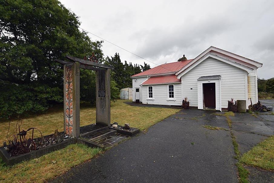
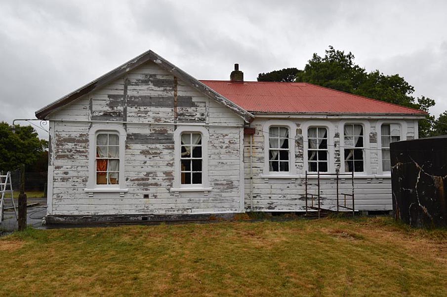
Exterior Kopuāranga is 14 kilometres north of Masterton. Located about three kilometres east of State Highway 2, the area is rural and quiet with relatively few buildings. Kopuāranga School (Former) is the first building approached when entering the settlement from the south and Kopuāranga Hall lies to the northeast of the school. Mature trees surround the former school on two sides. Entry to the grounds is through the 1935 silver jubilee gates, from which the school building is set back by about 20 metres. The school is clad in rusticated timber weatherboards and has a corrugated iron gable roof. The main entrance is on the south-east elevation which faces the road. It consists of the original porch, a smaller porch added in the 1960s, and the lean-to addition of 1897, all of which sit in front of the two classrooms. The north-east elevation is comprised of the 1885 school classroom and the side of the porch with its original double-hung sash window. The classroom wall is dominated by six casement windows on the bottom and six smaller ones above, three of which are louvres. These windows were added in 1959, replacing two original double-hung sash windows. The north-west elevation consists of the rear of the 1885 classroom and the 1897 classroom. The wall of the 1885 classroom has two large original double-hung sash windows and the 1897 classroom has four smaller versions. The south-west elevation of the 1897 classroom wall has no windows, though vertical timber battens indicate the where two windows were once placed. Inside the commemorative gates in front of the building is the free-standing bell tower built to mark the school’s 75th anniversary in 1960, minus the bell, which stored inside the school. A plaque on one of the two upright columns describes its memorial status. The outward facing sides of the two columns are decorated with stones and terracotta figures created by school pupils. The grounds behind the former school contain various outbuildings and structures, including a water tank tower, utility sheds, toilet block and urinal. To the north-east is the tennis court (installed late 1928 ) and school swimming pool (ca. 1956 ) and adjacent to this an old timber flagpole. What may be a shelter shed is located in the playing field near the north-western boundary. Interior The original internal layout appears to be largely intact. The 1885 and 1897 classrooms remain single rooms, though a mezzanine level was been added to the latter room in the 1990s. The building contains original interior features, such as timber floorboards and match-lined timber ceilings. The original brick-lined fireplace between the two classrooms is present but the surround has been removed. The interior architraves on the double-hung sash windows are simply moulded and the head is apex-shaped, in contrast to the curved treatment of the external trims.
Exterior Kopuāranga is 14 kilometres north of Masterton. Located about three kilometres east of State Highway 2, the area is rural and quiet with relatively few buildings. Kopuāranga School (Former) is the first building approached when entering the settlement from the south and Kopuāranga Hall lies to the northeast of the school. Mature trees surround the former school on two sides. Entry to the grounds is through the 1935 silver jubilee gates, from which the school building is set back by about 20 metres. The school is clad in rusticated timber weatherboards and has a corrugated iron gable roof. The main entrance is on the south-east elevation which faces the road. It consists of the original porch, a smaller porch added in the 1960s, and the lean-to addition of 1897, all of which sit in front of the two classrooms. The north-east elevation is comprised of the 1885 school classroom and the side of the porch with its original double-hung sash window. The classroom wall is dominated by six casement windows on the bottom and six smaller ones above, three of which are louvres. These windows were added in 1959, replacing two original double-hung sash windows. The north-west elevation consists of the rear of the 1885 classroom and the 1897 classroom. The wall of the 1885 classroom has two large original double-hung sash windows and the 1897 classroom has four smaller versions. The south-west elevation of the 1897 classroom wall has no windows, though vertical timber battens indicate the where two windows were once placed. Inside the commemorative gates in front of the building is the free-standing bell tower built to mark the school’s 75th anniversary in 1960, minus the bell, which stored inside the school. A plaque on one of the two upright columns describes its memorial status. The outward facing sides of the two columns are decorated with stones and terracotta figures created by school pupils. The grounds behind the former school contain various outbuildings and structures, including a water tank tower, utility sheds, toilet block and urinal. To the north-east is the tennis court (installed late 1928 ) and school swimming pool (ca. 1956 ) and adjacent to this an old timber flagpole. What may be a shelter shed is located in the playing field near the north-western boundary. Interior The original internal layout appears to be largely intact. The 1885 and 1897 classrooms remain single rooms, though a mezzanine level was been added to the latter room in the 1990s. The building contains original interior features, such as timber floorboards and match-lined timber ceilings. The original brick-lined fireplace between the two classrooms is present but the surround has been removed. The interior architraves on the double-hung sash windows are simply moulded and the head is apex-shaped, in contrast to the curved treatment of the external trims.
Historical and Associated Iwi / Hapū / Whānau
Completion Date
18th March 2020
Report Written By
Kerryn Pollock, Vivienne Morrell and Susan Irvine
Information Sources
Fearnley, 1986
C. Fearnley, 'Colonial Style: Pioneer Buildings of New Zealand,' Auckland, 1986
Kopuaranga District Centennial Committee, 1985
Kopuaranga District Centennial Committee, Forest Gateway: Kopuaranga; the place and the people, 1860-1985, 1985
Carlyon, 2014
Carlyon, Robin, ‘Dreyerton/Kopuaranga School’, 2014, https://wairarapaschoolhistory.co.nz/wp-content/uploads/Kopuaranga-Dreyerton-Web-Ready-PDF.pdf
McCallum 1985
McCallum, Angus (ed), Forest Gateway: Kopuaranga, the Place and the People, 1860-1985, incorporating Kopuaranga District Centennial 1885-1985/Country Womans (sic) Institute Golden Jubilee 1935-1985, Masterton, Angus McCallum & Associates, 1985
Petersen, G. C., 1956
Petersen, G.C., Forest Homes: Scandinavian Settlements in New Zealand, Wellington, A.H. & A.W. Reed, 1956
Other Information
Please note that entry on the New Zealand Heritage List/Rārangi Kōrero identifies only the heritage values of the property concerned, and should not be construed as advice on the state of the property, or as a comment of its soundness or safety, including in regard to earthquake risk, safety in the event of fire, or insanitary conditions. Archaeological sites are protected by the Heritage New Zealand Pouhere Taonga Act 2014, regardless of whether they are entered on the New Zealand Heritage List/Rārangi Kōrero or not. Archaeological sites include ‘places associated with pre-1900 human activity, where there may be evidence relating to the history of New Zealand’. This List entry report should not be read as a statement on whether or not the archaeological provisions of the Act apply to the property (s) concerned. Please contact your local Heritage New Zealand office for archaeological advice. A fully referenced New Zealand Heritage List report is available on request from the Central Region Office of Heritage New Zealand.
Current Usages
Uses: Accommodation
Specific Usage: House
Uses: Civic Facilities
Specific Usage: Recreation Reserve/Scenic Reserve
Former Usages
General Usage: Civic Facilities
Specific Usage: Hall, Community
General Usage: Education
Specific Usage: School
Current Usages
Uses: Accommodation
Specific Usage: House
Uses: Civic Facilities
Specific Usage: Recreation Reserve/Scenic Reserve
Former Usages
General Usage: Civic Facilities
Specific Usage: Hall, Community
General Usage: Education
Specific Usage: School
Location
Stay up to date with Heritage this month
