DonateMembershipVisit Heritage
  • Tūrangawaewae
    Places
  • Tira Māori
    Māori Heritage
  • Poutairangahia
    Archaeology
  • Rauemi
    Resources
  • Mō Tātou
    About Us
  • New Zealand Heritage List
  • Nominate and submit
  • Explore the List
  • National Historic Landmarks
  • Plaques
  • Rainbow List Project
  • Lost heritage
  • Visit Heritage
  • Our properties
  • Turnbull House Project
  • Collections
  • Shop
  • Tohu Whenua
  • Tira Māori
  • Conserving Māori heritage
  • Marae built heritage
  • Māori heritage on the List
  • Hinemihi—Te Hokinga Mai
  • What is archaeology?
  • Is there a site on my property?
  • What are my legal requirements?
  • Affecting an archaeological site
  • Declaring an archaeological site
  • Archaeology FAQs
  • Archaeology Digital Library
  • Archaeology guidelines and templates
  • Resources
  • Funding
  • Publications
  • Sustainable management guides
  • Disaster recovery
  • Podcasts & digital resources
  • Education Hub
  • Conservation plans
  • About
  • Board
  • Māori Heritage Council
  • Senior Staff
  • Offices
  • Contact us
  • Careers
  • Covenants
  • Fast-track
  • Corporate documents
  • Currently consulting on
  • Our submissions
  • News
  • Covid-19 response
Quick links
Rārangi Kōrero | The List
Explore the List
National Historic Landmarks
Ngā Manawhenua o Aotearoa me ōna Kōrero Tūturu
Quick links
Tapuwae
A Vision for Places of Māori Heritage
Funding for Māori Heritage
Resources
Quick links
Archaeological Authority Portal
Applying for an archaeological authority
Archaeology FAQs
Browse the most frequently asked questions about archaeological authorities and the archaeological process.
Quick links
Quick links
News
News Keep up to date with Heritage New Zealand Pouhere Taonga
Membership
Membership Find out more and sign up today
  • Places
  • Nominate and submit
  • National Historic Landmarks
  • Places
  • Nominate and submit
  • National Historic Landmarks
  • Tira Māori
  • Conserving Māori heritage
  • Marae built heritage
  • Tira Māori
  • Conserving Māori heritage
  • Marae built heritage
  • Archaeological authorities
  • Archaeology Digital Library
  • Archaeological authorities
  • Archaeology Digital Library
  • All resources
  • Publications
  • Funding
  • All resources
  • Publications
  • Funding
  • FAQs
  • FAQs
Follow us on:
Places
  • Places
  • Nominate and submit
  • National Historic Landmarks
Tira Māori
  • Tira Māori
  • Conserving Māori heritage
  • Marae built heritage
Archaeology
  • Archaeological authorities
  • Archaeology Digital Library
Resources
  • All resources
  • Publications
  • Funding
FAQs
  • FAQs
Follow us on
HomePrivacyTerms and conditionsAbout this site
© Heritage New Zealand Pouhere Taonga 2026.
 
Edith Cavell Bridge

Arthurs Point, QUEENSTOWN

Private

Historic Place Category 1

List No. 4371

Quick links:
List GalleryLocationDetails
The Edith Cavell Bridge, across the upper Shotover River, is a fine example of an early reinforced concrete arch bridge. It was designed to replace an earlier wooden trestle bridge (built in 1875), which in turn had replaced a basic wooden bridge (circa. 1862). A bridge over the Shotover River at this point was necessary to allow the goldminers, who flooded the area after gold was first discovered in 1862, to mine both sides of the river and also to provide access into Skippers Canyon. While bridges are always an important part of a transport network, they were particularly so in and around the Queenstown - Central Otago area, given the nature of the local rivers, swift running and freezing cold. The 1875 bridge remained in situ as support for the concrete boxing while the Edith Cavell Bridge was being constructed. The stone abutments at either end were retained from the 1875 wooden bridge.

Construction began on the Edith Cavell Bridge in 1917. By mid-way through 1918 the Public Works Department reported that 'the main-arch ribs have been completed, and the walings, studs and bracing are well in hand' and it was formally opened in February 1919.
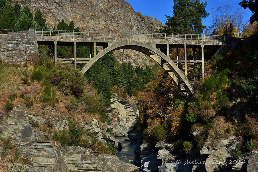
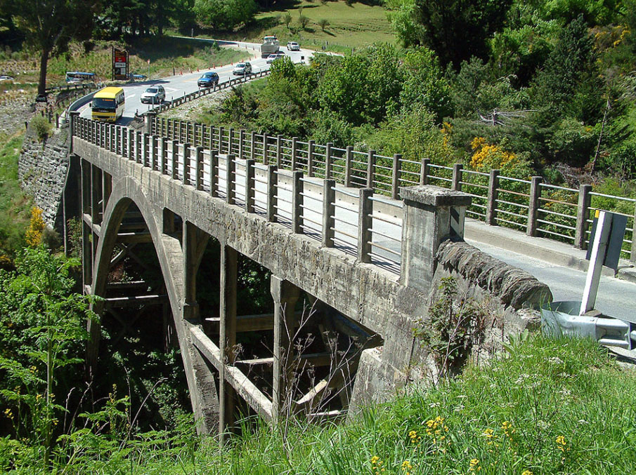
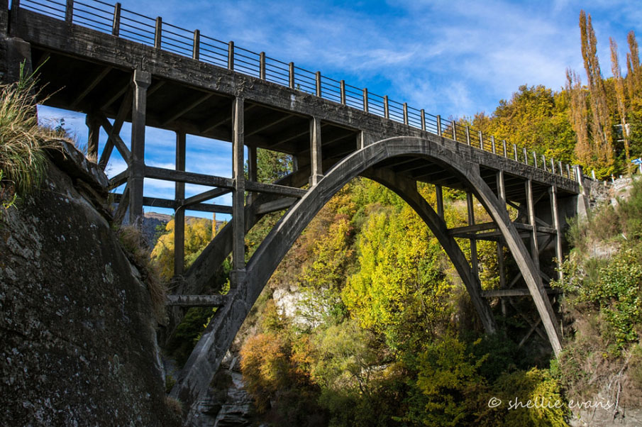
The Edith Cavell Bridge is made from two separate concrete parabolic arches and was only the second reinforced concrete arch bridge to be constructed in New Zealand. (The first being Grafton Bridge (1910) in Auckland, also registered by the New Zealand Historic Places Trust/Pouhere Taonga.) Although much smaller than the Grafton Bridge, the two share some features. It is thought that the designer of the Edith Cavell Bridge, Frederick William Furkert (1876-1949), was inspired by both Grafton Bridge and his recent travels overseas. Furkert, who, at the time, was the Public Works Department's Inspecting Engineer and went on to become Engineer-in-Chief (and thus permanent head of the department), is described by expert on engineering heritage Geoffrey Thornton as a 'brilliant all-round engineer' and the Edith Cavell Bridge is a significant example of his work. As with the Grafton Bridge the deck of the Edith Cavell Bridge is supported on vertical struts which rise from the arches. The deck is 27.4 metres above the river and is single-lane. The structure of the bridge is unusual in the way in which the vertical struts are tied horizontally (unlike Grafton) and are braced transversely at either end by diagonal members.

It is said that the bridge became known as the Edith Cavell Bridge because of the efforts of a local goldminer, Jack Clark. Clark lived in a sod hut near the bridge and was an admirer of Edith Cavell, the British nurse shot by the Germans in World War I for assisting British soldiers in Belgium. He painted a sign, 'To Cavell Bridge', in red letters on a nearby rock face and asked the local council that the bridge be named after her. When his request was denied he painted the name on the side of the bridge and although the lettering eventually faded, the name 'Edith Cavell' passed into common usage, thus establishing an unofficial World War I memorial.

The Edith Cavell Bridge is technologically significant as the second reinforced concrete two-pin parabolic arch bridge to be built in New Zealand and the first in the South Island. Elegant and light in appearance, it is unusual in design and was conceived by one of the Public Works Department's noted engineers. Its name stands as both a memorial to Edith Cavell, and to the determination of Jack Clark to honour her sacrifice. The bridge is now commonly associated with the district's adventure tourism industry as jetboats, which carry visitors along the Shotover, leave from just upstream of the bridge.
Edith Cavell Bridge, Arthurs Point. Image courtesy of www.flickr.com | Shellie Evans - flyingkiwigirl | 03/05/2014 | Shellie Evans
Edith Cavell Bridge, Arthurs Point. CC Licence 3.0. Image courtesy of commons.wikimedia.org | Andre Richard Chalmers - Wikimedia Commons | 02/11/2012 | Andre Richard Chalmers
Edith Cavell Bridge, Arthurs Point. Image courtesy of www.flickr.com | Shellie Evans – flyingkiwigirl | 21/04/2016 | Shellie Evans

List Entry Information

Overview

Status
Listed

List Entry Status
Historic Place Category 1

Access
Private/No Public Access

List Number
4371

Date Entered
26th November 1987

Date of Effect
26th November 1987

City/District Council
Queenstown-Lakes District

Region
Otago Region

Legal description

Bridge adjoining Crown Land being the banks of the Shotover River.

Location Description

The Edith Cavell Bridge is located on the road which runs between Queenstown and Arrowtown.

Detailed List Entry

Construction Professional

Name

Furkert, Frederick William.

Type

Engineer

Biography

http://www.dnzb.govt.nz/dnzb/ - search for Furkert.

Construction Details

Start Year

1917

Finish Year

1919

Type

Original Construction

Reference

Completion Date

1st July 2002

Report Written By

Melanie Lovell-Smith

Information Sources

Appendices to the Journals of the House of Representatives (AJHR)

Appendices to the Journals of the House of Representatives

Dictionary of New Zealand Biography

Dictionary of New Zealand Biography

MacLean, 1990

Chris MacLean and Jock Phillips, The Sorrow and the Pride: New Zealand War Memorials, Wellington, 1990

Thornton, 2001

Geoffrey Thornton, Bridging the Gap, Early Bridges in New Zealand 1830-1939, Auckland, 2001

Thornton, 1996

Geoffrey Thornton, Cast in Concrete: Concrete Construction in New Zealand 1850-1939, Auckland, 1996

Report Written By

This place was identified as significant under previous legislation with different information requirements. It remains significant under the current legislation. There is opportunity under our legislation and policies to add to this information. Further information about this place may be available from the Otago/Southland Office of Heritage New Zealand Pouhere Taonga. Please note that entry on the New Zealand Heritage List/Rarangi Korero identifies only the heritage values of the property concerned, and should not be construed as advice on the state of the property, or as a comment of its soundness or safety, including in regard to earthquake risk, safety in the event of fire, or insanitary conditions.

Further Information

Current Usages

Uses: Transport

Specific Usage: Bridge/ Viaduct

Former Usages

General Usage:: Transport

Specific Usage: Bridge/ Viaduct

Themes

Web Links

Overview

Status

Listed

List Entry Status

Historic Place Category 1

Access

Private/No Public Access

List Number

4371

Date Entered

26th November 1987

Date of Effect

26th November 1987

City/District Council

Queenstown-Lakes District

Region

Otago Region

Legal description

Bridge adjoining Crown Land being the banks of the Shotover River.

Location Description

The Edith Cavell Bridge is located on the road which runs between Queenstown and Arrowtown.

Construction Information

Construction Professional

Name

Furkert, Frederick William.

Type

Engineer

Biography

http://www.dnzb.govt.nz/dnzb/ - search for Furkert.

Construction Details

Start Year

1917

Finish Year

1919

Type

Original Construction

Construction Professional

Name

Furkert, Frederick William.

Type

Engineer

Biography

http://www.dnzb.govt.nz/dnzb/ - search for Furkert.

Construction Details

Start Year

1917

Finish Year

1919

Type

Original Construction

Reference

Historical and Associated Iwi / Hapū / Whānau

Completion Date

1st July 2002

Report Written By

Melanie Lovell-Smith

Information Sources

Appendices to the Journals of the House of Representatives (AJHR)

Appendices to the Journals of the House of Representatives

Dictionary of New Zealand Biography

Dictionary of New Zealand Biography

MacLean, 1990

Chris MacLean and Jock Phillips, The Sorrow and the Pride: New Zealand War Memorials, Wellington, 1990

Thornton, 2001

Geoffrey Thornton, Bridging the Gap, Early Bridges in New Zealand 1830-1939, Auckland, 2001

Thornton, 1996

Geoffrey Thornton, Cast in Concrete: Concrete Construction in New Zealand 1850-1939, Auckland, 1996

Other Information

This place was identified as significant under previous legislation with different information requirements. It remains significant under the current legislation. There is opportunity under our legislation and policies to add to this information. Further information about this place may be available from the Otago/Southland Office of Heritage New Zealand Pouhere Taonga. Please note that entry on the New Zealand Heritage List/Rarangi Korero identifies only the heritage values of the property concerned, and should not be construed as advice on the state of the property, or as a comment of its soundness or safety, including in regard to earthquake risk, safety in the event of fire, or insanitary conditions.

Further Information

Current Usages

Uses: Transport

Specific Usage: Bridge/ Viaduct

Former Usages

General Usage: Transport

Specific Usage: Bridge/ Viaduct

Current Usages

Uses: Transport

Specific Usage: Bridge/ Viaduct

Former Usages

General Usage: Transport

Specific Usage: Bridge/ Viaduct

Location

Loading
Stay up to date with Heritage this month