

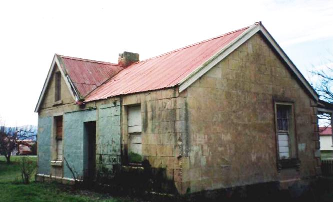
William Dansey was established on Otekaike by May 1858. William Henry Dansey, the youngest son of a scholarly rector, was educated at Exeter College, Oxford. He arrived in Port Chalmers in December 1854 and after visiting Port Nicholson and Nelson, made his way to the Waitaki Valley. Dansey had a house on Run 28 by early 1859, as he is reported as an elector in the Waitaki District in April of that year. A survey plan from April 1861 Dansey’s freehold: a 92 acre block with his house, stable and futtah, and an adjacent 11 acre block with ‘men’s house’ and woolshed.’ Dansey laid the foundation for the next runholder – Robert Campbell – who would make the property one of the most significant in New Zealand.
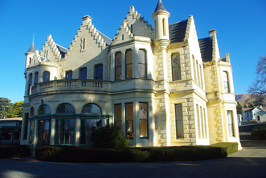
Robert Campbell, the Eton-educated son of a wealthy gentleman, bought the property in March 1865. Campbell owned Galloway Station in Central Otago, Benmore Station near Omarama, and three Southland runs. He built up a grand estate with his gentleman’s residence in Scottish Baronial style, the crowning jewel. The stable (the earlier stable was also used, but was later demolished) was probably built at the same time as the residence, as such a building was essential to the operation of the property. Horses provided the motive power for transport, cultivation and haulage.
For all his wealth and privilege life did not go well for Campbell. Family scandals and heavy drinking took its toll on his performance and reputation. Campbell’s involvement at Otekaike declined. The property was transferred to a family holding company (Robert Campbell & Sons Ltd), the seventh-largest corporate landholder in New Zealand in 1882. Robert Campbell died in 1889 and his wife a year later. Otekaike Station leases were due to expire in 1911 but the Company surrendered them early and the station was broken up for closer settlement in 1908, after considerable public pressure.
The Otekaike Station was subdivided into seven small grazing runs, thirty seven farms and twelve smallholdings, the largest ballot for settlement sections held in North Otago. Four properties were allocated as ‘preferential blocks’ and allocated to former employees of Robert Campbell and Sons Limited, though this caused vocal protests. The grand homestead, stables and other buildings along with 342 acres of land was handed over the Education Department as a Otekaike Special School for Boys. The school was a national institution providing for special education of developmentally delayed (‘feeble minded as initially labelled) boys. In 1925 it moved to the jurisdiction of the Child Welfare Division. It was renamed Campbell Park School in 1964. When the school was closed in 1995, the property was sold.
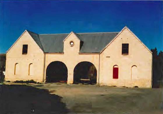
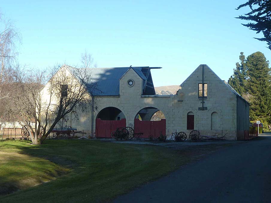
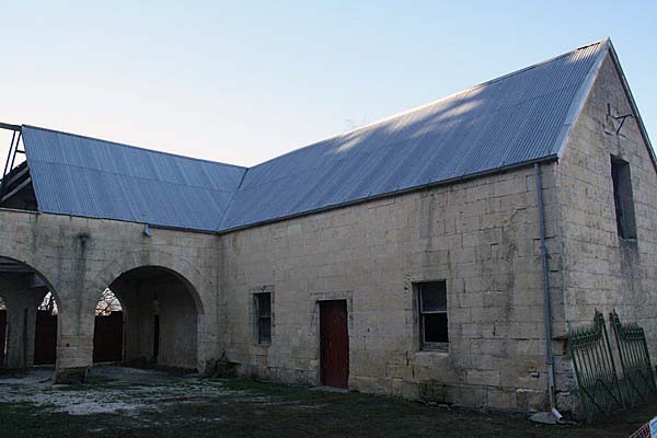
The Campbell Park Stable is built of stone and has a corrugated iron roof. It is set out in a U-shape, square in plan. The two main wings are parallel and separated by a yard. The connection between the wings is at the north. Two arches provide access to the courtyard from the driveway. Originally there was a chimney at each north gable end but these have been removed. In recent years there has been storm damage to the roof. In 2016, the stable remains a key element in the historic Campbell Park Estate.
List Entry Information
Status
Listed
List Entry Status
Historic Place Category 1
Access
Private/No Public Access
List Number
4377
Date Entered
26th November 1987
Date of Effect
26th November 1987
City/District Council
Waitaki District
Region
Canterbury Region
Extent of List Entry
Extent includes part of the land described as Lot 1 DP 465971 (RT 621856), Otago Land District, and the structure known as Campbell Park Stables (Former), thereon, as shown in the extent map tabled at the Rarangi Korero Committee meeting on 9 March 2017.
Legal description
Lot 1 DP 465971 (RT 621856), Otago Land District
Why is this place significant?
Historic Significance
Historical Significance or Value Robert Campbell (1843-89) was a major sheep baron of North Otago and a member of the Legislative Council from 1870. Born at Buscot, educated at Eton, he came to New Zealand in 1866 to buy up land on behalf of his family firm, Robert Campbell and Sons. By the 1870s the firm owned properties running 300,000 sheep and including Galloway, Benmore and Otekaieke, Campbell imported 100 ewes from a Rambouillet Merino stud in 1863, and the station archives also show he bought a bull for 100 pounds, making him an important improver of stock quality in the area. He took up residence in his baronial style house at Otekaieke in 1876. As well as his parliamentary duties, he was chairman of the Waitaki County Council for some years and a member of the Otago University Senate 1871-79. He was not a creative legislator and was critical of the efforts of the Otago Provincial Council's attempts to take better class land out of run tenure for free holding. Evidence put before a parliamentary committee in 1885 showed that his firm had deliberately evaded the provisions of the act dealing with land aggregation, and after this he took little part in public affairs until his death in 1889.
Physical Significance
ARCHITECTURAL SIGNIFICANCE: A grand stable in the tradition of the great houses of British. The stables would have been essential to the social and business life of Robert Campbell and his family and were probably built at the same time or even before the homestead. Though the building is said to be like the stables at Buscot, England, the latter were plainer and Georgian in design with larger windows and a central ventilation tower. TOWNSCAPE/LANDMARK SIGNIFICANCE: A major rural farmstead in North Otago, associated with a very large house.
Construction Professional
Name
Wales, Nathaniel Young Armstrong
Type
Architect
Biography
Wales was born in Northumberland, England, and educated at Jedburgh, Scotland. He immigrated to Australia in 1854 and found employment as a carpenter working on the buildings for the first exhibition held in Melbourne. He arrived in Dunedin about 1863, and was a clerk of works for William Mason on the old Bank of New Zealand Building (1862-64), the Post Office Building (1864-68) and the Port Chalmers Graving Dock (1868-72). Wales entered partnership with William Mason in 1871. The firm of Mason and Wales was responsible for many fine buildings in Dunedin including Bishopscourt (1873), St Matthew's Church (1873), Government Life Insurance Building (1897) and Wains Hotel (1878). Wales had military and political interests and was a Member of Parliament for some years. He occupied a seat on the Dunedin Harbour Board and was a Dunedin City Councillor. In 1895 he was elected Mayor of Dunedin. In 1900 he was elected a Fellow of the Royal Institute of British Architects. Nathaniel Wales worked for William Mason as a clerk of works during the 1860s on the old Bank of New Zealand building and on the Post Office building which became the Stock Exchange. He also had the thankless task of being clerk of works to the Port Chalmers Dry dock. Wales began work on his own as an architect untrained, and asked Mason to come back from retirement to enable him to join his firm which became Mason and Wales in 1871 at a time when Wales was building the first part of the Iona Union church at Port Chalmers. Mason retied for good in 1874 and Wales became the senior partner in the firm. Wales designed the Campbell Park Homestead in 1876 and received the commission for the stables about 1878, along with some cottages for the farm labourers. One of his notable buildings is his own big house at 38 Belgrave Crescent (1870), built of stone quarried from the site.
Construction Details
Start Year
1876
startYearCirca
Type
Original Construction
Construction Materials
Oamaru stone walls and foundations, with a corrugated iron roof which appears to be relatively recent. The building consists of two wings connected by an archway and loft. There is a cobbled area under the open central archway which once had gates on one side. Original windows were six-paned, suggesting an early date of construction. The stable area has half doors and seems to have largely dirt floors.
Notable Features
Its size and grand styling.
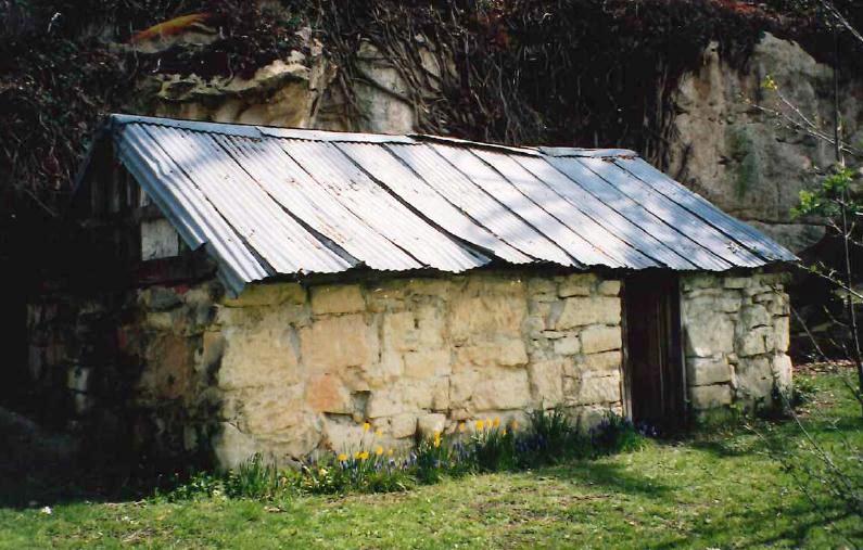
In September 1853, Samuel Pike was the first to apply for Run 28. He was granted a 14 year lease from 11 September 1854. The original boundaries of the run were from Kurow and Otekaike Creeks back to the summit of the Saint Mary Range. Samuel Pike owned several runs in the lower Waitaki on the Canterbury side of the river. By 1855, Pike had transferred the run to John Parkin Taylor (1812-1875), the later superintendent of Southland, and Taylor transferred the run to William Dansey. William Dansey was established on Otekaike by May 1858. William Henry Dansey, the youngest son of a scholarly rector, was educated at Exeter College, Oxford. He arrived in Port Chalmers in December 1854 and after visiting Port Nicholson and Nelson, made his way to the Waitaki Valley. Dansey had a house on Run 28 by early 1859, as he is reported as an elector in the Waitaki District in April of that year. A survey plan from April 1861 shows the Crown grant to William Dansey within Run 28 – a 92 acre block with his house, stable and futtah, and an adjacent 11 acre block with ‘men’s house’ and woolshed.’ Dansey laid the foundation for the next runholder who would make the property one of the most significant in New Zealand. After a high profile court case involving dubious transactions over the ownership of sheep, Cargill and Co. sold the station under bill of sale. In March 1865 Dansey’s pre-emptive rights were sold by the mortgagee. The advertisement in the Otago Daily Times described the properties: 92 acres with stone house, separate servants’ quarters, stone stable, carriage house, gardener’s cottage, two acres of garden, store, stockyards and next door a further 11 acres pre-emptive right with ‘a large well-built men’s stone HUT, with good dairy and coal-sheds’ and a ‘WEATHERBOARD WOOL-SHED, about 45 x 40 feet, with iron roof, and yards to work 10,000 sheep.’ Dansey moved to Oamaru where he became and auditor and later collector for the Oamaru Borough (as position from which he was later dismissed) before trying his hand at runholding again in 1893, at Minaret station, where once again he had to surrender the lease. He died in Kaponga in Taranaki in May 1909. Robert Campbell, the Eton-educated son of a wealthy gentleman, bought the property in March 1865. Campbell owned Galloway Station in Central Otago, Benmore Station near Omarama, and three Southland runs. He was Oamaru’s member of the House of Representatives, though unpopular with his constituent and he resigned on his marriage. Campbell deemed the homestead too small and sent his new wife back to his English home and set about building an appropriately grand mansion, what has become known as Campbell Park Homestead. A newspaper report from 1876 indicates that an earlier residence was demolished to make way for the mansion. The earlier house was described as ‘without exception, the finest in Otago.’ Campbell employed managers to look after the daily running of the station. W.H. Ostler was probably the first manager. He was replaced by William Gilbert Rees at the end of 1868. Rees is a significant figure in Otago’s pastoral history, being a partner of a huge station near what would become Queenstown, a large part of which was declared a Goldfield, to Rees’ disadvantage. Rees became a manager, first at Otekaike and then across the Waitaki River at Station Peak. Malcolm McKellar became manager at Otekaike in 1871. The stations were part of an extended network, sharing tradesmen, knowledge and orders. An article in the Otago Daily Times describes Campbell’s residence. The foundation stone was laid in May 1876 of what would be ‘one of the best country houses in New Zealand.’ The house was of ‘Scotch Baronial style, with battlemented gables and turreted angles. The stone was quarried from a nearby limestone outcrop, the roof clad in Otepopo slates. The detail is worth noting: ‘The principal entrance is from a spacious portico of segmental form, with columns and arches springing from the angles of two large bay windows….The hall measures 20ft. x 17ft. [6 by 5.2m], and at the farther end of which, and separated from it by and archway, with columns on either side, is the staircase, 7ft. x 14ft. [2.1 by 4.2m] Opening from these are the drawing room and library, each 20ft. x 25ft [6 by 7.6m], with two large bays in each; and the dining-room, bath room, and office, en suite, to which there is a porch and side entrance.’ A serving room adjoined the dining-room with a passage to the kitchen. Behind the staircase was a strong room and a servants’ stair. The kitchen was 22 ft. by 17 ft [6.7 by 5.2m], with a large laundry, scullery and offices. Upstairs was a landing with a lantern light above. From the landing there were seven large bedrooms, four with dressing rooms, with bathrooms and other conveniences. Three servants’ bedrooms were on this floor too. There was an underground concrete cistern for storing roof water. The grounds were laid out and planted with evergreen and deciduous trees. The stone stables look to have been built at the same time as the house. The Otekaike Estate was the focal point of the region – economically and socially. The North Otago Times reported a pre-Christmas visit in 1877 describing Campbell’s grand residence and stables, but also mentioning the more modest structures at the Estate: ‘the comfortable stone residence of the station manager, Mr McKellar, close by which is a pool containing some monster trout; the cook-house and bakehouse for the hands, of whom there are now 70 to be housed and fed; and the store and the shearing-sheds, just now the busiest of busy scenes. ‘ For all his wealth and privilege life did not go well for Campbell. Family scandals and heavy drinking took their toll on his performance and reputation. Campbell’s involvement at Otekaike declined. The property was transferred to a family holding company (Robert Campbell & Sons Ltd), the seventh-largest corporate landholder in New Zealand in 1882. Robert Campbell died in 1889 and his wife a year later. Otekaike Station leases were due to expire in 1911 but the Company surrendered them early and the station was broken up for closer settlement in 1908, after considerable public pressure. The Otekaike Station was subdivided into seven small grazing runs, thirty seven farms and twelve smallholdings, the largest ballot for settlement sections held in North Otago. Four properties were allocated as ‘preferential blocks’ and allocated to former employees of Robert Campbell and Sons Limited, though this caused vocal protests. Dickson (Dick) Jardine (the Company’s manager) was granted the homestead block – with the ‘large stone house, woolshed, scouring shed, blacksmith’s shop, men’s hut, cook house, two small cottages and a slaughter house. The grand homestead, stables and other buildings along with 342 acres of land was handed over the Education Department as a special school for boys. The Otekaike Special School for Boys was initially housed in the grand homestead, but a need for more space meant the school’s facilities were extended – many new structures were built, including the principal’s residence (1912), cottages, a laundry and kitchen block, classroom blocks, houses for staff. The trees around the estate were felled to allow for the expansion of facilities. In the 1960s the name of the school was changed to Campbell Park School. This heralded a programme of rebuilding and demolition of some of the older structures on site, including the old day school. The grand homestead was declared unsafe and closed in 1972 and plans made for its demolition. Local opposition saw the building saved. Campbell Park School closed in 1987 and the property was sold into private ownership. In 2016 the extensive Campbell Park Complex is privately owned.
In September 1853, Samuel Pike was the first to apply for Run 28. He was granted a 14 year lease from 11 September 1854. The original boundaries of the run were from Kurow and Otekaike Creeks back to the summit of the Saint Mary Range. Samuel Pike owned several runs in the lower Waitaki on the Canterbury side of the river. By 1855, Pike had transferred the run to John Parkin Taylor (1812-1875), the later superintendent of Southland, and Taylor transferred the run to William Dansey. William Dansey was established on Otekaike by May 1858. William Henry Dansey, the youngest son of a scholarly rector, was educated at Exeter College, Oxford. He arrived in Port Chalmers in December 1854 and after visiting Port Nicholson and Nelson, made his way to the Waitaki Valley. Dansey had a house on Run 28 by early 1859, as he is reported as an elector in the Waitaki District in April of that year. A survey plan from April 1861 shows the Crown grant to William Dansey within Run 28 – a 92 acre block with his house, stable and futtah, and an adjacent 11 acre block with ‘men’s house’ and woolshed.’ Dansey laid the foundation for the next runholder who would make the property one of the most significant in New Zealand. After a high profile court case involving dubious transactions over the ownership of sheep, Cargill and Co. sold the station under bill of sale. In March 1865 Dansey’s pre-emptive rights were sold by the mortgagee. The advertisement in the Otago Daily Times described the properties: 92 acres with stone house, separate servants’ quarters, stone stable, carriage house, gardener’s cottage, two acres of garden, store, stockyards and next door a further 11 acres pre-emptive right with ‘a large well-built men’s stone HUT, with good dairy and coal-sheds’ and a ‘WEATHERBOARD WOOL-SHED, about 45 x 40 feet, with iron roof, and yards to work 10,000 sheep.’ Dansey moved to Oamaru where he became and auditor and later collector for the Oamaru Borough (as position from which he was later dismissed) before trying his hand at runholding again in 1893, at Minaret station, where once again he had to surrender the lease. He died in Kaponga in Taranaki in May 1909. Robert Campbell, the Eton-educated son of a wealthy gentleman, bought the property in March 1865. Campbell owned Galloway Station in Central Otago, Benmore Station near Omarama, and three Southland runs. He was Oamaru’s member of the House of Representatives, though unpopular with his constituent and he resigned on his marriage. Campbell deemed the homestead too small and sent his new wife back to his English home and set about building an appropriately grand mansion, what has become known as Campbell Park Homestead. A newspaper report from 1876 indicates that an earlier residence was demolished to make way for the mansion. The earlier house was described as ‘without exception, the finest in Otago.’ Campbell employed managers to look after the daily running of the station. W.H. Ostler was probably the first manager. He was replaced by William Gilbert Rees at the end of 1868. Rees is a significant figure in Otago’s pastoral history, being a partner of a huge station near what would become Queenstown, a large part of which was declared a Goldfield, to Rees’ disadvantage. Rees became a manager, first at Otekaike and then across the Waitaki River at Station Peak. Malcolm McKellar became manager at Otekaike in 1871. The stations were part of an extended network, sharing tradesmen, knowledge and orders. An article in the Otago Daily Times describes Campbell’s residence. The foundation stone was laid in May 1876 of what would be ‘one of the best country houses in New Zealand.’ The house was of ‘Scotch Baronial style, with battlemented gables and turreted angles. The stone was quarried from a nearby limestone outcrop, the roof clad in Otepopo slates. The detail is worth noting: ‘The principal entrance is from a spacious portico of segmental form, with columns and arches springing from the angles of two large bay windows….The hall measures 20ft. x 17ft. [6 by 5.2m], and at the farther end of which, and separated from it by and archway, with columns on either side, is the staircase, 7ft. x 14ft. [2.1 by 4.2m] Opening from these are the drawing room and library, each 20ft. x 25ft [6 by 7.6m], with two large bays in each; and the dining-room, bath room, and office, en suite, to which there is a porch and side entrance.’ A serving room adjoined the dining-room with a passage to the kitchen. Behind the staircase was a strong room and a servants’ stair. The kitchen was 22 ft. by 17 ft [6.7 by 5.2m], with a large laundry, scullery and offices. Upstairs was a landing with a lantern light above. From the landing there were seven large bedrooms, four with dressing rooms, with bathrooms and other conveniences. Three servants’ bedrooms were on this floor too. There was an underground concrete cistern for storing roof water. The grounds were laid out and planted with evergreen and deciduous trees. The stone stables look to have been built at the same time as the house. The Otekaike Estate was the focal point of the region – economically and socially. The North Otago Times reported a pre-Christmas visit in 1877 describing Campbell’s grand residence and stables, but also mentioning the more modest structures at the Estate: ‘the comfortable stone residence of the station manager, Mr McKellar, close by which is a pool containing some monster trout; the cook-house and bakehouse for the hands, of whom there are now 70 to be housed and fed; and the store and the shearing-sheds, just now the busiest of busy scenes. ‘ For all his wealth and privilege life did not go well for Campbell. Family scandals and heavy drinking took their toll on his performance and reputation. Campbell’s involvement at Otekaike declined. The property was transferred to a family holding company (Robert Campbell & Sons Ltd), the seventh-largest corporate landholder in New Zealand in 1882. Robert Campbell died in 1889 and his wife a year later. Otekaike Station leases were due to expire in 1911 but the Company surrendered them early and the station was broken up for closer settlement in 1908, after considerable public pressure. The Otekaike Station was subdivided into seven small grazing runs, thirty seven farms and twelve smallholdings, the largest ballot for settlement sections held in North Otago. Four properties were allocated as ‘preferential blocks’ and allocated to former employees of Robert Campbell and Sons Limited, though this caused vocal protests. Dickson (Dick) Jardine (the Company’s manager) was granted the homestead block – with the ‘large stone house, woolshed, scouring shed, blacksmith’s shop, men’s hut, cook house, two small cottages and a slaughter house. The grand homestead, stables and other buildings along with 342 acres of land was handed over the Education Department as a special school for boys. The Otekaike Special School for Boys was initially housed in the grand homestead, but a need for more space meant the school’s facilities were extended – many new structures were built, including the principal’s residence (1912), cottages, a laundry and kitchen block, classroom blocks, houses for staff. The trees around the estate were felled to allow for the expansion of facilities. In the 1960s the name of the school was changed to Campbell Park School. This heralded a programme of rebuilding and demolition of some of the older structures on site, including the old day school. The grand homestead was declared unsafe and closed in 1972 and plans made for its demolition. Local opposition saw the building saved. Campbell Park School closed in 1987 and the property was sold into private ownership. In 2016 the extensive Campbell Park Complex is privately owned.
ARCHITECTURAL DESCRIPTION (Style): A utilitarian building of simple barn shaped profile but with some classical detailing, such as the arched window heads and quoined wall corners. The round hole in the centre gable may have been designed to hold a clock like the stable at Buscot, Scotland. MODIFICATIONS: Exterior unmodified. Interior in disrepair, with rotten stairway and flooring.
ARCHITECTURAL DESCRIPTION (Style): A utilitarian building of simple barn shaped profile but with some classical detailing, such as the arched window heads and quoined wall corners. The round hole in the centre gable may have been designed to hold a clock like the stable at Buscot, Scotland. MODIFICATIONS: Exterior unmodified. Interior in disrepair, with rotten stairway and flooring.
Historical and Associated Iwi / Hapū / Whānau
Public NZAA Number
I40/65
Completion Date
14th December 2016
Report Written By
Heather Bauchop
Information Sources
Dictionary of New Zealand Biography
Dictionary of New Zealand Biography
McDonald, 1962
K C McDonald, 'White Stone Country', Oamaru, 1962
McLay, 1985
Gwennyth McLay 1985. N Y A Wales- Architect.
McLintock, 1966
An Encyclopedia of New Zealand, Government Printer, Wellington, 1966
New Zealand Journal of History
New Zealand Journal of History
Pinney, 1981
R. Pinney, Early Northern Otago Runs, Auckland, 1981
Thornton, 1986
Geoffrey Thornton, The New Zealand Heritage of Farm Buildings, Auckland, 1986
Porter, 1983
Frances Porter (ed), Historic Buildings of Dunedin, South Island, Methuen, Auckland, 1983.
Petchey, 2003
Peter Petchey, ‘Campbell Park Heritage Assessment: History and archaeology of Otekaieke Estate, grounds and gardens’, 2003
Other Information
This historic place was registered under the Historic Places Act 1980. This report includes the text from the original Building Classification Committee report considered by the NZHPT Board at the time of registration. Please note that entry on the New Zealand Heritage List/Rarangi Korero identifies only the heritage values of the property concerned, and should not be construed as advice on the state of the property, or as a comment of its soundness or safety, including in regard to earthquake risk, safety in the event of fire, or insanitary conditions. A fully referenced upgrade report is available on request from the Otago/Southland Area Office of Heritage New Zealand.
Former Usages
General Usage: Agriculture
Specific Usage: Stables
Web Links
description: Campbell Park Estate
url: http://www.campbellpark.org/Campbell%20Park%2008/Home.html
Former Usages
General Usage: Agriculture
Specific Usage: Stables
Web Links
description: Campbell Park Estate
url: http://www.campbellpark.org/Campbell%20Park%2008/Home.html
Location
Sign up to hear more
Get the latest heritage news, features and events delivered
straight to your inbox.
