

The property occupied by Belgrave was initially part of an endowment reserved by Governor George Grey under the Grammar School Trust Deed of 1850. In the 1860s, timber structures were erected on the site by lessees, John McRae and James Allen, respectively a settler and journalist. As property values rose, the Auckland College and Grammar School Trust sought to improve its income by demolishing existing structures and creating new subdivisions, specifying that dwellings on each property should cost no less than ₤500. In 1884 Alexander Campbell, a merchant draper, leased the subdivision occupied by Belgrave, erecting a new, elegant dwelling the following year. This appears to have been built for rental purposes as Campbell himself lived in nearby Domain Street.
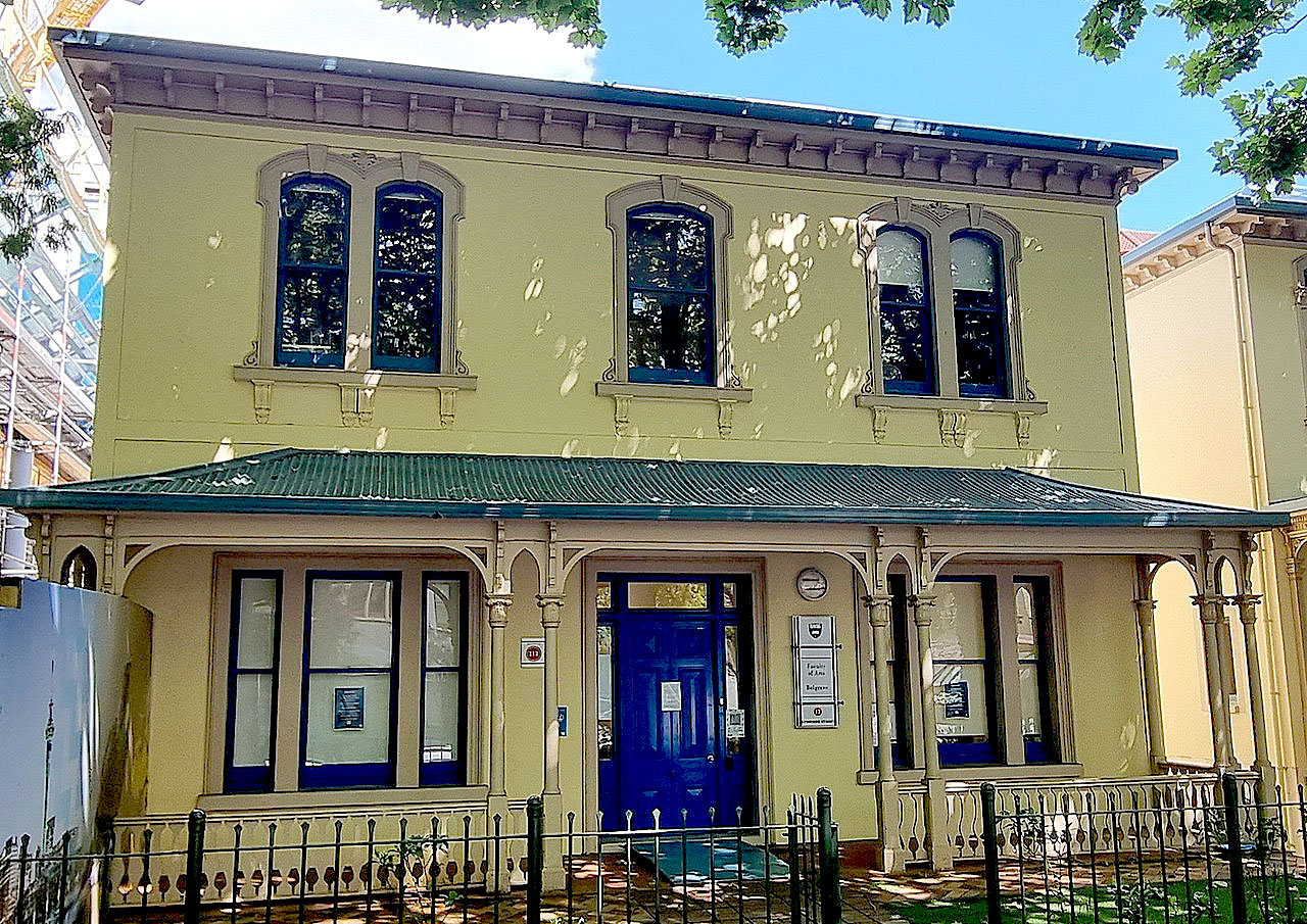
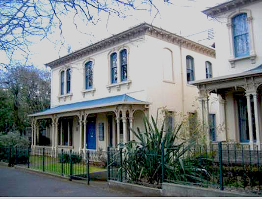
Belgrave was constructed in an ornate Italianate design that was fashionable in the 1870s and 1880s, particularly among merchants, whose commercial premises were often built in a similar style. Its frontage was symmetrical, unlike its two neighbours that were erected to the south at a similar time. Befitting its financial value, Belgrave was built of durable materials, incorporating lime or cement scoria walls and a slate roof. Comparatively few concrete structures had previously been erected in the colonial centre of Auckland, although nearby buildings in Princes Street and Bankside Street were also erected of this material in the mid 1880s. Built on sloping ground, the building contained two main storeys for reception rooms and bedrooms, with a kitchen and service rooms probably located in its basement. A rear verandah looked out over a large back garden, and offered more distant views across Grafton Gully to the Auckland Domain.
Although apparently designed as a large family residence, Belgrave was completed just as the urban property market collapsed. Its first occupant was Mrs Andrew Craig, the widow of a plumber, who may have employed the property as a boarding house from the outset. This form of use became increasingly popular for large inner city dwellings during the depression of the late 1880s and 1890s, when many wealthier residents moved to suburban locations. In the 1920s, the building was known as Montrosa, subsequently evolving into an apartment house containing 23 apartments or bed sitting rooms, some of which were contained in a rear annex. Following its acquisition by the University of Auckland in the 1960s, the building housed the Town Planning Department, then the Political Studies Department, its current occupants. Its rear garden was removed by the early 1980s, when a large Arts Building was erected. Alterations were carried out to the main house at a similar time, including the removal of the later annex and other elements, particularly in the eastern part of the structure.
Belgrave is aesthetically significant as one of a cluster of three imposing and ornate Italianate villas, enhanced by its tree-lined frontage to Symonds Street. It is architecturally significant as a surviving example of a two-storey colonial dwelling of urban design, evidently built to house citizens of standing. The place has historical value for its association with the conversion of the Symonds Street ridge into a desirable residential district following the departure of the colonial capital to Wellington. It is of technological value for its concrete construction, potentially showing evidence of specialised building techniques and materials from a period when such construction was uncommon.
List Entry Information
Status
Listed
List Entry Status
Historic Place Category 2
Access
Private/No Public Access
List Number
4488
Date Entered
22nd June 2007
Date of Effect
22nd June 2007
City/District Council
Auckland Council
Region
Auckland Council
Extent of List Entry
Registration includes the land in NZ Gazette 1992, p.2388 (as shown on the 'Extent of Registration' plan in Appendix 3 of the Registration Report), and the structures, their fittings and fixtures thereon, excluding the Arts Building to the southeast and its footprint. The registration includes garden features such as walls, railings and a gate in the northwestern part of the property.
Legal description
Allot 35 Sec 9 City of Auckland (NZ Gazette 1992, p.2388), North Auckland Land District
Why is this place significant?
Historic Significance
Historical Significance or Value The place has historical significance for its association with the transformation of the Symonds Street ridge into a sought-after residential district following the transfer of the colonial capital to Wellington. It demonstrates the role of the area as a high status enclave within the later colonial town and also reflects subsequent changes to the area, including the conversion of many large inner city dwellings to boarding houses and the subsequent development of the area for university purposes.
Physical Significance
Aesthetic Significance or Value Belgrave has aesthetic significance as one of a cluster of three imposing and ornate late-Victorian urban villas designed in the Italianate style. Its aesthetic value is enhanced by the collective similarity of design, scale and detailing of these buildings, and their proximity to the tree-lined frontage of Symonds Street. Collectively the group enhances the visual amenity of lower Symonds Street, one of Auckland's earliest colonial thoroughfares. Architectural Significance or Value Belgrave has architectural significance as a surviving example of a two-storey colonial dwelling of urban design, evidently built to house citizens of standing. Its architectural significance is enhanced by the survival of two adjoining villas, which demonstrate the spatial relationship of many large villas to each other within a late colonial urban environment. Technological Significance or Value The building has technological significance for its early concrete construction, potentially showing evidence of specialised building techniques and materials from a period when such construction was uncommon.
Why is this place Category 1 / Category 2?
Detail Of Assessed Criteria
(a) The extent to which the place reflects important or representative aspects of New Zealand history Belgrave reflects the evolution of Auckland's lower Symonds Street area as a sought-after residential address in the latter decades of the nineteenth century. Together with two other dwellings to the southwest, it demonstrates the nature of the urban streetscape in a well-to-do part of the colonial city. It also reflects the adaptation and use of large dwellings in the twentieth century as boarding houses and flats, and for office accommodation for academics in the expanding tertiary education sector. (c) The potential of the place to provide knowledge of New Zealand history The place has potential to provide information about the development of concrete construction in New Zealand, being an early surviving example in the Auckland region. (f) The potential of the place for public education Located beside a busy Auckland thoroughfare and as part of a major tertiary institution, Belgrave has potential for public education about the history of late-Victorian architecture, high-status residential development in colonial Auckland, and aspects of the development of the University of Auckland. (g) The technical accomplishment or value, or design of the place The building is of technical value as an early two-storey structure constructed of scoria concrete. It also has value as one of a group of three adjoining urban villas, displaying spatial relationships and other characteristics linked to late nineteenth-century residential urban design. (j) The importance of identifying rare types of historic places The place incorporates a rare surviving example of a late nineteenth-century concrete residential building in Auckland. (k) The extent to which the place forms part of a wider historical and cultural complex or historical and cultural landscape The place forms part of an outstanding historical and cultural landscape in the lower Symonds Street area. The surrounding landscape is particularly significant as the epicentre of colonial power in early New Zealand, as a high-status residential and administrative area in the late nineteenth century, and as an important educational precinct during most of the twentieth century. It contains an unusually large concentration of structures, in-ground archaeological deposits and trees of recognised heritage importance. Items include the British governor's house, remnants of the largest military barracks in colonial New Zealand and the oldest surviving stone church in the country. Summary The place is a place of historical or cultural heritage significance or value due to the extent to which it reflects the development of a well-to-do part of central Auckland, its potential to provide information about concrete construction in New Zealand, and its potential for public education as part of a major tertiary institution. The place is also assigned Category II status having regard to its residential urban design, rare surviving example of a late nineteenth-century concrete residential building in Auckland, and as part of an outstanding cultural and historical landscape in the lower Symonds Street area.
Construction Details
Start Year
1979
Type
Modification
Description
Building refurbished (see registration report for details).
Start Year
1885
Type
Original Construction
Start Year
1920
startYearCirca
Type
Modification
Description
Unspecified improvements.
Type
Modification
Description
Premises including a timber annex converted to apartment house (23 bedrooms); 6 common kitchenettes; 1 communal kitchen; additional toilet and bathroom.
Start Year
1963
Type
Modification
Description
Conversion to staff and tutorial rooms, University use.
Start Year
1970
startYearCirca
Type
Modification
Description
Timber annex removed.
Start Year
1979
startYearCirca
Type
Modification
Description
Slate roof replaced with corrugated iron.
Construction Materials
Concrete, corrugated iron roof.
Early history of the site Prior to European settlement, there was Maori occupation on today's Symonds Street ridge and Queen Street gully, known as Horotiu. The ridge may have been particularly well-regarded for its fertile soils and was cultivated by Ngati Whatua in the 1830s, when food was grown to supply the increasing number of Pakeha visiting the Waitemata harbour. After Auckland was chosen as the site of the colonial capital in 1840, the ridge was laid out as the epicentre of administrative power in the new colony, incorporating the British governor's house, the Albert Barracks - the largest military installation in the country - and the general assembly, where delegates from throughout the country gathered to discuss political matters. Following the departure of the colonial administration to the newly designated capital at Wellington in 1865 and the withdrawal of British troops shortly afterwards, the ridge consolidated its reputation as a high-status neighbourhood in the 1870s with the construction of desirable housing for the wealthy and places of genteel recreation such as Choral Hall and Albert Park. The site occupied by Belgrave was part of a larger area of land on the southeastern side of Symonds Street that was initially an endowment reserved by Governor George Grey under the Grammar School Trust Deed of 1850. A Grammar School for the intended instruction of 'persons of all classes and races' who inhabited the colony was an early attempt to encourage local education, but was not finally established until 1869. The site on which Belgrave was eventually built was part of a 809m² land parcel which was leased by the Trust administrators for 20 years to settler John McRae in 1861, but also incorporated part of an adjoining plot to the northeast. A two-storey timber dwelling that subsequently occupied part of the southwestern side of the current allotment was probably built in 1864-65 by journalist James Allen. A single-storey timber dwelling on the northeastern side of the current lot appears to have been erected prior to 1866. Both houses were removed or demolished in 1884, following the lapse of their respective leases. New subdivisions were created by the Auckland College and Grammar School Trust, including the 612m² site on which Belgrave was constructed. Construction of the building The terms of the leases offered for the new subdivisions required that any dwelling erected should cost not less than ₤500. This reflects the increasing desirability of the area in the 1870s and early 1880s, particularly for individuals with commercial backgrounds who prospered during the economic boom of that period. A 50-year lease was granted to warehouseman Alexander Campbell in July 1884. Belgrave was constructed in 1885, shortly after two neighbouring villas were built immediately to the southwest. Comparatively little is known about Campbell, who is listed as a draper living in nearby Domain Street in 1885. As he does not appear to have lived in Belgrave when it was finished, the dwelling may have been constructed as a speculative rental property. Its Italianate design was fashionable in the 1870s and 1880s, particularly among merchants, whose commercial premises were often built in a similar style. The identities of the designer and the builder of Campbell's property are not known. Tender notices published in the New Zealand Herald for the five months to the end of November 1885 include three for houses in Symonds Street. A notice by Manchester-trained architect Thomas Holder (1838?-1937), published on 23 October for 'a residence in Symonds Street', most closely coincides with the date of Campbell's mortgage. Nineteen tenders were received. Prices ranged from ₤459 to ₤635. The successful tenderer was not identified. The comparatively low prices submitted, however, raise doubts as to whether this tender notice relates to Campbell's building. Befitting its financial value, Belgrave was built of durable materials, including lime or cement scoria concrete walls and a slate roof. Comparatively few concrete structures had previously been erected in Auckland, with early examples including a crenellated tower for the entrepreneur Josiah Firth (1826-1897) at Clifton House, Epsom in 1871-1873 and the former Congregational Church in Beresford Street in 1874-1876. During the early 1880s, however, the production of hydraulic lime by John Wilson and Company at Warkworth to the north of Auckland, stimulated the construction of several concrete buildings in the city. The Jewish Synagogue on Princes Street was built of hydraulic lime concrete in 1884-1885. A concrete dwelling was also erected at 10 Bankside Street in 1883-1884. Both buildings are a short distance away from Belgrave. Rectangular in plan with verandahs at the front and rear, the two-storey house was slightly larger than its immediate neighbours to the southwest. It is likely to have included a kitchen and service rooms in its basement, living and dining rooms on the ground floor and bedrooms on the first floor. Its bathroom may have been plumbed-in. Built close to the street, the residence had a small formal front garden but a significantly larger garden area to the rear, which may have included a small outbuilding from any early stage. The rear garden was overlooked by the back verandah, which also afforded more distant views across Grafton Gully to the Auckland Domain. Although apparently designed as a large family residence, Belgrave was completed just as the urban property market collapsed. The villa's first occupant was a Mrs Andrew Craig the widow of a plumber, who may have used the property as a boarding house from the outset. The house was formally known as Belgrave from at least 1889, and remained under Isabella Craig's management until her death in 1899. Towards the end of the century, a number of substantial homes located in the Symonds Street area had become boarding houses providing accommodation for single working people and a transient population. This occurred as wealthier citizens increasingly moved to suburban locations. Land values in this part of the colonial town nevertheless remained significantly higher than elsewhere in the city centre. Subsequent use and development Upon Alexander Campbell's death in 1906, the property was bequeathed to his daughter Elizabeth Wright. The lease was assigned to accountant William Culpan in 1911 and passed to his children in 1928. Culpan, a real estate agent and valuer, was organist and choirmaster of St Andrews Presbyterian Church for 33 years until 1905. He was also an original member of the Auckland Club and a founder of the New Zealand Old Colonists' Association (later the Old Colonists' Association). In the 1920s the establishment was known by the name Montrosa. The property evolved into an apartment house which by 1946 contained 23 apartments/bed sitting rooms, reflecting increased pressure for residential accommodation as marriage and birth rates escalated following the end of the Second World War (1939-1945). By this time the establishment included an 'L'-shaped, two-storey timber annex attached to the rear of the building. In 1951 the Crown sold the property, but reacquired it in 1963. Control of the land had previously reverted to the Crown in 1949. The University of Auckland had been asked in 1956 to accept Princes Street as a 'permanent home'. The proposal had drawn strong objections, including those of medical specialists who by now practised from the area in large numbers. Formally opened in May 1883, the Auckland University College initially occupied the disused District Court House in Eden Street. By 1965 the University was operating from over 80 buildings in the Princes Street and Symonds Street area, 45 of which were old residences or private hotels. In 1963, the house became the Town Planning Department, New Zealand's first Chair of Town Planning having been established at Auckland in 1957. Land to the rear of the plot was significantly altered with the construction of the current Arts Building in 1981, by which time the rear garden, earlier outbuildings and timber annex had been removed. Refurbishment was carried out to the house at a similar time. In these 1979 alterations to the building, the rear wall was demolished, giving the villa a similar footprint to those of numbers 14 and 16. The building's chimneys were also removed and fire-stop doors and lobbies were installed. The house, in association with those at 14 and 16 Symonds Street, became the home of the Political Studies Department, its current use. A walkway was subsequently constructed close to the rear wall of Belgrave. Belgrave is currently one of a small number of colonial concrete residences known to survive in Auckland, which include the cottage at 10 Bankside Street (1883-1884) (NZHPT Registration # 4486, Category II historic place); Water Lea at Ambury Road, Mangere (1883); and the houses at 350 and 356 Richmond Road, Grey Lynn (1886) (NZHPT Registration # 592, Category II historic place). The oldest extant concrete house in New Zealand is considered to be that built in 1862 by John Gow near Mosgiel. Belgrave is also one of a dwindling number of surviving colonial residences on the Symonds Street ridge. As one of a group of three adjoining houses of contemporary construction and design, it reflects prevailing attitudes to urban design in what was a well-to-do part of the colonial town.
Early history of the site Prior to European settlement, there was Maori occupation on today's Symonds Street ridge and Queen Street gully, known as Horotiu. The ridge may have been particularly well-regarded for its fertile soils and was cultivated by Ngati Whatua in the 1830s, when food was grown to supply the increasing number of Pakeha visiting the Waitemata harbour. After Auckland was chosen as the site of the colonial capital in 1840, the ridge was laid out as the epicentre of administrative power in the new colony, incorporating the British governor's house, the Albert Barracks - the largest military installation in the country - and the general assembly, where delegates from throughout the country gathered to discuss political matters. Following the departure of the colonial administration to the newly designated capital at Wellington in 1865 and the withdrawal of British troops shortly afterwards, the ridge consolidated its reputation as a high-status neighbourhood in the 1870s with the construction of desirable housing for the wealthy and places of genteel recreation such as Choral Hall and Albert Park. The site occupied by Belgrave was part of a larger area of land on the southeastern side of Symonds Street that was initially an endowment reserved by Governor George Grey under the Grammar School Trust Deed of 1850. A Grammar School for the intended instruction of 'persons of all classes and races' who inhabited the colony was an early attempt to encourage local education, but was not finally established until 1869. The site on which Belgrave was eventually built was part of a 809m² land parcel which was leased by the Trust administrators for 20 years to settler John McRae in 1861, but also incorporated part of an adjoining plot to the northeast. A two-storey timber dwelling that subsequently occupied part of the southwestern side of the current allotment was probably built in 1864-65 by journalist James Allen. A single-storey timber dwelling on the northeastern side of the current lot appears to have been erected prior to 1866. Both houses were removed or demolished in 1884, following the lapse of their respective leases. New subdivisions were created by the Auckland College and Grammar School Trust, including the 612m² site on which Belgrave was constructed. Construction of the building The terms of the leases offered for the new subdivisions required that any dwelling erected should cost not less than ₤500. This reflects the increasing desirability of the area in the 1870s and early 1880s, particularly for individuals with commercial backgrounds who prospered during the economic boom of that period. A 50-year lease was granted to warehouseman Alexander Campbell in July 1884. Belgrave was constructed in 1885, shortly after two neighbouring villas were built immediately to the southwest. Comparatively little is known about Campbell, who is listed as a draper living in nearby Domain Street in 1885. As he does not appear to have lived in Belgrave when it was finished, the dwelling may have been constructed as a speculative rental property. Its Italianate design was fashionable in the 1870s and 1880s, particularly among merchants, whose commercial premises were often built in a similar style. The identities of the designer and the builder of Campbell's property are not known. Tender notices published in the New Zealand Herald for the five months to the end of November 1885 include three for houses in Symonds Street. A notice by Manchester-trained architect Thomas Holder (1838?-1937), published on 23 October for 'a residence in Symonds Street', most closely coincides with the date of Campbell's mortgage. Nineteen tenders were received. Prices ranged from ₤459 to ₤635. The successful tenderer was not identified. The comparatively low prices submitted, however, raise doubts as to whether this tender notice relates to Campbell's building. Befitting its financial value, Belgrave was built of durable materials, including lime or cement scoria concrete walls and a slate roof. Comparatively few concrete structures had previously been erected in Auckland, with early examples including a crenellated tower for the entrepreneur Josiah Firth (1826-1897) at Clifton House, Epsom in 1871-1873 and the former Congregational Church in Beresford Street in 1874-1876. During the early 1880s, however, the production of hydraulic lime by John Wilson and Company at Warkworth to the north of Auckland, stimulated the construction of several concrete buildings in the city. The Jewish Synagogue on Princes Street was built of hydraulic lime concrete in 1884-1885. A concrete dwelling was also erected at 10 Bankside Street in 1883-1884. Both buildings are a short distance away from Belgrave. Rectangular in plan with verandahs at the front and rear, the two-storey house was slightly larger than its immediate neighbours to the southwest. It is likely to have included a kitchen and service rooms in its basement, living and dining rooms on the ground floor and bedrooms on the first floor. Its bathroom may have been plumbed-in. Built close to the street, the residence had a small formal front garden but a significantly larger garden area to the rear, which may have included a small outbuilding from any early stage. The rear garden was overlooked by the back verandah, which also afforded more distant views across Grafton Gully to the Auckland Domain. Although apparently designed as a large family residence, Belgrave was completed just as the urban property market collapsed. The villa's first occupant was a Mrs Andrew Craig the widow of a plumber, who may have used the property as a boarding house from the outset. The house was formally known as Belgrave from at least 1889, and remained under Isabella Craig's management until her death in 1899. Towards the end of the century, a number of substantial homes located in the Symonds Street area had become boarding houses providing accommodation for single working people and a transient population. This occurred as wealthier citizens increasingly moved to suburban locations. Land values in this part of the colonial town nevertheless remained significantly higher than elsewhere in the city centre. Subsequent use and development Upon Alexander Campbell's death in 1906, the property was bequeathed to his daughter Elizabeth Wright. The lease was assigned to accountant William Culpan in 1911 and passed to his children in 1928. Culpan, a real estate agent and valuer, was organist and choirmaster of St Andrews Presbyterian Church for 33 years until 1905. He was also an original member of the Auckland Club and a founder of the New Zealand Old Colonists' Association (later the Old Colonists' Association). In the 1920s the establishment was known by the name Montrosa. The property evolved into an apartment house which by 1946 contained 23 apartments/bed sitting rooms, reflecting increased pressure for residential accommodation as marriage and birth rates escalated following the end of the Second World War (1939-1945). By this time the establishment included an 'L'-shaped, two-storey timber annex attached to the rear of the building. In 1951 the Crown sold the property, but reacquired it in 1963. Control of the land had previously reverted to the Crown in 1949. The University of Auckland had been asked in 1956 to accept Princes Street as a 'permanent home'. The proposal had drawn strong objections, including those of medical specialists who by now practised from the area in large numbers. Formally opened in May 1883, the Auckland University College initially occupied the disused District Court House in Eden Street. By 1965 the University was operating from over 80 buildings in the Princes Street and Symonds Street area, 45 of which were old residences or private hotels. In 1963, the house became the Town Planning Department, New Zealand's first Chair of Town Planning having been established at Auckland in 1957. Land to the rear of the plot was significantly altered with the construction of the current Arts Building in 1981, by which time the rear garden, earlier outbuildings and timber annex had been removed. Refurbishment was carried out to the house at a similar time. In these 1979 alterations to the building, the rear wall was demolished, giving the villa a similar footprint to those of numbers 14 and 16. The building's chimneys were also removed and fire-stop doors and lobbies were installed. The house, in association with those at 14 and 16 Symonds Street, became the home of the Political Studies Department, its current use. A walkway was subsequently constructed close to the rear wall of Belgrave. Belgrave is currently one of a small number of colonial concrete residences known to survive in Auckland, which include the cottage at 10 Bankside Street (1883-1884) (NZHPT Registration # 4486, Category II historic place); Water Lea at Ambury Road, Mangere (1883); and the houses at 350 and 356 Richmond Road, Grey Lynn (1886) (NZHPT Registration # 592, Category II historic place). The oldest extant concrete house in New Zealand is considered to be that built in 1862 by John Gow near Mosgiel. Belgrave is also one of a dwindling number of surviving colonial residences on the Symonds Street ridge. As one of a group of three adjoining houses of contemporary construction and design, it reflects prevailing attitudes to urban design in what was a well-to-do part of the colonial town.
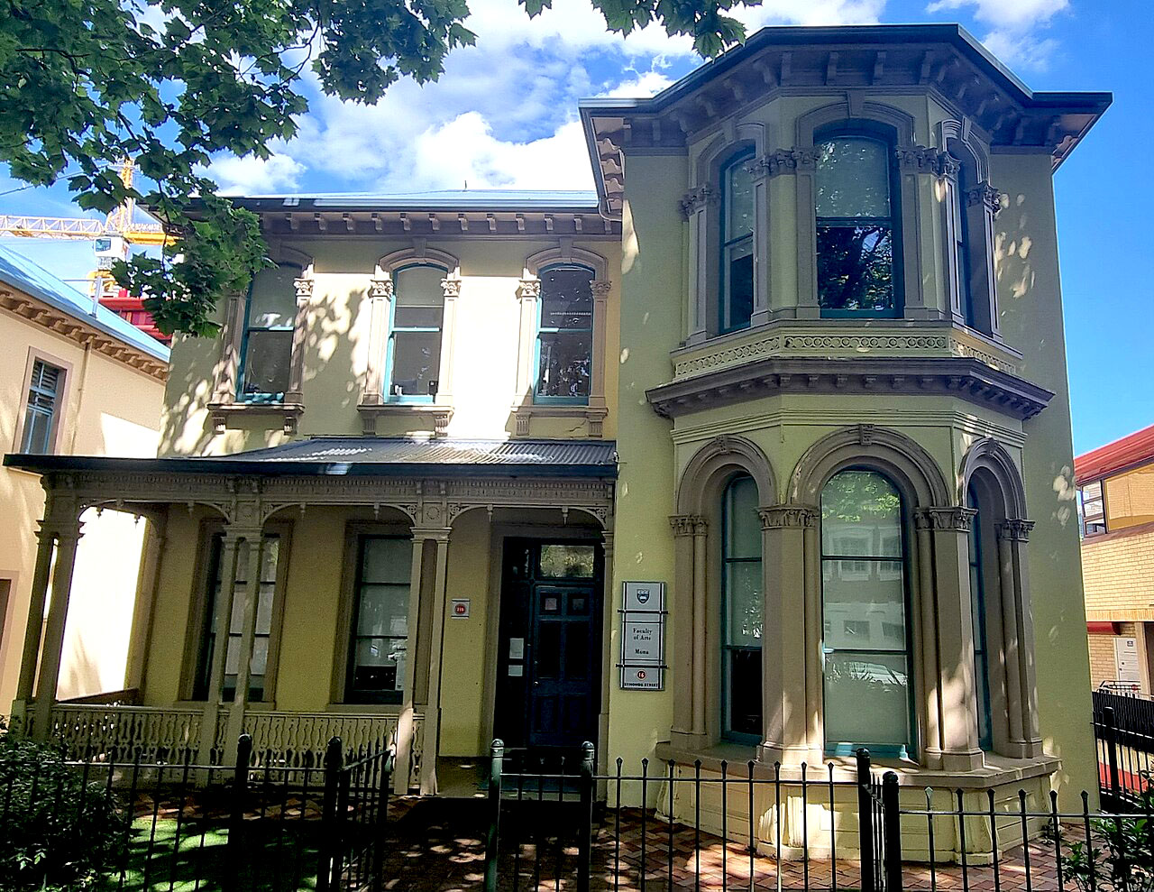
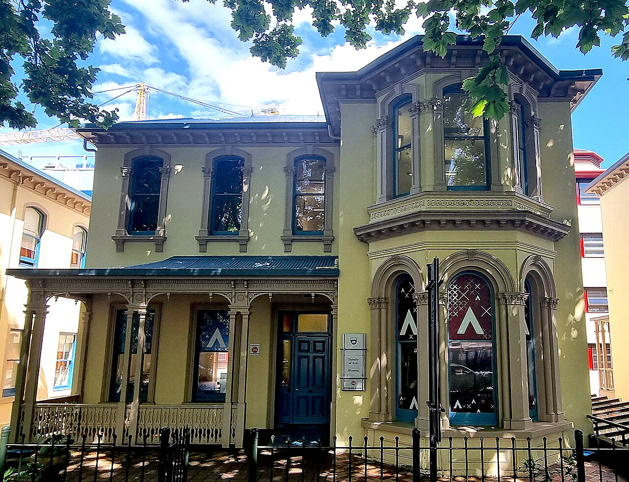
Belgrave is one of a remnant group of three substantial, late-Victorian properties located on the southeast side of lower Symonds Street. Situated in the heart of the University of Auckland campus on the eastern side of Auckland's central business district (CBD), the properties are situated on the crest of the Symonds Street ridge. This section of Symonds Street, a major thoroughfare, is lined with numerous 100-year-old London Plane trees. These are identified in Appendix 2: Schedule of Trees, in Auckland City Council's District Plan. Located within the eastern part of the historic colonial centre of Auckland, Belgrave lies within a broader landscape of outstanding historical and cultural heritage value. In the same block are St Andrew's Church (NZHPT Registration # 20, Category I historic place) which is the oldest surviving stone church in New Zealand, a house at 5 Alten Road (NZHPT Registration # 7398, Category II historic place), two other late-Victorian villas, noted above, and two buildings of early twentieth-century date in Grafton Road. One of the two latter buildings, the plastered brick villa Bayreuth at 10 Grafton Rd, was for a time the home of influential music teachers Johannes Wielaert and wife Katherine Schafe. In the block to the north and east are the colonial governor's residence (Government House (Former), NZHPT Registration # 105, Category I historic place), remnants of the largest military barracks in New Zealand (including the Albert Barracks Wall, NZHPT Registration # 12, Category I historic place), the Old Choral Hall (NZHPT Registration # 4474, Category I historic place) which was one of the major venues for cultural gatherings in colonial Auckland, and the Old Arts Building, University of Auckland (NZHPT Registration # 25, Category I historic place). Numerous other places of considerable significance are located in nearby Waterloo Quadrant and Princes Street, including the former Supreme Court (now the High Court, NZHPT Registration # 17, Category I historic place), a former synagogue (NZHPT Registration # 578, Category I historic place) and several large residences collectively known as former Merchants' Houses. Belgrave is the northernmost of three similar urban properties of late nineteenth-century date, all of which are now encompassed within the Arts and Commerce precinct of the university campus. Belgrave consists of a rectangular 612m² site incorporating a large building of residential design, a small front garden and an extensive open paved area to the rear containing a raised walkway. The current Arts building and its footprint lie within the southeastern part of the property but are excluded from the registration. The ground slopes down considerably from the northwest to the southeast of the site so that the main building is two stories in height at its Symonds Street façade and three storeys high to the southeast. Belgrave is set marginally closer to the front boundary than its neighbours to the southwest, with a grassed garden immediately to its northwest bounded on Symonds Street by a metal railing fence on a low concrete plinth. The fence incorporates a garden gate. Constructed of lime scoria or cement concrete, the villa is rectangular in plan and of Italianate design. Its symmetrical front façade incorporates a full-length verandah that has paired posts with stylised capitals, brackets and arches. The verandah shelters a large centrally-placed door and flanking windows in the lower storey of this facade. Its upper storey mirrors this arrangement with a pair of arch-headed windows with bracketed sills and decorative heads on either side of a single centrally located window of similar design. The side walls of the building are plainer, but that on the southwest contains a similar arrangement of rectangular headed windows at ground floor level and round-headed windows above. Windows on both sides of the building lighting a basement towards the southeast are of a smaller size. The rear façade of the building has been recently rebuilt, but incorporates blind window openings in its upper storey and a simple two-storey verandah at basement and ground floor level. The building has a U-shaped hipped corrugated iron roof with a central gutter. Its eaves are closely bracketed throughout. Internally the ground floor of the building has a central corridor extending southeastwards from the main door, with one room off its northeast side and two rooms off the southwest side. A staircase in the building's southeastern corner connects all three levels. The stairs between ground floor and basement are recent, providing access to toilets and three offices at basement level. An original stairwell linking the ground and first floors is spacious, and is lit by a tall plain-glass sash window with a tilting light for controlled ventilation above. Its staircase contains balustrades and a decorative newel post. The first floor has been partitioned to provide four offices. Fireplaces on all floors have been blocked off or removed. Fire-proof lobbies and smoke-stop doors have been installed throughout.
Belgrave is one of a remnant group of three substantial, late-Victorian properties located on the southeast side of lower Symonds Street. Situated in the heart of the University of Auckland campus on the eastern side of Auckland's central business district (CBD), the properties are situated on the crest of the Symonds Street ridge. This section of Symonds Street, a major thoroughfare, is lined with numerous 100-year-old London Plane trees. These are identified in Appendix 2: Schedule of Trees, in Auckland City Council's District Plan. Located within the eastern part of the historic colonial centre of Auckland, Belgrave lies within a broader landscape of outstanding historical and cultural heritage value. In the same block are St Andrew's Church (NZHPT Registration # 20, Category I historic place) which is the oldest surviving stone church in New Zealand, a house at 5 Alten Road (NZHPT Registration # 7398, Category II historic place), two other late-Victorian villas, noted above, and two buildings of early twentieth-century date in Grafton Road. One of the two latter buildings, the plastered brick villa Bayreuth at 10 Grafton Rd, was for a time the home of influential music teachers Johannes Wielaert and wife Katherine Schafe. In the block to the north and east are the colonial governor's residence (Government House (Former), NZHPT Registration # 105, Category I historic place), remnants of the largest military barracks in New Zealand (including the Albert Barracks Wall, NZHPT Registration # 12, Category I historic place), the Old Choral Hall (NZHPT Registration # 4474, Category I historic place) which was one of the major venues for cultural gatherings in colonial Auckland, and the Old Arts Building, University of Auckland (NZHPT Registration # 25, Category I historic place). Numerous other places of considerable significance are located in nearby Waterloo Quadrant and Princes Street, including the former Supreme Court (now the High Court, NZHPT Registration # 17, Category I historic place), a former synagogue (NZHPT Registration # 578, Category I historic place) and several large residences collectively known as former Merchants' Houses. Belgrave is the northernmost of three similar urban properties of late nineteenth-century date, all of which are now encompassed within the Arts and Commerce precinct of the university campus. Belgrave consists of a rectangular 612m² site incorporating a large building of residential design, a small front garden and an extensive open paved area to the rear containing a raised walkway. The current Arts building and its footprint lie within the southeastern part of the property but are excluded from the registration. The ground slopes down considerably from the northwest to the southeast of the site so that the main building is two stories in height at its Symonds Street façade and three storeys high to the southeast. Belgrave is set marginally closer to the front boundary than its neighbours to the southwest, with a grassed garden immediately to its northwest bounded on Symonds Street by a metal railing fence on a low concrete plinth. The fence incorporates a garden gate. Constructed of lime scoria or cement concrete, the villa is rectangular in plan and of Italianate design. Its symmetrical front façade incorporates a full-length verandah that has paired posts with stylised capitals, brackets and arches. The verandah shelters a large centrally-placed door and flanking windows in the lower storey of this facade. Its upper storey mirrors this arrangement with a pair of arch-headed windows with bracketed sills and decorative heads on either side of a single centrally located window of similar design. The side walls of the building are plainer, but that on the southwest contains a similar arrangement of rectangular headed windows at ground floor level and round-headed windows above. Windows on both sides of the building lighting a basement towards the southeast are of a smaller size. The rear façade of the building has been recently rebuilt, but incorporates blind window openings in its upper storey and a simple two-storey verandah at basement and ground floor level. The building has a U-shaped hipped corrugated iron roof with a central gutter. Its eaves are closely bracketed throughout. Internally the ground floor of the building has a central corridor extending southeastwards from the main door, with one room off its northeast side and two rooms off the southwest side. A staircase in the building's southeastern corner connects all three levels. The stairs between ground floor and basement are recent, providing access to toilets and three offices at basement level. An original stairwell linking the ground and first floors is spacious, and is lit by a tall plain-glass sash window with a tilting light for controlled ventilation above. Its staircase contains balustrades and a decorative newel post. The first floor has been partitioned to provide four offices. Fireplaces on all floors have been blocked off or removed. Fire-proof lobbies and smoke-stop doors have been installed throughout.
Historical and Associated Iwi / Hapū / Whānau
Completion Date
2nd May 2007
Report Written By
Martin Jones and Joan McKenzie
Information Sources
Hodgson, 1992
T. Hodgson, The Heart of Colonial Auckland 1865-1910, Random Century NZ Ltd, Auckland 1992
Sinclair, 1983
Keith Sinclair, A History of the University of Auckland, 1883-1983, Auckland, 1983
Stone, 1973
R. C. J. Stone, Makers of Fortune: A Colonial Business Community and its Fall, Auckland, 1973
Thornton, 1996
Geoffrey Thornton, Cast in Concrete: Concrete Construction in New Zealand 1850-1939, Auckland, 1996
Trembath, 1969
K.A. Trembath, Ad Augusta: A Centennial History of Auckland Grammar School 1869-1969, Auckland, 1969.
Other Information
A fully referenced registration report is available from the NZHPT Northern Region Office Please note that entry on the New Zealand Heritage List/Rarangi Korero identifies only the heritage values of the property concerned, and should not be construed as advice on the state of the property, or as a comment of its soundness or safety, including in regard to earthquake risk, safety in the event of fire, or insanitary conditions.
Current Usages
Uses: Education
Specific Usage: University
Former Usages
General Usage: Accommodation
Specific Usage: Boarding/ Guest House
General Usage: Accommodation
Specific Usage: Complex of flats
General Usage: Accommodation
Specific Usage: House
General Usage: Education
Specific Usage: University
Location
Related listings
Sign up to hear more
Get the latest heritage news, features and events delivered
straight to your inbox.
