

Building railways was key to New Zealand’s development. The Governor, Sir George Bowen, turned the first sod of the Dunedin-Balclutha railway on 18 March 1871, and four years later this section of the railway was opened for traffic, with the train steaming into the siding alongside the Clutha River. A steamer carried the passengers to the opposite bank. Bridging the mighty Clutha was the next step.
In 1873, the Public Works Department made a tracing of the proposed site for the bridge. District Engineer William Newsham Blair designed the bridge. Blair (1841-1891) was born in Scotland. First articled to a firm of engineers and surveyors at Oban in 1861 he joined the firm of Sir Thomas Bouch, constructor of the Tay Bridge. In 1863 he came to New Zealand, and in 1864 joined the Otago Provincial Council staff. His work generally concerned railways, rail and road bridges, waterworks, and the Port Chalmers Wharf. In 1871 he was appointed District Engineer, Dunedin for the Public Works Department. In 1878 he became Engineer-in-Chief of the South Island. He became deeply involved in planning the development of the South Island railways, particularly the linkages from Canterbury to the West Coast and Nelson. In 1884 he was appointed Assistant Engineer-in-Chief of the Department, and became involved in the planning for the North Island Main Trunk line. In 1890 he became Engineer-in-Chief and Under Secretary for the Public Works Department. The contractor was James Mackay.
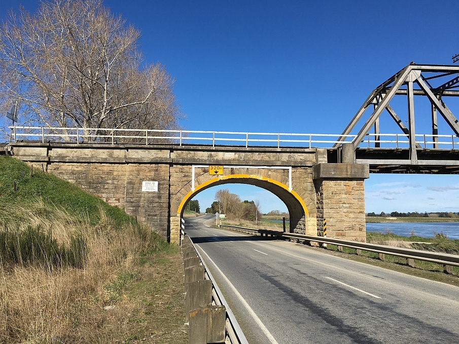
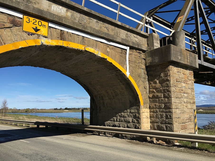
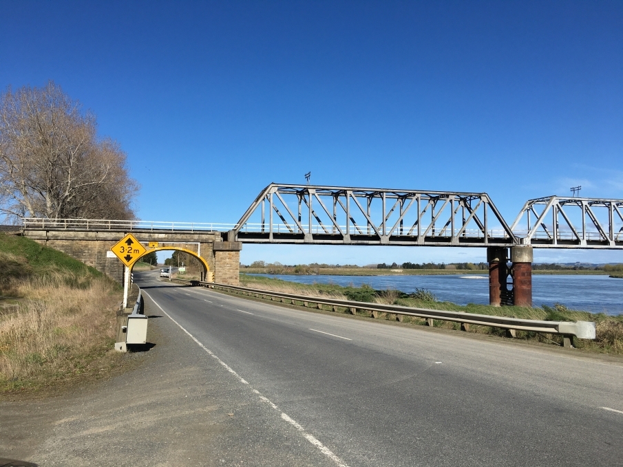
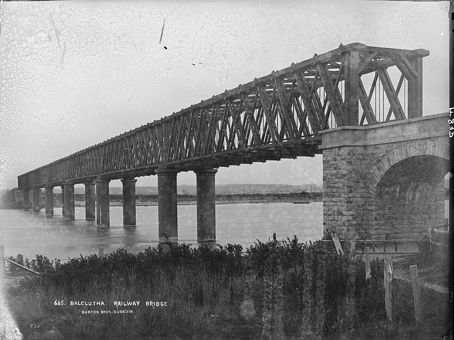
The first contract was let in 1874, for the seven 120 foot (36 metre) timber spans at a cost of £21,253. The 7 foot (2.1 metre) piers each consisted of two cast iron concrete-filled piles range in height from 57 feet to 81 feet (17.1 metres to 24.3 metres). The northern abutment passes over the Kaitangata Highway and has a stone arch spanning the road. At the time the bridge was built, it was, according to architect and engineering historian Geoffrey Thornton, the largest bridge of its kind in the South Island. The Minister of Public Works, the Right Hon. William Larnach opened the bridge on 22 January 1878, naming it the Blair Bridge. The main line through to Invercargill was finished in January 1879.
Since construction, ‘Bridge 297’, as it was known by the Railways Department, has required repair and strengthening work. Finally, between 1966 and 1978, the timber spans were replaced by steel trusses.
In 2015, the Blair Bridge is still in service on the Main South Line.
List Entry Information
Status
Listed
List Entry Status
Historic Place Category 2
Access
Private/No Public Access
List Number
5207
Date Entered
19th April 1990
Date of Effect
19th April 1990
City/District Council
Clutha District
Region
Otago Region
Extent of List Entry
Extent includes part of the land described as Main South Line (Pt Railway Reserve), Legal River, Legal Road, Otago Land District, and the structure known as Blair Bridge, thereon. Refer to the extent map tabled at the Heritage New Zealand Board meeting on 3 September 2015.
Legal description
Main South Line (Pt Railway Reserve), Legal River, Legal Road, Otago Land District
Location Description
GPS (NZTM): N4873928.9, E1349917.8
Construction Professional
Name
Blair, William Newsham
Type
Engineer
Biography
Blair (1841-1891) was born in Scotland. First articled to a firm of engineers and surveyors at Oban in 1861 he joined the firm of Sir Thomas Bouch, constructor of the Tay Bridge. In 1863 he came to New Zealand, and in 1864 joined the Otago Provincial Council staff. His work generally concerned railways, rail and road bridges, waterworks, and the Port Chalmers Wharf. In 1871 he was appointed District Engineer, Dunedin for the Public Works Department. In 1878 he became Engineer-in-Chief of the South Island. He became deeply involved in planning the development of the South Island railways, particularly the linkages from Canterbury to the West Coast and Nelson. In 1884 he was appointed Assistant Engineer-in-Chief of the Department, and became involved in the planning for the North Island Main Trunk line. In 1890 he became Engineer-in-Chief and Under Secretary for the Public Works Department. In 1875 he published "Building Materials of Otago" which had special reference to the use of Oamaru stone. In 1877 he was elected a Member of the Institution of Civil Engineers.
Construction Details
Start Year
1878
Type
Original Construction
Description
Bridge opened 22 January 1878
Type
Modification
Description
Timber trusses replaced by steel trusses
Period
1966-1978
Historical and Associated Iwi / Hapū / Whānau
Completion Date
24th June 2015
Report Written By
Heather Bauchop
Information Sources
Thornton, 2001
Geoffrey Thornton, Bridging the Gap, Early Bridges in New Zealand 1830-1939, Auckland, 2001
Waite, 1948
F. Waite, Pioneering in South Otago, Otago Centennial Historical Publications, Dunedin, 1948
Other Information
This place was identified as significant under previous legislation with different information requirements. It remains significant under the current legislation. There is opportunity under our legislation and policies to add to this information. Further information about this place may be available from the Otago/Southland Office of Heritage New Zealand Pouhere Taonga. Please note that entry on the New Zealand Heritage List/Rarangi Korero identifies only the heritage values of the property concerned, and should not be construed as advice on the state of the property, or as a comment of its soundness or safety, including in regard to earthquake risk, safety in the event of fire, or insanitary conditions. A fully referenced upgrade report is available on request from the Otago/Southland Office of Heritage New Zealand
Current Usages
Uses: Transport
Specific Usage: Bridge/ Viaduct
Uses: Transport
Specific Usage: Rail - transport - other
Current Usages
Uses: Transport
Specific Usage: Bridge/ Viaduct
Uses: Transport
Specific Usage: Rail - transport - other
Location
Stay up to date with Heritage this month
