

Ngāi Tahu whānui had developed a complex series of trails throughout Te Waipounamu over generations of occupation, connecting kainga with one another and to mahinga kai (food gathering places) and other significant tribal resources. These ara tawhito (traditional travel routes) became the arteries of economic and social life and formed the relationships between people and places. This includes the routes leading to and from Whakatipu Wai Māori (Lake Wakatipu). Kimiākau (the Shotover River) was such an artery of life – being an important mahinga kai, as well as ara tawhito. In 1862 a large gold rush on the Shotover River, at the time dubbed ‘the richest river in the world’, turned a quiet piece of paradise into a seething mass of prospectors. Miners undertook various methods to part the gold from the land and water – including the panning of river gravels, alluvial mining along riverbanks, and dredging – as time passed, the returns from remaining gold deposits lessened to the extent that miners had to become inventive with methods to provide better access to deposits just out of reach, beneath the roiling waters of the Shotover rapids. A series of rapids above Arthurs Point had been dubbed by early miners as ‘the Jeweller’s Shop’, fabled for the bounty of gold that could be extracted but for the treacherous water flow.
The Oxenbridge Brothers started an ambitious operation, to divert a large part of the Shotover away from the ‘Jeweller’s Shop’ through a tunnel in a bend of the Shotover, from 1906. By October of 1907, it was reported that 180 ft (55 m) of the total expected length of 550 ft (168 m) had been excavated. At this time, the expected dimensions of the tunnel were 10 ft (3 m) high and 12 ft (3.7 m) wide. By 1909 it had been discovered that the original dimensions would not be enough to allow for a large enough volume of water to pass through; as such further work had to be undertaken to widen the tunnel by 3 ft (0.9m) and deepen it by 2 ft (0.6 m). The continuing financial pressure (without any significant return) this extra work created led to the incorporation of The Arthurs Point Gold Mining Company Limited in October 1909 – a total of 2000 shares were allotted at this time, providing what was hoped to be the necessary finance for continuing work. However, the first return from the tunnel project did not occur until 1911; the amount returned was in no way adequate to help the company pay its debt to creditors or shareholders. By August 1912, the company was put into liquidation.
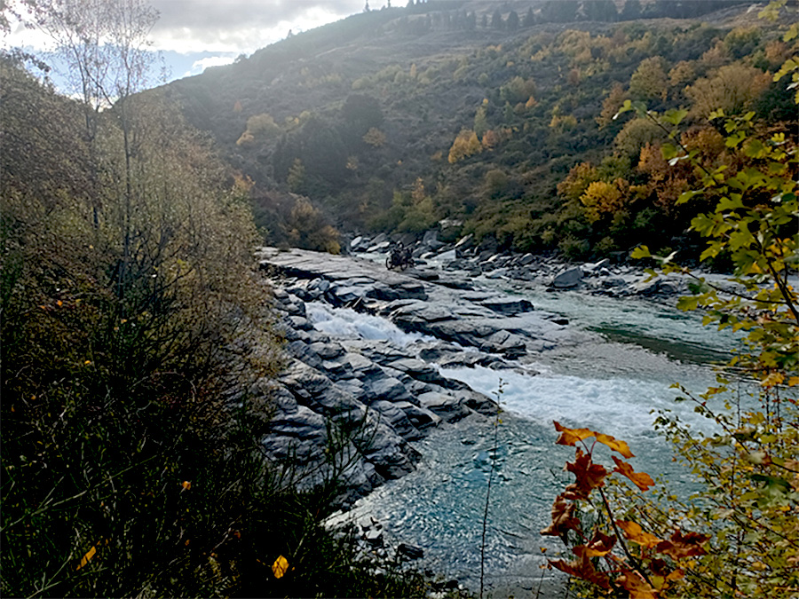
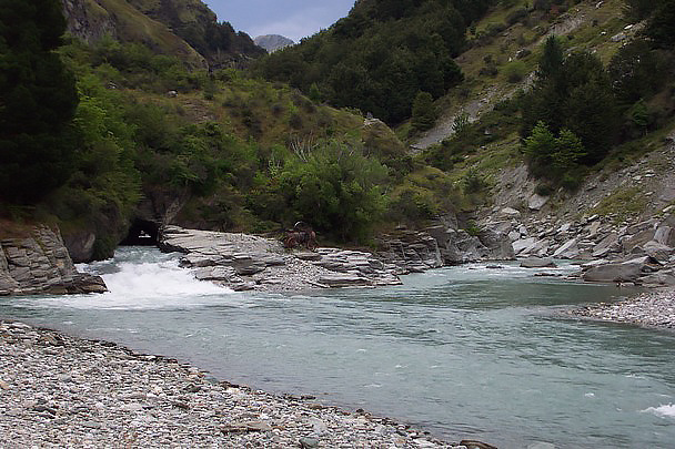
There is no evidence that the tunnel was used for mining purposes following 1912. The Oxenbridge Brothers moved to mine farther up the Shotover, eventually being successful enough to sell up to a consortium for a handsome sum. By the late-20th century the tunnel, along with the rest of this part of the Shotover, was mostly used for tourism purposes, particularly rafting ventures. The 1995 death of an American tourist led to the filling in of the ‘Toaster’, the farthest north of the two original outlet channels from the tunnel exit. As of 2023, the tunnel is still part of the flow of the Shotover River, and primarily used by rafting companies.
List Entry Information
Status
Listed
List Entry Status
Historic Place Category 2
Access
Private/No Public Access
List Number
5607
Date Entered
4th June 1985
Date of Effect
4th June 1985
City/District Council
Queenstown-Lakes District
Region
Otago Region
Extent of List Entry
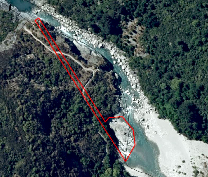
Extent includes part of the land described as Pt Sec 148, Block XIX Shotover SD (RT OT18B/672) and part of the land described as Legal River, Otago Land District and the structure known as Oxenbridge Tunnel and its exit channels, thereon. Refer to the extent map tabled at the Rārangi Kōrero Committee meeting on 28th September 2023
Legal description
Pt Sec 148, Block XIX Shotover SD (RT OT18B/672), Legal River, Otago Land District
Status
Listed
List Entry Status
Historic Place Category 2
Access
Private/No Public Access
List Number
5607
Date Entered
4th June 1985
Date of Effect
4th June 1985
City/District Council
Queenstown-Lakes District
Region
Otago Region
Extent of List Entry
Extent includes part of the land described as Pt Sec 148, Block XIX Shotover SD (RT OT18B/672) and part of the land described as Legal River, Otago Land District and the structure known as Oxenbridge Tunnel and its exit channels, thereon. Refer to the extent map tabled at the Rārangi Kōrero Committee meeting on 28th September 2023
Legal description
Pt Sec 148, Block XIX Shotover SD (RT OT18B/672), Legal River, Otago Land District
Construction Professional
Name
Bert and Edmund Oxenbridge
Type
Builder
Biography
Construction Details
Start Year
1909
Type
Modification
Description
Tunnel widened and deepened
Start Year
1995
Type
Modification
Description
Blocking of the ‘Toaster’ outlet
Start Year
1906
Type
Original Construction
Description
Tunnel commenced
Historical and Associated Iwi / Hapū / Whānau
Public NZAA Number
E41/94
Completion Date
17th May 2023
Report Written By
Andrew Winter
Other Information
This place was identified as significant under previous legislation with different information requirements. It remains significant under the current legislation. There is opportunity under our legislation and policies to add to this information. Further information about this place may be available from the Otago/Southland Office of Heritage New Zealand Pouhere Taonga. A fully referenced copy of the Upgrade Report is available upon request from the Otago/Southland Area Office of Heritage New Zealand Pouhere Taonga Please note that entry on the New Zealand Heritage List/Rarangi Korero identifies only the heritage values of the property concerned, and should not be construed as advice on the state of the property, or as a comment of its soundness or safety, including in regard to earthquake risk, safety in the event of fire, or insanitary conditions.
Current Usages
Uses: Civic Facilities
Specific Usage: Recreation Reserve/Scenic Reserve
Former Usages
General Usage: Mining
Specific Usage: Mine Water Race/ Water Race cuttings/tunnels etc
Current Usages
Uses: Civic Facilities
Specific Usage: Recreation Reserve/Scenic Reserve
Former Usages
General Usage: Mining
Specific Usage: Mine Water Race/ Water Race cuttings/tunnels etc
Sign up to hear more
Get the latest heritage news, features and events delivered
straight to your inbox.
