DonateSupporterVisit Heritage
  • Tūrangawaewae
    Places
  • Tira Māori
    Māori Heritage
  • Poutairangahia
    Archaeology
  • Rauemi
    Resources
  • Mō Tātou
    About Us
  • New Zealand Heritage List
  • Nominate and submit
  • Explore the List
  • National Historic Landmarks
  • Plaques
  • Rainbow List Project
  • Lost heritage
  • Visit Heritage
  • Our properties
  • Turnbull House Project
  • Collections
  • Shop
  • Tohu Whenua
  • Tira Māori
  • Conserving Māori heritage
  • Marae built heritage
  • Māori heritage on the List
  • Hinemihi—Te Hokinga Mai
  • What is archaeology?
  • Is there a site on my property?
  • What are my legal requirements?
  • Affecting an archaeological site
  • Declaring an archaeological site
  • Archaeology FAQs
  • Archaeology Digital Library
  • Archaeology guidelines and templates
  • Resources
  • Funding
  • Publications
  • Sustainable management guides
  • Disaster recovery
  • Podcasts & digital resources
  • Education Hub
  • Conservation plans
  • About
  • Board
  • Māori Heritage Council
  • Senior Staff
  • Offices
  • Contact us
  • Careers
  • Covenants
  • Fast-track
  • Corporate documents
  • Currently consulting on
  • Our submissions
  • News
Quick links
Rārangi Kōrero | The List
Explore the List
National Historic Landmarks
Ngā Manawhenua o Aotearoa me ōna Kōrero Tūturu
Quick links
Tapuwae
A Vision for Places of Māori Heritage
Funding for Māori Heritage
Resources
Quick links
Archaeological Authority Portal
Applying for an archaeological authority
Archaeology FAQs
Browse the most frequently asked questions about archaeological authorities and the archaeological process.
Quick links
Quick links
Contact us
Offices
DonateSupporterVisit Heritage
  • Tūrangawaewae
    Places
  • Tira Māori
    Māori Heritage
  • Poutairangahia
    Archaeology
  • Rauemi
    Resources
  • Mō Tātou
    About Us
  • New Zealand Heritage List
  • Nominate and submit
  • Explore the List
  • National Historic Landmarks
  • Plaques
  • Rainbow List Project
  • Lost heritage
  • Visit Heritage
  • Our properties
  • Turnbull House Project
  • Collections
  • Shop
  • Tohu Whenua
  • Tira Māori
  • Conserving Māori heritage
  • Marae built heritage
  • Māori heritage on the List
  • Hinemihi—Te Hokinga Mai
  • What is archaeology?
  • Is there a site on my property?
  • What are my legal requirements?
  • Affecting an archaeological site
  • Declaring an archaeological site
  • Archaeology FAQs
  • Archaeology Digital Library
  • Archaeology guidelines and templates
  • Resources
  • Funding
  • Publications
  • Sustainable management guides
  • Disaster recovery
  • Podcasts & digital resources
  • Education Hub
  • Conservation plans
  • About
  • Board
  • Māori Heritage Council
  • Senior Staff
  • Offices
  • Contact us
  • Careers
  • Covenants
  • Fast-track
  • Corporate documents
  • Currently consulting on
  • Our submissions
  • News
Quick links
Rārangi Kōrero | The List
Explore the List
National Historic Landmarks
Ngā Manawhenua o Aotearoa me ōna Kōrero Tūturu
Quick links
Tapuwae
A Vision for Places of Māori Heritage
Funding for Māori Heritage
Resources
Quick links
Archaeological Authority Portal
Applying for an archaeological authority
Archaeology FAQs
Browse the most frequently asked questions about archaeological authorities and the archaeological process.
Quick links
Quick links
Contact us
Offices
  • Places
  • Nominate and submit
  • National Historic Landmarks
  • Places
  • Nominate and submit
  • National Historic Landmarks
  • Tira Māori
  • Conserving Māori heritage
  • Marae built heritage
  • Tira Māori
  • Conserving Māori heritage
  • Marae built heritage
  • Archaeological authorities
  • Archaeology Digital Library
  • Archaeological authorities
  • Archaeology Digital Library
  • All resources
  • Publications
  • Funding
  • All resources
  • Publications
  • Funding
  • FAQs
  • FAQs
Follow us on:
Places
  • Places
  • Nominate and submit
  • National Historic Landmarks
Tira Māori
  • Tira Māori
  • Conserving Māori heritage
  • Marae built heritage
Archaeology
  • Archaeological authorities
  • Archaeology Digital Library
Resources
  • All resources
  • Publications
  • Funding
FAQs
  • FAQs
Follow us on
HomePrivacyTerms and conditionsAbout this site
© Heritage New Zealand Pouhere Taonga 2026.
 
Adams Gully Gold Battery Complex

Carrick Range, CENTRAL OTAGO

Public

Historic Place Category 2

List No. 5616

Quick links:
List GalleryLocationDetails

High on the Carrick Range at the head of Adams Gully overlooking Bannockburn in Otago sits the Adams Gully Gold Battery Complex – a battery, stone ruin and dam associated with the Young Australian quartz mine in the 1870s. The complex has technological, historical and archaeological significance showing the workings of a nineteenth century hard rock gold mine in this rugged region.

The Carrick Range was home to a cluster of hard rock gold mines and their associated stamper mills or batteries from the 1870s through until around the end of the nineteenth century. In October 1872, Adam’s Gully Quartz Mining Company and the Young Australian Mine were crushing quartz at the head of Adams Gully. In June 1874, Williams and Edwards from the Young Australian Company decided to put in their own battery and bought the ten-stamp battery from the Andreas Iverson’s Conroy’s Reef near Alexandra; by early 1875, the battery was in its new location, powered by a water wheel. By 1877, the company was struggling and the mine was sold by creditors. In 1880, a Mr Radford bought the battery, crushing stone until 1884 when he sold it to Louis Jean Hubert. The mine was abandoned for some years. It is possible that half the stamper mill was shifted to its current location when McCabe & Sons of Bannockburn reopened the mine in 1896 – operating five stamps, powered by a Pelton wheel.

The Adams Gully gold battery complex includes almost all of the elements needed to run a gold mining operation. As well as a five-head stamping battery, there is a berdan, or crushing bowl, with its iron weight lying on the ground alongside; an amalgamating drum, and the remains of a building (possibly a forge). The complex is built on a stone-faced platform or terrace with a stone wall alongside the battery and berdan. Approximately 30 m upstream from the battery, the remains of a dam can be seen in the stream bed. It may have provided water for the crusher, although it is more likely that the water was supplied by the Carrick Water Race, which passes about 100 m upstream of the complex.

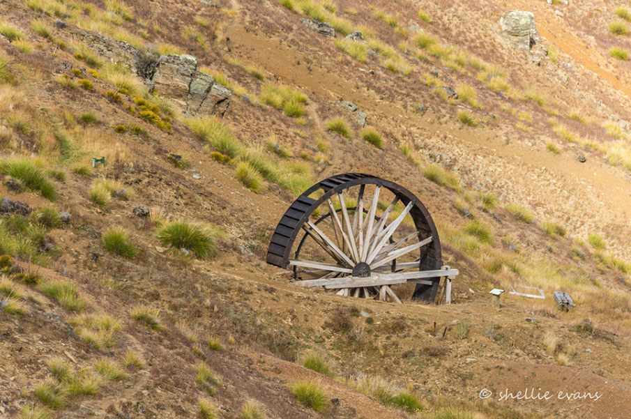
In 2015, the Adams Gully Battery Complex is within the Young Australian Historic Reserve, and can be seen on the hillside opposite the Young Australian Water Wheel (List Entry No. 342).
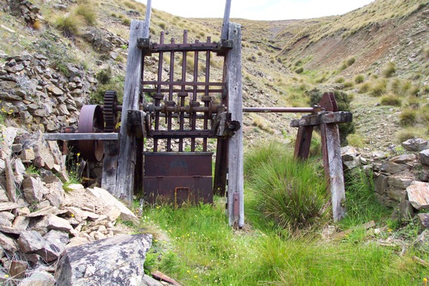
Adams Gully Battery Complex, Central Otago | Heritage New Zealand Pouhere Taonga
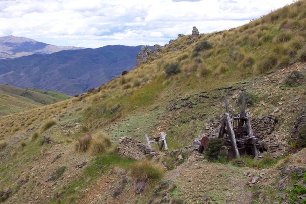
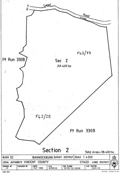
Adams Gully Battery Complex, Central Otago | 01/10/1983 | Heritage New Zealand Pouhere Taonga
Adams Gully Battery Complex, Central Otago | Heritage New Zealand Pouhere Taonga
Adams Gully Battery Complex, Central Otago | 01/10/1983 | Heritage New Zealand Pouhere Taonga


List Entry Information

Overview

Status
Listed

List Entry Status
Historic Place Category 2

Access
Able to Visit

List Number
5616

Date Entered
11th April 1985

Date of Effect
11th April 1985

City/District Council
Central Otago District

Region
Otago Region

Extent of List Entry

Extent includes part of the land described as Sec 2 Blk III Bannockburn SD, (RT 3164), Otago Land District, and the sites associated with the Adams Gully Gold Battery Complex thereon. Refer to the extent map tabled at the Heritage New Zealand Board meeting on 30 April 2015.

Legal description

Sec 2 Blk III Bannockburn SD, (RT 3164), Otago Land District

Location Description

Dam: E1292679 N4994443 (NZTM) Battery: E1292710 N4994454 (NZTM) Hut Ruins: E1292727 N4994471 (NZTM) In an unnamed tributary of Adams Creek, opposite the Young Australian Water Wheel.

Detailed List Entry

Construction Details

Start Year

1871

Type

Original Construction

Description

Battery manufactured

Start Year

1875

Type

Relocation

Description

Battery shifted from Conroys Gully to Adams Gully

Start Year

1896

Type

Relocation

Description

Battery shifted from site next to the Young Australian Water Wheel to its current site on the opposite side of the gully.

Reference

Public NZAA Number

F42/25

Completion Date

16th February 2015

Report Written By

Heather Bauchop

Report Written By

This place was identified as significant under previous legislation with different information requirements. It remains significant under the current legislation. There is opportunity under our legislation and policies to add to this information. Further information about this place may be available from the Otago/Southland Office of Heritage New Zealand Pouhere Taonga. Please note that entry on the New Zealand Heritage List/Rarangi Korero identifies only the heritage values of the property concerned, and should not be construed as advice on the state of the property, or as a comment of its soundness or safety, including in regard to earthquake risk, safety in the event of fire, or insanitary conditions. A fully referenced upgrade report is available on request from the Otago/Southland Office of Heritage New Zealand

Further Information

Current Usages

Uses: Ruin

Specific Usage: Misc Archaeological

Former Usages

General Usage:: Mining

Specific Usage: Battery/Crusher

General Usage:: Mining

Specific Usage: Mine buildings

General Usage:: Mining

Specific Usage: Mine reservoir/ dam

Themes

Web Links

Overview

Status

Listed

List Entry Status

Historic Place Category 2

Access

Able to Visit

List Number

5616

Date Entered

11th April 1985

Date of Effect

11th April 1985

City/District Council

Central Otago District

Region

Otago Region

Extent of List Entry

Extent includes part of the land described as Sec 2 Blk III Bannockburn SD, (RT 3164), Otago Land District, and the sites associated with the Adams Gully Gold Battery Complex thereon. Refer to the extent map tabled at the Heritage New Zealand Board meeting on 30 April 2015.

Legal description

Sec 2 Blk III Bannockburn SD, (RT 3164), Otago Land District

Location Description

Dam: E1292679 N4994443 (NZTM) Battery: E1292710 N4994454 (NZTM) Hut Ruins: E1292727 N4994471 (NZTM) In an unnamed tributary of Adams Creek, opposite the Young Australian Water Wheel.

Status

Listed

List Entry Status

Historic Place Category 2

Access

Able to Visit

List Number

5616

Date Entered

11th April 1985

Date of Effect

11th April 1985

City/District Council

Central Otago District

Region

Otago Region

Extent of List Entry

Extent includes part of the land described as Sec 2 Blk III Bannockburn SD, (RT 3164), Otago Land District, and the sites associated with the Adams Gully Gold Battery Complex thereon. Refer to the extent map tabled at the Heritage New Zealand Board meeting on 30 April 2015.

Legal description

Sec 2 Blk III Bannockburn SD, (RT 3164), Otago Land District

Location Description

Dam: E1292679 N4994443 (NZTM) Battery: E1292710 N4994454 (NZTM) Hut Ruins: E1292727 N4994471 (NZTM) In an unnamed tributary of Adams Creek, opposite the Young Australian Water Wheel.

Construction Information

Construction Details

Start Year

1871

Type

Original Construction

Description

Battery manufactured

Start Year

1875

Type

Relocation

Description

Battery shifted from Conroys Gully to Adams Gully

Start Year

1896

Type

Relocation

Description

Battery shifted from site next to the Young Australian Water Wheel to its current site on the opposite side of the gully.

Construction Details

Start Year

1871

Type

Original Construction

Description

Battery manufactured

Start Year

1875

Type

Relocation

Description

Battery shifted from Conroys Gully to Adams Gully

Start Year

1896

Type

Relocation

Description

Battery shifted from site next to the Young Australian Water Wheel to its current site on the opposite side of the gully.

Reference

Historical and Associated Iwi / Hapū / Whānau

Public NZAA Number

F42/25

Completion Date

16th February 2015

Report Written By

Heather Bauchop

Other Information

This place was identified as significant under previous legislation with different information requirements. It remains significant under the current legislation. There is opportunity under our legislation and policies to add to this information. Further information about this place may be available from the Otago/Southland Office of Heritage New Zealand Pouhere Taonga. Please note that entry on the New Zealand Heritage List/Rarangi Korero identifies only the heritage values of the property concerned, and should not be construed as advice on the state of the property, or as a comment of its soundness or safety, including in regard to earthquake risk, safety in the event of fire, or insanitary conditions. A fully referenced upgrade report is available on request from the Otago/Southland Office of Heritage New Zealand

Historical and Associated Iwi / Hapū / Whānau

Public NZAA Number

F42/25

Completion Date

16th February 2015

Report Written By

Heather Bauchop

Other Information

This place was identified as significant under previous legislation with different information requirements. It remains significant under the current legislation. There is opportunity under our legislation and policies to add to this information. Further information about this place may be available from the Otago/Southland Office of Heritage New Zealand Pouhere Taonga. Please note that entry on the New Zealand Heritage List/Rarangi Korero identifies only the heritage values of the property concerned, and should not be construed as advice on the state of the property, or as a comment of its soundness or safety, including in regard to earthquake risk, safety in the event of fire, or insanitary conditions. A fully referenced upgrade report is available on request from the Otago/Southland Office of Heritage New Zealand

Further Information

Current Usages

Uses: Ruin

Specific Usage: Misc Archaeological

Former Usages

General Usage: Mining

Specific Usage: Battery/Crusher

General Usage: Mining

Specific Usage: Mine buildings

General Usage: Mining

Specific Usage: Mine reservoir/ dam

Current Usages

Uses: Ruin

Specific Usage: Misc Archaeological

Former Usages

General Usage: Mining

Specific Usage: Battery/Crusher

General Usage: Mining

Specific Usage: Mine buildings

General Usage: Mining

Specific Usage: Mine reservoir/ dam

Location

Loading
Related listings
Young Australian Mine Company Waterwheel, Carrick Range. Image courtesy of www.flickr.com
Young Australian Mine Company Waterwheel
Young Australian Mine Company Waterwheel, Carrick Range. Image courtesy of www.flickr.com
Young Australian Mine Company Waterwheel
Sign up to hear more

Get the latest heritage news, features and events delivered
straight to your inbox.

Subscribe