

Te Raka a Hineatua is a well-positioned coastal pā site set at the end of a narrow isthmus on an elongated peninsula with two sheer cliff faces on the western and southern sides. Within easy reach of a plethora of marine resources; small sandy beaches nearby for tauraka waka; and handy access to forest and other resources for building materials and food sources – the pā site was well utilised for several generations.
Te Raka a Hineatua was built under the mantle of Taoka, the son of Te Ruahikihiki and Te Aotaurewa of Taumutu. Soon after the pā was built, an tauā (war pārty) of Kaikoura and Kaiapoi people arrived under the leadership of Tawhakiterangi, Te Mātauira, Tūāhuriri II, Te Ruapāpā, Pōkeka and Pārakiore. The large combined force was considered to be one of the biggest that was ever collected. Taoka and his people beat the tauā in the battle which became known as Te Hakopā. Taoka was a well-known fighting chief and participated in some of the last battles with Kāti Māmoe in Ōtākou before eventually dying in his bed of old age at Katiki.
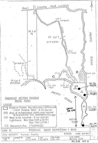
The story of day to day living at the pā is often uncovered by archaeologists who study the tangible vestiges left behind by tūpuna. The metre thick occupation layer contains middens exposing the resources utilised by the occupants. The bones of barracoota, ling and other fish as well as the shells from pāua, mussel, whelk and limpets, pipi and cockle are found in the middens. Fauna species like duck, shags, penguin, rat, fur seal, dog and whale, even a kaka are present. These are all indicators of the bountiful variety of kai available. The remnants of the heavy Totara slabs used to construct the whare and the well-considered slight sloping terracing for water runoff are attributes of the forethought and effort involved in the construction of the pā. Archaeologist Michael Trotter, who excavated the site in the 1960s, writes that the terraced pā covered about five acres (2 hectares). The site has three sections – the mainland, a peninsula separated by a neck and a rocky island accessible at low tide. Terraces exist on all slopes, and ‘appear to have been constructed for use as building sites.’ Some of the terraces were damaged when the Moeraki Lighthouse was constructed in 1877.
Archaeological evidence shows the main features of the pā sites have been terraces for houses, traces of ditch-and-bank defences and midden material with later style artefacts. At Te Raka a Hineatua there are terraces on both sides of the neck of the peninsula. Excavations indicate the presence of rectangular houses built of wooden slabs with square stone fireplaces and associated midden containing later style artefacts (for example, greenstone adzes). Carbon dating indicates that the pā was occupied in the eighteenth century. At this time the main Māori settlement in North Otago was to the north of Katiki at the Moeraki kaik. Associated with Te Raka a Hineatua are several recorded archaeological sites included within the List entry boundary. Three associated sites have separate List entries – providing details about how people lived at the pā, describing the terracing of the pā, cooking and domestic life (Terraces/Midden List No. 5696, Ovens List No. 5697, Midden, List No. 5698).
Trotter concluded that the site was occupied in the mid-eighteenth century, that the ‘artifactural assemblage is typologically later, and the occupants of the site were doubtless of the Ngāi Tahu tribe. Rectangular buildings constructed with dressed totara slab uprights were erected on terraces apparently levelled for that purpose, although pits of as yet unknown use are present on the site. All foods represented by midden remains were available in the vicinity and materials for artefact manufacture were with the exception of nephrite, largely of local origin, indicating a good knowledge of available resources.’
In later years the pā (on which a lighthouse was built in 1878) became part of a historic reserve. As part of the Ngai Tahu Claims Settlement, the Kātiki Point Historic Reserve has been vested in Te Runanga o Ngai Tahu who manage the area in conjunction with Te Runanga o Moeraki, who hold manawhenua of the area. In 2016, Te Raka a Hineatua is a popular site with visitors who can read about the history of the area and watch the seals and other wildlife that live on Katiki Point. Installation of new fencing, improved signage and a new whakaruruhau (gateway) is currently being undertaken to not only acknowledge the history and significance of the site, but to guide visitor behaviour and enhance their experience by providing information on how best to interact with the environment and the wildlife found there.

List Entry Information
Status
Listed
List Entry Status
Historic Place Category 2
Access
Able to Visit
List Number
5695
Date Entered
11th March 1985
Date of Effect
11th March 1985
City/District Council
Waitaki District
Region
Otago Region
Legal description
Lot 2 DP 27582 (RT 84913), Otago Land District
Status
Listed
List Entry Status
Historic Place Category 2
Access
Able to Visit
List Number
5695
Date Entered
11th March 1985
Date of Effect
11th March 1985
City/District Council
Waitaki District
Region
Otago Region
Legal description
Lot 2 DP 27582 (RT 84913), Otago Land District
Construction Professional
Name
Taoka
Type
Builder
Biography
No biography is currently available for this construction professional
Construction Details
Type
Other
Description
Occupied from 1300-1800
Period
1300-1800
Construction Professional
Name
Taoka
Type
Builder
Biography
No biography is currently available for this construction professional
Construction Details
Type
Other
Description
Occupied from 1300-1800
Period
1300-1800
Historical and Associated Iwi / Hapū / Whānau
Public NZAA Number
J42/20
Completion Date
31st January 2017
Report Written By
Heather Bauchop
Information Sources
Anderson, 1998
Atholl Anderson, The Welcome of Strangers: An ethnohistory of southern Maori A.D. 1650-1850, Otago University Press in association with the Dunedin City Council, Dunedin, 1998
Canterbury Museum
Canterbury Museum
Hamel, 2001
Jill Hamel, The Archaeology of Otago, Department of Conservation, Wellington, 2001
Potts, 2013
Kirsty N. Potts, ‘Murihiku Pā: An Investigation of Pā Sites in the Southern Areas of New Zealand,’ MA Thesis, University of Otago, October 2013
Other Information
This place was identified as significant under previous legislation with different information requirements. It remains significant under the current legislation. There is opportunity under our legislation and policies to add to this information. Further information about this place may be available from the Otago/Southland Office of Heritage New Zealand Pouhere Taonga. Please note that entry on the New Zealand Heritage List/Rarangi Korero identifies only the heritage values of the property concerned, and should not be construed as advice on the state of the property, or as a comment of its soundness or safety, including in regard to earthquake risk, safety in the event of fire, or insanitary conditions. A fully referenced upgrade report is available on request from the Otago/Southland Office of Heritage New Zealand.
Former Usages
General Usage: Cultural Landscape
Specific Usage: Ancestral landscape
General Usage: Maori
Specific Usage: Pā
General Usage: Maori
Specific Usage: Site of historical event
Themes
Of Significance to Maori
Former Usages
General Usage: Cultural Landscape
Specific Usage: Ancestral landscape
General Usage: Maori
Specific Usage: Pā
General Usage: Maori
Specific Usage: Site of historical event
Themes
Of Significance to Maori
Location

Sign up to hear more
Get the latest heritage news, features and events delivered
straight to your inbox.
