

The Newton Fire Brigade was established two years after the Borough's connection to Auckland City Council's water supply in 1887. It took over responsibility from the Insurance Companies Association's Fire Patrol and Salvage Corps, which patrolled areas outside Auckland. The Auckland City's Fire Brigade's obligations extended only as far as the city boundaries. Until construction of the new premises, the Newton Brigade held its meetings and stored its equipment at the City brigade's Karangahape Fire Station. The day-to-day affairs of the Borough were administered from offices on Great North Road.
The site chosen for the new building lay close to the boundary with Auckland City, on elevated ground overlooking most of the borough. The land had formerly been part of the 127 hectare (314 acre) suburban farm, 'Surrey Hills'. Divided into urban lots in 1883 as Auckland's largest single subdivision, the Surrey Hills Estate was to make up a third of the area of Newton Borough. The subdivision was the cause of one of the earliest debates over town planning and acceptable subdivision standards.
Erected as a dual-purpose building, the structure was designed by Auckland-based architect John Mitchell. Trained in Northern Ireland, Mitchell had migrated to New Zealand in the previous year and the building is likely to have been one of his first commissions in the colony. Mitchell's design can be seen to reflect both the comparatively modest means of the Council, but also its desire to make a visual impact and reinforce its separate municipal identity. Initial plans were approved in March 1887, when the building was described as being 'of neat design, surmounted by a bell tower'. However, tenders for construction called by Town Clerk John Currie appear to have been rejected as too expensive, forcing Mitchell to make compromises with the design and reducing its cost by ₤50 10s. Fresh tenders were called closing 29 April 1889. W.H. Barriball's price of ₤343, the lowest of the six received, was accepted. The building appears to have been erected within a four month period from May 1889.
The Council held its first meeting in the completed building on 2 September 1889, having only two weeks earlier finalised purchase of the land upon which it stood. Mayor Ambury took the opportunity to congratulate the ratepayers on the erection of a Council Chamber and Fire Brigade Station at a low cost of ₤420, that amount - along with the ₤125 price of the allotment - being paid out of Council revenue. The building was pronounced by Mayor Ambury as architecturally second to none in Auckland. The ground floor was occupied by the fire brigade, with most of the space taken up by a fire appliance room. The upper floor accommodated municipal offices, probably consisting of a town clerk's office and a council chamber, the suggested minimum requirements for such buildings. Access to the upper floor was via an external staircase as no internal access connected the two floors. A bell tower on the southern side of the building provided an alert when fires broke out.
The Borough's name was changed to Grey Lynn in August 1899. Among its achievements, the new Council was to become notable as the first municipality in the province to enact bylaws against the construction of substandard housing. Some 15 years after its formation, Grey Lynn Borough merged with Auckland City. In March 1914 the Auckland Fire Board - which had come into existence under the Fire Brigades Act in 1906, took over the Borough's fire stations. The Williamson Avenue premises ceased to be used as Council offices in July 1914 and were formally sold to the Auckland Fire Board in March 1917. Alterations - including an addition to the eastern end of the building - were undertaken in August of that year to house a 1916, 30 h.p. Daimler motor tender and to provide accommodation for five firemen. The bell tower had also been removed prior to 1915. These modifications reflect the growing professionalisation of what had previously been a volunteer force, and the adoption of new technology.
Upon completion of the Western Districts Fire Station in Ponsonby in 1923, the Grey Lynn Fire Station closed. The building was sold in January 1924 to John Fenton, a waterworks foreman who let the ground floor to the New Zealand Carriage Painting Company. Margaret Teasedale bought the property a year later, extended the single-storey addition to the east and used the building as a shop with residential accommodation and bakehouse. The building was sold in 1941 to retired farmer James Roche and converted into three flats. Auckland architect Reginald Dewar Morgan purchased the property in 1953, selling to its current owner, Landmark Incorporated, in January 1973.
Landmark, an incorporated society whose purpose is to preserve New Zealand's heritage, was formed in 1972 specifically to purchase the distinctive Council Chambers and Fire Station that contributed to the identity of the locality. An independent society formed by a group of Auckland town planners, lawyers, architects and engineers, Landmark recognised that large-scale urban redevelopment in the 1970s had the potential to destroy as yet unrecognised heritage buildings. The building was extensively refurbished and opened as a restaurant in April 1974. A replacement tower built in 1985 restored some of the structure's landmark qualities. The building continues in use as a café/restaurant.
Today, the former Council Chambers and Fire Station building forms an early example of combined fire station and municipal offices within a single building. Similar but later surviving examples are the former Lyttelton Fire Station and Public Library (NZHPT registration # 7524, Category II historic place) built across the street from the Lyttelton Borough Council Chambers in 1901; and the former Mt Eden Borough Council Offices and Fire Station (1912-1913) in Valley Road, Auckland, although the latter appears to have been constructed as two separate buildings and altered to form a single conjoined structure. Other fire stations registered by the NZHPT include: the former Provincial Buildings Fire Engine House in Nelson,, dating from 1866 (NZHPT registration # 257, Category I historic place); the former Uawa County Council Building, constructed in 1922 and later used by the Tolaga Bay Volunteer Fire Brigade (NZHPT registration # 3560, Category II historic place); the former Auckland Central Fire Station dating from 1902, now the St John's Ambulance Building (NZHPT registration # 117, Category I historic place); and the Wellington Central Fire Station, constructed in 1939 (NZHPT registration # 3645, Category II historic place).
List Entry Information
Status
Listed
List Entry Status
Historic Place Category 2
Access
Private/No Public Access
List Number
572
Date Entered
9th December 2005
Date of Effect
9th December 2005
City/District Council
Auckland Council
Region
Auckland Council
Extent of List Entry
Registration includes the land in RT NA54/241 (as shown on Map B in Appendix 4 of registration report) and the building, its fittings and fixtures, thereon.
Legal description
Lot 11 Sec 28 DP 242 (RT NA54/241), North Auckland Land District
Why is this place significant?
Historic Significance
Historical Significance or Value The former Council Chambers and Fire Station has aesthetic value for its distinctive form and ornamental qualities, including its tower, bargeboards and decorative brickworkThe building is aesthetically important as a local landmark, contributing significantly to the surrounding streetscape. The building has architectural value as an unusual example of a late-Victorian combined municipal chambers and fire station designed by the Auckland architect John Mitchell. The building is historically significant for reflecting the growth of local government in late nineteenth-century Auckland, the development of Newton and Grey Lynn Boroughs, and the importance of a local fire service.
Why is this place Category 1 / Category 2?
Detail Of Assessed Criteria
(a) The extent to which the place reflects important or representative aspects of New Zealand history The former Council Chambers and Fire Station reflects the developing role of local government, the application of early town planning principles and the evolution of local fire services in late nineteenth-century New Zealand. It also bears witness to suburban growth during this period and the formation of distinctive municipal identities. The recent history of the building reflects changing attitudes to heritage in the 1970s, with the structure being preserved through its purchase by an independent incorporated society. (e) The community association with, or public esteem for, the place The former Council Chambers and Fire Station building is esteemed by the local community for the contribution it makes to the identity of the locality, as witnessed by a successful campaign in the early 1970s by an independent group to protect the building. (f) The potential of the place for public education As a landmark building close to the main Ponsonby Road thoroughfare, the former Council Chambers and Fire Station has potential for public education on issues linked with local government and municipal identity in late nineteenth and early twentieth-century New Zealand. It can also provide education about New Zealand architecture and heritage, particularly the use of Gothic design in civic architecture, and growing public interest in heritage in late twentieth-century New Zealand. (g) The technical accomplishment or value, or design of the place The building can be considered of value for its striking design, and as an unusual example of a purpose-built structure combining a fire station and council chambers. (k) The extent to which the place forms part of a wider historical and cultural complex or historical and cultural landscape The former Council Chambers and Fire Station is part of a valued Auckland heritage precinct along Ponsonby Road, which incorporates a historic landscape of mixed religious, commercial, domestic and institutional buildings. These buildings include the former Newton Police Station (NZHPT registration # 541, Category II historic place); the Auckland Unitarian Church (NZHPT registration # 7178, Category I historic place); and, 'Allendale' (NZHPT registration # 4581, Category I historic place).
Construction Professional
Name
Mitchell, John
Type
Architect
Biography
Mitchell (1859-1947) was born in Ramelton, Northern Ireland, and received his architectural training in Ireland before emigrating to New Zealand in 1888 and settling in Auckland. He became known for his early use of reinforced concrete. In 1893 he invented a baked earthenware block which was used in domestic construction. From about 1892 Mitchell was in partnership with Robert Martin Watt (1860-1907) and the firm of Mitchell and Watt was appointed architects to the Auckland Education Board in that year. Mitchell undertook new work while Watt was responsible for rebuilding projects and renovations to existing buildings. The partnership was appointed architect to the Auckland Education Board in 1892 and is best remembered for designing the former Bayfield School, Herne Bay, built in two sections in 1896 and 1904. The partnership also designed the Mount Eden Congregational Church (1900), Australis House in Customs Street East (1903-1904) and the Leys Institute, Ponsonby (1904). Mitchell and Watt were also responsible for schools at Te Mata (1905) and Maungatautari (1905), additions to schools at Cambridge (1900) and Dargaville (1905). Mitchell designed the Seddon Memorial Technical College block (1907 - now part of the Auckland University of Technology) before returning to England in 1912, where he was associated with a pre-fabricated concrete housing project at Bournemouth. He retired in 1922, and upon his return to New Zealand, settled in Rotorua where he died in 1947.
Name
Barriball, W.H
Type
Builder
Biography
Builder - 1889 Building, register number 572
Construction Details
Start Year
1889
Type
Original Construction
Type
Modification
Description
Strong room added (prior to 1914) , bell tower removed (prior to 1915)
Period
pre-1915
Start Year
1917
Type
Addition
Description
Addition to eastern side of building. Main doors of earlier section enlarged to accommodate motor tender, and accommodation provided for five firemen.
Start Year
1917
Type
Addition
Description
Bell tower support possibly also modified at this time, with external stairway removed, openings closed in and windows installed.
Start Year
1926
Type
Addition
Description
Wedge-shaped extension of 2.4m, added to east end of 1917 addition
Start Year
1941
Type
Modification
Description
Building converted into three flats
Start Year
1941
startYearCirca
Finish Year
1958
finishYearCirca
Type
Modification
Description
Parapet of 1917/1926 addition increased in height for roof deck
Start Year
1974
Type
Modification
Description
Internal modifications, including addition of staircase during conversion to restaurant, additions at entrances on north side removed, external doorways of fire appliance room restored to original size
Start Year
1974
Type
Modification
Description
Entrance and display windows of former baker's shop bricked in
Start Year
1985
Type
Modification
Description
Tower reconstructed.
Construction Materials
Brick, with corrugated iron roof.
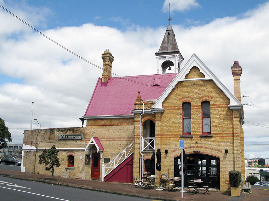
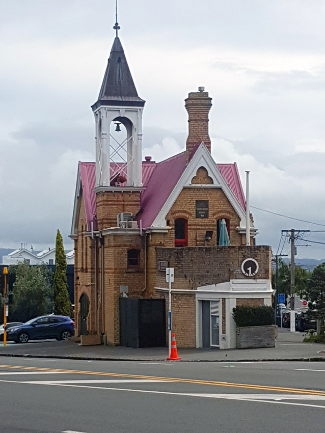
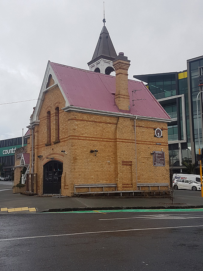
The former Council Chambers and Fire Station is located towards the eastern end of Grey Lynn, an inner suburb to the west of Auckland city centre. The building occupies a roughly triangular plot towards the eastern end of Williamson Avenue, near its intersection with Ponsonby Road. Both Williamson Avenue and Ponsonby Road are broad, busy thoroughfares. The 151m² lot occupies an unusual position, entirely surrounded by Rose Road, Pollen Street and Williamson Avenue. The site, just below the crest of Ponsonby ridge, slopes down to the west and is covered by the building and a small area of asphalt. A cluster of two-storey, nineteenth-century commercial buildings on the southeast corner of Williamson Avenue and Ponsonby Road provides a remnant of the historical streetscape into which the building was introduced in 1889. The prominent position and distinctive design of the building ensure that it is a local landmark. The late-Victorian building is strongly influenced by Free Gothic design, with steeply pitched roofs, decorated bargeboards, tall corbelled chimneys and an offset tower with open framing. Its walls are built of pale yellow brick, with horizontal banding of orange brick and several round-headed windows. The design combines the Gothic architecture of buildings such as churches and domestic dwellings with the more functional appearance of brick commercial structures in late nineteenth-century Auckland. The building has a corrugated iron roof. The building is comprised of two parts, the earliest of which is a two-storey structure of T-shaped plan at the western end of the plot, with a tower in one of its angles and an external staircase in another. A single-storey, wedge-shaped addition conjoins the earlier structure to the east, and now supports an open deck. When originally constructed, the ground floor of the building contained facilities for the local fire brigade, while the upper floor was reserved for use as council chambers. . The north and south facades of the building's western section are symmetrical. The west wall is without openings. Substantial arched doors open from the former fire appliance room at ground floor level onto Rose Road and Williamson Avenue. On the upper storey a pair of tall and narrow double-hung sash windows, in the north and south walls, light the former council chamber. There are similar windows on the building's east side, the southernmost of which has been modified to provide access onto a deck area on the roof of the addition. An entry porch at second-storey level on the building's north side provides a counterpoint to the bell tower on the south side. The ground floor (originally the fire station) is made up of three main areas: the former fire appliance room (now occupied by café tables); the central area (occupied by toilet facilities and the internal stairway); and the addition to the east (occupied by the restaurant kitchen). The upper floor (formerly the council chambers) is the main dining and reception area. Although the interior has been altered, some original features remain. A brick and concrete fire-hose-washing-trough extends the length of the western wall in the former fire appliance room. Cove ceilings on the upper floor are believed to be original. Replacement fire-surrounds and a grand staircase were introduced into the building when it was refurbished in the 1970s for use as a restaurant.
The former Council Chambers and Fire Station is located towards the eastern end of Grey Lynn, an inner suburb to the west of Auckland city centre. The building occupies a roughly triangular plot towards the eastern end of Williamson Avenue, near its intersection with Ponsonby Road. Both Williamson Avenue and Ponsonby Road are broad, busy thoroughfares. The 151m² lot occupies an unusual position, entirely surrounded by Rose Road, Pollen Street and Williamson Avenue. The site, just below the crest of Ponsonby ridge, slopes down to the west and is covered by the building and a small area of asphalt. A cluster of two-storey, nineteenth-century commercial buildings on the southeast corner of Williamson Avenue and Ponsonby Road provides a remnant of the historical streetscape into which the building was introduced in 1889. The prominent position and distinctive design of the building ensure that it is a local landmark. The late-Victorian building is strongly influenced by Free Gothic design, with steeply pitched roofs, decorated bargeboards, tall corbelled chimneys and an offset tower with open framing. Its walls are built of pale yellow brick, with horizontal banding of orange brick and several round-headed windows. The design combines the Gothic architecture of buildings such as churches and domestic dwellings with the more functional appearance of brick commercial structures in late nineteenth-century Auckland. The building has a corrugated iron roof. The building is comprised of two parts, the earliest of which is a two-storey structure of T-shaped plan at the western end of the plot, with a tower in one of its angles and an external staircase in another. A single-storey, wedge-shaped addition conjoins the earlier structure to the east, and now supports an open deck. When originally constructed, the ground floor of the building contained facilities for the local fire brigade, while the upper floor was reserved for use as council chambers. . The north and south facades of the building's western section are symmetrical. The west wall is without openings. Substantial arched doors open from the former fire appliance room at ground floor level onto Rose Road and Williamson Avenue. On the upper storey a pair of tall and narrow double-hung sash windows, in the north and south walls, light the former council chamber. There are similar windows on the building's east side, the southernmost of which has been modified to provide access onto a deck area on the roof of the addition. An entry porch at second-storey level on the building's north side provides a counterpoint to the bell tower on the south side. The ground floor (originally the fire station) is made up of three main areas: the former fire appliance room (now occupied by café tables); the central area (occupied by toilet facilities and the internal stairway); and the addition to the east (occupied by the restaurant kitchen). The upper floor (formerly the council chambers) is the main dining and reception area. Although the interior has been altered, some original features remain. A brick and concrete fire-hose-washing-trough extends the length of the western wall in the former fire appliance room. Cove ceilings on the upper floor are believed to be original. Replacement fire-surrounds and a grand staircase were introduced into the building when it was refurbished in the 1970s for use as a restaurant.
Historical and Associated Iwi / Hapū / Whānau
Information Sources
Auckland Architectural Association Bulletin
Auckland Architectural Association Bulletin
Bush, 1971
G .W. A. Bush, 'Decently and In Order: The Government of the City of Auckland 1840-1971', Auckland, 1971
Gillon, 1985
G.M. Gillon, United to Protect: An Historical Account of the Auckland Fire Brigade 1848-1985, Auckland, 1985.
Hiyama, 1991
Kaaren Hiyama, High Hopes in Hard Times: A History of Grey Lynn and Westmere, Auckland, 1991
New Zealand Herald
New Zealand Herald, 12 July 1932, p. 6; 28 September 1933, p. 6.
New Zealand Women's Weekly
New Zealand Women's Weekly
Auckland City Council
Auckland City Council
Other Information
A fully referenced version of this report is available from the NZHPT Northern Region Office. Please note that entry on the New Zealand Heritage List/Rarangi Korero identifies only the heritage values of the property concerned, and should not be construed as advice on the state of the property, or as a comment of its soundness or safety, including in regard to earthquake risk, safety in the event of fire, or insanitary conditions.
Current Usages
Uses: Trade
Specific Usage: Restaurant/cafe/tearoom
Former Usages
General Usage: Accommodation
Specific Usage: Complex of flats
General Usage: Government
Specific Usage: Council/local government building
General Usage: Trade
Specific Usage: Shop
General Usage: Utilities
Specific Usage: Fire Station
Location
Sign up to hear more
Get the latest heritage news, features and events delivered
straight to your inbox.
