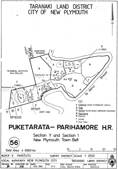
Te Ātiawa hapu occupied the area in and around what became New Plymouth for generations before European settlement began. Puketarata Pā is in a strategic location along Te Henui Stream and together with nearby Parihamore (Category 2 historic place, List No. 5969) and Pukewharangi Pā, these fortified settlements formed a defensive network in the late eighteenth century.
European settlement in New Plymouth began in earnest when New Zealand Company settlers arrived in 1841. The pā site was later surveyed as part of the Town Belt – an area which functioned as a transitional zone between the town and rural areas. The Scenery Preservation Act 1903 was New Zealand’s first legislation targeted at protecting historic sites. S. Percy Smith, a Taranaki local and Polynesian Society chair, was the Scenery Preservation Commission’s inaugural chair. In 1906 Puketarata Pā was among the first group of places formally protected by being made a scenic reserve under the Act and was fenced soon after to help ‘prevent its destruction’.
Smith described the pā in 1908 as ‘another excellent specimen of a fortified pa, still in good preservation’. In 1962 the site was said to feature ‘a hill with a single ditch and bank on all sides’. The discernible earthworks of this small ring ditch pā include perimeter ditches, terracing and pits. The platform is covered with vegetation.
The pā is a feature within Te Ara Puawai o Te Henui Walkway, a recreation route connecting aspects within the city’s Māori and early settler cultural and historic landscape, including Te Henui Vicarage, Category 1 historic place (List No. 892). In recognition of Puketarata Pā’s importance to iwi, under the terms of the 2014 Treaty of Waitangi Settlement an overlay classification was placed on the pā’s Historic Reserve which involves Te Ātiawa in the management of the site.
List Entry Information
Status
Listed
List Entry Status
Historic Place Category 2
Access
Private/No Public Access
List Number
5968
Date Entered
20th June 1985
Date of Effect
20th June 1985
City/District Council
New Plymouth District
Region
Taranaki Region
Extent of List Entry
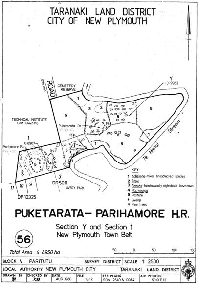
Sec Y New Plymouth Town Belt SO 2640 (RT TN59/80; NZ Gazette 1982, p.4253), Taranaki Land District Clarify extent: Extent includes the land described as Sec Y New Plymouth Town Belt SO 2640 (RT TN59/80; NZ Gazette 1982, p.4253), Taranaki Land District, and the archaeological site known as Puketarata Pā (NZAA P19/149) thereon, as shown on the location map appended to the notification letter dated 20 June 1985.
Legal description
Sec Y New Plymouth Town Belt SO 2640 (RT TN59/80; NZ Gazette 1982, p.4253), Taranaki Land District
Status
Listed
List Entry Status
Historic Place Category 2
Access
Private/No Public Access
List Number
5968
Date Entered
20th June 1985
Date of Effect
20th June 1985
City/District Council
New Plymouth District
Region
Taranaki Region
Extent of List Entry
Sec Y New Plymouth Town Belt SO 2640 (RT TN59/80; NZ Gazette 1982, p.4253), Taranaki Land District Clarify extent: Extent includes the land described as Sec Y New Plymouth Town Belt SO 2640 (RT TN59/80; NZ Gazette 1982, p.4253), Taranaki Land District, and the archaeological site known as Puketarata Pā (NZAA P19/149) thereon, as shown on the location map appended to the notification letter dated 20 June 1985.
Legal description
Sec Y New Plymouth Town Belt SO 2640 (RT TN59/80; NZ Gazette 1982, p.4253), Taranaki Land District
Construction Details
Type
Other
Description
Pā in use
Period
Eighteenth Century
Start Year
1906
startYearCirca
Type
Modification
Description
Pā fenced
Construction Details
Type
Other
Description
Pā in use
Period
Eighteenth Century
Start Year
1906
startYearCirca
Type
Modification
Description
Pā fenced
Historical and Associated Iwi / Hapū / Whānau
Public NZAA Number
P19/149
Completion Date
21st June 2017
Report Written By
Karen Astwood
Information Sources
Journal of the Polynesian Society
Journal of the Polynesian Society
NZHistory
‘Scenery Preservation Commission’, NZHistory (Ministry for Culture and Heritage), https://nzhistory.govt.nz/culture/scenery-preservation/scenery-preservation-commission, updated 20 Dec 2012.
Best, 1927
Best, Elsdon, ‘Puke-Tarata Pa’, The Pa Maori, Whitcombe and Tombs, Wellington, 1927, p.215, http://nzetc.victoria.ac.nz//tm/scholarly/tei-BesPaMa-t1-body-d5-d1-d11.html, accessed 12 Jun 2017.
Other Information
This place was identified as significant under previous legislation with different information requirements. It remains significant under the current legislation. There is opportunity under our legislation and policies to add to this information. Further information about this place may be available from the Central Regional Office of Heritage New Zealand Pouhere Taonga. Please note that entry on the New Zealand Heritage List/Rarangi Korero identifies only the heritage values of the property concerned, and should not be construed as advice on the state of the property, or as a comment of its soundness or safety, including in regard to earthquake risk, safety in the event of fire, or insanitary conditions. A fully referenced upgrade report is available on request from the Central Region Office of Heritage New Zealand.
Historical and Associated Iwi / Hapū / Whānau
Public NZAA Number
P19/149
Completion Date
21st June 2017
Report Written By
Karen Astwood
Information Sources
Journal of the Polynesian Society
Journal of the Polynesian Society
NZHistory
‘Scenery Preservation Commission’, NZHistory (Ministry for Culture and Heritage), https://nzhistory.govt.nz/culture/scenery-preservation/scenery-preservation-commission, updated 20 Dec 2012.
Best, 1927
Best, Elsdon, ‘Puke-Tarata Pa’, The Pa Maori, Whitcombe and Tombs, Wellington, 1927, p.215, http://nzetc.victoria.ac.nz//tm/scholarly/tei-BesPaMa-t1-body-d5-d1-d11.html, accessed 12 Jun 2017.
Other Information
This place was identified as significant under previous legislation with different information requirements. It remains significant under the current legislation. There is opportunity under our legislation and policies to add to this information. Further information about this place may be available from the Central Regional Office of Heritage New Zealand Pouhere Taonga. Please note that entry on the New Zealand Heritage List/Rarangi Korero identifies only the heritage values of the property concerned, and should not be construed as advice on the state of the property, or as a comment of its soundness or safety, including in regard to earthquake risk, safety in the event of fire, or insanitary conditions. A fully referenced upgrade report is available on request from the Central Region Office of Heritage New Zealand.
Current Usages
Uses: Civic Facilities
Specific Usage: Historic or recreation reserve
Former Usages
General Usage: Agriculture
Specific Usage: Paddock
General Usage: Maori
Specific Usage: Pā
Themes
Of Significance to Maori
Current Usages
Uses: Civic Facilities
Specific Usage: Historic or recreation reserve
Former Usages
General Usage: Agriculture
Specific Usage: Paddock
General Usage: Maori
Specific Usage: Pā
Themes
Of Significance to Maori