

The date of the initial construction and occupation of this site is not known, but by the early nineteenth century the pā was one of the key strongholds of the Taranaki Iwi. The site was besieged by a northern taua (war party), led by the important historical figures of Te Rauparaha (Ngāti Toa), Tu-whare (Ngā Puhi) and Muru-paenga (Ngāti Whatua) in 1818. Within the pā at that time were the important Taranaki figures of Kukutai, Te Ra-tu-tonu and Mounga-tu-kau, among others. The siege of the pā was ended when the defenders, with the aid of Te Atiawa members of the besieging taua, abandoned the pā under cover of darkness.
Tapuinukau also appears to have been reoccupied during the first Taranaki Land wars of 1860. However, the site was not attacked by the British.
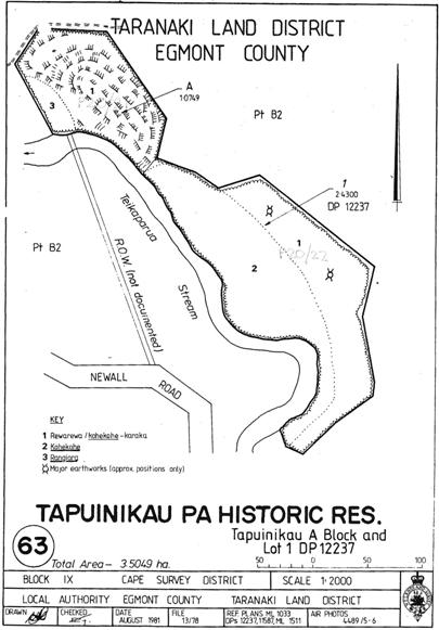
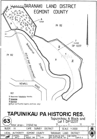
The pā consists of three hillocks formed by lahars, situated on the northern (right) bank of the Teikaparua (Warea) Stream. A series of concentric terraces surround the upper platforms of these mounds, which are naturally protected on the river flank by a steep drop to the river below. The three hillocks were formerly linked by an outer ditch and bank that enclosed them as a single site. Unfortunately these earthworks were levelled by bulldozing circa 1975. The pā contains numerous storage pits, levelled terraces and house platforms. Sections of stone revetments remain intact and widespread stone deposits on terraces point to more extensive revetments which have since deteriorated.
Tapuinikau was made a Scenic Reserve in 1929, however this area contained only the northernmost and largest of the lahars. It was then designated a Historic Reserve, and the smaller two lahars and an easement from Newall Road were added in 1976. The Taranaki Iwi Claims Settlement Act 2016 revoked the reservation and vested the estate in the trustees of Te Kahui o Taranaki. It is now a privately managed historic reserve.
Tapuinikau has been recorded as two archaeological sites in the New Zealand Archaeological Association (NZAA) site recording scheme. The NZAA site record postdates the bulldozing of the outer earthworks and the recorder was presumably unaware the hillocks were originally a larger, but singular, site. The northern and larger of the mounds is recorded as P20/21, while the smaller two mounds to the south are recorded as P20/22. In reality both sites are components of a single and much larger site.
Drainage of the Kiakia swamp, located immediately north of the pā, uncovered a number of carved wooden artefacts in 1976, now conserved and held at Puke Ariki. Photographic records also held at Puke Ariki show that the wetland was traversed by a wooden causeway. Further finds were uncovered from the same area in 1988; these are also conserved and held at Puke Ariki. Tapuinikau also contains a number of interesting and unusual features other than its archaeological record. Early records note that the site contains vegetation and natural features that have high cultural values to local Iwi.
Today the much of the site remains in excellent condition under the canopy of established bush. Despite the loss of the outer defensive earthworks the scarps and terraces are impressive and clusters of massive open storage pits, over 1.5 metres deep despite being half filled with leaf mould, are particularly notable on the upper platform of the northwest hillock. The site is an excellent field study of the resourceful adaptation of localised landforms into defensive pā sites by prehistoric Māori.
List Entry Information
Status
Listed
List Entry Status
Historic Place Category 2
Access
Private/No Public Access
List Number
5973
Date Entered
20th June 1985
Date of Effect
20th June 1985
City/District Council
South Taranaki District
Region
Taranaki Region
Extent of List Entry
Extent includes the land described as Tapuinikau A (RT TN13/90), Taranaki Land District and the archaeological site known as Tapuinikau Pā (NZAA site P20/21) thereon, as shown in the extent map tabled at the Rārangi Korēro Committee meeting on 26 April 2018.
Legal description
Tapuinikau A (RT TN13/90), Taranaki Land District
Status
Listed
List Entry Status
Historic Place Category 2
Access
Private/No Public Access
List Number
5973
Date Entered
20th June 1985
Date of Effect
20th June 1985
City/District Council
South Taranaki District
Region
Taranaki Region
Extent of List Entry
Extent includes the land described as Tapuinikau A (RT TN13/90), Taranaki Land District and the archaeological site known as Tapuinikau Pā (NZAA site P20/21) thereon, as shown in the extent map tabled at the Rārangi Korēro Committee meeting on 26 April 2018.
Legal description
Tapuinikau A (RT TN13/90), Taranaki Land District
Construction Details
Start Year
1975
Type
Damaged
Description
Outer ditch and bank levelled by bulldozing
Start Year
1976
Type
Modification
Description
Kiakia swamp drainage works uncovered archaeological features, including remnants of a wooden causeway and carved timber paepae
Start Year
1988
Type
Modification
Description
Further artefacts uncovered in the former Kiakia swamp area.
Construction Details
Start Year
1975
Type
Damaged
Description
Outer ditch and bank levelled by bulldozing
Start Year
1976
Type
Modification
Description
Kiakia swamp drainage works uncovered archaeological features, including remnants of a wooden causeway and carved timber paepae
Start Year
1988
Type
Modification
Description
Further artefacts uncovered in the former Kiakia swamp area.
Historical and Associated Iwi / Hapū / Whānau
Public NZAA Number
P20/21
Completion Date
4th April 2018
Report Written By
Ivan Bruce
Information Sources
Department of Conservation
Department of Conservation
Māori Wood Carving of the Taranaki Region
Day, K., Māori Wood Carving of the Taranaki Region, Reed Publishing, Auckland, 2001
History and Traditions of the Māoris on the West Coast North Island
Smith, S.P., History and Traditions of the Māoris on the West Coast North Island of New Zealand, prior to 1840, Thomas Avery, New Plymouth, 1910
Other Information
This place was identified as significant under previous legislation with different information requirements. It remains significant under the current legislation. There is opportunity under our legislation and policies to add to this information. Further information about this place may be available from the Central Regional Office of Heritage New Zealand Pouhere Taonga. Please note that entry on the New Zealand Heritage List/Rarangi Korero identifies only the heritage values of the property concerned, and should not be construed as advice on the state of the property, or as a comment of its soundness or safety, including in regard to earthquake risk, safety in the event of fire, or insanitary conditions. A fully referenced upgrade report is available on request from the Central Regional Office of Heritage New Zealand
Historical and Associated Iwi / Hapū / Whānau
Public NZAA Number
P20/21
Completion Date
4th April 2018
Report Written By
Ivan Bruce
Information Sources
Department of Conservation
Department of Conservation
Māori Wood Carving of the Taranaki Region
Day, K., Māori Wood Carving of the Taranaki Region, Reed Publishing, Auckland, 2001
History and Traditions of the Māoris on the West Coast North Island
Smith, S.P., History and Traditions of the Māoris on the West Coast North Island of New Zealand, prior to 1840, Thomas Avery, New Plymouth, 1910
Other Information
This place was identified as significant under previous legislation with different information requirements. It remains significant under the current legislation. There is opportunity under our legislation and policies to add to this information. Further information about this place may be available from the Central Regional Office of Heritage New Zealand Pouhere Taonga. Please note that entry on the New Zealand Heritage List/Rarangi Korero identifies only the heritage values of the property concerned, and should not be construed as advice on the state of the property, or as a comment of its soundness or safety, including in regard to earthquake risk, safety in the event of fire, or insanitary conditions. A fully referenced upgrade report is available on request from the Central Regional Office of Heritage New Zealand
Former Usages
General Usage: Civic Facilities
Specific Usage: Historic or recreation reserve
General Usage: Maori
Specific Usage: Ceremonial site
General Usage: Maori
Specific Usage: Pā
General Usage: Maori
Specific Usage: Pit
General Usage: Maori
Specific Usage: Terrace
General Usage: Maori
Specific Usage: Unspecified wāhi tapu area
General Usage: Maori
Specific Usage: Urupā
Themes
Of Significance to Maori
Former Usages
General Usage: Civic Facilities
Specific Usage: Historic or recreation reserve
General Usage: Maori
Specific Usage: Ceremonial site
General Usage: Maori
Specific Usage: Pā
General Usage: Maori
Specific Usage: Pit
General Usage: Maori
Specific Usage: Terrace
General Usage: Maori
Specific Usage: Unspecified wāhi tapu area
General Usage: Maori
Specific Usage: Urupā
Themes
Of Significance to Maori
Location
Sign up to hear more
Get the latest heritage news, features and events delivered
straight to your inbox.
