

Please note: NZHPT does not normally use the double 'a' or double 'u' that some people use when spelling Maori words, but the following report by S E Bulmer does and we have left it as is.
HISTORY OF MATUKURUA:
The proposed stonefield reserve consists of the last remaining segment of about 45 ha in the Matukurua volcanic fields. The area is south and west of McLaughlin's Mountain in Manukau City, a roughly triangular segment running from the base of the former cone. The fields were formerly about 500 ha in extent, surrounding Wiri and McLaughlin's Mountains, both of which supported terraced cone paa.
(N.B. This account has been prepared from published sources and has not yet been checked by Tangata whenua).
Matukurua ('the two bitterns' - Graham 1980:18) is the collective name for the two paa on the cones there, Matukutuureia (McLaughlin's Mount) and Matukutuururu (Wiri Mount). The traditional names come from George Graham, who recorded a text about the paa and the people who lived there (Graham 1925). The other name used to refer to these settlements is Puhinui ('the large eel' or the large plumes), the name of the streamlet partly encircling the fields.
From archaeological evidence, the settlement of Matukurua began at least by AD 1200 (Sullivan 1975), but probably much earlier. The volcanic lands and climate of Taamaki were among the best in the land. Some Maaori histories relating to the sites date to the 17th and 18th centuries, on genealogical grounds. A Tainui (Waikato) ancestor, Te Ata i Rehia, was a daughter of Huatau, a Waiohua chief of Matukutuureia paa in the 17th century (Graham 1925). The two paa were attacked by Kawharu, a chief of the Ngaati Whaatua of Kaipara, in about 1750 (Graham 1912). Takawai, a woman of Otaahuhu in the 17th century, married Huarangi, a chief of Puhinui (the name of the stream on the western and southern sides of the field), (Graham 1925:6). The Te Akitai people lived at Wiri (Matukurua), as well as at Puukaki and Otaahuhu in the late 18th and early 19th centuries.
Matukurua was probably unoccupied in the early 19th century, when Taamaki was generally vacated about 1820 in the path of musket raids from the north. Although the people returned to Auckland about 1835, apparently Matukurua was vacant at the time of the signing of the Treaty of Waitangi in 1840 and the land was sold as part of the Clendon Block in 1842, and re-sold to T.M. McLaughlin in 1845. Thereafter the land was used mainly for pastoral farming, and because its abundance of rocks prevented ploughing, the archaeological features are in a relatively good state of preservation.
Quarrying in the Matukurua field began on the eastern side, along the railway line, as early as the 1870s, although large scale quarrying at the McLaughlin's property, which included the proposed reserve area, only began in the 1960s. Six different quarries have destroyed all but 10% of the original fields. The proposed reserve area also includes the coastal peninsula, as well as a portion of Downers quarry, both of which are still used for pasture.
List Entry Information
Status
Listed
List Entry Status
Historic Place Category 2
Access
Private/No Public Access
List Number
6054
Date Entered
21st November 1991
Date of Effect
21st November 1991
City/District Council
Auckland Council
Region
Auckland Council
Legal description
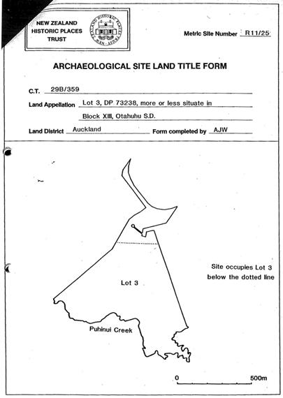
Lot 3 DP 73238 Blk XIII Otahuhu SD
Status
Listed
List Entry Status
Historic Place Category 2
Access
Private/No Public Access
List Number
6054
Date Entered
21st November 1991
Date of Effect
21st November 1991
City/District Council
Auckland Council
Region
Auckland Council
Legal description
Lot 3 DP 73238 Blk XIII Otahuhu SD
Historical and Associated Iwi / Hapū / Whānau
Public NZAA Number
R11/25
Information Sources
Auckland Institute & Museum
Auckland Institute & Museum
New Zealand Historic Places Trust (NZHPT)
New Zealand Historic Places Trust
University of Auckland
University of Auckland
Journal of the Polynesian Society
Journal of the Polynesian Society
Fenton, 1979
F D Fenton, Important Judgements Delivered in the Native Land Court, 1866-1879, Auckland, 1979
Searle, 1981
E J Searle 1981. City of Volcanoes. A geology of Auckland (Revised edition). Auckland , Longman Paul.
Tonson, 1966
A E Tonson, Old Manukau. Auckland, Tonson Publishing Co., 1966
Victoria University of Wellington
Victoria University of Wellington
Other Information
This place was identified as significant under previous legislation with different information requirements. It remains significant under the current legislation. There is opportunity under our legislation and policies to add to this information. Further information about this place may be available from the Northern Regional Office of Heritage New Zealand Pouhere Taonga. A copy of the original report is available from the NZHPT Northern region office Please note that entry on the New Zealand Heritage List/Rarangi Korero identifies only the heritage values of the property concerned, and should not be construed as advice on the state of the property, or as a comment of its soundness or safety, including in regard to earthquake risk, safety in the event of fire, or insanitary conditions.
Former Usages
General Usage: Ruin
Specific Usage: Misc Archaeological
Themes
Of Significance to Maori
Former Usages
General Usage: Ruin
Specific Usage: Misc Archaeological
Themes
Of Significance to Maori
Location
Sign up to hear more
Get the latest heritage news, features and events delivered
straight to your inbox.
