DonateSupporterVisit Heritage
  • Tūrangawaewae
    Places
  • Tira Māori
    Māori Heritage
  • Poutairangahia
    Archaeology
  • Rauemi
    Resources
  • Mō Tātou
    About Us
  • New Zealand Heritage List
  • Nominate and submit
  • Explore the List
  • National Historic Landmarks
  • Plaques
  • Rainbow List Project
  • Lost heritage
  • Visit Heritage
  • Our properties
  • Turnbull House Project
  • Collections
  • Shop
  • Tohu Whenua
  • Tira Māori
  • Conserving Māori heritage
  • Marae built heritage
  • Māori heritage on the List
  • Hinemihi—Te Hokinga Mai
  • What is archaeology?
  • Is there a site on my property?
  • What are my legal requirements?
  • Affecting an archaeological site
  • Declaring an archaeological site
  • Archaeology FAQs
  • Archaeology Digital Library
  • Archaeology guidelines and templates
  • Resources
  • Funding
  • Publications
  • Sustainable management guides
  • Disaster recovery
  • Podcasts & digital resources
  • Education Hub
  • Conservation plans
  • About
  • Board
  • Māori Heritage Council
  • Senior Staff
  • Offices
  • Contact us
  • Careers
  • Covenants
  • Fast-track
  • Corporate documents
  • Currently consulting on
  • Our submissions
  • News
Quick links
Rārangi Kōrero | The List
Explore the List
National Historic Landmarks
Ngā Manawhenua o Aotearoa me ōna Kōrero Tūturu
Quick links
Tapuwae
A Vision for Places of Māori Heritage
Funding for Māori Heritage
Resources
Quick links
Archaeological Authority Portal
Applying for an archaeological authority
Archaeology FAQs
Browse the most frequently asked questions about archaeological authorities and the archaeological process.
Quick links
Quick links
Contact us
Offices
DonateSupporterVisit Heritage
  • Tūrangawaewae
    Places
  • Tira Māori
    Māori Heritage
  • Poutairangahia
    Archaeology
  • Rauemi
    Resources
  • Mō Tātou
    About Us
  • New Zealand Heritage List
  • Nominate and submit
  • Explore the List
  • National Historic Landmarks
  • Plaques
  • Rainbow List Project
  • Lost heritage
  • Visit Heritage
  • Our properties
  • Turnbull House Project
  • Collections
  • Shop
  • Tohu Whenua
  • Tira Māori
  • Conserving Māori heritage
  • Marae built heritage
  • Māori heritage on the List
  • Hinemihi—Te Hokinga Mai
  • What is archaeology?
  • Is there a site on my property?
  • What are my legal requirements?
  • Affecting an archaeological site
  • Declaring an archaeological site
  • Archaeology FAQs
  • Archaeology Digital Library
  • Archaeology guidelines and templates
  • Resources
  • Funding
  • Publications
  • Sustainable management guides
  • Disaster recovery
  • Podcasts & digital resources
  • Education Hub
  • Conservation plans
  • About
  • Board
  • Māori Heritage Council
  • Senior Staff
  • Offices
  • Contact us
  • Careers
  • Covenants
  • Fast-track
  • Corporate documents
  • Currently consulting on
  • Our submissions
  • News
Quick links
Rārangi Kōrero | The List
Explore the List
National Historic Landmarks
Ngā Manawhenua o Aotearoa me ōna Kōrero Tūturu
Quick links
Tapuwae
A Vision for Places of Māori Heritage
Funding for Māori Heritage
Resources
Quick links
Archaeological Authority Portal
Applying for an archaeological authority
Archaeology FAQs
Browse the most frequently asked questions about archaeological authorities and the archaeological process.
Quick links
Quick links
Contact us
Offices
  • Places
  • Nominate and submit
  • National Historic Landmarks
  • Places
  • Nominate and submit
  • National Historic Landmarks
  • Tira Māori
  • Conserving Māori heritage
  • Marae built heritage
  • Tira Māori
  • Conserving Māori heritage
  • Marae built heritage
  • Archaeological authorities
  • Archaeology Digital Library
  • Archaeological authorities
  • Archaeology Digital Library
  • All resources
  • Publications
  • Funding
  • All resources
  • Publications
  • Funding
  • FAQs
  • FAQs
Follow us on:
Places
  • Places
  • Nominate and submit
  • National Historic Landmarks
Tira Māori
  • Tira Māori
  • Conserving Māori heritage
  • Marae built heritage
Archaeology
  • Archaeological authorities
  • Archaeology Digital Library
Resources
  • All resources
  • Publications
  • Funding
FAQs
  • FAQs
Follow us on
HomePrivacyTerms and conditionsAbout this site
© Heritage New Zealand Pouhere Taonga 2026.
 
Vulcan Lane Historic Area

Vulcan Lane, AUCKLAND

Public

Historic Area

List No. 7011

Quick links:
List GalleryLocationDetails
GENERAL DESCRIPTION:
Vulcan Lane has been shaped by its prominence as a busy pedestrian thoroughfare and place of social gathering, as well as its historical association with the growth of downtown Auckland.

Vulcan Lane first appeared in Felton Matthews' plan of Auckland in 1841 as a narrow service alley linking Queen and High Streets, and as an access lane to the merchant houses in Shortland Crescent (later Street). At this stage it was an unnamed and muddy track. In 1846 a smithy, named Vulcan Forge by its owner, was installed in the High St corner. By 1850 the name Vulcan Lane was in popular use, although it was never officially bestowed on the lane.

In the mid 1800s the largely pedestrian byway was an area of artisans' houses, workshops, grog shops and various merchants. A fire in 1850 destroyed much of the area, and redevelopment resulted in a shift of the commercial focus from the High St/Shortland Crescent area to Queen Street. During this stage Vulcan Lane developed a commercial character influenced by its strategic position between the old and new streets of commercial development.

During the 1860's the upper portion of the lane (between High and O'Connell Sts) opened but it was not considered a public street with public works. For example, the laying of a sewer in 1865 was confined to the lower portion of the lane. In general the whole length of the lane was in a poor and unformed condition.

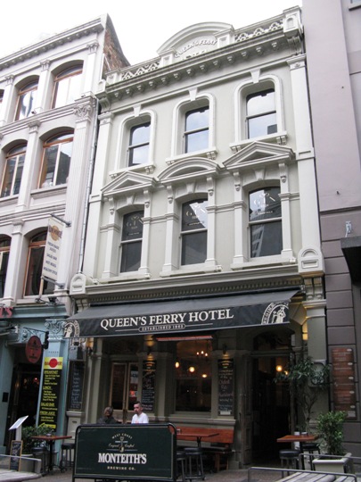
In 1865 a license was granted to the Queen's Ferry Hotel, and a substantial wholesale warehouse was opened in the lane. In 1870 the Occidental Hotel opened and a block of chambers was erected on the Queen St corner. This improved building continued through to 1875 by which time there was complaints of growing congestion in the lane.

Toward the end of the century (1890's), the overcrowded Vulcan Lane gained notoriety as a place of "evil population", but it also had premises for barristers, solicitors and other professionals with offices in the street. Vulcan Lane was now fully established in terms of its business nature.

In the 1920's the lane was widened by about 15ft on the south side, and new commercial buildings were being erected in the area. Any new buildings constructed in the lane had to conform with the Council's requirements and hence the lane adopted a wider more spacious and sunlit appearance.

In the next decade the commercial nature of Vulcan Lane flourished . However, after World War II motor traffic increased and buildings on the northern side of the lane began to show their age. There was less room for pedestrians and this resulted in a loss of attraction of the lane as a meeting place, so by the 1960's the lane became a pedestrian mall and was used for pedestrian traffic only. In recent years the mall has served as a gathering place for young people, for example, Auckland university students used the lane for classical busking in 1980 (subsequently banned a year later).

Vulcan Lane makes a significant contribution to Auckland's inner city in terms of its streetscape and character, and as a social drawcard. Vulcan Lane has been a popular thoroughfare in Auckland since the 1850s, constantly changing with the development of the city. The group of buildings within the area vary in age and architectural style but are similar in height and scale. The area has townscape and landmark qualities as well as great historical significance.
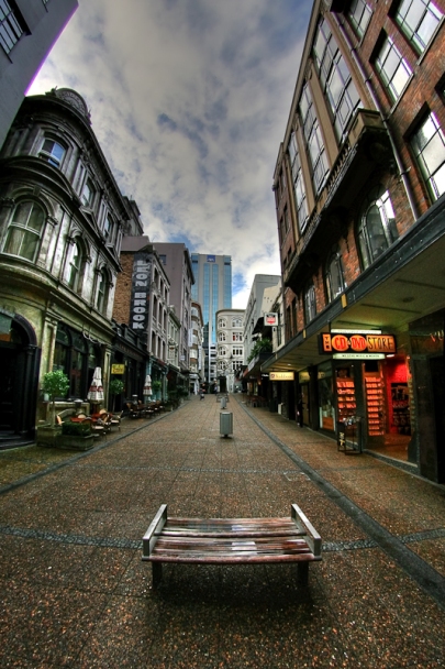
Vulcan Lane Historic Area. From: http://www.flickr.com/photos/craigsyd/3970560933/ | craigsyd - flickr | 24/07/2008 | craigsyd - flickr
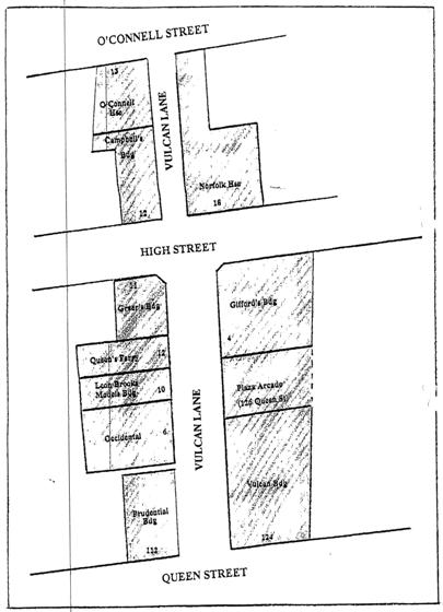
Plan of Historic Area from registration report. | 16/12/1994 | Heritage New Zealand Pouhere Taonga
Vulcan Lane Historic Area. From: http://www.flickr.com/photos/craigsyd/3970560933/ | craigsyd - flickr | 24/07/2008 | craigsyd - flickr
Plan of Historic Area from registration report. | 16/12/1994 | Heritage New Zealand Pouhere Taonga

List Entry Information

Overview

Status
Listed

List Entry Status
Historic Area

Access
Able to Visit

List Number
7011

Date Entered
16th December 1994

Date of Effect
16th December 1994

City/District Council
Auckland Council

Region
Auckland Council

Extent of List Entry

Buildings along each side of Vulcan Lane, from Queen St to High St (lower Vulcan Lane), and from High St to O'Connell St (upper Vulcan Lane).

Detailed List Entry
Significance

Cultural Significance

Cultural/Social: The lane has served as a pedestrian thoroughfare for over 120 years and has adapted to changes in commercial development of the city through to present day. The widening of the lane and City Council building restrictions in the 1920's transformed the atmosphere of the lane from a once disreputable area into a thriving commercial byway.

Historic Significance

Historical Significance or Value Vulcan Lane is historically significant as a prominent, busy pedestrian thoroughfare and place of social gathering as well as its associations with the growth of downtown Auckland city.

Physical Significance

Architectural: Vulcan Lane hosts a wide variety of architectural styles ranging from ornate Victorian facades through to more modern buildings. The commercial buildings of the 1920's and 30's are of a similar scale and height and are in direct contrast with the smaller scale hotels and low rise buildings on the lane's northern side. Aesthetic: Vulcan Lane makes a significant contribution to Auckland's inner city in terms of its streetscape and as a social meeting place. A unique atmosphere is promoted by its pedestrian nature and the surviving Victorian hotels suggest street life that existed during the mid to late nineteenth century. The variety of buildings enhance the lane's character and atmosphere and have prominent townscape and landmark qualities.

Physical Description

DESCRIPTION OF BOUNDARY: Vulcan Lane, from Queen Street to High Street (lower) and from High Street to O'Connell Street (upper).

Reference

Report Written By

Angela Smith

Report Written By

This historic place was registered under the Historic Places Act 1993. This report includes text from the original Proposal for Registration considered by the NZHPT Board at the time of registration. Please note that entry on the New Zealand Heritage List/Rarangi Korero identifies only the heritage values of the property concerned, and should not be construed as advice on the state of the property, or as a comment of its soundness or safety, including in regard to earthquake risk, safety in the event of fire, or insanitary conditions.

Further Information

Current Usages

Former Usages

General Usage:: Trade

Specific Usage: Shop

Themes

Web Links

Overview

Status

Listed

List Entry Status

Historic Area

Access

Able to Visit

List Number

7011

Date Entered

16th December 1994

Date of Effect

16th December 1994

City/District Council

Auckland Council

Region

Auckland Council

Extent of List Entry

Buildings along each side of Vulcan Lane, from Queen St to High St (lower Vulcan Lane), and from High St to O'Connell St (upper Vulcan Lane).

Status

Listed

List Entry Status

Historic Area

Access

Able to Visit

List Number

7011

Date Entered

16th December 1994

Date of Effect

16th December 1994

City/District Council

Auckland Council

Region

Auckland Council

Extent of List Entry

Buildings along each side of Vulcan Lane, from Queen St to High St (lower Vulcan Lane), and from High St to O'Connell St (upper Vulcan Lane).

Significance

Why is this place significant?

Cultural Significance

Cultural/Social: The lane has served as a pedestrian thoroughfare for over 120 years and has adapted to changes in commercial development of the city through to present day. The widening of the lane and City Council building restrictions in the 1920's transformed the atmosphere of the lane from a once disreputable area into a thriving commercial byway.

Historic Significance

Historical Significance or Value Vulcan Lane is historically significant as a prominent, busy pedestrian thoroughfare and place of social gathering as well as its associations with the growth of downtown Auckland city.

Physical Significance

Architectural: Vulcan Lane hosts a wide variety of architectural styles ranging from ornate Victorian facades through to more modern buildings. The commercial buildings of the 1920's and 30's are of a similar scale and height and are in direct contrast with the smaller scale hotels and low rise buildings on the lane's northern side. Aesthetic: Vulcan Lane makes a significant contribution to Auckland's inner city in terms of its streetscape and as a social meeting place. A unique atmosphere is promoted by its pedestrian nature and the surviving Victorian hotels suggest street life that existed during the mid to late nineteenth century. The variety of buildings enhance the lane's character and atmosphere and have prominent townscape and landmark qualities.

Why is this place significant?

Cultural Significance

Cultural/Social: The lane has served as a pedestrian thoroughfare for over 120 years and has adapted to changes in commercial development of the city through to present day. The widening of the lane and City Council building restrictions in the 1920's transformed the atmosphere of the lane from a once disreputable area into a thriving commercial byway.

Historic Significance

Historical Significance or Value Vulcan Lane is historically significant as a prominent, busy pedestrian thoroughfare and place of social gathering as well as its associations with the growth of downtown Auckland city.

Physical Significance

Architectural: Vulcan Lane hosts a wide variety of architectural styles ranging from ornate Victorian facades through to more modern buildings. The commercial buildings of the 1920's and 30's are of a similar scale and height and are in direct contrast with the smaller scale hotels and low rise buildings on the lane's northern side. Aesthetic: Vulcan Lane makes a significant contribution to Auckland's inner city in terms of its streetscape and as a social meeting place. A unique atmosphere is promoted by its pedestrian nature and the surviving Victorian hotels suggest street life that existed during the mid to late nineteenth century. The variety of buildings enhance the lane's character and atmosphere and have prominent townscape and landmark qualities.

Physical Description

DESCRIPTION OF BOUNDARY: Vulcan Lane, from Queen Street to High Street (lower) and from High Street to O'Connell Street (upper).

DESCRIPTION OF BOUNDARY: Vulcan Lane, from Queen Street to High Street (lower) and from High Street to O'Connell Street (upper).

Reference

Historical and Associated Iwi / Hapū / Whānau

Report Written By

Angela Smith

Other Information

This historic place was registered under the Historic Places Act 1993. This report includes text from the original Proposal for Registration considered by the NZHPT Board at the time of registration. Please note that entry on the New Zealand Heritage List/Rarangi Korero identifies only the heritage values of the property concerned, and should not be construed as advice on the state of the property, or as a comment of its soundness or safety, including in regard to earthquake risk, safety in the event of fire, or insanitary conditions.

Historical and Associated Iwi / Hapū / Whānau

Report Written By

Angela Smith

Other Information

This historic place was registered under the Historic Places Act 1993. This report includes text from the original Proposal for Registration considered by the NZHPT Board at the time of registration. Please note that entry on the New Zealand Heritage List/Rarangi Korero identifies only the heritage values of the property concerned, and should not be construed as advice on the state of the property, or as a comment of its soundness or safety, including in regard to earthquake risk, safety in the event of fire, or insanitary conditions.

Further Information

Former Usages

General Usage: Trade

Specific Usage: Shop

Former Usages

General Usage: Trade

Specific Usage: Shop

Location

Loading
Related listings
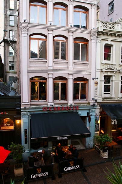
Cleave's Building (Former). From: http://www.flickr.com/photos/craigsyd/3913821320
Cleave's Building (Former)
Queen's Ferry Hotel
Queen's Ferry Hotel
Queen's Ferry Hotel
Queen's Ferry Hotel
Cleave's Building (Former). From: http://www.flickr.com/photos/craigsyd/3913821320
Cleave's Building (Former)
Sign up to hear more

Get the latest heritage news, features and events delivered
straight to your inbox.

Subscribe