

Early History
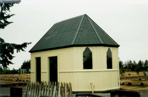
Te Wai Pounamu was occupied for centuries prior to the arrival of the first European colonial settlers. Ashburton was traditionally called Kāpuka. Situated along the Hakatere mahinga kai network that provided sustenance, tools and materials, Kāpuka supported the vibrant and successful pā dotted along the coastline which were thriving trade centres for a range of goods, including pounamu. In the 1840s early European explorers travelling through the Ashburton district closely followed the coastline but, as land was taken up by pastoralists, a better route across the plains soon evolved. This widely accepted route traversed the Ashburton River a few miles inland to avoid coastal swamps. Through the 1860s and 1870s a small township began to grow on the river’s north bank as the place became a frequent overnight stopping point and coach staging post. The town’s earlier cemetery was situated in the area of William Street and Kermode Street corner, now called Pioneer Park, but this closed in 1879. Around 1880 a new Ashburton Cemetery was established further to the north-east of the town, on the corner of Bremners Road and Seafield Road. A mortuary chapel, designed by Charles E. Fooks & Son, was erected there in 1884. In 1895, a timber Sexton’s Building was erected near the chapel, close to the Seafield Road - side of the cemetery. Designed with two separate rooms, the plans and specifications for the ‘office-tool house’ (Sexton’s Building) were drawn up by Charles Baker of Baker Bros. modestly reflecting the style of the cemetery’s existing larger and more ornate chapel. James Smith & Son, Builders & Contractors, were the successful tenderers, and they had constructed the timber building, complete with a shingle roof, by late 1895.
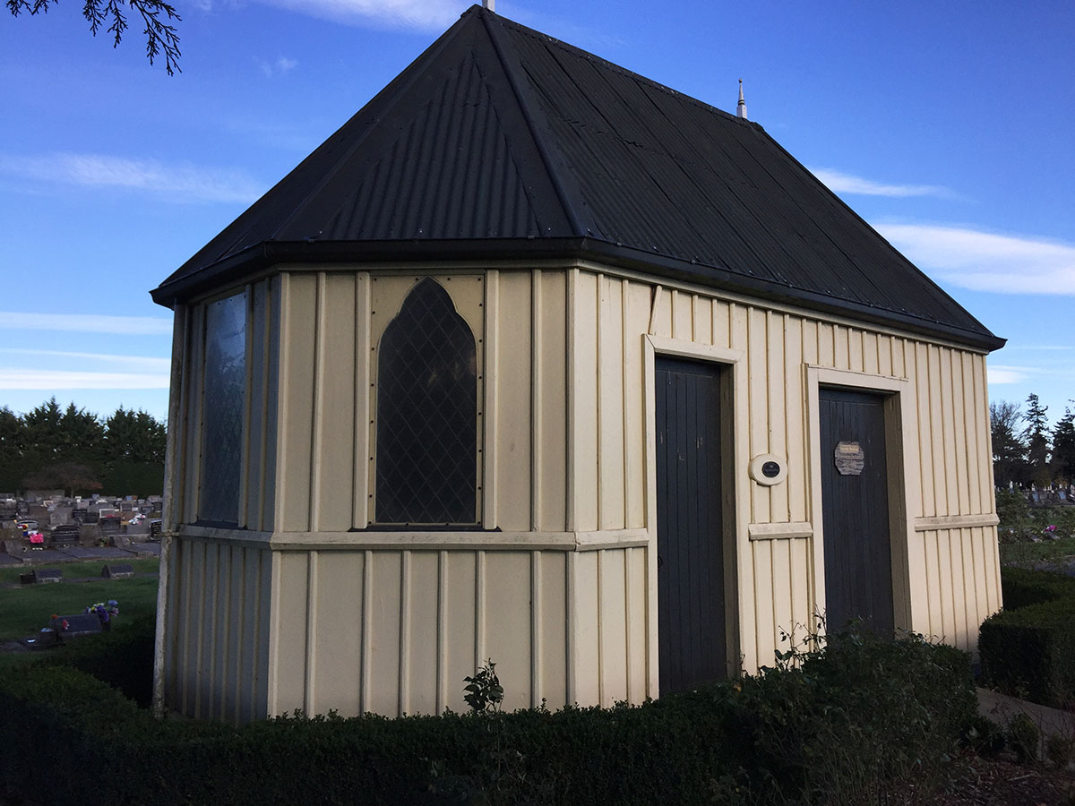
Now situated towards the north-eastern side of the cemetery, surrounding, the design of the Sexton Building is ecclesiastical in appearance, with a pitched roof, two long nave-like sides and apsidal ends. Windows are trefoil-headed – a common feature found in contemporary churches in Canterbury – with lead lights. Exterior timbers are board and batten, and the roof is clad in corrugated steel. Two doors on the north-west elevation provide access to two separate rooms within the building. On the interior, the earlier uses of the two separate parts of the building are still readable – the south-western was the workshop, having the larger space and a concrete floor and this steps up to the slightly smaller north-eastern room, with a timber floor, that had served as the Sexton’s office.
In 1947, Hughie Rainey used his traction engine to move the building to its present site to create more space for graves. At this time, its original shingle roof was replaced with iron, the floor of the work area was concreted, a second external door was added and an internal door blocked off. A desk from the chapel (which had been demolished in 1938) was adapted for the Sexton’s use. In the mid-1980s, once records and equipment were no longer kept in the building, it rapidly deteriorated. By 1994 there were large holes through the walls, badly broken windows and a rotted floor. ‘The Sexton’s Hut’ was at risk when the newly formed Ashburton District Branch of Historic Places Trust took up the challenge to save it from demolition. It was registered as a Category 2 historic place in 1996. Through community efforts, work carried out in the 1990s included restoration of the leadlight windows, structural repair, repainting, repiling, new concrete floor laid. In 1998 it was opened as an information centre. Further minor repairs and repainting was carried out in 2011 and again in 2020. A new replica main door was fitted in 2020, sound and self-closing, in time for the unveiling of Historic Places Mid Canterbury’s ceremony to unveil the building’s Heritage Blue Plaque on 22 November 2020.
List Entry Information
Status
Listed
List Entry Status
Historic Place Category 2
Access
Able to Visit
List Number
7305
Date Entered
16th February 1996
Date of Effect
16th February 1996
City/District Council
Ashburton District
Region
Canterbury Region
Extent of List Entry
Extent includes the part of the land described as Res 2283 Pt Res 1775 Blk XIII (NZ Gazette 1878, p. 483), Ashburton Survey District, and the building known as Sexton’s Building (Former) thereon. (Refer to Extent map tabled at the Rārangi Kōrero Committee meeting on 24 November 2021).
Legal description
Res 2283 Pt Res 1775 Blk XIII (NZ Gazette 1878, p.483), Ashburton Survey District
Location Description
Ashburton Cemetery
Construction Professional
Name
Charles Were Baker
Type
Architect
Biography
No biography is currently available for this construction professional
Name
James Smith & Frederick Smith
Type
Builder
Biography
No biography is currently available for this construction professional
Construction Details
Start Year
1947
Type
Relocation
Description
relocated towards north-eastern side of the cemetery
Type
Restoration
Description
repair and restoration, including repair of leadlights, new concrete floor, new external door.
Period
1990s
Start Year
1895
Type
Original Construction
Description
Sexton’s Building constructed
Historical and Associated Iwi / Hapū / Whānau
Other Information
A copy of the original report is available from the NZHPT Southern Region office Please note that entry on the New Zealand Heritage List/Rarangi Korero identifies only the heritage values of the property concerned, and should not be construed as advice on the state of the property, or as a comment of its soundness or safety, including in regard to earthquake risk, safety in the event of fire, or insanitary conditions.
Current Usages
Uses: Funerary Sites
Specific Usage: Funerary Site - other
Uses: Funerary Sites
Specific Usage: Sexton’s House/ Office
Current Usages
Uses: Funerary Sites
Specific Usage: Funerary Site - other
Uses: Funerary Sites
Specific Usage: Sexton’s House/ Office
Location
Sign up to hear more
Get the latest heritage news, features and events delivered
straight to your inbox.
