

The wider Papatoetoe area is a landscape where many iwi have overlaying interests and relationships. This region forms the narrowest part of the North Island. Tōanga waka or tōwaka (portages) between the Tāmaki River and Te Mānukanuka o Hoturoa (Manukau Harbour) connected the east and west coasts of the North Island. These routes and the associated pā which guarded them are important features of the Māori landscape of south Auckland. Archaeological remnants such as pā, middens, and stonefield horticultural landscapes show the area’s extensive ancestral footprint. The Papatoetoe area was densely populated and coveted for its fertile land, geographic attributes, and proximity to rich forest and marine resources.
The land was likely first alienated in Thomas Fairburn’s 1830s negotiations for a large portion of the Tāmaki Peninsula, but the excess was taken by the Crown in 1840. A segment was then granted to James Clendon. Clendon and subsequent owner William McLaughlin held extremely large properties, with the current site not being used for residential purposes until Norman McDonald purchased 176 acres in 1884. He likely built Cambria Park Homestead shortly after his purchase as the centrepiece of an arable and pastoral farm. In 1892 Edward Price purchased the property and developed the house as a part-time country residence until it became his primary residence circa 1912. Price operated a farm and racehorse stud, and later used the land to host Automobile Association of Auckland events. The Price family retained the property until the 1970s.
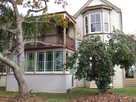
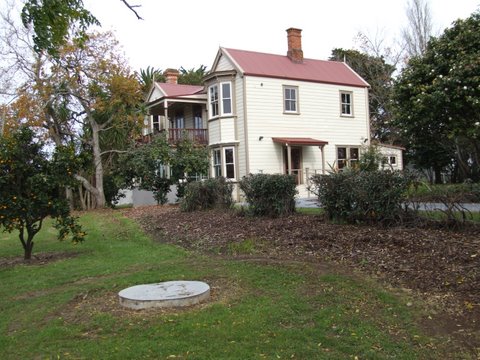
Cambria Park Homestead is a Victorian style two-storey symmetrical double bay residence, originally built from kauri beginning circa 1884. The first stage of construction included a two-bay villa with one and half storeys, incorporating seven rooms. The 1892 expansions added a two-storeyed wing and a full-sized billiard room on the ground floor. The dimensions of the billiard room may have given the south bay its wider form. A ground-story conservatory with a verandah above encloses the space between the two bays and serves as an entry. The Cambria Park Homestead comprises both the house and its garden setting, which includes award-winning camellias and mature trees, some planted in the early twentieth century. The area was planted with orchards prior to the house’s construction, and a fruit orchard is visible in front of the house in 1892 photos.
After 1892 Cambria Park Homestead remained an upper-class residence in a rural farming community. Later alterations include a small pantry addition to the brick scullery lean-to in 1924. As Papatoetoe grew, there were changes in the surrounding rural landscape, particularly after the Second World War (1939-45). In 1943, the majority of the Price family farmland was taken to develop a military camp to house U.S. servicemen stationed in Auckland. The Crown retained ownership of this land after the war and it was eventually zoned for industrial development. In 1962 a Nestlé factory was built south of the homestead and the rural nature of the area profoundly changed.
The Price family negotiated with the government to keep the homestead and immediate acreage when the rest of the farm was taken for military purposes. Camelia hedges, which appear mature and well-maintained in 1917 photos of the property, were continued and expanded through the mid-twentieth century. Additional orchard was added behind the house in 1948. Jack and Myra Price came to live in the homestead full time in 1958 and made changes to the bathrooms, kitchen and dining areas to modernize the home. They eventually sold the house and remaining homestead land in 1972 and it was rented to a series of tenants. The community esteem for the house, particularly in the 1990s, was considerable. The Cambria Park Homestead Steering Committee was formed in 1994 to help protect the place from demolition. Manukau City Council acquired the property in 1997 and restored it for reuse as offices.
List Entry Information
Status
Listed
List Entry Status
Historic Place Category 2
Access
Private/No Public Access
List Number
7351
Date Entered
25th October 1996
Date of Effect
25th October 1996
City/District Council
Auckland Council
Region
Auckland Council
Extent of List Entry
Extent includes the land described as Lot 1 DP 184348 (RT NA115A/753), North Auckland Land District, and the buildings, structures and mature plantings (including trees and camellias) known as Cambria Park Homestead thereon.
Legal description
Lot 1 DP 184348 (RT NA115A/753), North Auckland Land District
Why is this place significant?
Historic Significance
Historical Significance or Value This historic place was registered under the Historic Places Act 1993. The following text is from the original Recommendation for Registration considered by the NZHPT Board at the time of registration. Historical/Social: In 1879 N. McDonald built a house on the land and developed an orchard. From 1892 until 1942 it was owned and developed by E.A. Price, managing director of Auckland jewellery company, Buchanan & Co., who used Cambria Park as a residence and location for his hobby of horse breeding. In 1942 the land was requisitioned by the government to house some of the US forces based in Auckland. Since the war various parts of the land have been used for quarrying and for various industrial purposes. The homestead still remains and there is community interest regarding its future.
Physical Significance
This historic place was registered under the Historic Places Act 1993. The following text is from the original Recommendation for Registration considered by the NZHPT Board at the time of registration. Aesthetic: Cambria Park Homestead comprises both the house and its garden setting. The garden is well-known for its Camellias, planted in 1910, and mature trees. Architectural: The homestead is a large Victorian house built of kauri in 1879. The house is one of the oldest in Papatoetoe. The main (east) elevation reveals a symmetrical double bay villa, with two-storey bays flanking a central porch-verandah. The design of the rear elevation is plain. Archaeological: The site has been occupied since the 1870s and therefore has archaeological potential.
Why is this place Category 1 / Category 2?
Detail Of Assessed Criteria
This historic place was registered under the Historic Places Act 1993. The following text is from the original Recommendation for Registration considered by the NZHPT Board at the time of registration. The following comments are made in relation to the criteria identified under S.23(2) of the Historic Places Act 1993. b) The association of the place with events, persons or ideas of importance in New Zealand history: The American occupation of Cambria Park began in February 1943 when construction started on blocks of large kitchens and mess buildings, showers and latrines. Ten of these blocks served ten tented areas. The Public Works Department completed the whole complex within two months of receiving the request. The first troops arrived in Mid April. In total, 13 acres of land was levelled to serve 64 buildings and two miles of tarred roads. While this was impressive, it should be seen in context. Auckland hosted US armed forces personnel at Mechanics Bay, the Inner Domain, the Outer Domain, Victoria Park, Waikaraka Park, Tamaki, Mangere Crossing, Western Springs Motor Camp, Hobson Park, Cornwall Park, Avondale, Hillcrest, and Sylvia Park. The statistics for the US use of Auckland's spaces were impressive: By the end of 1943, something like 4,420 buildings of all types with an aggregate floor area of 1,113,316 square feet provided accommodation for approximately 29,500 men. In addition, the three hospitals at Hobson Park, Cornwall Park and, later, Avondale were able to house 4,500 patients in 251 buildings covering 1,005,000 square feet. There were 174 different store buildings with a total area of 1,733,467 square feet. The total number of buildings erected in the Auckland area for American forces was 4,965, covering a floor area of 3,939, 146 square feet. (Bevan) The history of Cambria Park is of interest to Papatoetoe and also has a representative value for the rest of Auckland. The transition from isolated rural settlement in the 1870s to semi-rural retreat and then incorporation into the larger metropolitan area after the Second World War illustrates the transformation of Auckland's rural fringe as urban development spread. e) The community association with, or public esteem for, the place: The community association with the house is considerable. The Cambria Park Homestead Steering Committee was formed in 1994 and various measures have been put in place to further consult the public regarding uses for the building, and to find ways and means to upgrade and preserve it. Conclusion: Cambria Park Homestead, 20 Puhinui Rd, Papatoetoe, Auckland, is recommended for registration as a Category II as a place of historical and cultural heritage significance and value. The large Victorian two storey bay villa was built in 1879. The house and garden have had various owners and uses over the years including the requisition of the land by the government in 1942 to house some of the US forces based in Auckland. The local community's interest in the building's future is considerable.
Construction Professional
Name
Matthews and Matthews Architects Limited
Type
Architectural Partnership
Biography
No biography is currently available for this construction professional
Name
Unknown
Type
Architect
Biography
No biography is currently available for this construction professional
Name
Unknown
Type
Builder
Biography
No biography is currently available for this construction professional
Construction Details
Start Year
1884
startYearCirca
Type
Original Construction
Description
Original construction of main residence.
Start Year
1892
startYearCirca
Type
Addition
Description
Major addition adding a second storey to the entire house
Start Year
1924
Type
Addition
Description
Small addition to northwest corner to form a pantry. Glasshouse and adjoining garage also built on property.
Start Year
1925
Type
Maintenance/repairs
Description
House connected to electricity.
Start Year
1879
Type
Original Construction
Start Year
1957
Finish Year
1958
Type
Modification
Description
Renovations including re-piling and bathroom upgrade - showerbox added to upstairs bathroom, toilet and hand basin installed in downstairs bathroom. Additional window added to dining room (formerly kitchen).
Start Year
2006
Type
Modification
Description
Renovations and refurbishment prior to Age Concern Counties Manukau occupation. Wheelchair access ramp added to exterior, property fenced, laundry converted to a washroom.
Historical and Associated Iwi / Hapū / Whānau
Public NZAA Number
R11/3217
Information Sources
Smytheman, 1962
Ivy F. Smytheman and Albert E. Tonson, Our First Hundred Years, A Historical Record of Papatoetoe, Papatoetoe, 1962.
Bevan, 1992
D Bevan, United States Forces in New Zealand 1942-1945 , Alexandra (1992)
Auckland Council
Auckland Council
New Zealand Herald
New Zealand Herald, ‘Historic Hut is Preserved’, 25 March 1961
Burgisser, 2006
Burgisser, Karl, ‘Arboricultural Assessment for Cambria Park 250 Puhinui Road Papatoetoe,’ report for Resource Consent Proposal 29166, Arborlab Consultancy Services, 2006.
Price, 2019
Price, Rodney, The Price Family, [New Zealand], 2019.
Other Information
A copy of the original report is available from the NZHPT Northern region office Please note that entry on the New Zealand Heritage List/Rarangi Korero identifies only the heritage values of the property concerned, and should not be construed as advice on the state of the property, or as a comment of its soundness or safety, including in regard to earthquake risk, safety in the event of fire, or insanitary conditions.
Current Usages
Uses: Accommodation
Specific Usage: House
Former Usages
General Usage: Accommodation
Specific Usage: House
Current Usages
Uses: Accommodation
Specific Usage: House
Former Usages
General Usage: Accommodation
Specific Usage: House
Location
Stay up to date with Heritage this month
