

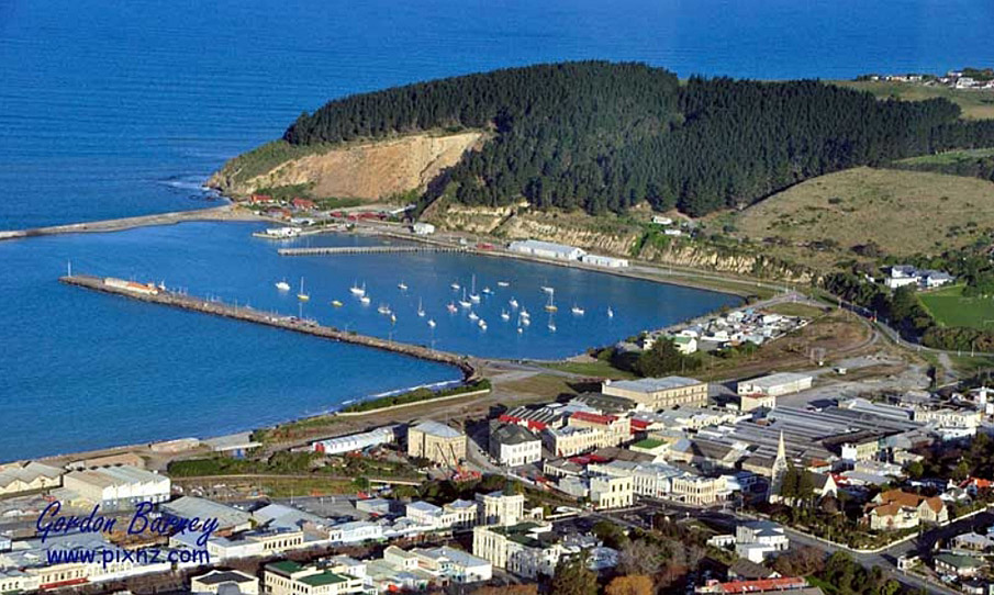
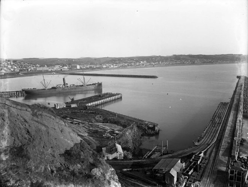
Until the completion of the first stage of the breakwater in the mid 1870s, Oamaru was notorious for the number of shipwrecks that took place there. Completion of the breakwater and Sumpter Wharf in 1884 enabled Oamaru to play a significant role in the new frozen meat trade. The port is associated with many famous early meat trade ships, including the Dunedin and the Elderslie, the first NZ-UK refrigerated steamer, built to run between Oamaru and London. Because the port closed to commercial shipping at the end of the conventional shipping era in 1974, it retains a unique assortment of heritage wharves, seawalls, sheds, rails and other features. The proposed Oamaru Harbour Historic Area provides vital physical and historical context for the already registered Oamaru Historic Area (7064). Oamaru's distinctive architectural character was based on wealth from the land, which found its local and export trade outlets through the port at Oamaru.
List Entry Information
Status
Listed
List Entry Status
Historic Area
Access
Private/No Public Access
List Number
7536
Date Entered
2nd April 2004
Date of Effect
2nd April 2004
City/District Council
Waitaki District
Region
Otago Region
Extent of List Entry
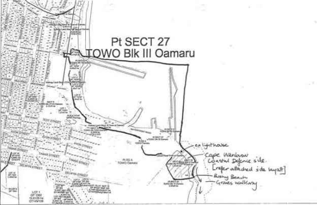
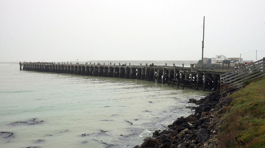
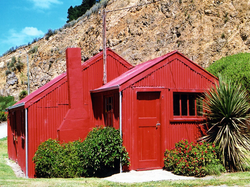
This historic area consists of an area of land that contains a group of inter-related historic places. The identified historic places that contribute to the values in this historic area are the Ōamaru Harbour Breakwater and Macandrew Wharf (Historic Place Category 1), the Former Harbour Board Quarry, Lighthouse, Cross Wharf (including attached chains and bollard at eastern end), Normanby Wharf (excluding the buildings on top of the wharf), Red Sheds, Robert & Betsy mast, Sumpter Wharf and associated wooden buildings, Harbour seawall (incl. chains fixed to the wall), Marine Parade (wall, lights & Coker memorial), Graves Walkway and tablet, Friendly Bay, Railway Footbridge, Holmes Wharf and associated buildings, Reclaimed land, Cape Wanbrow, White railing fence, Railway lines and archaeological features. The area of land that encompasses these historic places, includes the land described as Lot 1 DP 12415 (RT 482830), Lot 3 DP 18767 (RT 482826), Lot 4 DP 18767 (RT 482827), Lot 1 DP 406581 (RT 423117), Lot 2 DP 421926 (RT 696036), Lot 2 DP 422714 (No Title Seabed), Lots 1-2 DP 426950 (RT 1094827, 506032), Common Marine and Coastal Area (No Title Seabed), Lot 8 DP 487054 (RT 696032), Lot 9 DP 487054 (RT 696033), Lot 2 DP 489087 (RT 1117308, 702797), Lot 5 DP 489087 (RT 702799), Sec 11 SO 500094 (RT 814656, NZ Gazette 2017 ln 5786), Lots 8,11 DP 6515 (RT 1094827, 696037), Pt Sec 27 Block III Town of Oamaru (RT OT220/203), Sec 79 Block IV Oamaru SD (NZ Gazette 1986 p 1202), Sec 80 Block IV Oamaru SD (NZ Gazette 1986 p 308), Sec 1 SO 392126 (NZ Gazette 2007 p 2704 Amalgamated with land in CFR OTB1/773, RT 508521), Legal Road (NZ Gazette 2007 p 2704 Balance Road Parcel), Sec 1 SO 409544 (NZ Gazette 2008 p 5184), Sec 10 SO 500094 (NZ Gazette 2017 ln 5786, RT 814656), Secs 3-5 SO 500094 (NZ Gazette 2017 ln 5786), Sec 8 SO 500094 (NZ Gazette 2017 ln 5786, RT 814654), Legal Road, Otago Land District, and part of the land described as Lot 1 DP 421926 (No Title Seabed), Lot 1 DP 422714 (No Title Seabed), Lot 10 DP 487054 (No Title Road), Lot 2 DP 487054 (RT 814654), Lot 4 DP 531292 (RT 866587), Closed Road Town of Oamaru (RT OT17/157, Oamaru Harbour Board Land Oamaru Dock Trust Land Act 1872), Pt Res A Town of Oamaru (RT OT20/272, Oamaru Harbour Board Land Oamaru Dock Trust Land Act 1872), Sec 1 SO 24014 (NZ Gazette 1994 p 2292), Sec 9 SO 500094 (NZ Gazette 2017 ln 5786 Balance Gazette 1 July 1999, No 79, Page 1847, RT 814653), Legal Road, Otago Land District. Refer to the extent map tabled at the Rārangi Kōrero Committee meeting on 26 September 2024
Legal description
Lot 1 DP 12415 (RT 482830), Lot 3 DP 18767 (RT 482826), Lot 4 DP 18767 (RT 482827), Lot 1 DP 406581 (RT 423117), Lot 1 DP 421926 (No Title Seabed), Lot 2 DP 421926 (RT 696036), Lots 1-2 DP 422714 (No Title Seabed), Lots 1-2 DP 426950 (RT 1094827, 506032), Common Marine and Coastal Area (No Title Seabed), Lot 10 DP 487054 (No Title Road), Lot 2 DP 487054 (RT 814654), Lot 8 DP 487054 (RT 696032), Lot 9 DP 487054 (RT 696033), Lot 2 DP 489087 (RT 1117308, 702797), Lot 5 DP 489087 (RT 702799), Secs 10-11 SO 500094 (RT 814656, NZ Gazette 2017 ln 5786), Lot 4 DP 531292 (RT 866587), Lots 8,11 DP 6515 (RT 1094827, 696037), Closed Road Town of Oamaru (RT OT17/157, Oamaru Harbour Board Land Oamaru Dock Trust Land Act 1872), Pt Res A Town of Oamaru (RT OT20/272, Oamaru Harbour Board Land Oamaru Dock Trust Land Act 1872), Pt Sec 27 Block III Town of Oamaru (RT OT220/203), Sec 79 Block IV Oamaru SD (NZ Gazette 1986 p 1202), Sec 80 Block IV Oamaru SD (NZ Gazette 1986 p 308), Sec 1 SO 24014 (NZ Gazette 1994 p 2292), Sec 1 SO 392126 (NZ Gazette 2007 p 2704 Amalgamated with land in CFR OTB1/773, RT 508521), Legal Road (NZ Gazette 2007 p 2704 Balance Road Parcel), Sec 1 SO 409544 (NZ Gazette 2008 p 5184), Secs 3-5 SO 500094 (NZ Gazette 2017 ln 5786), Sec 8 SO 500094 (NZ Gazette 2017 ln 5786, RT 814654), Sec 9 SO 500094 (NZ Gazette 2017 ln 5786 Balance Gazette 1 July 1999, No 79, Page 1847, RT 814653), Sec 10 SO 500094 (NZ Gazette 2017 ln 5786, RT 814656), Legal Road, Otago Land District
Status
Listed
List Entry Status
Historic Area
Access
Private/No Public Access
List Number
7536
Date Entered
2nd April 2004
Date of Effect
2nd April 2004
City/District Council
Waitaki District
Region
Otago Region
Extent of List Entry
This historic area consists of an area of land that contains a group of inter-related historic places. The identified historic places that contribute to the values in this historic area are the Ōamaru Harbour Breakwater and Macandrew Wharf (Historic Place Category 1), the Former Harbour Board Quarry, Lighthouse, Cross Wharf (including attached chains and bollard at eastern end), Normanby Wharf (excluding the buildings on top of the wharf), Red Sheds, Robert & Betsy mast, Sumpter Wharf and associated wooden buildings, Harbour seawall (incl. chains fixed to the wall), Marine Parade (wall, lights & Coker memorial), Graves Walkway and tablet, Friendly Bay, Railway Footbridge, Holmes Wharf and associated buildings, Reclaimed land, Cape Wanbrow, White railing fence, Railway lines and archaeological features. The area of land that encompasses these historic places, includes the land described as Lot 1 DP 12415 (RT 482830), Lot 3 DP 18767 (RT 482826), Lot 4 DP 18767 (RT 482827), Lot 1 DP 406581 (RT 423117), Lot 2 DP 421926 (RT 696036), Lot 2 DP 422714 (No Title Seabed), Lots 1-2 DP 426950 (RT 1094827, 506032), Common Marine and Coastal Area (No Title Seabed), Lot 8 DP 487054 (RT 696032), Lot 9 DP 487054 (RT 696033), Lot 2 DP 489087 (RT 1117308, 702797), Lot 5 DP 489087 (RT 702799), Sec 11 SO 500094 (RT 814656, NZ Gazette 2017 ln 5786), Lots 8,11 DP 6515 (RT 1094827, 696037), Pt Sec 27 Block III Town of Oamaru (RT OT220/203), Sec 79 Block IV Oamaru SD (NZ Gazette 1986 p 1202), Sec 80 Block IV Oamaru SD (NZ Gazette 1986 p 308), Sec 1 SO 392126 (NZ Gazette 2007 p 2704 Amalgamated with land in CFR OTB1/773, RT 508521), Legal Road (NZ Gazette 2007 p 2704 Balance Road Parcel), Sec 1 SO 409544 (NZ Gazette 2008 p 5184), Sec 10 SO 500094 (NZ Gazette 2017 ln 5786, RT 814656), Secs 3-5 SO 500094 (NZ Gazette 2017 ln 5786), Sec 8 SO 500094 (NZ Gazette 2017 ln 5786, RT 814654), Legal Road, Otago Land District, and part of the land described as Lot 1 DP 421926 (No Title Seabed), Lot 1 DP 422714 (No Title Seabed), Lot 10 DP 487054 (No Title Road), Lot 2 DP 487054 (RT 814654), Lot 4 DP 531292 (RT 866587), Closed Road Town of Oamaru (RT OT17/157, Oamaru Harbour Board Land Oamaru Dock Trust Land Act 1872), Pt Res A Town of Oamaru (RT OT20/272, Oamaru Harbour Board Land Oamaru Dock Trust Land Act 1872), Sec 1 SO 24014 (NZ Gazette 1994 p 2292), Sec 9 SO 500094 (NZ Gazette 2017 ln 5786 Balance Gazette 1 July 1999, No 79, Page 1847, RT 814653), Legal Road, Otago Land District. Refer to the extent map tabled at the Rārangi Kōrero Committee meeting on 26 September 2024
Legal description
Lot 1 DP 12415 (RT 482830), Lot 3 DP 18767 (RT 482826), Lot 4 DP 18767 (RT 482827), Lot 1 DP 406581 (RT 423117), Lot 1 DP 421926 (No Title Seabed), Lot 2 DP 421926 (RT 696036), Lots 1-2 DP 422714 (No Title Seabed), Lots 1-2 DP 426950 (RT 1094827, 506032), Common Marine and Coastal Area (No Title Seabed), Lot 10 DP 487054 (No Title Road), Lot 2 DP 487054 (RT 814654), Lot 8 DP 487054 (RT 696032), Lot 9 DP 487054 (RT 696033), Lot 2 DP 489087 (RT 1117308, 702797), Lot 5 DP 489087 (RT 702799), Secs 10-11 SO 500094 (RT 814656, NZ Gazette 2017 ln 5786), Lot 4 DP 531292 (RT 866587), Lots 8,11 DP 6515 (RT 1094827, 696037), Closed Road Town of Oamaru (RT OT17/157, Oamaru Harbour Board Land Oamaru Dock Trust Land Act 1872), Pt Res A Town of Oamaru (RT OT20/272, Oamaru Harbour Board Land Oamaru Dock Trust Land Act 1872), Pt Sec 27 Block III Town of Oamaru (RT OT220/203), Sec 79 Block IV Oamaru SD (NZ Gazette 1986 p 1202), Sec 80 Block IV Oamaru SD (NZ Gazette 1986 p 308), Sec 1 SO 24014 (NZ Gazette 1994 p 2292), Sec 1 SO 392126 (NZ Gazette 2007 p 2704 Amalgamated with land in CFR OTB1/773, RT 508521), Legal Road (NZ Gazette 2007 p 2704 Balance Road Parcel), Sec 1 SO 409544 (NZ Gazette 2008 p 5184), Secs 3-5 SO 500094 (NZ Gazette 2017 ln 5786), Sec 8 SO 500094 (NZ Gazette 2017 ln 5786, RT 814654), Sec 9 SO 500094 (NZ Gazette 2017 ln 5786 Balance Gazette 1 July 1999, No 79, Page 1847, RT 814653), Sec 10 SO 500094 (NZ Gazette 2017 ln 5786, RT 814656), Legal Road, Otago Land District
Why is this place significant?
Cultural Significance
Oamaru Harbour has considerable social and cultural value. It is widely used for recreation. A number of recreational and sporting groups - the Oamaru Rowing Club, the North Otago Yacht and Power Boat Club and Scott's Own Sea Scouts, amongst others - have used the harbour for many decades; Oamaru's distinction in rowing history, including the gold medal Perth Commonwealth Games coxed four in 1962, and Olympics success of the 1968 Eight, owes much to training on this harbour. More recently, the harbour has hosted a traditional boats day each March and a steam train links the town to the port area, where the Red Sheds are now the base for traditional crafts activities. In addition to these organised activities, the harbour has also played an important role in passive recreation; walking, sightseeing, recreational fishing from the wharves, and swimming and paddling at Friendly Bay and by the breakwater beach are just some of the activities undertaken here. Noted author Janet Frame remembers in her autobiographies fishing with her father on Holmes Wharf, and visiting Friendly Bay at Christmas time. The harbour and Friendly Bay also appear in her fictional work. Requests in 2002 for the return of toilet facilities to Friendly Bay demonstrate community esteem for the area.
Historic Significance
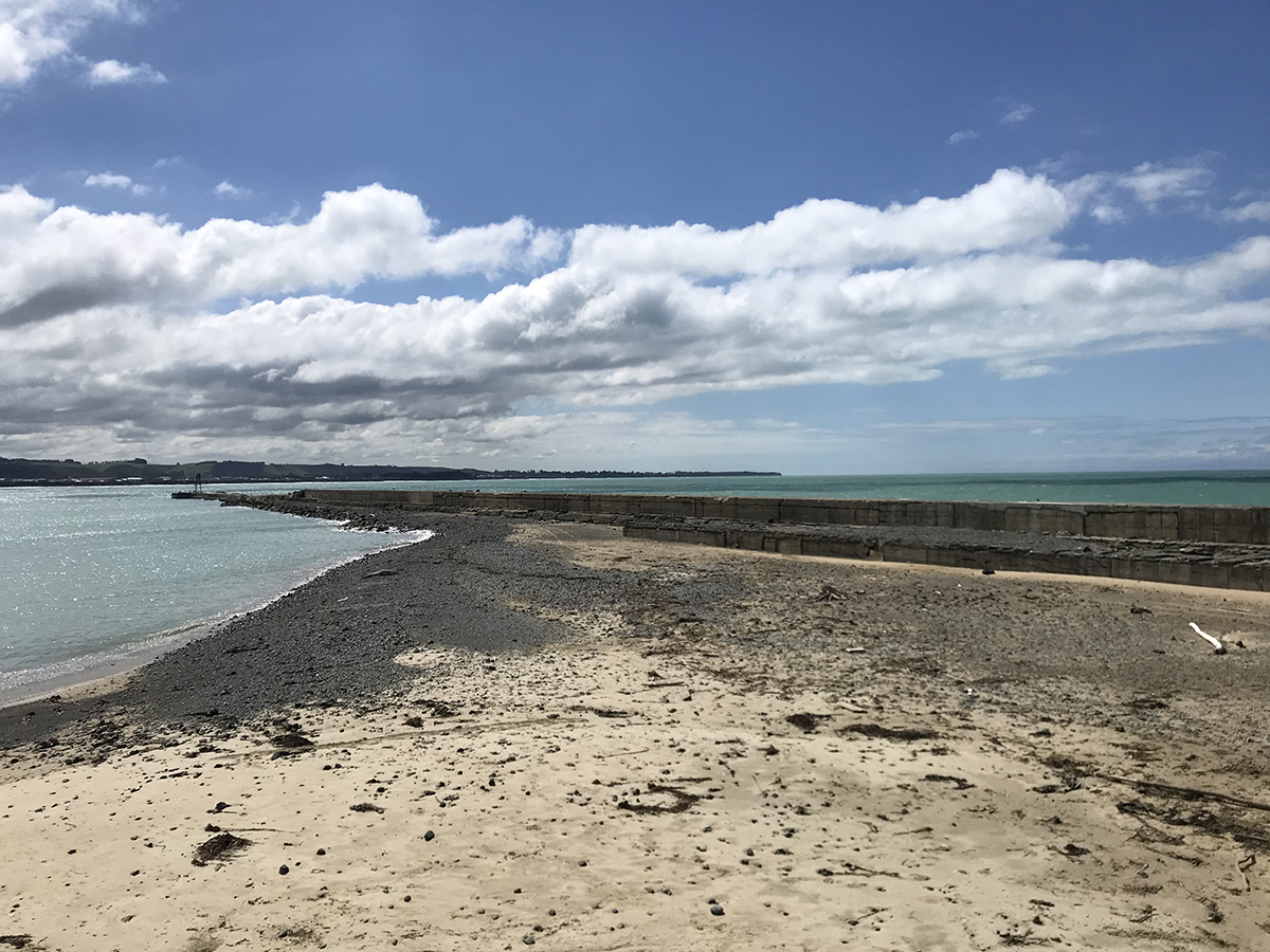
Historical Significance or Value Oamaru Harbour is New Zealand's only surviving authentic Victorian/Edwardian deepwater port, paralleling the town's uniquely intact colonial architectural inheritance. In colonial New Zealand, ports underpinned the local and regional economy, and Oamaru's harbour, constructed in defiance of natural limitations and at great cost, exemplifies the extent to which communities took 'pride in their ports'. Until the completion of the first stage of the breakwater in the mid 1870s, Oamaru was notorious for the number of shipwrecks that took place there. Completion of the breakwater and Sumpter Wharf in 1884 enabled Oamaru to play a significant role in the new frozen meat trade. The port is associated with many famous early meat trade ships, including the Dunedin and the Elderslie, the first NZ-UK refrigerated steamer, built to run between Oamaru and London. Because the port closed to commercial shipping at the end of the conventional shipping era in 1974, it retains a unique assortment of heritage wharves, seawalls, sheds, rails and other features. The harbour is associated with people, entities and events of international, national and local significance. Internationally, it has strong links to the pioneering days of the frozen meat trade. The meat trade pioneer, the ship Dunedin, sailed from Oamaru several times and went missing between Oamaru and London some time in 1890. Oamaru exported North Otago produce during the South African and the First and Second World Wars. It is associated with NZ-UK shipping lines such as Shaw Savill & Albion, the New Zealand Shipping Company, Port Line and the Blue Star Line, amongst others. In the early hours of 10 February 1913 the Antarctic expedition ship Terra Nova appeared off the port, lowered a boat and sent two officers ashore to cable the news of the death of Captain Scott and his colleagues. As K. C. McDonald wrote, this event caused 'the name of Oamaru to be read if not remembered throughout the world'. The harbour also played an important part in the national history. Oamaru was once one of New Zealand's more dangerous ports, claiming over 25 shipwrecks, and several lives in the great storm of February 1868. The port is associated with the Union Steam Ship Company, Holm Shipping, Canterbury Steam Shipping and the Northern Company, amongst other coastal and trans-Tasman shipping lines. The harbour's historical significance has been detailed by Gavin McLean in 100 Historic Places in New Zealand (Hodder Moa Beckett, Auckland, 2002, pp. 87-89) and in Oamaru: History & Heritage (University of Otago Press, Dunedin, 2002, pp 9-10. and pp 50-52). Its historical importance is also well-attested by other historians. K. C. McDonald's Whitestone Country shows the dependence of the town and hinterland on the port. In Landmarks, the TV series and book of 1981, Kenneth Cumberland highlighted Oamaru as the archetypal 'Kiwitown' and emphasised the importance of the port to the town (Reader's Digest, Auckland, 1981, pp. 256-257) In A History of Otago, Erik Olssen (John McIndoe, Dunedin, 1984, p. 78) stresses the importance of the port to the town's development. More recently, in Paradise Reclaimed, (Penguin, Auckland, 2001, p. 523), the second volume of his history of New Zealand, James Belich also notes Oamaru's role as what he calls a 'protein port'.
Physical Significance
Most of the harbour area is an archaeological site in terms of Part I of the Historic Places Act. Historic rail lines, bollards and traces of stone curbing in the ground suggest that the reclaimed land is worth surveying. There may also be evidence on the seafloor, since beaches and water edges are often areas where material is lost or disposed of. The wharves, walls and buildings have architectural and engineering value. That of the breakwater has already been attested by its registration as a Category II historic place. The other wharves and seawalls demonstrate late nineteenth century engineering technology. The Red Sheds and the wharf sheds at the end of Sumpter Wharf are fine examples of vernacular architecture. The area's aesthetic value is reflected in it being a popular subject for painters and photographers. The buildings, structures and steam crane are widely admired and the sea and seacliffs have considerable aesthetic value. While there are two other harbour-side historic areas registered with the Trust (740: Harbour Historic Area, Auckland, and 7036: Harbour and Wharves Historic Area, Wellington), there are no representative examples of the smaller coastal and international ports or harbours. Oamaru Harbour-side Area is an intact example of a Victorian deep water port in a regional centre. The proposed Oamaru Harbour Historic Area has a vital association with the already registered nearby Harbour/Tyne Street Historic Area (7064). The proposed Historic Area is the physical and historical context for the already registered Historic Area.. The booming meat, wool and grain trade from the harbour underpins the economic prosperity of Oamaru in the late nineteenth century which resulted in the development of its distinctive architecture.
Why is this place significant?
Cultural Significance
Oamaru Harbour has considerable social and cultural value. It is widely used for recreation. A number of recreational and sporting groups - the Oamaru Rowing Club, the North Otago Yacht and Power Boat Club and Scott's Own Sea Scouts, amongst others - have used the harbour for many decades; Oamaru's distinction in rowing history, including the gold medal Perth Commonwealth Games coxed four in 1962, and Olympics success of the 1968 Eight, owes much to training on this harbour. More recently, the harbour has hosted a traditional boats day each March and a steam train links the town to the port area, where the Red Sheds are now the base for traditional crafts activities. In addition to these organised activities, the harbour has also played an important role in passive recreation; walking, sightseeing, recreational fishing from the wharves, and swimming and paddling at Friendly Bay and by the breakwater beach are just some of the activities undertaken here. Noted author Janet Frame remembers in her autobiographies fishing with her father on Holmes Wharf, and visiting Friendly Bay at Christmas time. The harbour and Friendly Bay also appear in her fictional work. Requests in 2002 for the return of toilet facilities to Friendly Bay demonstrate community esteem for the area.
Historic Significance
Historical Significance or Value Oamaru Harbour is New Zealand's only surviving authentic Victorian/Edwardian deepwater port, paralleling the town's uniquely intact colonial architectural inheritance. In colonial New Zealand, ports underpinned the local and regional economy, and Oamaru's harbour, constructed in defiance of natural limitations and at great cost, exemplifies the extent to which communities took 'pride in their ports'. Until the completion of the first stage of the breakwater in the mid 1870s, Oamaru was notorious for the number of shipwrecks that took place there. Completion of the breakwater and Sumpter Wharf in 1884 enabled Oamaru to play a significant role in the new frozen meat trade. The port is associated with many famous early meat trade ships, including the Dunedin and the Elderslie, the first NZ-UK refrigerated steamer, built to run between Oamaru and London. Because the port closed to commercial shipping at the end of the conventional shipping era in 1974, it retains a unique assortment of heritage wharves, seawalls, sheds, rails and other features. The harbour is associated with people, entities and events of international, national and local significance. Internationally, it has strong links to the pioneering days of the frozen meat trade. The meat trade pioneer, the ship Dunedin, sailed from Oamaru several times and went missing between Oamaru and London some time in 1890. Oamaru exported North Otago produce during the South African and the First and Second World Wars. It is associated with NZ-UK shipping lines such as Shaw Savill & Albion, the New Zealand Shipping Company, Port Line and the Blue Star Line, amongst others. In the early hours of 10 February 1913 the Antarctic expedition ship Terra Nova appeared off the port, lowered a boat and sent two officers ashore to cable the news of the death of Captain Scott and his colleagues. As K. C. McDonald wrote, this event caused 'the name of Oamaru to be read if not remembered throughout the world'. The harbour also played an important part in the national history. Oamaru was once one of New Zealand's more dangerous ports, claiming over 25 shipwrecks, and several lives in the great storm of February 1868. The port is associated with the Union Steam Ship Company, Holm Shipping, Canterbury Steam Shipping and the Northern Company, amongst other coastal and trans-Tasman shipping lines. The harbour's historical significance has been detailed by Gavin McLean in 100 Historic Places in New Zealand (Hodder Moa Beckett, Auckland, 2002, pp. 87-89) and in Oamaru: History & Heritage (University of Otago Press, Dunedin, 2002, pp 9-10. and pp 50-52). Its historical importance is also well-attested by other historians. K. C. McDonald's Whitestone Country shows the dependence of the town and hinterland on the port. In Landmarks, the TV series and book of 1981, Kenneth Cumberland highlighted Oamaru as the archetypal 'Kiwitown' and emphasised the importance of the port to the town (Reader's Digest, Auckland, 1981, pp. 256-257) In A History of Otago, Erik Olssen (John McIndoe, Dunedin, 1984, p. 78) stresses the importance of the port to the town's development. More recently, in Paradise Reclaimed, (Penguin, Auckland, 2001, p. 523), the second volume of his history of New Zealand, James Belich also notes Oamaru's role as what he calls a 'protein port'.
Physical Significance
Most of the harbour area is an archaeological site in terms of Part I of the Historic Places Act. Historic rail lines, bollards and traces of stone curbing in the ground suggest that the reclaimed land is worth surveying. There may also be evidence on the seafloor, since beaches and water edges are often areas where material is lost or disposed of. The wharves, walls and buildings have architectural and engineering value. That of the breakwater has already been attested by its registration as a Category II historic place. The other wharves and seawalls demonstrate late nineteenth century engineering technology. The Red Sheds and the wharf sheds at the end of Sumpter Wharf are fine examples of vernacular architecture. The area's aesthetic value is reflected in it being a popular subject for painters and photographers. The buildings, structures and steam crane are widely admired and the sea and seacliffs have considerable aesthetic value. While there are two other harbour-side historic areas registered with the Trust (740: Harbour Historic Area, Auckland, and 7036: Harbour and Wharves Historic Area, Wellington), there are no representative examples of the smaller coastal and international ports or harbours. Oamaru Harbour-side Area is an intact example of a Victorian deep water port in a regional centre. The proposed Oamaru Harbour Historic Area has a vital association with the already registered nearby Harbour/Tyne Street Historic Area (7064). The proposed Historic Area is the physical and historical context for the already registered Historic Area.. The booming meat, wool and grain trade from the harbour underpins the economic prosperity of Oamaru in the late nineteenth century which resulted in the development of its distinctive architecture.
Construction Details
Start Year
1909
Finish Year
1909
Type
Original Construction
Description
Railway Footbridge
Construction Details
Start Year
1909
Finish Year
1909
Type
Original Construction
Description
Railway Footbridge
The first European trading vessel is believed to have worked Oamaru's open roadstead in 1854. At that time there was no township, merely a sheep station. The coast was desolate and rough: To the right was the bare hump of Cape Wanbrow, with the sea dashing against the rocks at its foot, for there was then no intervening shelf of flat land. On the left, the low hills were broken by a deep gully before turning north in a long, even wall which edged gradually further from the sea as it marched northwards. Between this rampart and the shore was a narrow strip of plain stretching north to a flat horizon and broken off abruptly at the sea-edge. The sheep station, and the growing number of settlers loaded and unloaded their cargoes in the surf, with Moeraki Maori playing a prominent part in the difficult, dangerous work. By the late 1850s Oamaru had gained a landing service, with the Provincial Government providing a derrick for hoisting goods from the top of the bank near the landing. A goods store was built and the Maori workers accommodated in whare on the beach. Service was slow and expensive, but allowed Oamaru to develop into a small settlement. It would boom from the early 1860s as a goldfields servicing centre and a supply town for a prosperous wool and grain growing region. The town's coastline was very exposed. Cape Wanbrow offered some protection from southerly storms but the beach was open to northerlies and very dangerous. Many North Otago residents questioned the sense of using the place, but it was declared a port of entry in 1861. By 1863 there were both inner and outer moorings available, but it was still a dangerous site for ships and insurance firms refused to cover ships anchoring at Oamaru at the normal rate. The foundation stone of Oamaru's first jetty was laid in December 1865 and in 1867 an L-shaped jetty had been completed in the lee of Cape Wanbrow but it was too exposed to be satisfactory. That jetty was destroyed in February 1868, when a deep storm also wrecked two overseas wool ships, the Star of Tasmania and Water Nymph and the coaster Otago. Later that month Oamaru residents observed a day of humiliation and fasting, something the Oamaru Times considered less useful than a collection. The disaster of February 1868 forced provincial authorities to re-examine their plans and the Oamaru Dock Trust was established in 1869, and active until 1874. The grant to the Dock Trust was for the "improvement of the Harbour of Oamaru and the construction and maintenance of such Dock's piers and other Works thereon as may be deemed advisable" by the superintendent of Otago "for facilitating the trade and commerce of the said Town and Port of Oamaru." The initial plan was for an enclosed dock in the lagoon of the Oamaru Creek (which then took a more meandering route to the sea) but this was amended to a deepwater breakwater port instead, following plans drawn up by Scottish harbour engineer John McGregor in 1871. These plans included the construction of a breakwater near the site of the original jetty, under Cape Wanbrow and a mole on the northern side to form a smooth water basin. Work began on the breakwater in 1871 and progressed slowly. In 1874 the Oamaru Harbour Board replaced the old Dock Trust and later that year a statute vested 171 acres of land in the Board. This consisted mostly of the bay itself but included a strip of land covering the harbour railway. The land originally granted to the Dock Trust includes the land between the what is now the east side of Tyne Street and the sea. This block is a major part of the Harbour/ Tyne Street Historic Area, where the buildings are linked to the Port functions, particularly the warehouses. The port's safety improved long before the breakwater was completed. In 1875 the first wharf, a concrete structure alongside the breakwater, was opened in 1875. Macandrew Wharf, as the 50-metre wharf was known, was opened on 6 May. By 1876 the wharf was 110 metres long, offering two berths and an average depth alongside of four to five metres. More wharves followed. Normanby Wharf, another concrete wharf, offering berthage on three sides, was finished in 1878 and the Cross Wharf, a short concrete breastwork wharf located between Normanby and Macandrew, was ready by 1879. Normanby could handle ships of 2 000 tons. By the end of 1879 the 380 metres of berth age could accommodate six to seven vessels, enabling the boating service to be discontinued. It was the discovery, however, by board secretary Thomas Forrester (1838-1907) in 1878 that the seabed was merely compacted shell and sand and not rock that was the making of the Port of Oamaru. This spurred a major expansion programme in 1883, centred around the purchase of a steam dredge, the Progress, and the construction of an export pier, Sumpter Wharf. By the end of 1884 Oamaru had stolen a march over rivals such as Otago and Timaru. Sumpter Wharf offered a depth of seven metres and the Elderslie, the first steamer for the New Zealand-United Kingdom meat trade, was visiting the town; that vessel was intended to trade exclusively between Oamaru and London. The Oamaru Harbour Board completed the breakwater early in 1884, when Miller & Smilie placed the last 300-tonne monolith in place. The final structure was 564 metres long, 11 metres wide and 9.8 metres high. About the same time the 493 metre-long rock mole was complete to the north. By then the board had over-reached itself financially. Storm damage to the breakwater in 1886 merely compounded its financial problems as it struggled to service interest payments. In 1894 it went into receivership, three years after defaulting on interest payments. Like most ports, Oamaru's business rose and fell according to the health of the economy. From the 1890s the port's traffic increased and in 1907 the board, still in receivership, opened its largest wharf, Holmes Wharf, on the mole. This kept Oamaru in the export trade and in 1909 the board's loans were consolidated and the receiver was stood down. In 1913 Oamaru Harbour was secretly visited by the Terra Nova, Captain Robert Falcon Scott's ship, bearing news of the death of Scott and his companions during their expedition to reach the South Pole. Contemporary newspaper reports said that the Terra Nova arrived in Oamaru around 2 am on Monday 10 February. She was warned off by the night watchman and responded by signalling she was sending a boat ashore. The boat was directed to Sumpter Wharf and two of the four men landed, Lieutenant Penn ell and Mr Atkinson. They would not inform the night watchman which ship they were from but instead contacted the harbourmaster, Captain Ramsay, from the night watchman's office. Ramsay put up the officers overnight, after which they caught the train to Christchurch, having telegraphed news of Scott's death from Oamaru. As K. C. McDonald wrote, this event caused 'the name of Oamaru to be read if not remembered throughout the world'. There was a short recession in 1921 but in general the interwar period was a good one for the port, which was visited by larger ships (the Onawa and Ontario, each of about 10,100 tons, called in the late 1930s). In 1928 Holmes Wharf was lengthened to accommodate these ships. In 1936 the Harbour Board began its final big construction programme, an extension to the breakwater. The Ramsay Extension (as it was named), was angled out to provide sheltered water for a dredged channel out to deeper water. But the work, which depended on subsidised relief labour, proceeded slowly and was 'capped' in December 1944, short of even its revised target length; in any case, the last UK trade freighter had called in 1940. Gradually the extension broke up. During World War II a battery was constructed on Cape Wanbrow to protect the harbour from enemy attack. After the Japanese attack on Pearl Harbour in December 1941, New Zealand made a concerted effort to provide defences for its secondary ports, as well as the major ones. The battery at Cape Wanbrow consisted of a camp for the service personnel, a gun emplacement which housed a former United States Navy 5-inch gun, a magazine and a battery observation post. A machine gun pit, located further south along the coast, provided protection for the battery from any attack from the south. The gun was never fired at enemy ships and was removed to Burnham Military Camp in 1945. The camp huts and mess/kitchen were also removed from the site. Despite the loss of overseas shipping, the port's trade generally increased in the late 1950s and the early 1960s before coastal shipping began to lose trade share to rail and road transport. At the beginning of 1966 the Customs Department closed its Oamaru office and Oamaru Harbour ceased to be a port of entry. In 1970-1971 Oamaru was used by overseas ships servicing the Sedco oil rig off the coast. In 1973-1974 a few small Tongan ships also called to load frozen meat, but these did not developed into sustainable business. In 1973 the last trans-Tasman ship, the Koraki, called. In 1974 the last coaster, the Holmdale, took away the last cargo. In 1975 the Chair of Board announced that no cargo-moving vessels had entered the port in the last 12 months and therefore Oamaru had ceased to function as a port. The Harbour Board celebrated its centenary in 1974 but four years later it would be abolished and replaced by a Harbour Committee made up of representatives from the local borough councils. Within a few years New Zealand Cement Holdings was planning to re-open the port. It received the necessary approvals from the New Zealand Ports Authority and sketches called for the construction of a 10,000-tonne capacity silo behind Friendly Bay, a loading berth on Holmes Wharf and the demolition of Sumpter Wharf to improve the swinging basin, but the investment was never made. Since then the harbour has served a handful of inshore fishing vessels and recreational craft. The oil industry's tanks and pipelines have been removed and the harbour has become more of a tourist-oriented place. In the 1990s a blue penguin-viewing colony was established near the end of the breakwater and artisans and steam train enthusiasts have a base here too. Oamaru Harbour has also always been used for recreational activities. The first regatta was held on 25 May 1885 to celebrate the 66th birthday of Queen Victoria and included both sailing and rowing races. It proved to be very popular, with music from the Oamaru Garrison Band. A further regatta was held in 1910 and between then and 1947 other regattas were occasionally held. The harbour also proved suitable for rowing. In 1895 the Union Rowing Club erected a landing stage to enable boats to be launched more easily (as the reclamation meant the sloping shingle was disappearing. (OM 23/12/1895)The Oamaru Boating Club was established in 1919. Friendly Bay, the small sandy beach created in the northwest corner of the harbour became Oamaru's beach with circuses playing on the foreshore from the 1890s and annual carnivals held between Christmas and New Year's from the 1920s. Fishing off the wharves was also popular as was at one time trolling for flounder. The local Beautifying Society, formed in 1908, (such societies a feature of late nineteenth/early twentieth century New Zealand society) approached the Harbour Board in 1912, asking for assistance to create a picnic and beach area. The Society was proposing to roof in the old concrete mixing shed and also to install a fireplace and seating in the old quarry area. Until the 1970s Oamaru Harbour was one of the country's major seaports. Its heyday was the late 1870s and early 1880s when trade flourished. With the economic depression of the 1880s, and the development of rail links and more sophisticated port facilities in Dunedin and Timaru trade from the Oamaru slowly declined. This decline has contributed to the character of both the harbour and the town, creating aspects of townscape and harbourscape relatively untouched by more modern developments. As Gavin MacLean has noted its story is one of struggle and not without controversy. It was a facility fought for and valued by its community, through financial difficulties, economic depression as well as calmer times. The success of the port made an enormous contribution to the development of the province, providing an export port for the grain, wool and meat which made up a substantial part of the export trade from Oamaru. The character of Oamaru, particularly the commercial area next to the harbour, is founded on the Port - the grain stores, harbour board office, the, merchants, customs building and banks - all these surviving historic buildings represent an economic vitality provided by the Port of Oamaru which shaped the town itself.
The first European trading vessel is believed to have worked Oamaru's open roadstead in 1854. At that time there was no township, merely a sheep station. The coast was desolate and rough: To the right was the bare hump of Cape Wanbrow, with the sea dashing against the rocks at its foot, for there was then no intervening shelf of flat land. On the left, the low hills were broken by a deep gully before turning north in a long, even wall which edged gradually further from the sea as it marched northwards. Between this rampart and the shore was a narrow strip of plain stretching north to a flat horizon and broken off abruptly at the sea-edge. The sheep station, and the growing number of settlers loaded and unloaded their cargoes in the surf, with Moeraki Maori playing a prominent part in the difficult, dangerous work. By the late 1850s Oamaru had gained a landing service, with the Provincial Government providing a derrick for hoisting goods from the top of the bank near the landing. A goods store was built and the Maori workers accommodated in whare on the beach. Service was slow and expensive, but allowed Oamaru to develop into a small settlement. It would boom from the early 1860s as a goldfields servicing centre and a supply town for a prosperous wool and grain growing region. The town's coastline was very exposed. Cape Wanbrow offered some protection from southerly storms but the beach was open to northerlies and very dangerous. Many North Otago residents questioned the sense of using the place, but it was declared a port of entry in 1861. By 1863 there were both inner and outer moorings available, but it was still a dangerous site for ships and insurance firms refused to cover ships anchoring at Oamaru at the normal rate. The foundation stone of Oamaru's first jetty was laid in December 1865 and in 1867 an L-shaped jetty had been completed in the lee of Cape Wanbrow but it was too exposed to be satisfactory. That jetty was destroyed in February 1868, when a deep storm also wrecked two overseas wool ships, the Star of Tasmania and Water Nymph and the coaster Otago. Later that month Oamaru residents observed a day of humiliation and fasting, something the Oamaru Times considered less useful than a collection. The disaster of February 1868 forced provincial authorities to re-examine their plans and the Oamaru Dock Trust was established in 1869, and active until 1874. The grant to the Dock Trust was for the "improvement of the Harbour of Oamaru and the construction and maintenance of such Dock's piers and other Works thereon as may be deemed advisable" by the superintendent of Otago "for facilitating the trade and commerce of the said Town and Port of Oamaru." The initial plan was for an enclosed dock in the lagoon of the Oamaru Creek (which then took a more meandering route to the sea) but this was amended to a deepwater breakwater port instead, following plans drawn up by Scottish harbour engineer John McGregor in 1871. These plans included the construction of a breakwater near the site of the original jetty, under Cape Wanbrow and a mole on the northern side to form a smooth water basin. Work began on the breakwater in 1871 and progressed slowly. In 1874 the Oamaru Harbour Board replaced the old Dock Trust and later that year a statute vested 171 acres of land in the Board. This consisted mostly of the bay itself but included a strip of land covering the harbour railway. The land originally granted to the Dock Trust includes the land between the what is now the east side of Tyne Street and the sea. This block is a major part of the Harbour/ Tyne Street Historic Area, where the buildings are linked to the Port functions, particularly the warehouses. The port's safety improved long before the breakwater was completed. In 1875 the first wharf, a concrete structure alongside the breakwater, was opened in 1875. Macandrew Wharf, as the 50-metre wharf was known, was opened on 6 May. By 1876 the wharf was 110 metres long, offering two berths and an average depth alongside of four to five metres. More wharves followed. Normanby Wharf, another concrete wharf, offering berthage on three sides, was finished in 1878 and the Cross Wharf, a short concrete breastwork wharf located between Normanby and Macandrew, was ready by 1879. Normanby could handle ships of 2 000 tons. By the end of 1879 the 380 metres of berth age could accommodate six to seven vessels, enabling the boating service to be discontinued. It was the discovery, however, by board secretary Thomas Forrester (1838-1907) in 1878 that the seabed was merely compacted shell and sand and not rock that was the making of the Port of Oamaru. This spurred a major expansion programme in 1883, centred around the purchase of a steam dredge, the Progress, and the construction of an export pier, Sumpter Wharf. By the end of 1884 Oamaru had stolen a march over rivals such as Otago and Timaru. Sumpter Wharf offered a depth of seven metres and the Elderslie, the first steamer for the New Zealand-United Kingdom meat trade, was visiting the town; that vessel was intended to trade exclusively between Oamaru and London. The Oamaru Harbour Board completed the breakwater early in 1884, when Miller & Smilie placed the last 300-tonne monolith in place. The final structure was 564 metres long, 11 metres wide and 9.8 metres high. About the same time the 493 metre-long rock mole was complete to the north. By then the board had over-reached itself financially. Storm damage to the breakwater in 1886 merely compounded its financial problems as it struggled to service interest payments. In 1894 it went into receivership, three years after defaulting on interest payments. Like most ports, Oamaru's business rose and fell according to the health of the economy. From the 1890s the port's traffic increased and in 1907 the board, still in receivership, opened its largest wharf, Holmes Wharf, on the mole. This kept Oamaru in the export trade and in 1909 the board's loans were consolidated and the receiver was stood down. In 1913 Oamaru Harbour was secretly visited by the Terra Nova, Captain Robert Falcon Scott's ship, bearing news of the death of Scott and his companions during their expedition to reach the South Pole. Contemporary newspaper reports said that the Terra Nova arrived in Oamaru around 2 am on Monday 10 February. She was warned off by the night watchman and responded by signalling she was sending a boat ashore. The boat was directed to Sumpter Wharf and two of the four men landed, Lieutenant Penn ell and Mr Atkinson. They would not inform the night watchman which ship they were from but instead contacted the harbourmaster, Captain Ramsay, from the night watchman's office. Ramsay put up the officers overnight, after which they caught the train to Christchurch, having telegraphed news of Scott's death from Oamaru. As K. C. McDonald wrote, this event caused 'the name of Oamaru to be read if not remembered throughout the world'. There was a short recession in 1921 but in general the interwar period was a good one for the port, which was visited by larger ships (the Onawa and Ontario, each of about 10,100 tons, called in the late 1930s). In 1928 Holmes Wharf was lengthened to accommodate these ships. In 1936 the Harbour Board began its final big construction programme, an extension to the breakwater. The Ramsay Extension (as it was named), was angled out to provide sheltered water for a dredged channel out to deeper water. But the work, which depended on subsidised relief labour, proceeded slowly and was 'capped' in December 1944, short of even its revised target length; in any case, the last UK trade freighter had called in 1940. Gradually the extension broke up. During World War II a battery was constructed on Cape Wanbrow to protect the harbour from enemy attack. After the Japanese attack on Pearl Harbour in December 1941, New Zealand made a concerted effort to provide defences for its secondary ports, as well as the major ones. The battery at Cape Wanbrow consisted of a camp for the service personnel, a gun emplacement which housed a former United States Navy 5-inch gun, a magazine and a battery observation post. A machine gun pit, located further south along the coast, provided protection for the battery from any attack from the south. The gun was never fired at enemy ships and was removed to Burnham Military Camp in 1945. The camp huts and mess/kitchen were also removed from the site. Despite the loss of overseas shipping, the port's trade generally increased in the late 1950s and the early 1960s before coastal shipping began to lose trade share to rail and road transport. At the beginning of 1966 the Customs Department closed its Oamaru office and Oamaru Harbour ceased to be a port of entry. In 1970-1971 Oamaru was used by overseas ships servicing the Sedco oil rig off the coast. In 1973-1974 a few small Tongan ships also called to load frozen meat, but these did not developed into sustainable business. In 1973 the last trans-Tasman ship, the Koraki, called. In 1974 the last coaster, the Holmdale, took away the last cargo. In 1975 the Chair of Board announced that no cargo-moving vessels had entered the port in the last 12 months and therefore Oamaru had ceased to function as a port. The Harbour Board celebrated its centenary in 1974 but four years later it would be abolished and replaced by a Harbour Committee made up of representatives from the local borough councils. Within a few years New Zealand Cement Holdings was planning to re-open the port. It received the necessary approvals from the New Zealand Ports Authority and sketches called for the construction of a 10,000-tonne capacity silo behind Friendly Bay, a loading berth on Holmes Wharf and the demolition of Sumpter Wharf to improve the swinging basin, but the investment was never made. Since then the harbour has served a handful of inshore fishing vessels and recreational craft. The oil industry's tanks and pipelines have been removed and the harbour has become more of a tourist-oriented place. In the 1990s a blue penguin-viewing colony was established near the end of the breakwater and artisans and steam train enthusiasts have a base here too. Oamaru Harbour has also always been used for recreational activities. The first regatta was held on 25 May 1885 to celebrate the 66th birthday of Queen Victoria and included both sailing and rowing races. It proved to be very popular, with music from the Oamaru Garrison Band. A further regatta was held in 1910 and between then and 1947 other regattas were occasionally held. The harbour also proved suitable for rowing. In 1895 the Union Rowing Club erected a landing stage to enable boats to be launched more easily (as the reclamation meant the sloping shingle was disappearing. (OM 23/12/1895)The Oamaru Boating Club was established in 1919. Friendly Bay, the small sandy beach created in the northwest corner of the harbour became Oamaru's beach with circuses playing on the foreshore from the 1890s and annual carnivals held between Christmas and New Year's from the 1920s. Fishing off the wharves was also popular as was at one time trolling for flounder. The local Beautifying Society, formed in 1908, (such societies a feature of late nineteenth/early twentieth century New Zealand society) approached the Harbour Board in 1912, asking for assistance to create a picnic and beach area. The Society was proposing to roof in the old concrete mixing shed and also to install a fireplace and seating in the old quarry area. Until the 1970s Oamaru Harbour was one of the country's major seaports. Its heyday was the late 1870s and early 1880s when trade flourished. With the economic depression of the 1880s, and the development of rail links and more sophisticated port facilities in Dunedin and Timaru trade from the Oamaru slowly declined. This decline has contributed to the character of both the harbour and the town, creating aspects of townscape and harbourscape relatively untouched by more modern developments. As Gavin MacLean has noted its story is one of struggle and not without controversy. It was a facility fought for and valued by its community, through financial difficulties, economic depression as well as calmer times. The success of the port made an enormous contribution to the development of the province, providing an export port for the grain, wool and meat which made up a substantial part of the export trade from Oamaru. The character of Oamaru, particularly the commercial area next to the harbour, is founded on the Port - the grain stores, harbour board office, the, merchants, customs building and banks - all these surviving historic buildings represent an economic vitality provided by the Port of Oamaru which shaped the town itself.
Historical and Associated Iwi / Hapū / Whānau
Completion Date
30th August 2004
Report Written By
Heather Bauchop
Information Sources
Appendices to the Journals of the House of Representatives (AJHR)
Appendices to the Journals of the House of Representatives
Anon.
Anon.
Belich, 2001
James Belich, 'Paradise Reforged: A History of the New Zealanders from the 1880s to the year 2000', Auckland, 2001
Bloxham, 1978
Stephen Bloxham, A Brief History of the Oamaru Harbour Board 1874-1978, Oamaru, 1978
Leaver-Cooper, 1997
Sheila Leaver-Cooper, Janet Frame's kingdom by the sea: Oamaru, Lincoln, 1997
McDonald, 1962
K C McDonald, 'White Stone Country', Oamaru, 1962
McLean, 1982
Gavin McLean, Oamaru Harbour: Port in a Storm, Palmerston North, 1982
McLean, 2002
Gavin McLean, 100 Historic Places in New Zealand, Auckland, 2002
Naylor, 1979
W.R.F. Naylor, A flame: a narrative covering 100 years of the Oamaru Volunteer Fire Brigade, Oamaru, [1979]
North Otago Museum
North Otago Museum
North Otago Times
North Otago Times
Oamaru Mail
22 Mar 1882, p. 2.
Oamaru Times
Oamaru Times
Roberts, 1890
W H S Roberts, 'History of Oamaru and North Otago', Oamaru, 1890
Stevenson, 1947
G B Stevenson, Maori and Pakeha in North Otago, A.H. & A.W.Reed, Wellington, 1947
Other Information
A fully referenced version of this report is available from the NZHPT Southern Region Office. Please note that entry on the New Zealand Heritage List/Rarangi Korero identifies only the heritage values of the property concerned, and should not be construed as advice on the state of the property, or as a comment of its soundness or safety, including in regard to earthquake risk, safety in the event of fire, or insanitary conditions.
Current Usages
Uses: Transport
Specific Usage: Breakwater
Uses: Transport
Specific Usage: Bridge/ Viaduct
Uses: Transport
Specific Usage: Harbour
Uses: Transport
Specific Usage: Wharf/Dock/ Pier/ Jetty
Former Usages
General Usage: Transport
Specific Usage: Harbour
Themes
Polar Connections (Antarctic or Arctic)
Sign up to hear more
Get the latest heritage news, features and events delivered
straight to your inbox.
