Maori Settlement
French Farm Bay on the western side of Akaroa Harbour was known to Māori as Te Rautahi. Akaroa means 'long harbour' and Te Rautahi was named after an ancestress. Akaroa harbour was occupied first by Waitaha, then Ngati Mamoe, and later Ngai Tahu. The warm climate made the area attractive for growing kumara. The harbour was traditionally of great significance as a mahinga kai, its waters providing not only the primary sustenance for Māori living within the harbour but additionally, kai moana provided a ready currency for trade with other hapu in nearby settlements such as Wairewa and Koukourarata.
The rim of hills and peaks that look down upon Akaroa's waters evoke many important histories. On the ridgeline to the south of Te Rautahi is the distinctive peak, Tuhiraki (Mt. Bossu) that is said to have been formed when the Ngai Tahu explorer Rakaihautu thrust his ko (digging stick) into Horomaka (Banks Peninsula) after using it to dig out all the principal lakes of Te Wai Pounamu including nearby Te Roto o Wairewa (Lake Forsyth) and Te Waihora (Lake Ellesmere). A track crossing the ridge above Te Rautahi provided access to the neighbouring kainga at Wairewa.
Onawe, the distinctive whale shaped peninsula that juts out into the harbour near Te Rautahi resonates with great sadness for Ngai Tahu. It was the site of an infamous battle between Ngai Tahu and Te Rauparaha in 1832 that resulted in an overwhelming loss of lives. An equally devastating event had occurred across the harbour in 1830 when Te Rauparaha sacked the Ngai Tahu settlement at Takapuneke, just south of Akaroa.
French settlement of the Akaroa area in the 1840s and the later claiming of the land by the English had devastating consequences for Ngāi Tahu who were already significantly weakened by internal warring and the conflict with Te Rauparaha. The introduction of European disease and alcohol and the mass appropriation of Ngāi Tahu lands removed their ability to cultivate food and thus to trade. Local Māori had no option but to take jobs working for the newly arrived European settlers who were establishing farms in the area. In the 1850s Native Reserves were set aside at Onuku (south of Akaroa township) and Opukutahi, to the south of Te Rautahi by way of compensation, though these were poor reparation for the extensive losses endured by Ngāi Tahu. Today, Wairewa Rūnanga and Ōnuku Rūnanga have a shared interest in the guardianship of the Akaroa harbour area including Te Rautahi, French Farm Bay.
French Naval Settlement - Duc Decazes Bay (La Baie du Duc Decazes)
European whaling ships began visiting the Akaroa area regularly from the mid-1830s. In 1838 a French whaling ship commander, Jean Francois Langlois, negotiated the 'purchase' of Peninsula land from some local Ngai Tahu chiefs, with the intention of establishing a French colony in the South Island. Langlois returned to France and the Nanto-Bordelaise Company was set up in 1839 by a group of leading businessmen (headed by Duke Decazes, a prosperous industrialist and former Prime Minister of France) to found the proposed Akaroa settlement.
The French government, concerned at British expansionism in the Pacific and ambitious to have colonies here, agreed to give the Nanto-Bordelaise Company political and financial backing. In 1840 Charles Francois Lavaud was appointed Captain of the French Naval vessel, L'Aube, and instructed to sail to New Zealand and secure the sale of Banks Peninsula from local Maori. L'Aube was closely followed by the Comte de Paris carrying a group of 59 French and German colonists.
However, by the time Lavaud arrived in New Zealand, British sovereignty had already been declared over New Zealand including the whole of the South Island and the Treaty of Waitangi had been signed by a number of South Island chiefs including Iwikau and Tikao at Akaroa. When the French arrived at Akaroa on 19 August 1840 they were greeted by the Union Jack flying at Green's Point, near the present day Akaroa township. The French settlers nevertheless set up camp at Akaroa and began to build homes and establish gardens and farms there. The Germans opted to settle in the neighbouring bay, called 'German Bay' until World War I, now known as Takamatua.
The French naval presence was here to secure the safety of the settlers and support their establishment as well as doing research projects. The township of Akaroa was laid out under French Law. The streets, which retain their original French names, are twelve metres in width and shore boundaries extend to low water springs with no Queen's chain as is found elsewhere in New Zealand. All the stock that had been transported with the settlers had perished on the journey and though they had brought rations for seventeen months it was essential that settlers become self-sufficient. The initial step was the provision of a vegetable garden in the Akaroa township.
Te Rautahi was also commandeered by the French Navy as a farm site. The bay was fairly close to the settlement and the only one in the harbour which opened into a relatively flat, spacious and potentially fertile valley. The French renamed the bay La Baie du Duc Decazes (Duc Decazes Bay) after Duke Decazes, of the Nanto-Bordelaise Company. The crew of L'Aube, under the command of Lavaud, quickly cleared the land of tussocks and established a flourishing garden there of just over two hectares, later increased to four.
The fertile soil, kindly climate, protected valley and helpful rainfall were an immediate benefit. The cultivated area contained cabbages, potatoes and beetroot and also came to be used as a nursery for growing trees and vines for the French settlement. Some of the first grape vines in the region were planted there. Farming commenced in October 1840 and by 1843 Duc Decazes Bay was well established with roads, a jetty and several buildings (including the French Farm House) that were intended as the nucleus of a small village. Timber was felled on the hills at the head of the valley and slid down to the flat where it was pit-sawn. The marks from where the timber was slid down the hillside are still discernable.
Lavaud was recalled to France in January 1843 and replaced by Captain Auguste Berard of Le Rhin. Berard employed his sailors busily in extending facilities in Akaroa and expanding the gardening operation at Duc Decazes Bay. It may be that it was during this burst of activity led by Berard that the French Farm House was built. His men built a narrow road right round the head of the harbour past Duc Decazes Bay to Petit Carenage Bay with side tracks to Pigeon Bay and up to the Wainui saddle overlooking Wairewa. They also erected a jetty in Duc Decazes Bay. By this date the naval settlement at the farm had a greater population than Akaroa, with about 150 naval officers engaged in scientific research and working the observatory they had constructed in the bay.
In 1843 a letter written by an officer from Le Rhin described the farm settlement. He wrote:
Our farm has been set up on the other side of the harbour, in an unoccupied bay. It will become a village one day. Apart from two big huts for housing the crew and the observatory, there are eight to ten little houses belonging to the officers and petty officers. We set ourselves up some distance from the sea to avoid the swampy land which must get flooded in the rainy season. Opposite us is a big bank of oysters, which is easy to get at. Fishing is very productive and we especially get lots of lobsters. At the moment, there are loads of pigeons and the men are really enjoying themselves.
French Farm
When the French Navy eventually departed in November 1846, the farm at Duc Decazes Bay, then known as 'Station Farm', comprising 16 acres ( c.6.15 hectares) of cleared land, four houses, two donkeys and various garden implements, was entrusted to an original French colonist, Emeri de Malmanche who installed a resident caretaker. By the time the Canterbury Association's first immigrant ships arrived in 1850, the French inhabitants of the harbour were greatly outnumbered by British and much of the land once 'owned' by the Nanto-Bordelaise Company was now actually owned by the Canterbury Association.
About 1850, a 100-acre block of land at French Farm, including the existing Station Farm, was sold by the Canterbury Association to an Irish immigrant, Joseph Dicken. Malmanche disputed the sale but was powerless to do anything about it. He reluctantly gave up the land which Dicken then developed as a dairy farm. In the mid-1850s the farm fell on hard times, and when Dicken disappeared mysteriously in July 1857, there were accusations of foul play levelled against some of the French settlers. The French Farm property was then leased by Mary Dicken (Joseph's sister) to Captain Hawtry who built a ten room two storeyed house there.
Between 1857 and 1860 timber felling became a major industry in the bay. George Tribe and Alfred Silk rented the bush behind French Farm from the Dickens and employed a large gang of men there to pitsaw it into timber for the Provincial Government buildings in Christchurch and for other buildings in Christchurch and Lyttelton. Further blocks were leased out by Mary Dicken for use as dairy farms. Portions of the Dicken estate were later sold to various buyers for dairying and cocksfoot pasture.
Thomas Southey Baker bought 83 hectares of the Dicken estate in 1876 (including the French Farm House). He added a schoolroom and dormitory alongside the house built by Hawtry, establishing a private preparatory boarding school for boys which attracted pupils from many parts of the country and from a range of prominent families. The school flourished there from 1876 to 1890. After he closed the school in 1890, Baker's property was leased for a while, then purchased in 1901 by Lucien Brocherie. Brocherie had emigrated to New Zealand from France in 1865. The property has remained in the ownership of members of the Brocherie family since this time.
French Farm House
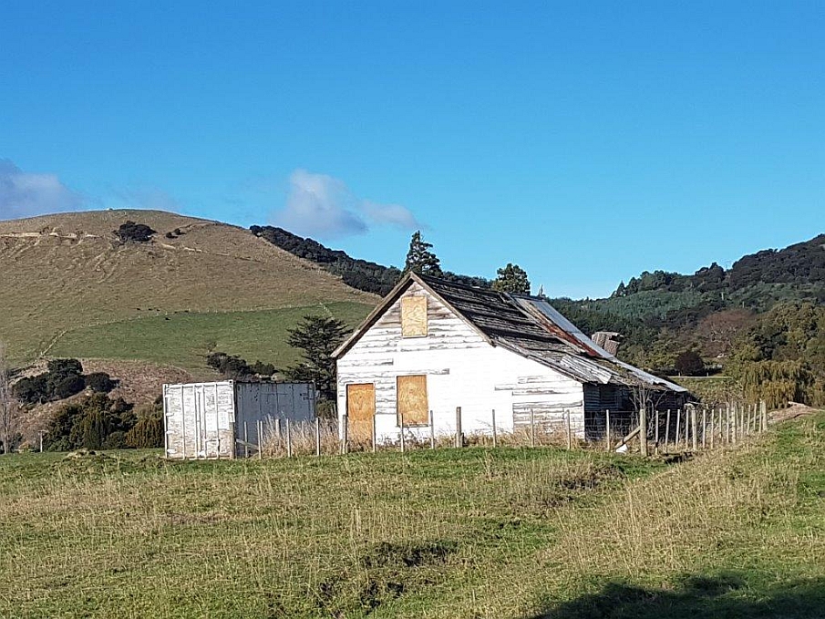
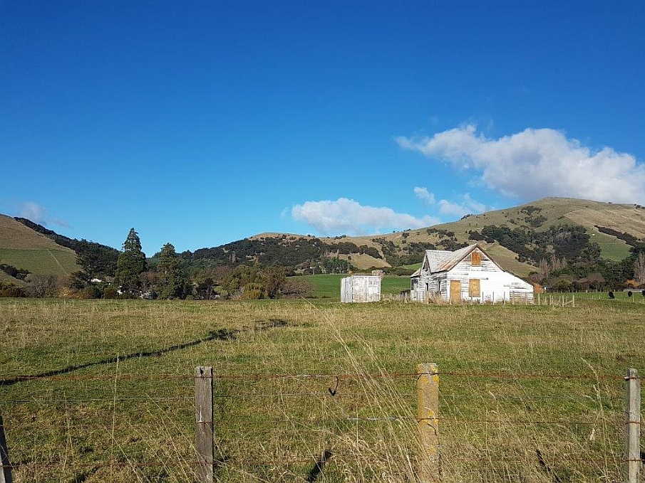
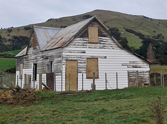
The French Farm House, situated about 400 metres from the shore, is thought to be one of the four houses existing when the French Navy departed in 1846. It is, therefore, one of the oldest surviving buildings in the South Island. Built to metric measurements from local totara, the house has an interesting internal structure comprising a number of small rooms with lined walls indicating that the building was probably used for accommodation. On the ground floor a larger space suggests communal use. Members of the working parties from the naval ships stationed at Akaroa may have slept there.
The quality of the building's construction which has ensured the house's survival and continued use suggest that it may have been intended to accomodate the naval officers. Exact details of the use of the building both during and after the departure of the French Navy however, remain unclear. The extent to which later owners used the property is also uncertain. The house, which has been unoccupied for at least the last 100 years, is now dilapidated but remains sound and essentially intact. Until c.2005 it was used as a hay barn. The paddock on which the house stands has not been cultivated since 1901, allowing conservation of archaeological evidence of French use.
The current owners, Owen and Veronica Brocherie, are committed to retaining the setting of the building intact. Both Owen and his father Terence who farmed the property before him, are committed to the conservation of the building, and have been working with the Akaroa Civic Trust to this end.
The Akaroa Civic Trust, an organisation dedicated to the preservation of the beauty and history of Akaroa and its surrounding area, has had an involvement in the project since 2001. Individual members of the Trust, with particular interests and skills in heritage conservation, formed a working party to assist the property owner with the considerable conservation issues relating to the building. In recent years, Civic Trust working parties have assisted with clearing hay from the building, propping the back (west) wall of the lean to part of the building to prevent its collapse and making the building weatherproof.