

By early 1942 the threat of Japanese invasion in the South Pacific meant an increased effort to provide defence for New Zealand's shores. Additional airfields were planned and associated secret aviation fuel depots were needed to hold the required fuel. The largest of all those depots built, the Bankside Fuel Depot (AR16), was built in 1942 to serve the nearby Te Pirita airfield which had been rapidly constructed to take American heavy bombers.
Designed by the Public Works Department, the construction of the Bankside Fuel Depot was a major undertaking involving the reuse of an existing tank and the creation of a bomb blast protection wall containing 97,000 bricks. Fencing, a pumping station, prefabricated accommodation and messroom buildings and railway sidings were also part of the Depot. The tank and prefabricated buildings have long since been removed, but the brick blast pit, and remnants of the pumping station, shafts and gate posts survive.
The Bankside Fuel Depot includes the largest and most intact example of a blast wall from the aviation fuel depots throughout New Zealand. This and associated surviving features from the Depot provide an insight into war time collaboration with respect to a very important yet rarely recognised part of New Zealand's defence effort during World War II.
List Entry Information
Status
Listed
List Entry Status
Historic Place Category 2
Access
Private/No Public Access
List Number
7727
Date Entered
15th February 2008
Date of Effect
15th February 2008
City/District Council
Selwyn District
Region
Canterbury Region
Extent of List Entry
Extent includes the land described as Pt RS 37020 and Lot 1 DP 407398 (RT 426055), Canterbury Land District and the brick structure known as the Bankside Fuel Depot blast pit thereon, and its fittings and fixtures, as well as remains of concrete shafts, remains of gate posts, and remains of the pumping station. Refer to extent map tabled at the Rārangi Kōrero Committee meeting on 6 April 2023.
Legal description
Pt RS 37020 and Lot 1 DP 407398 (RT 426055), Canterbury Land District.
Location Description
Approximately 500 metres heading west along Breadings Road from the Bankside sign on State Highway 1, just north of the Rakaia Bridge. There is a track off Breadings Road at approximately 150 metres west of Terrace Road, and the brick blast pit of the Bankside Fuel depot is 60 metres along that track. Remains of shafts are situated approximately 8-10 metres to the south-west of the brick blast pit, and a gate post is situated further south-west from these shafts. Remains of the pumping station is situated north-east of the brick blast pit.
Why is this place significant?
Cultural Significance
Social Significance or Value The construction of the Bankside Fuel Depot reflects the characteristics of the community in New Zealand in war time. Although it was probably the least used of all the aviation fuel depots built during World War II in New Zealand, it has social significance for those involved in its rapid construction, using materials available, and in a team response by those playing their part in the war effort.
Historic Significance
Historical Significance or Value The airfield was built at a time when the threat of Japanese invasion was still real and it was intended as a dispersal field for aircraft from Wigram and Ohakea, which were seen as easy targets. Although the airfield had its own tanks, approval was given at the same time for a secret reserve fuel depot at Bankside. It has historical significance as a reminder of a particular period in New Zealand history, and is the most intact physical remnant of the 17 aviation fuel depots planned around the country. The Bankside Fuel Depot provides an insight into collaboration between the Public Works Department personnel and engineering professionals in the construction of a 'secret' fuel depot site. Its construction was carried out in the spirit of secrecy, even if the reality was that it was not quite as secret as was intended by the Public Works Department.
Physical Significance
Archaeological Significance or Value The site has archaeological value in that it has the potential to provide evidence of the history of New Zealand through recognised archaeological techniques, even through the site post-dates 1900. Technological Significance or Value The Bankside Fuel Depot tank was built rapidly using recycled plate steel from dredges, demonstrating the 'no. 8 fencing wire' ethos of making do with what is available. The place also involved experimentation with induction and acoustic systems of protection. The blast wall was so securely constructed that the bricks were not salvageable for reuse elsewhere and thereby remain in their original location as the brick blast wall.
Why is this place Category 1 / Category 2?
Detail Of Assessed Criteria
a) The extent to which the place reflects important or representative aspects of New Zealand history The Bankside Fuel Depot represents an important aspect of New Zealand's war effort during the Second World War, that is, the rapid building of defences against invasion and the close association with the United States Defence Force. (b) The association of the place with events, persons, or ideas of importance in New Zealand history The site is associated with the defence of New Zealand against potential inva-sion during Second World War. It is also closely connected to the story of New Zealand's co-operative effort with the United States to combat the aggression of Japan in the Pacific. The scale of the Bankside Fuel Depot reflected the fact that it was built to serve the nearby Te Pirita airfield which had been con-structed to take heavy Flying Fortress bombers. (e) The community association with, or public esteem for the place Community association with, and public esteem for, the Bankside Fuel Depot has gained momentum recent decades, particularly with the growth of interest in war history. However, the fact that the pit has been used as a dump for items such as unwanted cars and even chemicals shows that part of the community at least has seen the place as little more than a tip. The interest and efforts of representatives of a number of groups and organisations are keen to see the site preserved. These include members of the Canterbury and Ashburton Branches of the New Zealand Historic Places Trust, the Selwyn District Council, the Department of Conservation, the Selwyn Plantation Board, the Ashburton Planes Association and the Ashburton Aviation Museum Society. (f) The potential of the place for public education The Bankside Fuel Depot adds to an understanding of the extensive network of defensive sites which were established very quickly to counter the threat of Japanese invasion. The role of coastal defence is reasonably well recognised, with a number of prominent sites in public ownership. Bankside Fuel Depot contributes to tell the story of the role of the airforce in the internal defence of New Zealand during the Second World War and is also a part of the story of New Zealand's association with the United States. The site is close to a main highway and is easily accessible. With appropriate interpretation and clearance of rubbish and contaminants, it would provide pub-lic education about a little known aspect of the war effort. (g) The technical accomplishment or value, or design of the place The Bankside Fuel Depot includes the most intact example of a blast wall from the aviation fuel depots throughout New Zealand. The Bankside Depot, with a capacity of holding 750,000 gallons, was the largest and the southernmost of the aviation fuel depots constructed in New Zealand. The Depot was associ-ated with experiments in induction and acoustic systems of protection which would be inconspicuous to the enemy from the air but be capable of detecting the approach of unauthorised persons. The site was also innovative in its use of recycled materials. (j) The importance of identifying rare types of historic places The Bankside Fuel Depot is one of only five surviving examples of the original 17 fuel depots planned as part of the war effort in New Zealand. (k)The extent to which the place forms part of a wider historical and cultural complex or historical and cultural landscape The Bankside Fuel Depot forms part of the wider complex of defence structures built for the Second World War, being the Te Pirita airfield, its underground aircraft pits, and, although they no longer remain, buildings associated with the site such as bunkhouses and a mess. Summary of Significance or Values This place was assessed against, and found it to qualify under the following criteria: a, b, e, f, g, j and k. Conclusion It is considered that this place qualifies as a Category II historic place.
Construction Professional
Name
Public Works Department
Type
Architect
Biography
No biography is currently available for this construction professional
Name
Public Works Department
Type
Architect
Biography
No biography is currently available for this construction professional
Construction Details
Start Year
1942
Type
Original Construction
Description
Fuel depot designed and construction completed.
Construction Materials
Brick and cement mortar for blast wall, poured concrete for pumping building, shafts and security fence posts, iron ladder rungs, metal gate hinge straps and gudgeon.
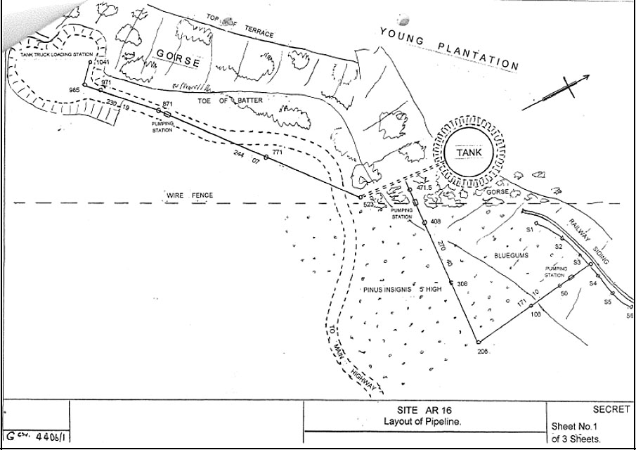
During the Second World War, the continuing advance of the Japanese threatening the South Pacific meant an increased effort to provide defence for New Zealand's shores. The plan was to increase the number of operational aircraft (both United States and New Zealand), possibly up to 600 aircraft. This required more runways and fuel depots, over and above the existing air strips in New Zealand. Authorisation for the construction of three new runways just north of the Rakaia River was authorised on 10 March 1942. This was the secret Te Pirita Airfield, which was constructed to take American heavy bombers, as well as other smaller satellite airfields. Te Pirita has been described as one of New Zealand's biggest 'secret' World War II construction efforts. By early 1942 the Government had realised that it had insufficient fuel reserves to cater for the proposed increase in aircraft numbers Prior to this time, the reserve fuel supply was based on what was needed for training requirements for a period of 12 months. In order to meet the changed circumstances, the Royal New Zealand Air Force (RNZAF) was authorised to build Aviation Reserve Fuel Depots adjacent to its air stations. These depots were for use by increased numbers of New Zealand squadrons, United States aircraft based in New Zealand and for Allied planes being ferried to the front. It was planned that 17 depots of tanks protected by triple-thickness brick blast walls would be built, and by mid 1942 construction of most of these had begun. On 10 March 1942, the same day that authorisation was given for the Te Pirita airfield, it was decided that 'one bulk tank should be located on the railway near the dispersal area on the Canterbury Plains for the servicing of American heavy bombers'. The initial proposal for a fuel tank at Coalgate or some other suitable point on the railway on the Canterbury Plains Ultimately Bankside was chosen as the location to serve the nearby Te Pirita Airfield. The Bankside Fuel Depot was known as AR16, an abbreviation for Aviation Reserve No.16 because it was number 16 out of 17 planned aviation fuel depots, although it appears that two of the planned depots were not built (refer to table in Appendix 3). The Bankside Fuel Depot was the largest of all those aviation fuel reserves, with a capacity for 750,000 gallons of fuel to be held. Others with a large capacity were the Seagrove/Ardmore Aviation Fuel Reserve (AR8) at Wiri Mountain which had a capacity for 700,000 gallons, and Rukuhia (AR9) in Cambridge and Ohakea (AR5) at Kakariki which both had a capacity of 600,000 gallons. The other fuel depots had a capacity ranging from 11,000 to 500,000 gallons. The Bankside Fuel Depot was constructed alongside the main railway line, from which a branch had been taken to enable fuel wagons to discharge their contents into the storage tank. It was built in an old gravel pit, surrounded by bluegums which were considered useful camouflage. The site work was carried out by the Public Works Department and its construction was a major undertaking. Dick Cotton was the structural engineer in charge of construction, Mr Hickey was the foreman, and R L (Bob) Lindsay surveyed the site prior to the blast wall being constructed. Ken Burgess was on the 'drag shovel' that excavated the gravel pit. It was planned to have the storage tank completed by 31 July 1942 in time for the receipt of fuel. The tank itself was constructed from second hand steel which had been fabricated for the dredges of Associated Gold Dredgers Ltd. However, this caused some delays because holes in the plate had to be welded. A bomb blast protection wall containing 97,000 bricks was constructed for the tank to sit in. The tank itself sat on oiled sand to ensure that it did not buckle. Filling of the tank did not actually commence until 31 August 1942. Records show that each bulk fuel depot was to be supplied with two standard design prefab buildings, 20 x 8 feet (6 x 2.4m), one to provide bunks for eight men and the other to be fitted out as a messroom and kitchen. The Depot was protected 24 hours a day by guards who were rostered on in pairs for a duty of four hours at a time. The site was also protected by a scrim or netting cover as well as quick growing shrubs and a total perimeter wire fence. A new railway siding off the main trunk line allowed the fuel to be delivered. Two types of security fence were trialled at Bankside, an induction and an acoustics system. The fuel from the tank was pumped via a pipeline to a point west of the Depot, where it could be loaded into tankers and transported by road to Te Pirita. Public Works Department correspondence of 31 March 1943 indicated that problems had been experienced with the fuel pumps and fittings. Alterations were carried out to the tank later that year. By the time the Te Pirita airfield was completed the threat of invasion had largely receded and it was never used for heavy aircraft. The airforce subsequently installed a beam radio for guiding aircraft and it was used for beam approach landing practice. By 1944, the Depot (tank, hutted accommodation, technical buildings and extensive fencing) was no longer in use. Instructions were given to dismantle and salvage the valuable equipment installed. At this time the Depot was still being maintained in working order by a man stationed at the site to turn the pumps over and guard the place. The fuel tank was sold to the Associated Motorists petrol Company and the buildings associated with the site were removed. The remains of the Bankside Fuel Depot are only one of five surviving of the original 15 built in New Zealand. The blast wall remains because, as with all the blast walls for the other aviation fuel depots at this time, the cement mortar used to bond the bricks meant that the bricks were not readily salvageable. In addition to the blast wall, traces of the security fence and the pipeline remain. The rail sidings were lifted in 1947. The land returned to the Selwyn Plantation Board for the sum of £20. Trees were planted around the site and soon it was all but forgotten apart from a few locals who saw it as a convenient rubbish tip for old cars and other junk, and a few who used it for ‘secluded parties'.
During the Second World War, the continuing advance of the Japanese threatening the South Pacific meant an increased effort to provide defence for New Zealand's shores. The plan was to increase the number of operational aircraft (both United States and New Zealand), possibly up to 600 aircraft. This required more runways and fuel depots, over and above the existing air strips in New Zealand. Authorisation for the construction of three new runways just north of the Rakaia River was authorised on 10 March 1942. This was the secret Te Pirita Airfield, which was constructed to take American heavy bombers, as well as other smaller satellite airfields. Te Pirita has been described as one of New Zealand's biggest 'secret' World War II construction efforts. By early 1942 the Government had realised that it had insufficient fuel reserves to cater for the proposed increase in aircraft numbers Prior to this time, the reserve fuel supply was based on what was needed for training requirements for a period of 12 months. In order to meet the changed circumstances, the Royal New Zealand Air Force (RNZAF) was authorised to build Aviation Reserve Fuel Depots adjacent to its air stations. These depots were for use by increased numbers of New Zealand squadrons, United States aircraft based in New Zealand and for Allied planes being ferried to the front. It was planned that 17 depots of tanks protected by triple-thickness brick blast walls would be built, and by mid 1942 construction of most of these had begun. On 10 March 1942, the same day that authorisation was given for the Te Pirita airfield, it was decided that 'one bulk tank should be located on the railway near the dispersal area on the Canterbury Plains for the servicing of American heavy bombers'. The initial proposal for a fuel tank at Coalgate or some other suitable point on the railway on the Canterbury Plains Ultimately Bankside was chosen as the location to serve the nearby Te Pirita Airfield. The Bankside Fuel Depot was known as AR16, an abbreviation for Aviation Reserve No.16 because it was number 16 out of 17 planned aviation fuel depots, although it appears that two of the planned depots were not built (refer to table in Appendix 3). The Bankside Fuel Depot was the largest of all those aviation fuel reserves, with a capacity for 750,000 gallons of fuel to be held. Others with a large capacity were the Seagrove/Ardmore Aviation Fuel Reserve (AR8) at Wiri Mountain which had a capacity for 700,000 gallons, and Rukuhia (AR9) in Cambridge and Ohakea (AR5) at Kakariki which both had a capacity of 600,000 gallons. The other fuel depots had a capacity ranging from 11,000 to 500,000 gallons. The Bankside Fuel Depot was constructed alongside the main railway line, from which a branch had been taken to enable fuel wagons to discharge their contents into the storage tank. It was built in an old gravel pit, surrounded by bluegums which were considered useful camouflage. The site work was carried out by the Public Works Department and its construction was a major undertaking. Dick Cotton was the structural engineer in charge of construction, Mr Hickey was the foreman, and R L (Bob) Lindsay surveyed the site prior to the blast wall being constructed. Ken Burgess was on the 'drag shovel' that excavated the gravel pit. It was planned to have the storage tank completed by 31 July 1942 in time for the receipt of fuel. The tank itself was constructed from second hand steel which had been fabricated for the dredges of Associated Gold Dredgers Ltd. However, this caused some delays because holes in the plate had to be welded. A bomb blast protection wall containing 97,000 bricks was constructed for the tank to sit in. The tank itself sat on oiled sand to ensure that it did not buckle. Filling of the tank did not actually commence until 31 August 1942. Records show that each bulk fuel depot was to be supplied with two standard design prefab buildings, 20 x 8 feet (6 x 2.4m), one to provide bunks for eight men and the other to be fitted out as a messroom and kitchen. The Depot was protected 24 hours a day by guards who were rostered on in pairs for a duty of four hours at a time. The site was also protected by a scrim or netting cover as well as quick growing shrubs and a total perimeter wire fence. A new railway siding off the main trunk line allowed the fuel to be delivered. Two types of security fence were trialled at Bankside, an induction and an acoustics system. The fuel from the tank was pumped via a pipeline to a point west of the Depot, where it could be loaded into tankers and transported by road to Te Pirita. Public Works Department correspondence of 31 March 1943 indicated that problems had been experienced with the fuel pumps and fittings. Alterations were carried out to the tank later that year. By the time the Te Pirita airfield was completed the threat of invasion had largely receded and it was never used for heavy aircraft. The airforce subsequently installed a beam radio for guiding aircraft and it was used for beam approach landing practice. By 1944, the Depot (tank, hutted accommodation, technical buildings and extensive fencing) was no longer in use. Instructions were given to dismantle and salvage the valuable equipment installed. At this time the Depot was still being maintained in working order by a man stationed at the site to turn the pumps over and guard the place. The fuel tank was sold to the Associated Motorists petrol Company and the buildings associated with the site were removed. The remains of the Bankside Fuel Depot are only one of five surviving of the original 15 built in New Zealand. The blast wall remains because, as with all the blast walls for the other aviation fuel depots at this time, the cement mortar used to bond the bricks meant that the bricks were not readily salvageable. In addition to the blast wall, traces of the security fence and the pipeline remain. The rail sidings were lifted in 1947. The land returned to the Selwyn Plantation Board for the sum of £20. Trees were planted around the site and soon it was all but forgotten apart from a few locals who saw it as a convenient rubbish tip for old cars and other junk, and a few who used it for ‘secluded parties'.
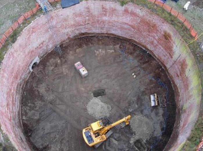
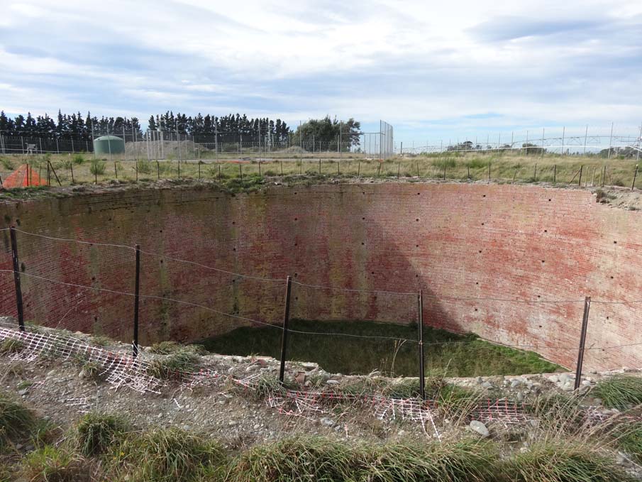
At the time of writing this report, the site is deemed a contaminated site and no access is permitted. The physical description and analysis is based on site visits and description by Ian Hill of the Department of Conservation and from photographs of the site taken by Ecan (Environment Canterbury) after old cars were removed from the brick blast pit in 2006. The main surviving feature of the Bankside Fuel Depot is a circular brick walled tank pit, approximately 40 metres in diameter and 9-12 metres deep. The tank itself is no longer at the site. At some 8-10 metres to the south-west of the tank pit are two sets of vertical concrete shafts, side by side. The shaft closest to the tank pit has iron ladder rungs set into concrete. The shafts have been filled in to within one metre of the top. A bank, possibly the remains of a loading bank, is situated adjacent to the shafts. In this area there is a number of Army style concrete security fence posts (some broken) and one intact standing gate post, complete with gudgeon and hinge straps. To the north east of the pit, there are the remains of a pumping station building. The location of the fuel pipeline is visible. All other elements are fragmentary only. All of these features are included in the extent of registration. The tank pit is located in pine forest and the surroundings are overgrown with gorse, broom and blackberry. The area has been modified as the result of previous logging in the 1980s, whereas the brick tank pit remains relatively intact, albeit now as a dump.
At the time of writing this report, the site is deemed a contaminated site and no access is permitted. The physical description and analysis is based on site visits and description by Ian Hill of the Department of Conservation and from photographs of the site taken by Ecan (Environment Canterbury) after old cars were removed from the brick blast pit in 2006. The main surviving feature of the Bankside Fuel Depot is a circular brick walled tank pit, approximately 40 metres in diameter and 9-12 metres deep. The tank itself is no longer at the site. At some 8-10 metres to the south-west of the tank pit are two sets of vertical concrete shafts, side by side. The shaft closest to the tank pit has iron ladder rungs set into concrete. The shafts have been filled in to within one metre of the top. A bank, possibly the remains of a loading bank, is situated adjacent to the shafts. In this area there is a number of Army style concrete security fence posts (some broken) and one intact standing gate post, complete with gudgeon and hinge straps. To the north east of the pit, there are the remains of a pumping station building. The location of the fuel pipeline is visible. All other elements are fragmentary only. All of these features are included in the extent of registration. The tank pit is located in pine forest and the surroundings are overgrown with gorse, broom and blackberry. The area has been modified as the result of previous logging in the 1980s, whereas the brick tank pit remains relatively intact, albeit now as a dump.
Historical and Associated Iwi / Hapū / Whānau
Completion Date
23rd October 2007
Report Written By
Robyn Burgess
Information Sources
Burns, 2000
'Aviation Reserve Fuel Depots', in Forts and Works: Thoughts and Words on the Defence of New Zealand. Defence of New Zealand Study Group, Wellington, Volume 9, August 2000,
Cooke, 2000
P. Cooke, Defending New Zealand; Ramparts on the Sea 1840-1950s, Wellington, 2000
Phillips, 2000 (2)
Phillips, Flying by Bradshaw: Memoirs of a Pioneer Pilot 1933-1975, Proctor Publications, 2000.
Other Information
A fully referenced listing report is available from the HNZPT Southern region office Please note that entry on the New Zealand Heritage List/Rarangi Korero identifies only the heritage values of the property concerned, and should not be construed as advice on the state of the property, or as a comment of its soundness or safety, including in regard to earthquake risk, safety in the event of fire, or insanitary conditions.
Former Usages
General Usage: Defence
Specific Usage: Fuel Depot
Former Usages
General Usage: Defence
Specific Usage: Fuel Depot
Location
Sign up to hear more
Get the latest heritage news, features and events delivered
straight to your inbox.
