

The Kaiwharawhara Stream was selected as the source for the water supply, because of its clean water (other streams were being used as sewers) and its elevation (allowing the water to flow by gravity). Work finally got underway in 1872, with the building of a tunnel through Baker's Hill to the head of the Aro Valley and at the other end of the tunnel a distributing basin. Shortage of funds at this point delayed the construction of the dam and so a small weir was placed across the Kaiwharawhara Stream to divert a flow into the tunnel with the distributing basin acting as a reservoir. The houses of Wellington began receiving piped water from this source in May 1874.
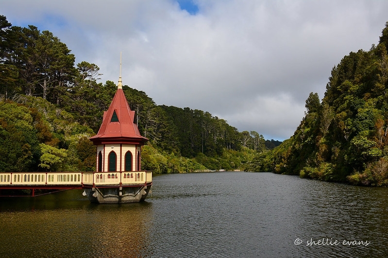
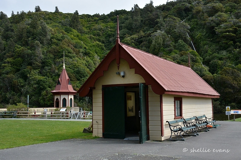
After further funds were authorised construction on the dam started in 1876. It was completed by January 1878 by contractor J Saunders whose workforce built it without the aid of machinery. In dimensions the dam rises approximately 21 metres from the stream bed, and is 122 metres at its widest point. The type of dam is called a puddled clay core. It builds up a central core of the dam in processed clay which is waterproof. Stoney earth material is then added either side of this core to form the body of the dam. Inside the dam tunnels convey the water pipes and the valves controlling the water entering these pipes are opened and closed from a 'valve tower'. The valve tower for the Lower Karori Dam is situated in the surrounding lake and accessed via a bridge. This tower and a boat shed were built at approximately the same time as the dam.
As Wellington's water network expanded (including the Upper Karori Dam built 190810), the dam became the focal point as the terminus, receiving water from other sources. This occurred with water from the Orongorongo River in 1926 and Kaitoke scheme in 1957. Chemical treatment of the water in Lower Karori Dam started in 1930 and a small pump house was added in 1935. The 1950s modifications in conjunction with the Kaitoke scheme were very significant, with the addition of a large circular contact tank and three buildings (a new pump house, valve house and chlorine store). With concerns about its water quality and safety on an earthquake fault, the dam was decommissioned in 1997. With a lessening role in supplying water, the Karori waterworks reserve was gifted back to Wellington City Council for the Karori Wildlife Sanctuary in July 2004.
Set within the natural environment of the Karori Wildlife Sanctuary 'a worldfirst conservation attraction', the Lower Karori Dam is of both regional and national significance. The dam is one of Wellington's oldest surviving engineering constructions which, together with its associated structures, tell the story of Wellington's first public water supply system. The distributing basin that was used in place of the dam until its completion in 1878 has been filled in but remains beneath ground, while water from present water supply systems still flow through the 1872 tunnel to Aro Valley. The dam itself is the first water works dam to be built by a municipality, and a distinctive example of the puddle clay core earth dam technique. Also of interest are the valve tower and boat shed, utilitarian structures which were finished to be aesthetically pleasing. The place is set within ideal surroundings for others to learn about these early engineering structures and the water supply system with significant features identified and interpreted.
List Entry Information
Status
Listed
List Entry Status
Historic Place Category 1
Access
Able to Visit
List Number
7750
Date Entered
14th May 2008
Date of Effect
14th May 2008
City/District Council
Wellington City
Region
Wellington Region
Extent of List Entry
Extent includes part of the land described in certificate of title WN52413, part Legal Road, Wellington Land District; NZ Gazette 1982, p. 714 and NZ Gazette 1982, p. 1390, and the structures collectively known as the Lower Karori Dam thereon, its fittings and fixtures, and associated features. The registration includes the entire dam structure as far as where it touches the hillsides to its east and west, concrete on upstream face only, and down to the lowest point of foundations, and associated features including the valve tower, the boathouse, the eastern and western spillways, the break pressure tank, the tunnels, pipes, the distributing basin and reservoir. Registration includes all items integral to the operation of the historical dam structures described in the registration report except for the following items which have been assessed and specifically excluded: the foundation of the 1935 pumping station, the Kaitoke system pum-phouse, the chlorine store, the valve house, the contact tank and properties on the Disley Street site. The registration also excludes other items not associated with the historical dam structures but contained within the boundary of the registration, for example the predator proof fence. (Refer to Extent of Registration Map in Appendix 1 of the Registration Report for further information).
Legal description
Lot 1 DP 313319 (RT WN 52413), part Legal Road (made public by T 72086), Wellington Land District, Pt Sec 1 Upper Kaiwharawhara District marked A on SO 32281 (NZ Gazette 1982, p. 714), Pt Sec 10 Owhiro District marked A on SO 32922 (NZ Gazette 1982, p. 1390).
Location Description
Located in the Karori Wildlife Sanctuary, Wellington.
Why is this place significant?
Cultural Significance
Technological Significance or Value The dam is a good example of nineteenth century puddle clay core earth dam technology. The only significant repair to the structure was when a leak in the dam occurred in 1930, and a small section of puddle clay core about 12ft (3.6m) deep and similar width was replaced. It also has characteristics which distinguish it from other examples of puddled clay core earth dams in New Zealand.
Historic Significance
Historical Significance or Value The dam is of very high historical significance to Wellington, where it is one of the oldest surviving engineering constructions and represents Wellington's first public water supply. It continues to play a role a role in Wellington's water supply today with water from other sources still flowing under the Karori dam and out through the 1872 tunnel. It is also significant nationally as the oldest water works dam built by a municipality. Water works dams built by other municipalities appear in the early twentieth century while earlier examples of water works dams, or in use in mining, were privately built.
Physical Significance
Aesthetic Significance or Value Set within pleasing natural surroundings the reservoir area has a strong place in Wellington's recreational and aesthetic past, having been visited by tourists (domestic and international) for a century and a third. The dam itself has been an iconic subject for postcard photographers in the golden years of that craft (19001930). The design of the tower makes a strong statement in support of the beauty of the location, using one of the few structures to be seen and appreciated by visitors. It and the boatshed could have been finished in a plain utilitaran manner, in keeping with their function but, instead, aesthetics were taken into account. Archaeological Significance or Value The Lower Karori Dam and its associated features form an important industrial archaeological landscape. The original features of the dam are still intact and most are in good condition and a relatively unmodified form. The level of integrity of the site is rare for a nineteenth century industrial complex. The site has great potential to educate the public about the growth and development of Wellington's water supply and pioneering engineering feats.
Why is this place Category 1 / Category 2?
Detail Of Assessed Criteria
(a) The extent to which the place reflects important or representative aspects of New Zealand history It strongly reflects the engineering history of early Wellington, including the specialisms of mining, surveying, tunnelling, dambuilding, and waterworks engineering. Remains of early gold mining will exist under its waters. (b) The association of the place with events, persons, or ideas of importance in New Zealand history At least four early New Zealand engineers are associated with the dam, including John Blackett, who was later appointed Engineer in chief of New Zealand. The others are Richard Mixer Skeet, Nicolas Marchant and Robert Mudge Marchant. © The potential of the place to provide knowledge of New Zealand history An investigation of the dam could provide additional information relating to its method of construction and the use of claypuddling technology. An analysis of the distribution tunnels and waterworks infrastructure could also provide information on the development of waterworks engineering. (e) The community association with, or public esteem for the place The beauty of the Karori reservoir area has long been held high in public esteem, and this has been added to recently with the creation of the Karori Wildlife Sanctuary which aims to conserve both that beauty and the wildlife of the area. In 200607 the sanctuary received over 64,000 visits. The history of human intervention in the area (both mining and waterworks engineering) is also appreciated by some people. The gold mining and water works have in particular been the subjects of published works, including James Brodie's The Karori Goldrush 196973, (Karori Historical Society, 1997), a number of articles in the Karori Historical Society's journal The Stockade, and the history of Wellington's water works Our Water History On Tap by Peter Cooke, published by the Greater Wellington Regional Council in 2007. (f) The potential of the place for public education The dam has great potential to help educate the public about Wellington and New Zealand's engineering past and water supply network (the Sanctuary Trust has already started doing this in regard to mining activities in the area). The site is very accessible, only 3 km from downtown Wellington and has interpretation signs in place for much of its heritage. (g) The technical accomplishment or value, or design of the place The puddled clay core of the Lower Karori Dam is of particular interest. It can be seen as a contemporaneous example of nineteenth century puddle clay core earth dam technology and as a testament to the durability of these techniques when done correctly, with only one significant repair having been made to the core in the 130 years since the Dam's construction. (h) The symbolic or commemorative value of the place There is likely to have been a ceremony at the dam shortly after it was commissioned (but details are unknown). Certainly such rituals accompanied other milestones in its waterworks history (turning on Orongorongo water in December 1926, or handing the waterworks reserve to the Wildlife Sanctuary in 2004). (k) The extent to which the place forms part of a wider historical and cultural complex or historical and cultural landscape At its peak in the 195070s, the Karori Dam was the heart of a water supply network stretching as far north as Kaitoke beyond Upper Hutt (57km away), as far east as the Orongorongo River (in the Wainuiomata catchment) and supplied users as far north as Porirua with water of the highest quality. The water engineering represented by this and the Upper Karori Dam is an integral part of the Karori Wildlife Sanctuary. Conclusion Set within the natural environment of the Karori Wildlife Sanctuary 'a worldfirst conservation attraction', the Lower Karori Dam is of both regional and national significance. The dam is one of Wellington's oldest surviving engineering constructions which, together with its associated structures, tell the story of Wellington's first public water supply system. The distributing basin that was used in place of the dam until its completion in 1878 has been filled in but remains beneath ground, while water from present water supply systems still flow through the 1872 tunnel to Aro Valley. The dam itself is the first water works dam to be built by a municipality, and a distinctive example of the puddle clay core earth dam technique. Also of interest are the valve tower and boat shed, utilitarian structures which were finished to be aesthetically pleasing. The place is set within ideal surroundings for others to learn about these early engineering structures and the water supply system with significant features identified and interpreted.
Construction Professional
Name
Saunders, J.
Type
Builder
Biography
No biography is currently available for this construction professional
Name
Marchant, Nicholas
Type
Engineer
Biography
Civil Engineer.
Construction Details
Start Year
1871
Finish Year
1874
Type
Designed
Description
Including associated engineering features such as the weir and tunnel to the distributing basin
Start Year
1872
Finish Year
1878
Type
Original Construction
Start Year
1906
Type
Other
Description
Catchment purchased and farming stopped.
Start Year
1908
Type
Addition
Description
Upper Karori dam bypass added
Start Year
1924
Type
Modification
Description
Bridges to valve tower and over byewash A replaced
Start Year
1926
Type
Addition
Description
Orongorongo water source added
Start Year
1930
Type
Addition
Description
Chlorination treatment plant added
Start Year
1935
Type
Addition
Description
Pump house added and distributing basin decommissioned (it was later filled in)
Start Year
1944
Type
Addition
Description
Long Gully (South Karori Stream) source added
Start Year
1957
Type
Addition
Description
Pumping station and valve house added for new Kaitoke source (Hutt River)
Start Year
1959
Type
Other
Description
Original cottage demolished
Start Year
1962
Type
Addition
Description
Contact tank (now Aro Reservoir) and chlorine store built
Start Year
1968
Type
Modification
Description
Pumping station capacity increased
Start Year
1997
Type
Other
Description
Dam decommissioned as a source of water
Start Year
2006
Type
Other
Description
Start of decommissioning of pumping station
Construction Materials
Dam: earth, clay, concrete.
Maori who lived in the general area in precontact times named the stream on which the Lower Karori Dam sits. The name Kaiwharahara refers to eating (kai) the black berries of a bush (wharawhara, or astelia banksii) which grew in its valley up from the harbour. Maori are therefore assumed to have used the stream for fishing, gathering, recreation, and as a water source and access way, but the dam site is remote and no signs of habitation there are known. After European settlement the stream banks were used for farming. From 1869 gold deposits found along the stream led to prospecting, with mining starting in July that year. At least five companies tried their hand, driving mine shafts into the hill east of the stream. The Baker's Hill Co claim was just upstream of today's dam site, and the Golden Crown Co just downstream. The Lower Karori Dam was completed in January 1878 (not 1874 as has been popularly believed) but was the culmination of a number of attempts to bring water to Wellington over the previous decade. It would be the earliest water works dam to be built by a municipality. Water works dams built by other municipalities appear in the early twentieth century, for example Auckland City Council built a series of timber dams in 1901 and Petone Borough Council built the Korokoko dam in 1903. Earlier examples of water works dams, such as those at Ross Creek, Dunedin (Register No 4922) from 1867, or in use in mining, were privately built. Since being designated the capital in 1865, Wellington had grown apace. Significant development of the infrastructure was planned and the population was expected to increase rapidly, with immigration schemes already bringing them in. The population would grow from approximately 5,000 in 1865 to 18,000 by 1874. In 1867 the Wellington Town Board started planning a water supply scheme for public use. At this time the public were relying on 'minor streams, wells and water collected from roofs' for their water supply. The Town Board had already appointed a Board of Works to oversee any municipal works authorised by the city in 1864, and later that same year the first Town Engineer, [Robert] Mixer Skeet (1832-1894) was appointed. Skeet considered two streams should be tapped for a water supply, the Te Aro (or Waimapihi) Stream in Polhill's Gully (now Aro Valley), for residents in southern Wellington, with the Kaiwharawhara Stream supplying the Thorndon Ward. This latter would be tapped near Baker's Hill (an early name for the area where Raroa Road now crosses above Karori Tunnel). No constructional plans were drawn up because the estimated cost of the work was deemed too high for the city to afford, and factional politics prevented any agreement. Another confusion that dogged these plans was that the Kaiwharawhara Stream was not within the Town Board's boundary. Commenting on these proposals, another engineer George Aicken (a Town Commissioner) suggested a 20ftdeep reservoir of four acres should be built to provide storage for 1214,000 people, a population the town was expecting. Skeet's successor as Town Engineer was Nicholas Marchant (18361907), who took over in October 1867. Marchant, who would best known for his work on Karori water works, retiring as City Engineer just two months after the dam was eventually finished, picked up the current proposals for a water supply and dam. Realising the financial difficulties attendant on the city funding this scheme, he invited private interests to suggest a publicprivate partnership. Such as had been successful in Dunedin where a private waterworks company had built two water supply dams (on Ross Creek, Register No 4922) for the town, and levied rates to pay for the work. In Wellington an engineer with considerable experience in railways construction in the United Kingdom, Robert Mudge Marchant (no relation) submitted a proposal similar to Dunedin's. He proposed bringing water from the Kaiwharawhara Stream down its right bank until adjacent to Northland Hill, which would be tunnelled to bring the supply through to Tinakori Road and beyond. In a stormy meeting in August 1868, however, ratepayers soundly rejected this proposal. At this point the Town Board was offered surplus water from a small Provincial Government scheme that had laid pipes from a spring on Tinakori Road, along Hill Street (involving a tunnel) to a tank beside the old General Assembly (site today of the General Assembly Library building). This was used for firefighting, as well as supplying Her Majesty's warships from Browns Wharf. The Town Board declined to buy from this supply, believing that the source would be inadequate for Wellington's growing population and the Government Tank leaky. This spurred the Town Board to push ahead its efforts to develop their own supply. In 1869 another private venture got under way, returning to tap the Te Aro Stream and reticulate its water. This was by John and William Beck, contractors who had been involved in the Government Hill Street scheme two years earlier. Following the precedent set by the Wellington Gas Company which had ordered pipes for manufactured or 'town' gas supplies, the Becks started by imported their water piping. They had not, however, sorted out their permissions and the Town Board declined consent, in order to protect commercial users of the stream (brewers and bottlers mainly). It is possible that the Becks had started their weir or intake on the stream, from which to divert part of the flow. The Town Engineer Nicholas Marchant believed the Kaiwharawhara Stream to be the best for a water supply, and spent the next few months measuring its flow. The stream was chosen for its clean water (other streams that originally supplied potable water were being increasingly compromised when also used as sewers). The site was selected because of its elevation (allowing the water to flow by gravity). The Town Board had been promoted to a Borough Council under the Municipal Corporations Act 1867 (though the promotion had been delayed by ratepayer unease over the cost of some of these water works schemes). He took the best aspects of preceding proposals to formally suggest in March 1871 a dam on the stream at Baker's Hill, a tunnel from that point under Baker's Hill to the head of Aro Valley, and at the other end of the tunnel a distributing basin. The pipes which the council had purchased from the Becks, would be used to reticulate throughout the city, starting down Aro Valley. The site chosen for the dam was favoured because it 'little exceeds two chains in width [44 yards, 40m] at the top and depth of 60ft [18.2m]'. These dimensions were important because it meant that a relatively narrow dam could impound (or store) a useful volume of water. This scheme was costed at £17,358. A Wellington Waterworks Bill was drafted in June 1871 to authorise a loan (of £25,000) to pay for it. This bill also listed the owners whose land would have to be taken before starting the work (and a lengthy period of haggling began over valuations). The Bill gave the mining companies there, who were prospecting for gold, a twoyear breathing period. The only other issue was arranging jurisdiction over the stream with the Provincial Government. This was handled through a Municipal Corporations Waterworks Bill, which was passed in 1872 and in which the Crown vested the water rights with the corporation. A waterworks committee had been formed by Wellington City Council in December 1871, and this committee selected all contractors, and oversaw ordering of materials and the progress of work. Another civil engineer, John Blackett (18181893), was contracted to consult in 1872, and a works overseer appointed the following year. The first work contract was the tunnel through Baker's Hill. Ebenezer Short won the tender, started in February 1872 and had it blasted through in eight months. The next work was the distributing basin at the head of Aro Valley (on the corner of today's Raroa Road and Mt Pleasant Road). The Becks were interested in this job (having already considered such a reservoir in the valley) but another contractor, Saunders & O'Malley won it. Their tender of £3,749 was cheapest and they started work early in 1873. The contract for laying 22km of pipelines was also let, in April 1873, to Collie & Co. The distributing basin was itself a huge and slow job. It was a boatshaped concrete basin, with the ‘bow' facing into the hill through which the tunnel was cut. Built in a small valley nestled up the side of a bigger valley (above Holloway Road), it required very deep foundations (90ft or 27m) for its ‘stern'. A wet winter and a slip of earth into the excavation slowed the project. These works and rising prices of labour and iron consumed more money than intended. By early in 1874 much of the loan raised for the water works had been spent. These financial constraints had ‘rendered it necessary to abandon the large reservoir [on Kaiwharawhara Stream] for the present' (the NZ Mail reported on 17 January 1874) and instead to double the capacity of the distributing basin (to 1 million gallons). Enlarging the basin had been aided by the large slip on the site during earlier work. A water supply would still be achieved without the dam, and to do so a small weir was placed across the Kaiwharawhara Stream to divert a flow into the tunnel. This filled the distributing reservoir and after the reticulated pipes were checked for pressure, the houses of Wellington (that had signed up for connections) started receiving piped water from early May 1874. The Wellington Independent reported that when water was first sent from the distributing basin down the pipes that ‘the full force from the reservoir was flushed through the mains to their extreme range as far as the lower end of Tinakori Road, and the pipes with one exception proved equal to the pressure'. ‘The want of an abundance of water' was a thing of the past, Nicholas Marchant said. The distributing basin filled the role of the dam reservoir for four years. When the dam was built, the basin carried on in the role of a service reservoir. A second Wellington Waterworks Act, passed in August 1874, authorised a second loan of £25,000. It was stated expressly to be to ‘extend the pipes and construct a reservoir on the main stream'. Marchant restarted work on his plans in September 1874. The following year in May he was authorised to proceed and called for tenders from contractors. J Saunders (presumed to be the same as built the basin) was successful with a quote for £17,195. Saunders was contracted for the work in October 1876 and got under way the following month. He was asked not only to maintain the flow of water coming in through the tunnel from the weir, but to increase it, such was the rising demand from the city. He built temporary works to this end, which probably involved raising the height of the weir or in some other way increasing the offtake from the stream. Little detail has survived of how Saunders built the dam. It certainly overlaid the original weir and tunnel entrance, and allowed for the prescribed overflow to continue down the stream (via another exit from the tunnel). There is some evidence underneath the dam that the original culvert from the weir to the tunnel entrance was by this stage encased in an arch of bricks, which was then buried as the dam was built up. This brick tunnelling extends from hard rock out to the base of the valve tower, suggesting the original weir may have been at or near the site of this tower. The dam was to be a puddled clay core dam. The technique of clay puddling in dam building was first used in Britain in the 1760s, in widespread practice by the 1820s, but still used well into the 20th century. To prepare for the clay core of the dam, a trench was built across the valley on the line of the dam. This went down to at least solid rock, and may have gone further. Into this trench was thrown a clay and sand mixture, the clay to be ‘of good and approved quality, well worked with water and passed through the pug mill to free it of stones and rubbish. The use of pug mills to process the clay was relatively new when Marchant used it. Great care to be taken after it [the puddle, was] placed to preserve it from the effects of sun, air, wind, cracks and other flaws.' Working the clay was called ‘puddling' and usually involved barefooted labourers working it with water and their feet. This puddled clay core would provide the waterproof element in the dam wall. As it built up, it was sandwiched between embankments of stony earth in front and behind. Fine material was added immediately adjacent to the clay core, with intermediate material and finally coarse stony material as the outer layer. Each of these layers was progressively sloped closer to the horizontal, leaving angles approximately 1in2 or 3 at the exterior. The upstream shoulder was then covered with a concrete lining about sixinches thick, as wave protection. Other examples of puddled clay core dams in New Zealand include the Ross Creek No 1 (1867, water supply, Register No 4922), Hochsetter (1877, mining), Druggans (19001902, mining). Bob Offer, a qualified engineer and an expert on dams in New Zealand has noted that the Lower Karori Dam has some features that distinguish it from other puddled clay core examples, in particular the Ross Creek dam that preceded it. These features include: It is the tallest use of a puddled clay core in New Zealand. The use of three zones of material on the upstream shoulder, extending from fine material next to the core and moving outwards via intermediate and then to coarse. The use of a pug mill for processing some of the clay core material. The use of concrete on the upstream slope, in a thin facing, as wave protection. The diversion of the line of the off take to ensure that it passed through the right abutment rock and not the dam (contrary to the principal drawing'. Offer went on to comment that ‘given the innovations used in its construction the dam deserves to be described as a landmark in New Zealand's dam building history'. Modifications were made to the dam as it was built, so the plans are not exactly as it is now. The cross sections pay virtually no heed to the undulating country on which the dam was set. The bridge to the valve tower was launched from the nearest point, the lakeside rather than the dam crest. The plans show the dam built to a height of 71ft (21.9m), presumably taken from the bed of the stream at the weir. In later investigations, however, Nicholas Marchant said he lowered the top (without specifying by how much), and brought the front or upstream wall 29ft (8.8m) closer to the clay core, to suit the ground. This had the effect of reducing the volume of material needed by the dam and was probably occasioned by the contractor having to make extra excavations for the puddle trench. After digging a bigger trench Saunders placed an extra 1700 cubic yards of puddled clay in it, and an extra 8,000 cubic yards of earth in the dam filling either side of it. In the end his extra expenses brought the dam's total cost to £19,500, and the whole system to £80,000 (and equivalent of $10 million today). Dam construction took from November 1876 until January 1878. On 24 January 1878 Nicholas Marchant declared it complete and ordered the filling to begin the following morning. It served water to Wellington for the next 124 years. As part of the dam a valve tower was built to allow access to the water inlet valves (it was and remains connected to the eastern shore by a bridge). Though it was finished with an octagonal structure and capped with an ornate neogothicstyle roof, with which to keep the weather out, the valve tower was an integral part of the dam through which the caretaker could control the outflow of water. A photograph dating from the building of the dam shows how integrated the valve tower is into the dam structure and suggests the structure was completed before the dam was filled in January 1878. The original design of the dam included two overflow channels, or byewashes, which were completed soon after the dam was filled. ‘Byewash A' was in the east near the valve tower bridge with ‘Byewash B' at the dam's western end. A byewash was merely an overflow, which controlled how and where excess water flowed over the dam crest. Their major benefit was that they prevented scouring of the dam's vital earth filling. The little bridge over Byewash A features in many early photos of the dam, and a spillway from this overflow, comprising of four distinct construction types, remains. A timber section of this spillway has been replaced in the past, but the current timber section is sympathetic to the original design. A precast concrete pipe and concrete culvert have replaced other parts of this spillway. The western spillway, understood to have been entirely comprised of timber, was replaced by concrete works in the 1940s. Also seen in early photos of the dam (at least by 1880) are two buildings, the boat shed and caretaker's cottage. The boat shed was built just upstream of the dam. The building can just be seen in the photo of the dam about to be filled, suggesting that it was built at the same time as the dam itself (between 18761878). The Sanctuary's interpretation suggests that the building was erected to house the Governor General's boat with the reservoir stocked with trout for him to fish in. By the 1920s it was described as a tool shed and it has also been an office and store. Buttresses were added on the south side, reputedly added after it was blown over in a gale in the 1920s. Until the 1990s it was partitioned into two rooms at which time it was restored, and given a new foundation. The caretaker's cottage was just downstream of the dam (it was where the car park is now), but was removed in 1959, presumably to make way for the contact tank, work on which started soon thereafter. Staff, numbering up to four caretakers, were thereafter accommodated in the nearby streets. The Karori Reservoir, as the area became known, became a destination for tourists and a subject of many commercial postcard photographs. It was intended from the start to be an attractive recreational facility, with the downstream slope of the dam grassed, trees planted and boating permitted (initially). Low pressure from Karori water and an inadequate supply led to other water supply dams being constructed to supply Wellington, starting with the first Wainuiomata dam in 1884. After this, comparisons were able to be made with Karori water which at times was deemed ‘inferior in quality' and colour. Some of this was due to the catchment around the Karori reservoir being used by a dairy farm and sheep run, which was described as ‘thoroughly dirty'. Only when a second dam was also contemplated in this catchment, in 1906, did the city acquire the catchment (mostly from farmer AB Fitchett) and prohibited any farming or hunting near its shores. The second or upper Karori dam was built in 1908. Its only effect on the original dam was a change in name, to the Lower Karori Dam. Functionally it augmented the capacity of the lower dam by keeping it full rather than supplying water to users directly. A small pipe (8inch, 200mm) was laid from the upper dam to bypass the lower dam, running down the eastern or right bank. This required a break pressure tank being built at the lower dam (to reduce the pressure of water before it entered the water supply system). Modifications were required when a major new source of water, from the Orongorongo River, was brought to Karori in 1926. The 21inch pipe for it came up to the dam over the eastern end, and required an outlet be built by the bridge to the valve tower. A ceremony here on 23 December 1926 officially turned on water from the Orongorongo project. The OrongorongotoKarori main became known as the ‘OK' main and significantly boosted the water coming through the Karori dam facilities. Other aspects of renewal of the dam's facilities occurred in the mid 1920s. Two plans dating from 1924 show a new bridge to the valve tower and a culvert replacing the small bridge that carried the roadway over the eastern byewash. The quality of water continued to get more attention. The city's first chlorination plant was begun at the Lower Karori Dam in 1929. The addition of chlorine in safe quantities killed off micro organisms that could carry disease and taint the taste and smell of water. A plan shows a small chlorination plant and bottle store up on the dam crest, at its eastern end. A leak in the dam was fixed in 1930, in which a small section of puddle clay core about 12ft (3.6m) deep and similar width was replaced. The distributing basin at the head of Aro Valley appears to have been decommissioned in approximately 1929 with correspondence from concerned rate payers regarding damage to trees and the danger of the reservoir to children appearing from this date, suggesting that the area was no longer being actively managed. The pressure of the water's flow was instead controlled via a breakpressure tank. The distributing basin was not filled in at this time and subsequently in 1942 the local fire service sent a deputation to the Mayor asking that it be kept filled with water as an auxiliary fire supply. After an inspection of the basin was conducted and repairs in concrete to a crack in the floor made this proposal was agreed with the proviso that the fire service could fill it with no more than 8ft of water (approximately 330,000 gallons) and a fire plug was cut in to enable this. It is not yet known when it stopped being used for this purpose but it was finally filled in 1963 using spoil from the Terrace parking building and the vicinity to make way for a yard storing council pipes. It continues to be used for this purpose. In 1935 a local pumping station was built at the Karori dam to feed Karori users (no doubt required by the exceptional height above sea level of the Karori service reservoir, 844ft (257m) up Wrights Hill Road). This 1935 pumping station is the only ancillary structure (apart from the caretaker's cottage and the 1929 chlorination plant and bottle store) to have since been removed. It was a building of approximately 8m x 4m, of timber construction on a concrete foundation (with a smaller valve out house immediately to its north). These were sighted to the north of and below the level of the northern tunnel exit, and beside the eastern spillway's confluence with the Kaiwharawhara stream. After the larger pumping station was built in the 1950s for the Kaitoke scheme this pumping station was decommissioned. The exact date of its demolition is not known, but its foundation can still be seen. The catchment feeding the Karori dams was augmented in 1945 by pumping water from Long Gully, a branch of the South Karori Stream, over a ridge behind the upper Karori Dam. This supply was discontinued when another major source, the Hutt River, was brought to Karori. Planning for this started in the 1940s, and was completed in 1957. The Hutt River or Kaitoke system was another runoftheriver intake (like that on the Orongorongo River) and used the Karori dams for its storage. It also introduced a backpumping capacity for when the river water was too low or turgid to be drawn, and so a large pumphouse was built at Karori in 1956, below the Lower Karori Dam. This allowed water to be pumped back up the 30inch pipes to the Hutt River, supplying users en route. In preparation for the arrival of the Kaitoke supply a long tunnel was built in the late 1940s in the rock beyond the western side of the dam to allow the water to be introduced well up the lake. Later another pipe introduced water from Kaitoke directly into the lower Karori reservoir, via a 30inch pipe laid over the dam crest, by the western byewash. The long tunnel was used as a bypass tunnel allowing untreated water from the Upper Karori Dam to discharge into the stream below. The 1950s work modified the area downstream of the dam considerably. Within a few years several new buildings and structures were added, and the ground significantly recontoured for their platforms and access roads. Another tunnel was driven from behind pump house to the existing tunnel intersection under the carpark. In the 1950s a numbers of dwellings for water supply workers were also added to waterworks reserve in the area. A letter from the City Engineer to the Town Clerk at the time of erecting these dwellings notes that notes that it was ‘desirable to house waterworks employees in small groups in locations preferably on waterworks property where best use can be made of existing transport and telephones and where they can assist in trespass and vandalism'. Three of these dwellings, two built in 1954 and one in 1956, were situated off Disley Street above where the tunnel from 1872 runs beneath ground (on Pt Sec 1 Upper Kaiwharawhara District marked A on SO 32281 and Pt Sec 10 Owhiro District marked A on SO 32922). In 1969 garages were added to two of the buildings off Disley Street. The Disley Street dwellings and garages remain on this site today. By April 1957 another ancillary structure was added at Lower Karori Dam. This is the small valve house on the 30inch main from Kaitoke (not to be confused with the valve tower and its neogothic roof). The test equipment could test the water for treatment purposes, looking at its alkalinity, colour and turbidity. A circular 2.1megalitre contact tank was built at Karori in 1962. This was part of a new chemical treatment process at Karori (and other dams), allowing the chlorine 30minutes contact time with the water before it was reticulated. Fluoride was also added. After the dam was decommissioned in 1997 this tank retained a role as a service reservoir for the Aro area, and is known as the Aro Reservoir. Also built as part of this treatment plant was the chlorine store (by the car park, and now known as the ‘Giraffe house' because of its two tall doors (about 4m high). When built in 1962 it replaced two smaller stores for chlorine bottles (each 1.8m square) sited on the dam crest by the boathouse. The new building housed taller and very heavy pressurised bottles of chlorine gas and required a gantry crane to lift them from delivery trucks into the store. Equipment in the store could also weigh the bottles, to see how full they were. The backpumping capacity at Karori was increased in 1968, with the addition of a third pump. This pump house was extended at this time, with a 5x6m annex to the east. Another annex to the south, 5.5m square, was added in 1993 when the chlorination dosing system was changed to the ‘hypo' system. The dam's role in backpumping was lessened with the commissioning of pumping stations at Haywards in 1971, Te Marua in 1985 and Ngauranga in 1992. This chlorine annex added to the pump house was the last major modification to the Karori dam area until its stored water stopped being used for water supply in 1997. The Karori dam water supply functions were replaced with a water storage reservoir commissioned in 1997 above Ngauranga Gorge and the water supply pumping station and pipeline commissioned in 1992 in Ngauranga Gorge that linked the Wainuiomata water supply pipeline to the Te Marua water supply pipeline. The quality of water from Te Marua and Wainuiomata was superior to that from Karori. The dam has not been decommissioned as such, as it is still retaining water, however all Greater Wellington's functional pipelines were disconnected from the dam in 2000. With a lessening role in supplying water, the Karori waterworks reserve was gifted back to Wellington City Council for the Karori Wildlife Sanctuary in July 2004. The Karori Wildlife Sanctuary ‘a worldfirst conservation attraction' that provides ‘a safe haven for endangered native birds and other wildlife' is run by a charitable community trust which was founded in 1995. The Lower Karori Dam forms an integral part of Karori Wildlife Sanctuary's visitor experiences. In June 2007 the Prime Minister, Helen Clark announced that the Karori Wildlife Sanctuary had been granted $6.5 million dollars from the Significant CommunityBased Projects Fund towards a new visitor and education centre. As a result of this redevelopment some of the buildings associated with the more recent history of the dam will be demolished and the eastern spillway will be modified. However it is also anticipated that the new centre will increase visitor numbers to the Sanctuary, and by default the dams. In 200607 the Sanctuary received over 64,000 visits. A press release from the Sanctuary at the time of the visitor and education centre announcement notes that it is estimated the Visitor and Education Centre will attract 190,000 visitors a year. The pump house is also in the process of being decommissioned by Greater Wellington. A new pump house was built (away from the fault line) on Chaytor St opposite Appleton Park, and partly commissioned in August 2006. When issues with the pumps intended for Kelburn users are fixed, this will be fully commissioned and the 1950s pump house below Karori dam will stop work finally, after half a century's service. At its peak in the 1950-70s, the Karori Dam was the heart of a water supply network stretching as far north as Kaitoke beyond Upper Hutt (57km away), as far east as the Orongorongo River (in the Wainuiomata catchment) and supplied users as far north as Porirua with water of the highest quality. Karori remained the terminus for the much of the supply to Wellington, even when other sources were added up to the 1970s. Though water from neither Karori dam enters the watersupply system, water from other sources still flows under the Karori dam (the OK main pipes were relined in 200001) and out through the 1872 tunnel, which is still in use.
Maori who lived in the general area in precontact times named the stream on which the Lower Karori Dam sits. The name Kaiwharahara refers to eating (kai) the black berries of a bush (wharawhara, or astelia banksii) which grew in its valley up from the harbour. Maori are therefore assumed to have used the stream for fishing, gathering, recreation, and as a water source and access way, but the dam site is remote and no signs of habitation there are known. After European settlement the stream banks were used for farming. From 1869 gold deposits found along the stream led to prospecting, with mining starting in July that year. At least five companies tried their hand, driving mine shafts into the hill east of the stream. The Baker's Hill Co claim was just upstream of today's dam site, and the Golden Crown Co just downstream. The Lower Karori Dam was completed in January 1878 (not 1874 as has been popularly believed) but was the culmination of a number of attempts to bring water to Wellington over the previous decade. It would be the earliest water works dam to be built by a municipality. Water works dams built by other municipalities appear in the early twentieth century, for example Auckland City Council built a series of timber dams in 1901 and Petone Borough Council built the Korokoko dam in 1903. Earlier examples of water works dams, such as those at Ross Creek, Dunedin (Register No 4922) from 1867, or in use in mining, were privately built. Since being designated the capital in 1865, Wellington had grown apace. Significant development of the infrastructure was planned and the population was expected to increase rapidly, with immigration schemes already bringing them in. The population would grow from approximately 5,000 in 1865 to 18,000 by 1874. In 1867 the Wellington Town Board started planning a water supply scheme for public use. At this time the public were relying on 'minor streams, wells and water collected from roofs' for their water supply. The Town Board had already appointed a Board of Works to oversee any municipal works authorised by the city in 1864, and later that same year the first Town Engineer, [Robert] Mixer Skeet (1832-1894) was appointed. Skeet considered two streams should be tapped for a water supply, the Te Aro (or Waimapihi) Stream in Polhill's Gully (now Aro Valley), for residents in southern Wellington, with the Kaiwharawhara Stream supplying the Thorndon Ward. This latter would be tapped near Baker's Hill (an early name for the area where Raroa Road now crosses above Karori Tunnel). No constructional plans were drawn up because the estimated cost of the work was deemed too high for the city to afford, and factional politics prevented any agreement. Another confusion that dogged these plans was that the Kaiwharawhara Stream was not within the Town Board's boundary. Commenting on these proposals, another engineer George Aicken (a Town Commissioner) suggested a 20ftdeep reservoir of four acres should be built to provide storage for 1214,000 people, a population the town was expecting. Skeet's successor as Town Engineer was Nicholas Marchant (18361907), who took over in October 1867. Marchant, who would best known for his work on Karori water works, retiring as City Engineer just two months after the dam was eventually finished, picked up the current proposals for a water supply and dam. Realising the financial difficulties attendant on the city funding this scheme, he invited private interests to suggest a publicprivate partnership. Such as had been successful in Dunedin where a private waterworks company had built two water supply dams (on Ross Creek, Register No 4922) for the town, and levied rates to pay for the work. In Wellington an engineer with considerable experience in railways construction in the United Kingdom, Robert Mudge Marchant (no relation) submitted a proposal similar to Dunedin's. He proposed bringing water from the Kaiwharawhara Stream down its right bank until adjacent to Northland Hill, which would be tunnelled to bring the supply through to Tinakori Road and beyond. In a stormy meeting in August 1868, however, ratepayers soundly rejected this proposal. At this point the Town Board was offered surplus water from a small Provincial Government scheme that had laid pipes from a spring on Tinakori Road, along Hill Street (involving a tunnel) to a tank beside the old General Assembly (site today of the General Assembly Library building). This was used for firefighting, as well as supplying Her Majesty's warships from Browns Wharf. The Town Board declined to buy from this supply, believing that the source would be inadequate for Wellington's growing population and the Government Tank leaky. This spurred the Town Board to push ahead its efforts to develop their own supply. In 1869 another private venture got under way, returning to tap the Te Aro Stream and reticulate its water. This was by John and William Beck, contractors who had been involved in the Government Hill Street scheme two years earlier. Following the precedent set by the Wellington Gas Company which had ordered pipes for manufactured or 'town' gas supplies, the Becks started by imported their water piping. They had not, however, sorted out their permissions and the Town Board declined consent, in order to protect commercial users of the stream (brewers and bottlers mainly). It is possible that the Becks had started their weir or intake on the stream, from which to divert part of the flow. The Town Engineer Nicholas Marchant believed the Kaiwharawhara Stream to be the best for a water supply, and spent the next few months measuring its flow. The stream was chosen for its clean water (other streams that originally supplied potable water were being increasingly compromised when also used as sewers). The site was selected because of its elevation (allowing the water to flow by gravity). The Town Board had been promoted to a Borough Council under the Municipal Corporations Act 1867 (though the promotion had been delayed by ratepayer unease over the cost of some of these water works schemes). He took the best aspects of preceding proposals to formally suggest in March 1871 a dam on the stream at Baker's Hill, a tunnel from that point under Baker's Hill to the head of Aro Valley, and at the other end of the tunnel a distributing basin. The pipes which the council had purchased from the Becks, would be used to reticulate throughout the city, starting down Aro Valley. The site chosen for the dam was favoured because it 'little exceeds two chains in width [44 yards, 40m] at the top and depth of 60ft [18.2m]'. These dimensions were important because it meant that a relatively narrow dam could impound (or store) a useful volume of water. This scheme was costed at £17,358. A Wellington Waterworks Bill was drafted in June 1871 to authorise a loan (of £25,000) to pay for it. This bill also listed the owners whose land would have to be taken before starting the work (and a lengthy period of haggling began over valuations). The Bill gave the mining companies there, who were prospecting for gold, a twoyear breathing period. The only other issue was arranging jurisdiction over the stream with the Provincial Government. This was handled through a Municipal Corporations Waterworks Bill, which was passed in 1872 and in which the Crown vested the water rights with the corporation. A waterworks committee had been formed by Wellington City Council in December 1871, and this committee selected all contractors, and oversaw ordering of materials and the progress of work. Another civil engineer, John Blackett (18181893), was contracted to consult in 1872, and a works overseer appointed the following year. The first work contract was the tunnel through Baker's Hill. Ebenezer Short won the tender, started in February 1872 and had it blasted through in eight months. The next work was the distributing basin at the head of Aro Valley (on the corner of today's Raroa Road and Mt Pleasant Road). The Becks were interested in this job (having already considered such a reservoir in the valley) but another contractor, Saunders & O'Malley won it. Their tender of £3,749 was cheapest and they started work early in 1873. The contract for laying 22km of pipelines was also let, in April 1873, to Collie & Co. The distributing basin was itself a huge and slow job. It was a boatshaped concrete basin, with the ‘bow' facing into the hill through which the tunnel was cut. Built in a small valley nestled up the side of a bigger valley (above Holloway Road), it required very deep foundations (90ft or 27m) for its ‘stern'. A wet winter and a slip of earth into the excavation slowed the project. These works and rising prices of labour and iron consumed more money than intended. By early in 1874 much of the loan raised for the water works had been spent. These financial constraints had ‘rendered it necessary to abandon the large reservoir [on Kaiwharawhara Stream] for the present' (the NZ Mail reported on 17 January 1874) and instead to double the capacity of the distributing basin (to 1 million gallons). Enlarging the basin had been aided by the large slip on the site during earlier work. A water supply would still be achieved without the dam, and to do so a small weir was placed across the Kaiwharawhara Stream to divert a flow into the tunnel. This filled the distributing reservoir and after the reticulated pipes were checked for pressure, the houses of Wellington (that had signed up for connections) started receiving piped water from early May 1874. The Wellington Independent reported that when water was first sent from the distributing basin down the pipes that ‘the full force from the reservoir was flushed through the mains to their extreme range as far as the lower end of Tinakori Road, and the pipes with one exception proved equal to the pressure'. ‘The want of an abundance of water' was a thing of the past, Nicholas Marchant said. The distributing basin filled the role of the dam reservoir for four years. When the dam was built, the basin carried on in the role of a service reservoir. A second Wellington Waterworks Act, passed in August 1874, authorised a second loan of £25,000. It was stated expressly to be to ‘extend the pipes and construct a reservoir on the main stream'. Marchant restarted work on his plans in September 1874. The following year in May he was authorised to proceed and called for tenders from contractors. J Saunders (presumed to be the same as built the basin) was successful with a quote for £17,195. Saunders was contracted for the work in October 1876 and got under way the following month. He was asked not only to maintain the flow of water coming in through the tunnel from the weir, but to increase it, such was the rising demand from the city. He built temporary works to this end, which probably involved raising the height of the weir or in some other way increasing the offtake from the stream. Little detail has survived of how Saunders built the dam. It certainly overlaid the original weir and tunnel entrance, and allowed for the prescribed overflow to continue down the stream (via another exit from the tunnel). There is some evidence underneath the dam that the original culvert from the weir to the tunnel entrance was by this stage encased in an arch of bricks, which was then buried as the dam was built up. This brick tunnelling extends from hard rock out to the base of the valve tower, suggesting the original weir may have been at or near the site of this tower. The dam was to be a puddled clay core dam. The technique of clay puddling in dam building was first used in Britain in the 1760s, in widespread practice by the 1820s, but still used well into the 20th century. To prepare for the clay core of the dam, a trench was built across the valley on the line of the dam. This went down to at least solid rock, and may have gone further. Into this trench was thrown a clay and sand mixture, the clay to be ‘of good and approved quality, well worked with water and passed through the pug mill to free it of stones and rubbish. The use of pug mills to process the clay was relatively new when Marchant used it. Great care to be taken after it [the puddle, was] placed to preserve it from the effects of sun, air, wind, cracks and other flaws.' Working the clay was called ‘puddling' and usually involved barefooted labourers working it with water and their feet. This puddled clay core would provide the waterproof element in the dam wall. As it built up, it was sandwiched between embankments of stony earth in front and behind. Fine material was added immediately adjacent to the clay core, with intermediate material and finally coarse stony material as the outer layer. Each of these layers was progressively sloped closer to the horizontal, leaving angles approximately 1in2 or 3 at the exterior. The upstream shoulder was then covered with a concrete lining about sixinches thick, as wave protection. Other examples of puddled clay core dams in New Zealand include the Ross Creek No 1 (1867, water supply, Register No 4922), Hochsetter (1877, mining), Druggans (19001902, mining). Bob Offer, a qualified engineer and an expert on dams in New Zealand has noted that the Lower Karori Dam has some features that distinguish it from other puddled clay core examples, in particular the Ross Creek dam that preceded it. These features include: It is the tallest use of a puddled clay core in New Zealand. The use of three zones of material on the upstream shoulder, extending from fine material next to the core and moving outwards via intermediate and then to coarse. The use of a pug mill for processing some of the clay core material. The use of concrete on the upstream slope, in a thin facing, as wave protection. The diversion of the line of the off take to ensure that it passed through the right abutment rock and not the dam (contrary to the principal drawing'. Offer went on to comment that ‘given the innovations used in its construction the dam deserves to be described as a landmark in New Zealand's dam building history'. Modifications were made to the dam as it was built, so the plans are not exactly as it is now. The cross sections pay virtually no heed to the undulating country on which the dam was set. The bridge to the valve tower was launched from the nearest point, the lakeside rather than the dam crest. The plans show the dam built to a height of 71ft (21.9m), presumably taken from the bed of the stream at the weir. In later investigations, however, Nicholas Marchant said he lowered the top (without specifying by how much), and brought the front or upstream wall 29ft (8.8m) closer to the clay core, to suit the ground. This had the effect of reducing the volume of material needed by the dam and was probably occasioned by the contractor having to make extra excavations for the puddle trench. After digging a bigger trench Saunders placed an extra 1700 cubic yards of puddled clay in it, and an extra 8,000 cubic yards of earth in the dam filling either side of it. In the end his extra expenses brought the dam's total cost to £19,500, and the whole system to £80,000 (and equivalent of $10 million today). Dam construction took from November 1876 until January 1878. On 24 January 1878 Nicholas Marchant declared it complete and ordered the filling to begin the following morning. It served water to Wellington for the next 124 years. As part of the dam a valve tower was built to allow access to the water inlet valves (it was and remains connected to the eastern shore by a bridge). Though it was finished with an octagonal structure and capped with an ornate neogothicstyle roof, with which to keep the weather out, the valve tower was an integral part of the dam through which the caretaker could control the outflow of water. A photograph dating from the building of the dam shows how integrated the valve tower is into the dam structure and suggests the structure was completed before the dam was filled in January 1878. The original design of the dam included two overflow channels, or byewashes, which were completed soon after the dam was filled. ‘Byewash A' was in the east near the valve tower bridge with ‘Byewash B' at the dam's western end. A byewash was merely an overflow, which controlled how and where excess water flowed over the dam crest. Their major benefit was that they prevented scouring of the dam's vital earth filling. The little bridge over Byewash A features in many early photos of the dam, and a spillway from this overflow, comprising of four distinct construction types, remains. A timber section of this spillway has been replaced in the past, but the current timber section is sympathetic to the original design. A precast concrete pipe and concrete culvert have replaced other parts of this spillway. The western spillway, understood to have been entirely comprised of timber, was replaced by concrete works in the 1940s. Also seen in early photos of the dam (at least by 1880) are two buildings, the boat shed and caretaker's cottage. The boat shed was built just upstream of the dam. The building can just be seen in the photo of the dam about to be filled, suggesting that it was built at the same time as the dam itself (between 18761878). The Sanctuary's interpretation suggests that the building was erected to house the Governor General's boat with the reservoir stocked with trout for him to fish in. By the 1920s it was described as a tool shed and it has also been an office and store. Buttresses were added on the south side, reputedly added after it was blown over in a gale in the 1920s. Until the 1990s it was partitioned into two rooms at which time it was restored, and given a new foundation. The caretaker's cottage was just downstream of the dam (it was where the car park is now), but was removed in 1959, presumably to make way for the contact tank, work on which started soon thereafter. Staff, numbering up to four caretakers, were thereafter accommodated in the nearby streets. The Karori Reservoir, as the area became known, became a destination for tourists and a subject of many commercial postcard photographs. It was intended from the start to be an attractive recreational facility, with the downstream slope of the dam grassed, trees planted and boating permitted (initially). Low pressure from Karori water and an inadequate supply led to other water supply dams being constructed to supply Wellington, starting with the first Wainuiomata dam in 1884. After this, comparisons were able to be made with Karori water which at times was deemed ‘inferior in quality' and colour. Some of this was due to the catchment around the Karori reservoir being used by a dairy farm and sheep run, which was described as ‘thoroughly dirty'. Only when a second dam was also contemplated in this catchment, in 1906, did the city acquire the catchment (mostly from farmer AB Fitchett) and prohibited any farming or hunting near its shores. The second or upper Karori dam was built in 1908. Its only effect on the original dam was a change in name, to the Lower Karori Dam. Functionally it augmented the capacity of the lower dam by keeping it full rather than supplying water to users directly. A small pipe (8inch, 200mm) was laid from the upper dam to bypass the lower dam, running down the eastern or right bank. This required a break pressure tank being built at the lower dam (to reduce the pressure of water before it entered the water supply system). Modifications were required when a major new source of water, from the Orongorongo River, was brought to Karori in 1926. The 21inch pipe for it came up to the dam over the eastern end, and required an outlet be built by the bridge to the valve tower. A ceremony here on 23 December 1926 officially turned on water from the Orongorongo project. The OrongorongotoKarori main became known as the ‘OK' main and significantly boosted the water coming through the Karori dam facilities. Other aspects of renewal of the dam's facilities occurred in the mid 1920s. Two plans dating from 1924 show a new bridge to the valve tower and a culvert replacing the small bridge that carried the roadway over the eastern byewash. The quality of water continued to get more attention. The city's first chlorination plant was begun at the Lower Karori Dam in 1929. The addition of chlorine in safe quantities killed off micro organisms that could carry disease and taint the taste and smell of water. A plan shows a small chlorination plant and bottle store up on the dam crest, at its eastern end. A leak in the dam was fixed in 1930, in which a small section of puddle clay core about 12ft (3.6m) deep and similar width was replaced. The distributing basin at the head of Aro Valley appears to have been decommissioned in approximately 1929 with correspondence from concerned rate payers regarding damage to trees and the danger of the reservoir to children appearing from this date, suggesting that the area was no longer being actively managed. The pressure of the water's flow was instead controlled via a breakpressure tank. The distributing basin was not filled in at this time and subsequently in 1942 the local fire service sent a deputation to the Mayor asking that it be kept filled with water as an auxiliary fire supply. After an inspection of the basin was conducted and repairs in concrete to a crack in the floor made this proposal was agreed with the proviso that the fire service could fill it with no more than 8ft of water (approximately 330,000 gallons) and a fire plug was cut in to enable this. It is not yet known when it stopped being used for this purpose but it was finally filled in 1963 using spoil from the Terrace parking building and the vicinity to make way for a yard storing council pipes. It continues to be used for this purpose. In 1935 a local pumping station was built at the Karori dam to feed Karori users (no doubt required by the exceptional height above sea level of the Karori service reservoir, 844ft (257m) up Wrights Hill Road). This 1935 pumping station is the only ancillary structure (apart from the caretaker's cottage and the 1929 chlorination plant and bottle store) to have since been removed. It was a building of approximately 8m x 4m, of timber construction on a concrete foundation (with a smaller valve out house immediately to its north). These were sighted to the north of and below the level of the northern tunnel exit, and beside the eastern spillway's confluence with the Kaiwharawhara stream. After the larger pumping station was built in the 1950s for the Kaitoke scheme this pumping station was decommissioned. The exact date of its demolition is not known, but its foundation can still be seen. The catchment feeding the Karori dams was augmented in 1945 by pumping water from Long Gully, a branch of the South Karori Stream, over a ridge behind the upper Karori Dam. This supply was discontinued when another major source, the Hutt River, was brought to Karori. Planning for this started in the 1940s, and was completed in 1957. The Hutt River or Kaitoke system was another runoftheriver intake (like that on the Orongorongo River) and used the Karori dams for its storage. It also introduced a backpumping capacity for when the river water was too low or turgid to be drawn, and so a large pumphouse was built at Karori in 1956, below the Lower Karori Dam. This allowed water to be pumped back up the 30inch pipes to the Hutt River, supplying users en route. In preparation for the arrival of the Kaitoke supply a long tunnel was built in the late 1940s in the rock beyond the western side of the dam to allow the water to be introduced well up the lake. Later another pipe introduced water from Kaitoke directly into the lower Karori reservoir, via a 30inch pipe laid over the dam crest, by the western byewash. The long tunnel was used as a bypass tunnel allowing untreated water from the Upper Karori Dam to discharge into the stream below. The 1950s work modified the area downstream of the dam considerably. Within a few years several new buildings and structures were added, and the ground significantly recontoured for their platforms and access roads. Another tunnel was driven from behind pump house to the existing tunnel intersection under the carpark. In the 1950s a numbers of dwellings for water supply workers were also added to waterworks reserve in the area. A letter from the City Engineer to the Town Clerk at the time of erecting these dwellings notes that notes that it was ‘desirable to house waterworks employees in small groups in locations preferably on waterworks property where best use can be made of existing transport and telephones and where they can assist in trespass and vandalism'. Three of these dwellings, two built in 1954 and one in 1956, were situated off Disley Street above where the tunnel from 1872 runs beneath ground (on Pt Sec 1 Upper Kaiwharawhara District marked A on SO 32281 and Pt Sec 10 Owhiro District marked A on SO 32922). In 1969 garages were added to two of the buildings off Disley Street. The Disley Street dwellings and garages remain on this site today. By April 1957 another ancillary structure was added at Lower Karori Dam. This is the small valve house on the 30inch main from Kaitoke (not to be confused with the valve tower and its neogothic roof). The test equipment could test the water for treatment purposes, looking at its alkalinity, colour and turbidity. A circular 2.1megalitre contact tank was built at Karori in 1962. This was part of a new chemical treatment process at Karori (and other dams), allowing the chlorine 30minutes contact time with the water before it was reticulated. Fluoride was also added. After the dam was decommissioned in 1997 this tank retained a role as a service reservoir for the Aro area, and is known as the Aro Reservoir. Also built as part of this treatment plant was the chlorine store (by the car park, and now known as the ‘Giraffe house' because of its two tall doors (about 4m high). When built in 1962 it replaced two smaller stores for chlorine bottles (each 1.8m square) sited on the dam crest by the boathouse. The new building housed taller and very heavy pressurised bottles of chlorine gas and required a gantry crane to lift them from delivery trucks into the store. Equipment in the store could also weigh the bottles, to see how full they were. The backpumping capacity at Karori was increased in 1968, with the addition of a third pump. This pump house was extended at this time, with a 5x6m annex to the east. Another annex to the south, 5.5m square, was added in 1993 when the chlorination dosing system was changed to the ‘hypo' system. The dam's role in backpumping was lessened with the commissioning of pumping stations at Haywards in 1971, Te Marua in 1985 and Ngauranga in 1992. This chlorine annex added to the pump house was the last major modification to the Karori dam area until its stored water stopped being used for water supply in 1997. The Karori dam water supply functions were replaced with a water storage reservoir commissioned in 1997 above Ngauranga Gorge and the water supply pumping station and pipeline commissioned in 1992 in Ngauranga Gorge that linked the Wainuiomata water supply pipeline to the Te Marua water supply pipeline. The quality of water from Te Marua and Wainuiomata was superior to that from Karori. The dam has not been decommissioned as such, as it is still retaining water, however all Greater Wellington's functional pipelines were disconnected from the dam in 2000. With a lessening role in supplying water, the Karori waterworks reserve was gifted back to Wellington City Council for the Karori Wildlife Sanctuary in July 2004. The Karori Wildlife Sanctuary ‘a worldfirst conservation attraction' that provides ‘a safe haven for endangered native birds and other wildlife' is run by a charitable community trust which was founded in 1995. The Lower Karori Dam forms an integral part of Karori Wildlife Sanctuary's visitor experiences. In June 2007 the Prime Minister, Helen Clark announced that the Karori Wildlife Sanctuary had been granted $6.5 million dollars from the Significant CommunityBased Projects Fund towards a new visitor and education centre. As a result of this redevelopment some of the buildings associated with the more recent history of the dam will be demolished and the eastern spillway will be modified. However it is also anticipated that the new centre will increase visitor numbers to the Sanctuary, and by default the dams. In 200607 the Sanctuary received over 64,000 visits. A press release from the Sanctuary at the time of the visitor and education centre announcement notes that it is estimated the Visitor and Education Centre will attract 190,000 visitors a year. The pump house is also in the process of being decommissioned by Greater Wellington. A new pump house was built (away from the fault line) on Chaytor St opposite Appleton Park, and partly commissioned in August 2006. When issues with the pumps intended for Kelburn users are fixed, this will be fully commissioned and the 1950s pump house below Karori dam will stop work finally, after half a century's service. At its peak in the 1950-70s, the Karori Dam was the heart of a water supply network stretching as far north as Kaitoke beyond Upper Hutt (57km away), as far east as the Orongorongo River (in the Wainuiomata catchment) and supplied users as far north as Porirua with water of the highest quality. Karori remained the terminus for the much of the supply to Wellington, even when other sources were added up to the 1970s. Though water from neither Karori dam enters the watersupply system, water from other sources still flows under the Karori dam (the OK main pipes were relined in 200001) and out through the 1872 tunnel, which is still in use.
General Location The site of the Lower Karori Dam is a steepsided valley on a fault line east of Wellington City. It is exactly 2 km due east of the Town Hall. To the north west is the suburb of Karori and to the east are Kelburn, Highbury and Brooklyn. South of the Lower Karori Dam is the upper Karori Dam and beyond that largely undeveloped bush land. Description of site The location for the Lower Karori Dam is an intimate natural setting. It is small in scale and dominated by the lake, the steep hillsides and vegetation. Access to the Lower Karori Dam is along the right bank of the Kaiwharawhara stream valley. Upon reaching the dam, its height and width are apparent, with its artificial flat crest almost obscuring the lake and wooded valley south of it. From the carpark a number of the structures associated with the 1950s Kaitoke water scheme are seen to the north, particularly the chlorine store and contact tank. Only when visitors pass through the current visitor centre and predatorproof fence do they become aware of the lake to the south and architectural features of the dam, the valve tower and boatshed. Water channel and pipework protruding from the ground are evident. Inside the fence the dam crest is grassed and accessible to visitors along its entire length. Description of the dam The Lower Karori Dam is an earth dam that stretches across the Kaiwharawhara stream valley. It was partly built on an existing spur that jutted out into the valley, and on which the car park sits. From the car park, the artificial slope of the dam can be seen rising to its crest, which is about 21 metres above the original stream bed. The dam enclosed water into a reservoir. Its capacity was rated originally at 46 million gallons (207 million litres) but it steadily declined through siltation. Description of associated features Beyond storing water in the dam, many associated water engineering structures and processes were required at Karori to complete the water supply system. These changed over time, as new sources were added or new methods introduced for reticulating water. These are described below in two categories, those intended to be included in the registration, and those not to be included. The following structures are to be included in extent of registration. Tunnels : The 1872 tunnel from Baker's Hill to Aro Valley is about 2m high and 1.5m wide, with an arched crosssection. It is mostly unlined, but small sections were lined to support weak areas of rock. Elsewhere the bare rock face bears the pick marks. This tunnel terminates at an intersection, north of which is a tunnel to the access entrance. South of the intersection, after only a few metres, the natural rock of the tunnel gives way to a brick arch, which continues as far as the valve tower. A fourth tunnel joined the intersection in the 1950s, from the south east, behind pump house to the existing tunnel intersection under the carpark. All carry pipes of various diameters. Though water from neither Karori dam enters the watersupply system, water from other sources still flows under the Karori dam (the OK main pipes were relined in 200001) and out through the 1872 tunnel, which is still in use. Distributing basin : The distributing basin is at the head of Aro Valley (in a yard on the corner of today's Raroa Road and Mt Pleasant Road). It is a boatshaped concrete basin, with the 'bow' facing into the hill through which the tunnel had been driven, to supply it with water. It has near vertical sides and a flat bottom. It is completely buried under spoil. The valve tower : A vertical concrete cylinder, about 3 metres in diameter, down which some pipes were laid, with a ladder for access. To keep the weather out the top of the tower was finished with an octagonal structure (each face is 1.39m). It is capped with an ornate neogothicstyle roof (also known as Gothic Revival or Carpenter's Gothic). The roof is self supporting on eight rafters. There is one sturdy tiebeam, which also holds a pulley for lifting items down the tower. The walls of this upper structure are of rusticated or shiplap weatherboard and the roof of flat zinc panels. Ashaped vents under dormer roofs occupy every second roofing panel. The peak of the roof is capped in a turned wooden flèche (or spirelet), but the ornate weather vane as originally designed is absent. Each face of the wall of the structure (except that with the door, facing the bridge) has a ventilation louver, capped in a lancet arch. Fittings attached to control valves or instruments for measuring water depth are fitted outside the tower, entering the water over the south side. The bridge to the valve tower is a new construction, built in the late 1990s. This and the platform surrounding the tower are finished in a decorative balustrade, faithful in general style to the original (but using modern materials and incorporating current safety requirements). The bridge sits on partially constructed corbels. Boatshed : The boatshed is a rectangular building on the dam crest with a pitched roof. It is 9.5m x 3.5m. The exterior walls are rusticated weatherboard and the roof corrugated iron. The roof is on common rafters, supported by tie and collarbeams and scissor bracing. The interior is unlined. It has large doors at each end allowing a through movement. This is because it was built to house a boat. The gable ends are its principal architectural feature, and are consistent with the neogothic style. The bargeboards are shaped in angular and circular patterns and each gable is capped by a decorative finial post. Some of the weatherboards bear a numbering system (such as 'IIIX'), suggesting an instructional system for assembly. The windows are later additions. It is currently used as an interpretation facility by the Wildlife Sanctuary. Byewash A or the eastern spillway : The spillway initially follows the curves of the hillside. It starts just south of the valvetower bridge as a cutting in the rock, then becomes a concretelined channel, with lifting iron control gates. As it approaches the line of the dam crest, it becomes an unretained ditch which continues in front of the existing visitor centre (where it is crossed by a 21inch pipe from the Orongorongo system). From the visitor centre it heads north to the access road. At the roadway it was originally bridged but is now culverted in concrete. From this point, as it emerges beside the chlorine store, it is a timber spillway as originally designed. The spillway is an opentopped aqueduct, 1.39m wide and 0.53m deep. Cross braces of timbers approximately 120mm square occur every 2.5m. The upper twothirds of this timber spillway are set in a trench, so the walls also retain the ground either side. The lower onethird, however, rises slightly above the ground contours (particularly on its western edge), and here square posts have been driven into the ground to support this lefthand wall. Near the stream its alignment is being distorted by ground movement and failure of these posts. Most of the bottom run of timber is ribbed tongueandgroove decking or retaining wall timbers (suggesting that it is not original): it is likely that most of the other timber has been replaced since first built. The western spillway or Byewash B ,: After its first three or so metres, the western spillway has been largely replaced by subsequent works. The first three metres are the original concrete splayed opening, with a lifting iron control gate. Like the surviving eastern spillway, this concrete channel fed water into a timberlined spillway. The timber spillway has been replaced by a pipe, ducting water to the streambed which is below this end of the dam. Unlike the eastern spillway, though, the western spillway is still in constant use, allowing a regular flow from the lake into the stream. Works for the Kaitoke scheme have modified this end of the dam. Break Pressure Tank : The Break Pressure Tank is a rectangular concrete basin, approximately 2m by 4m, and about 1.5m deep. It is just south over the bridge across Byewash A, the eastern spillway, and nestles up against a small rise in some bush. The following structures are NOT proposed to be included in the registration. Foundation of 1935 pumping station : Concrete foundations and small runs of upstanding wall are all that remain of the 1935 pumping station. The Kaitoke system pump house : Below the dam, this building is about 8m x 19m, on a concrete foundation. The lower half of the walls are concrete, with steel framing above that. The exterior cladding (walls and roof) is corrugated iron. An overhead travelling gantry allows for lifting heavy items of equipment, such as the pumps. It is now known as the Waiapu Road pump station. Another tunnel was driven from behind this building to the existing tunnel intersection under the carpark. It has an annex 5x6 to the south, and to the east a 5.5m square 'chlorine annex. The chlorine store : By the car park, this is now known as the 'Giraffe house' because of its two tall doors -about 4m high. The new store contains a gantry crane to lift them from delivery trucks into the store. There is equipment in the store to weight the chlorine bottles. The building had thick concrete walls and a lightweight flat roof (of timber and corrugated iron). As well as ventilation louvers either side, it has an access door and a recent small annex 1.1x1.7m of unknown purpose at rear (the northern wall). This chlorine store is approx 4m x 8m, and 5m high. The valve house : Not to be confused with the valve tower and its neogothic roof, this valve house is 2.9m x 3.3m and is of timber construction. The interior walls are lined with dressed tongueandgroove timbers and the exterior (walls and pitched roof) in corrugated iron. It is built over a concrete valve chamber slightly smaller in size than the interior dimensions, in which the valves and other test equipment sit (a lightweight timber floor covers the chamber but allows access to it). The contact tank : This is a large cylindrical concrete tank build on a platform excavated for it below the dam. Its capacity is 2.1megalitres. Since the dam was decommissioned in 1997 the tank has retained a role as a service reservoir for the Aro area, and is known as the Aro Reservoir. Dwellings above ground from 1872 tunnel There are three weatherboard dwellings and two garages off Disley Street that sit above ground from the 1872 tunnel on the same legal parcels (Pt Sec 1 Upper Kaiwharawhara District marked A on SO 32281 and Pt Sec 10 Owhiro District marked A on SO 32922). These buildings currently appear unoccupied and disused.
General Location The site of the Lower Karori Dam is a steepsided valley on a fault line east of Wellington City. It is exactly 2 km due east of the Town Hall. To the north west is the suburb of Karori and to the east are Kelburn, Highbury and Brooklyn. South of the Lower Karori Dam is the upper Karori Dam and beyond that largely undeveloped bush land. Description of site The location for the Lower Karori Dam is an intimate natural setting. It is small in scale and dominated by the lake, the steep hillsides and vegetation. Access to the Lower Karori Dam is along the right bank of the Kaiwharawhara stream valley. Upon reaching the dam, its height and width are apparent, with its artificial flat crest almost obscuring the lake and wooded valley south of it. From the carpark a number of the structures associated with the 1950s Kaitoke water scheme are seen to the north, particularly the chlorine store and contact tank. Only when visitors pass through the current visitor centre and predatorproof fence do they become aware of the lake to the south and architectural features of the dam, the valve tower and boatshed. Water channel and pipework protruding from the ground are evident. Inside the fence the dam crest is grassed and accessible to visitors along its entire length. Description of the dam The Lower Karori Dam is an earth dam that stretches across the Kaiwharawhara stream valley. It was partly built on an existing spur that jutted out into the valley, and on which the car park sits. From the car park, the artificial slope of the dam can be seen rising to its crest, which is about 21 metres above the original stream bed. The dam enclosed water into a reservoir. Its capacity was rated originally at 46 million gallons (207 million litres) but it steadily declined through siltation. Description of associated features Beyond storing water in the dam, many associated water engineering structures and processes were required at Karori to complete the water supply system. These changed over time, as new sources were added or new methods introduced for reticulating water. These are described below in two categories, those intended to be included in the registration, and those not to be included. The following structures are to be included in extent of registration. Tunnels : The 1872 tunnel from Baker's Hill to Aro Valley is about 2m high and 1.5m wide, with an arched crosssection. It is mostly unlined, but small sections were lined to support weak areas of rock. Elsewhere the bare rock face bears the pick marks. This tunnel terminates at an intersection, north of which is a tunnel to the access entrance. South of the intersection, after only a few metres, the natural rock of the tunnel gives way to a brick arch, which continues as far as the valve tower. A fourth tunnel joined the intersection in the 1950s, from the south east, behind pump house to the existing tunnel intersection under the carpark. All carry pipes of various diameters. Though water from neither Karori dam enters the watersupply system, water from other sources still flows under the Karori dam (the OK main pipes were relined in 200001) and out through the 1872 tunnel, which is still in use. Distributing basin : The distributing basin is at the head of Aro Valley (in a yard on the corner of today's Raroa Road and Mt Pleasant Road). It is a boatshaped concrete basin, with the 'bow' facing into the hill through which the tunnel had been driven, to supply it with water. It has near vertical sides and a flat bottom. It is completely buried under spoil. The valve tower : A vertical concrete cylinder, about 3 metres in diameter, down which some pipes were laid, with a ladder for access. To keep the weather out the top of the tower was finished with an octagonal structure (each face is 1.39m). It is capped with an ornate neogothicstyle roof (also known as Gothic Revival or Carpenter's Gothic). The roof is self supporting on eight rafters. There is one sturdy tiebeam, which also holds a pulley for lifting items down the tower. The walls of this upper structure are of rusticated or shiplap weatherboard and the roof of flat zinc panels. Ashaped vents under dormer roofs occupy every second roofing panel. The peak of the roof is capped in a turned wooden flèche (or spirelet), but the ornate weather vane as originally designed is absent. Each face of the wall of the structure (except that with the door, facing the bridge) has a ventilation louver, capped in a lancet arch. Fittings attached to control valves or instruments for measuring water depth are fitted outside the tower, entering the water over the south side. The bridge to the valve tower is a new construction, built in the late 1990s. This and the platform surrounding the tower are finished in a decorative balustrade, faithful in general style to the original (but using modern materials and incorporating current safety requirements). The bridge sits on partially constructed corbels. Boatshed : The boatshed is a rectangular building on the dam crest with a pitched roof. It is 9.5m x 3.5m. The exterior walls are rusticated weatherboard and the roof corrugated iron. The roof is on common rafters, supported by tie and collarbeams and scissor bracing. The interior is unlined. It has large doors at each end allowing a through movement. This is because it was built to house a boat. The gable ends are its principal architectural feature, and are consistent with the neogothic style. The bargeboards are shaped in angular and circular patterns and each gable is capped by a decorative finial post. Some of the weatherboards bear a numbering system (such as 'IIIX'), suggesting an instructional system for assembly. The windows are later additions. It is currently used as an interpretation facility by the Wildlife Sanctuary. Byewash A or the eastern spillway : The spillway initially follows the curves of the hillside. It starts just south of the valvetower bridge as a cutting in the rock, then becomes a concretelined channel, with lifting iron control gates. As it approaches the line of the dam crest, it becomes an unretained ditch which continues in front of the existing visitor centre (where it is crossed by a 21inch pipe from the Orongorongo system). From the visitor centre it heads north to the access road. At the roadway it was originally bridged but is now culverted in concrete. From this point, as it emerges beside the chlorine store, it is a timber spillway as originally designed. The spillway is an opentopped aqueduct, 1.39m wide and 0.53m deep. Cross braces of timbers approximately 120mm square occur every 2.5m. The upper twothirds of this timber spillway are set in a trench, so the walls also retain the ground either side. The lower onethird, however, rises slightly above the ground contours (particularly on its western edge), and here square posts have been driven into the ground to support this lefthand wall. Near the stream its alignment is being distorted by ground movement and failure of these posts. Most of the bottom run of timber is ribbed tongueandgroove decking or retaining wall timbers (suggesting that it is not original): it is likely that most of the other timber has been replaced since first built. The western spillway or Byewash B ,: After its first three or so metres, the western spillway has been largely replaced by subsequent works. The first three metres are the original concrete splayed opening, with a lifting iron control gate. Like the surviving eastern spillway, this concrete channel fed water into a timberlined spillway. The timber spillway has been replaced by a pipe, ducting water to the streambed which is below this end of the dam. Unlike the eastern spillway, though, the western spillway is still in constant use, allowing a regular flow from the lake into the stream. Works for the Kaitoke scheme have modified this end of the dam. Break Pressure Tank : The Break Pressure Tank is a rectangular concrete basin, approximately 2m by 4m, and about 1.5m deep. It is just south over the bridge across Byewash A, the eastern spillway, and nestles up against a small rise in some bush. The following structures are NOT proposed to be included in the registration. Foundation of 1935 pumping station : Concrete foundations and small runs of upstanding wall are all that remain of the 1935 pumping station. The Kaitoke system pump house : Below the dam, this building is about 8m x 19m, on a concrete foundation. The lower half of the walls are concrete, with steel framing above that. The exterior cladding (walls and roof) is corrugated iron. An overhead travelling gantry allows for lifting heavy items of equipment, such as the pumps. It is now known as the Waiapu Road pump station. Another tunnel was driven from behind this building to the existing tunnel intersection under the carpark. It has an annex 5x6 to the south, and to the east a 5.5m square 'chlorine annex. The chlorine store : By the car park, this is now known as the 'Giraffe house' because of its two tall doors -about 4m high. The new store contains a gantry crane to lift them from delivery trucks into the store. There is equipment in the store to weight the chlorine bottles. The building had thick concrete walls and a lightweight flat roof (of timber and corrugated iron). As well as ventilation louvers either side, it has an access door and a recent small annex 1.1x1.7m of unknown purpose at rear (the northern wall). This chlorine store is approx 4m x 8m, and 5m high. The valve house : Not to be confused with the valve tower and its neogothic roof, this valve house is 2.9m x 3.3m and is of timber construction. The interior walls are lined with dressed tongueandgroove timbers and the exterior (walls and pitched roof) in corrugated iron. It is built over a concrete valve chamber slightly smaller in size than the interior dimensions, in which the valves and other test equipment sit (a lightweight timber floor covers the chamber but allows access to it). The contact tank : This is a large cylindrical concrete tank build on a platform excavated for it below the dam. Its capacity is 2.1megalitres. Since the dam was decommissioned in 1997 the tank has retained a role as a service reservoir for the Aro area, and is known as the Aro Reservoir. Dwellings above ground from 1872 tunnel There are three weatherboard dwellings and two garages off Disley Street that sit above ground from the 1872 tunnel on the same legal parcels (Pt Sec 1 Upper Kaiwharawhara District marked A on SO 32281 and Pt Sec 10 Owhiro District marked A on SO 32922). These buildings currently appear unoccupied and disused.
Historical and Associated Iwi / Hapū / Whānau
Public NZAA Number
R27/276
Completion Date
1st May 2008
Report Written By
Peter Cooke
Information Sources
Brodie, 1997
James Brodie, The Karori Gold Rush, 1869-1873. Karori Historical Society: Wellington, 1997.
Burch, 1997
J Burch, The Karori Reservoir Area - A Brief History. Karori Historical Society: Wellington, 1997.
Cooke, 2007
Peter Cooke, Our Water History - On Tap, Water Supply in the Wellington Region 1867-2006, Greater Wellington Regional Council: Wellington, 2007.
Cyclopedia of New Zealand, 1897
Cyclopedia Company, Industrial, descriptive, historical, biographical facts, figures, illustrations, Wellington, N.Z, 1897-1908, Vol.1, Wellington, 1897
Morrison, 1986 (2)
Sally Morrison, A History of the Water Supply in the Wellington Region. Wellington: Wellington Regional Council, 1986.
Offer, 1997
R E Offer, Walls for Water: Pioneer Dam Building in New Zealand. Palmerston North: The Dunmore Press Ltd, 1997.
Other Information
A fully referenced version of the registration report is available from the NZHPT Central Region Office Please note that entry on the New Zealand Heritage List/Rarangi Korero identifies only the heritage values of the property concerned, and should not be construed as advice on the state of the property, or as a comment of its soundness or safety, including in regard to earthquake risk, safety in the event of fire, or insanitary conditions.
Current Usages
Uses: Civic Facilities
Specific Usage: Information/Visitors Centre
Uses: Civic Facilities
Specific Usage: Recreation Area/Picnic Ground
Uses: Cultural Landscape
Specific Usage: Geographic/natural historic landscape
Uses: Research
Specific Usage: Scientific Facilities - other
Uses: Utilities
Specific Usage: Reservoir/ Dam
Uses: Utilities
Specific Usage: Tunnel/Canal - water
Uses: Utilities
Specific Usage: Water - other
Uses: Utilities
Specific Usage: Water Pump House/Pumping Station
Uses: Utilities
Specific Usage: Water Tank
Uses: Utilities
Specific Usage: Weir
Former Usages
General Usage: Civic Facilities
Specific Usage: Recreation Area/Picnic Ground
General Usage: Commemoration
Specific Usage: Accommodation House
General Usage: Health
Specific Usage: Health Services - other
General Usage: Maori
Specific Usage: Mahinga kai - food, forest and mineral resource site
General Usage: Utilities
Specific Usage: Reservoir/ Dam
General Usage: Utilities
Specific Usage: Tunnel/Canal - water
General Usage: Utilities
Specific Usage: Water - other
General Usage: Utilities
Specific Usage: Water Pump House/Pumping Station
General Usage: Utilities
Specific Usage: Water Tank
General Usage: Utilities
Specific Usage: Weir
Themes
IPENZ Heritage Register
Web Links
description: Engineering NZ Heritage
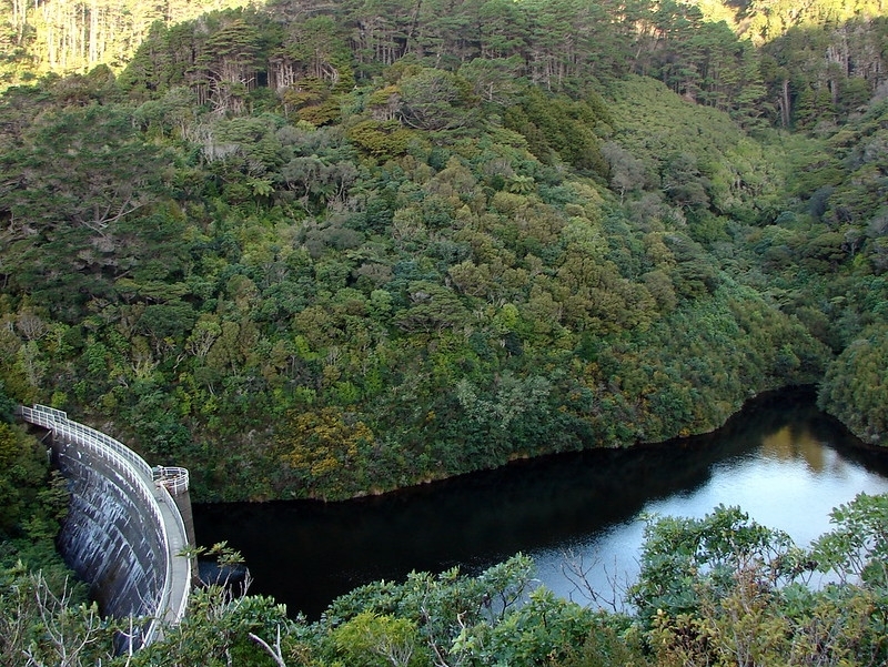
Sign up to hear more
Get the latest heritage news, features and events delivered
straight to your inbox.
