

This area is of outstanding archaeological, cultural, historical, and traditional significance due to its association with the early Maori inhabitants of the South Island, the Maori cultural values associated with it, especially in relation to the Ngai Tahu Whanui. The archaeological rarity of the site, the unique and outstanding nature of the art work that remains in-situ is of significant importance to Maori, and to all New Zealanders.

List Entry Information
Status
Listed
List Entry Status
Historic Area
Access
Private/No Public Access
List Number
7770
Date Entered
27th June 2008
Date of Effect
27th June 2008
City/District Council
Waitaki District
Region
Canterbury Region
Extent of List Entry
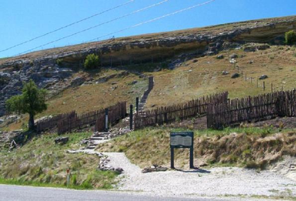
Extent includes the land described as Pt Sec 68 Blk III Maerewhenua Survey District (RT OT 221620) Otago Land District, Sec 72 Blk III Maerewhenua Survey District (RT OT19C/231) Otago Land District & Secs 73-74 Blk III Maerewhenua Survey District (RT OT 7B/1471) Otago Land District, and includes the registered historic places, all named 'Rock Shelter', Record numbers 5654-5662.. The historic places on the land included in this registration are inter-related as they are places which provide evidence of the Maori occupation, and movement through the Waitaki region. It can not be ascertained if any of the places are contemporaneous with each other, but physical remains and technical similarities provide evidence of inter-relatedness. These places are also regarded by the associated Runanga as constituent parts of what makes this site of high Maori heritage value. The historic area is physically and visually defined by extensive landscaping, fencing, and interpretive signage that has been installed by the Ngai Tahu Maori Rock Art Trust, on behalf of the wider Ngai Tahu Whanui. These developments provide information for visitors to assist in developing a greater understanding of the values associated with the site. The landscaping developments correlate to the sites within this historic area that are accessible to the public for visiting, and as some of these sites are not intended for public viewing, these places are not marked out, and generally require liaison with the Ngai Tahu Maori Rock Art Trust in order to visit.
Legal description
Pt Sec 68 Blk III Maerewhenua SD (RT OT 221620), Sec 72 Blk III Maerewhenua SD (RT OT19C/231) & Secs 73-74 Blk III Maerewhenua SD (RT OT7B/1471), Otago Land District.
Status
Listed
List Entry Status
Historic Area
Access
Private/No Public Access
List Number
7770
Date Entered
27th June 2008
Date of Effect
27th June 2008
City/District Council
Waitaki District
Region
Canterbury Region
Extent of List Entry
Extent includes the land described as Pt Sec 68 Blk III Maerewhenua Survey District (RT OT 221620) Otago Land District, Sec 72 Blk III Maerewhenua Survey District (RT OT19C/231) Otago Land District & Secs 73-74 Blk III Maerewhenua Survey District (RT OT 7B/1471) Otago Land District, and includes the registered historic places, all named 'Rock Shelter', Record numbers 5654-5662.. The historic places on the land included in this registration are inter-related as they are places which provide evidence of the Maori occupation, and movement through the Waitaki region. It can not be ascertained if any of the places are contemporaneous with each other, but physical remains and technical similarities provide evidence of inter-relatedness. These places are also regarded by the associated Runanga as constituent parts of what makes this site of high Maori heritage value. The historic area is physically and visually defined by extensive landscaping, fencing, and interpretive signage that has been installed by the Ngai Tahu Maori Rock Art Trust, on behalf of the wider Ngai Tahu Whanui. These developments provide information for visitors to assist in developing a greater understanding of the values associated with the site. The landscaping developments correlate to the sites within this historic area that are accessible to the public for visiting, and as some of these sites are not intended for public viewing, these places are not marked out, and generally require liaison with the Ngai Tahu Maori Rock Art Trust in order to visit.
Legal description
Pt Sec 68 Blk III Maerewhenua SD (RT OT 221620), Sec 72 Blk III Maerewhenua SD (RT OT19C/231) & Secs 73-74 Blk III Maerewhenua SD (RT OT7B/1471), Otago Land District.
Why is this place significant?
Cultural Significance
The Maerewhenua Historic Area is significant for a number of cultural reasons. It is primarily important to the Kaitiaki Runanga, Te Runanga o Moeraki, and to the Ngai Tahu Whanui as a whole, as a place inhabited by their ancestors in the past. For this reason it is of the highest importance in a cultural sense. This historic area is a landmark that contributes to the identity of the Ngai Tahu people, and they are active guardians of this area. Traditional stories associated with this site also form relationships with North Island iwi such as Ngati Porou in regards to stories associated with the waka Arai-Te-Uru, and the ancestor of the Ngai Tahu people - Tahupotiki, and Waikato iwi and Ngati Kahungungu, in regards to stories associated with Tamatea-Pokai-Whenua.
Physical Significance
KEY PHYSICAL DATES: Pre 1600 - Occupation by Maori of this site Post 1770 - Occupation by Maori of this site 1896 - Documentation by Augustus Hamilton ARCHAEOLOGICAL SIGNIFICANCE AND VALUE: The Maerewhenua Historic Area is of outstanding archaeological value that is of national significance. The historic area is valuable in terms of scientific research, as it has the potential to further contribute to the current body of knowledge relating to the rock art and archaeology in New Zealand. The Maerewhenua Historic Area also has significant scientific value as an important reference site for researchers and students. This historic area contains one of the few rock art sites accessible to the public in New Zealand.
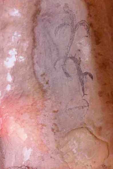
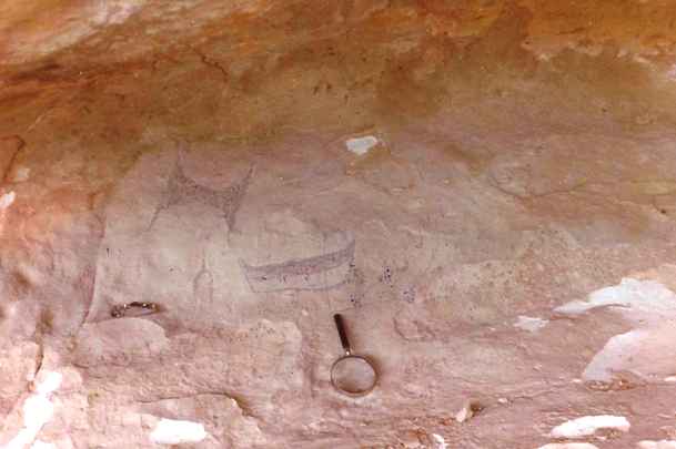
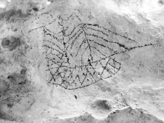
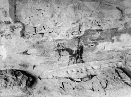
TRADITIONAL HISTORY: The Maerewhenua Historic Area is a significant landmark in the traditions of the Ngai Tahu Whanui. The dominant feature of this historic area is a rock shelter that lies on an ancient pathway near the Waitaki River between the mountains and the sea. The nearby Maerewhenua river feeds directly into the Waitaki. The headwaters of the Waitaki River are fed by ka roimata o Aoraki - the tears of Aoraki - the ancestral mountain of Ngai Tahu. The people of Ngai Tahu are descended from Aoraki - the most sacred of their ancestors - who was the first child of Raki (the Heavens) and Poharua Te Po (the breath of life found in the womb of darkness). Some of the earliest traditional accounts associated with human inhabitation of the lower South Island are connected to the voyaging waka named Arai-Te-Uru. Rongo-i-tua was a voyager from Hawaiki who introduced kumara to the Kahui-tipua people of the South Island. The Kahui-tipua people assisted Rongo-i-tua in the construction of a canoe in order for him to return to Hawaiki and secure additional Kumara for cultivation in the south (Stack 1879:159). On its return to the South Island, the Arai-Te-Uru encountered a fierce storm, and according to J. Herries Beattie's retelling of collected accounts, the crew member named Moko-tere-a-tarehu was lost overboard at the mouth of the Waitaki River (Beattie 2001:26). The canoe was blown further down the east coast of the South Island, and after losing much of its cargo of kumara at the beach known as Kai-hinaki (near Moeraki), the waka was wrecked at Matakaea (Shag Point) where it lies petrified in the landscape (Evans 1997:25). A. W. Reed's Treasury of Maori Exploration also notes that a waka named Arai-Te-Uru carried a sacred fire from Hawaiki known as Te Ahi-Tapu-a-Uenuku. This fire was buried along the Waikato River (Beattie 1994:435). This sacred fire was dug up by the great Maori explorer Tamatea-Pokai-Whenua prior to his circumnavigation of Aotearoa New Zealand aboard the waka Takitimu. This tradition asserts that limestone outcrops such as the one featured within the boundaries of this historic area are the legacy of Tamatea-Pokai-Whenua. During his exploration he traversed the land, using this sacred flame for making fire as he went; as the fires cooled, mounds of pale white ash were left in their place, which became the limestone features that are so prominent in the landscape of this region. In Johannes Andersen's discussion of the voyage of the Takitimu in his Maori Place Names, Andersen notes that Tamatea-Pokai-Whenua journeyed along the Waitaki River, and near the river: '...he cut out a cave for a house, which he ornamented with carvings and paintings. He cut out this cave in order to preserve the tuhutuhi (writing) which was brought from Irihia (beyond Hawaiki) by Uru-whenua and his three brothers.' (Andersen 2000:185) EARLY HISTORY: Both iwi history and archaeological evidence show occupation by Maori in the area over an extended period, with the inhabitants utilising a wide variety of natural resources from the diverse environment of the Waitaki River catchment. The date of earliest Polynesian settlement of the Waitaki area remains unknown, but is generally thought to date from at least 1,000 years ago (Symon 2007:8). There was extensive settlement throughout the Waitaki Valley when the moa existed, as shown in the widespread archaeological remains of moa bones in cultural contexts. GEOGRAPHICAL CONTEXT: The Maerewhenua Historic Area contains historic places which can be considered as part of chain of moa-hunter period sites recorded in the Waitaki Valley stretching from Korotuaheka at the river mouth, to the rock art sites at Kokoamo and here at Maerewhenua, on to Otakaroa, and to the sites at the junction of the Upper Waitaki with Shepherd's Creek and the Ahuriri River. EVIDENCE OF OCCUPATION: While the traditional ways of Maori life had been influenced to some extent by exotic elements by the mid 19th century, many of the old ways still flourished, and valuable insights are available from surveyors and missionaries records made while travelling through the area in the 1840s. On January 9th 1844 Edward Shortland noted 'a ruined hut and a cultivation ground (at) a small glen in the hills, where there was plenty of wood and a stream of water' (Shortland 1852:196) at nearby Papakaio, also on what is now State Highway 83. The following day his group walked to Te Puna a Maru, then the next day established a camp on the banks of the river several miles downstream. On October the 17th, 1845, the reverend Charles Creed travelled along the north bank of the river to the vicinity of Te Puna a Maru, staying at a settlement on the north bank, but giving no other details (Stevenson 1947:123). Mantell described a kaika on the south bank about seven miles inland from Tauhinu on the north bank (almost certainly Te Puna a Maru) as having 'well stored watas and four or five broken mokihi' (Stevenson 1947:128). No one was present at the time, as was often the case, although belongings were left in readiness for the expected return. Since the European occupation of the Maerewhenua area first began in the 1854, the area surrounding the Maerewhenua Historic Area has been used for pastoral purposes. Stevenson describes the area between the Maerewhenua outcrop and the river as previously being covered by ‘a dense growth of flax and toe-toe' with ‘an abundance of food in the vicinity' (Stevenson 1947:19-21). This has now been replaced with pasture and exotic trees such as willow and poplar, with a thick band of African boxthorn growing immediately in front of the lower Maerewhenua shelters. The land in front of the rock shelters has also been altered through the creation of the Livingstone - Duntroon Road, and the Duntroon tip (since closed). EUROPEAN DOCUMENTATION: The first archaeological investigation of the Maerewhenua Historic Area took place when Augustus Hamilton visited the site and photographed the rock art located in the caged shelter in 1896. No excavation took place at Maerewhenua, and Hamilton's observations were limited to what he could see in a section of the talus slope in front of the site which had been exposed during the creation of drainage ditches for the road. ‘I was pleased to find many moa bones and broken and cut fragments of moa bone, and was fortunate enough to pick out from the bank a well-made bone fishhook-barb, dropped or lost - who shall say how long ago?' (Hamilton 1896:173). Hamilton's assistant in 1896 was North Otago historian G. B. Stevenson, who noted that a burial had been found in the ‘long cave' in the lower Maerewhenua shelter around 1900. He describes it thus: ‘A few centuries ago a man of some importance, maybe a rangatira, died hereabouts. He was buried in a grave in the long shelter, close to the wall of the cliff. The body was placed in the sitting position on a slab of rock and another slab was placed above the head. It was discovered by an authority on Maori customs who said that certain marks on the rock wall indicated the presence of a grave.' (Stevenson 1947:20). The South Island Maori Rock Art Project (SIMRAP) was established in the 1990s to undertake an extensive recording and documentation of rock art in the South Island. The project began with a pilot study of sites in the North Otago region, including the Maerewhenua rock art sites and associated archaeological sites. Allingham observed a variety of archaeological deposit in the floors of the lower shelters at Maerewhenua, including moa bone, fire-cracked rock, faunal material and artefacts. He describes the floor of the lower shelters as ‘rich with deposit', spanning several centuries from the early period of occupation of the area, judging from the style of art, and the presence of moa bone in a cultural context (Symon 2007:9) The New Zealand Archaeological Association site record forms yield little information on the registered historic places within this historic area. In the files for site I40/18 and 25 (which relate specifically to the upper shelters - the main caged shelter, and the shelter immediately to the south), no mention is made of the archaeology of the either site. However, the potential for archaeological deposit to be present is noted by Trotter in the site record forms for sites I40/14 and 15 in the lower shelters, and is substantiated by the observations of Hamilton, Allingham and Stevenson above. ROCK ART AND NEW ZEALAND ART: Maori rock art is also often regarded as the earliest New Zealand artwork, and the rock art sites of South Canterbury and North Otago have been described as ‘New Zealand' oldest art galleries' (Schoon 1947:6). Theo Schoon was employed by the Department of Internal Affairs in 1947 to document rock art, and this experience was formative in the development of his own art (Keith 2007:14). Other New Zealand artists have been influenced by their experience with Maori rock art; Gordon Walters also accompanied Schoon on visits to rock art sites (Thompson 1989: 52), and Tony Fomison was involved in the recording of many sites and sketched the art at various sites extensively. The Ngai Tahu Artist Ross Hemera has often commented on the importance of the rock art in informing his work, stating ‘These drawings, for me, are manifestations of our tipuna. So when I go back to the rock shelters, when I'm visiting, these are the occasions when I feel closest to the spirit of my ancestors.' (Symon 2007).
TRADITIONAL HISTORY: The Maerewhenua Historic Area is a significant landmark in the traditions of the Ngai Tahu Whanui. The dominant feature of this historic area is a rock shelter that lies on an ancient pathway near the Waitaki River between the mountains and the sea. The nearby Maerewhenua river feeds directly into the Waitaki. The headwaters of the Waitaki River are fed by ka roimata o Aoraki - the tears of Aoraki - the ancestral mountain of Ngai Tahu. The people of Ngai Tahu are descended from Aoraki - the most sacred of their ancestors - who was the first child of Raki (the Heavens) and Poharua Te Po (the breath of life found in the womb of darkness). Some of the earliest traditional accounts associated with human inhabitation of the lower South Island are connected to the voyaging waka named Arai-Te-Uru. Rongo-i-tua was a voyager from Hawaiki who introduced kumara to the Kahui-tipua people of the South Island. The Kahui-tipua people assisted Rongo-i-tua in the construction of a canoe in order for him to return to Hawaiki and secure additional Kumara for cultivation in the south (Stack 1879:159). On its return to the South Island, the Arai-Te-Uru encountered a fierce storm, and according to J. Herries Beattie's retelling of collected accounts, the crew member named Moko-tere-a-tarehu was lost overboard at the mouth of the Waitaki River (Beattie 2001:26). The canoe was blown further down the east coast of the South Island, and after losing much of its cargo of kumara at the beach known as Kai-hinaki (near Moeraki), the waka was wrecked at Matakaea (Shag Point) where it lies petrified in the landscape (Evans 1997:25). A. W. Reed's Treasury of Maori Exploration also notes that a waka named Arai-Te-Uru carried a sacred fire from Hawaiki known as Te Ahi-Tapu-a-Uenuku. This fire was buried along the Waikato River (Beattie 1994:435). This sacred fire was dug up by the great Maori explorer Tamatea-Pokai-Whenua prior to his circumnavigation of Aotearoa New Zealand aboard the waka Takitimu. This tradition asserts that limestone outcrops such as the one featured within the boundaries of this historic area are the legacy of Tamatea-Pokai-Whenua. During his exploration he traversed the land, using this sacred flame for making fire as he went; as the fires cooled, mounds of pale white ash were left in their place, which became the limestone features that are so prominent in the landscape of this region. In Johannes Andersen's discussion of the voyage of the Takitimu in his Maori Place Names, Andersen notes that Tamatea-Pokai-Whenua journeyed along the Waitaki River, and near the river: '...he cut out a cave for a house, which he ornamented with carvings and paintings. He cut out this cave in order to preserve the tuhutuhi (writing) which was brought from Irihia (beyond Hawaiki) by Uru-whenua and his three brothers.' (Andersen 2000:185) EARLY HISTORY: Both iwi history and archaeological evidence show occupation by Maori in the area over an extended period, with the inhabitants utilising a wide variety of natural resources from the diverse environment of the Waitaki River catchment. The date of earliest Polynesian settlement of the Waitaki area remains unknown, but is generally thought to date from at least 1,000 years ago (Symon 2007:8). There was extensive settlement throughout the Waitaki Valley when the moa existed, as shown in the widespread archaeological remains of moa bones in cultural contexts. GEOGRAPHICAL CONTEXT: The Maerewhenua Historic Area contains historic places which can be considered as part of chain of moa-hunter period sites recorded in the Waitaki Valley stretching from Korotuaheka at the river mouth, to the rock art sites at Kokoamo and here at Maerewhenua, on to Otakaroa, and to the sites at the junction of the Upper Waitaki with Shepherd's Creek and the Ahuriri River. EVIDENCE OF OCCUPATION: While the traditional ways of Maori life had been influenced to some extent by exotic elements by the mid 19th century, many of the old ways still flourished, and valuable insights are available from surveyors and missionaries records made while travelling through the area in the 1840s. On January 9th 1844 Edward Shortland noted 'a ruined hut and a cultivation ground (at) a small glen in the hills, where there was plenty of wood and a stream of water' (Shortland 1852:196) at nearby Papakaio, also on what is now State Highway 83. The following day his group walked to Te Puna a Maru, then the next day established a camp on the banks of the river several miles downstream. On October the 17th, 1845, the reverend Charles Creed travelled along the north bank of the river to the vicinity of Te Puna a Maru, staying at a settlement on the north bank, but giving no other details (Stevenson 1947:123). Mantell described a kaika on the south bank about seven miles inland from Tauhinu on the north bank (almost certainly Te Puna a Maru) as having 'well stored watas and four or five broken mokihi' (Stevenson 1947:128). No one was present at the time, as was often the case, although belongings were left in readiness for the expected return. Since the European occupation of the Maerewhenua area first began in the 1854, the area surrounding the Maerewhenua Historic Area has been used for pastoral purposes. Stevenson describes the area between the Maerewhenua outcrop and the river as previously being covered by ‘a dense growth of flax and toe-toe' with ‘an abundance of food in the vicinity' (Stevenson 1947:19-21). This has now been replaced with pasture and exotic trees such as willow and poplar, with a thick band of African boxthorn growing immediately in front of the lower Maerewhenua shelters. The land in front of the rock shelters has also been altered through the creation of the Livingstone - Duntroon Road, and the Duntroon tip (since closed). EUROPEAN DOCUMENTATION: The first archaeological investigation of the Maerewhenua Historic Area took place when Augustus Hamilton visited the site and photographed the rock art located in the caged shelter in 1896. No excavation took place at Maerewhenua, and Hamilton's observations were limited to what he could see in a section of the talus slope in front of the site which had been exposed during the creation of drainage ditches for the road. ‘I was pleased to find many moa bones and broken and cut fragments of moa bone, and was fortunate enough to pick out from the bank a well-made bone fishhook-barb, dropped or lost - who shall say how long ago?' (Hamilton 1896:173). Hamilton's assistant in 1896 was North Otago historian G. B. Stevenson, who noted that a burial had been found in the ‘long cave' in the lower Maerewhenua shelter around 1900. He describes it thus: ‘A few centuries ago a man of some importance, maybe a rangatira, died hereabouts. He was buried in a grave in the long shelter, close to the wall of the cliff. The body was placed in the sitting position on a slab of rock and another slab was placed above the head. It was discovered by an authority on Maori customs who said that certain marks on the rock wall indicated the presence of a grave.' (Stevenson 1947:20). The South Island Maori Rock Art Project (SIMRAP) was established in the 1990s to undertake an extensive recording and documentation of rock art in the South Island. The project began with a pilot study of sites in the North Otago region, including the Maerewhenua rock art sites and associated archaeological sites. Allingham observed a variety of archaeological deposit in the floors of the lower shelters at Maerewhenua, including moa bone, fire-cracked rock, faunal material and artefacts. He describes the floor of the lower shelters as ‘rich with deposit', spanning several centuries from the early period of occupation of the area, judging from the style of art, and the presence of moa bone in a cultural context (Symon 2007:9) The New Zealand Archaeological Association site record forms yield little information on the registered historic places within this historic area. In the files for site I40/18 and 25 (which relate specifically to the upper shelters - the main caged shelter, and the shelter immediately to the south), no mention is made of the archaeology of the either site. However, the potential for archaeological deposit to be present is noted by Trotter in the site record forms for sites I40/14 and 15 in the lower shelters, and is substantiated by the observations of Hamilton, Allingham and Stevenson above. ROCK ART AND NEW ZEALAND ART: Maori rock art is also often regarded as the earliest New Zealand artwork, and the rock art sites of South Canterbury and North Otago have been described as ‘New Zealand' oldest art galleries' (Schoon 1947:6). Theo Schoon was employed by the Department of Internal Affairs in 1947 to document rock art, and this experience was formative in the development of his own art (Keith 2007:14). Other New Zealand artists have been influenced by their experience with Maori rock art; Gordon Walters also accompanied Schoon on visits to rock art sites (Thompson 1989: 52), and Tony Fomison was involved in the recording of many sites and sketched the art at various sites extensively. The Ngai Tahu Artist Ross Hemera has often commented on the importance of the rock art in informing his work, stating ‘These drawings, for me, are manifestations of our tipuna. So when I go back to the rock shelters, when I'm visiting, these are the occasions when I feel closest to the spirit of my ancestors.' (Symon 2007).
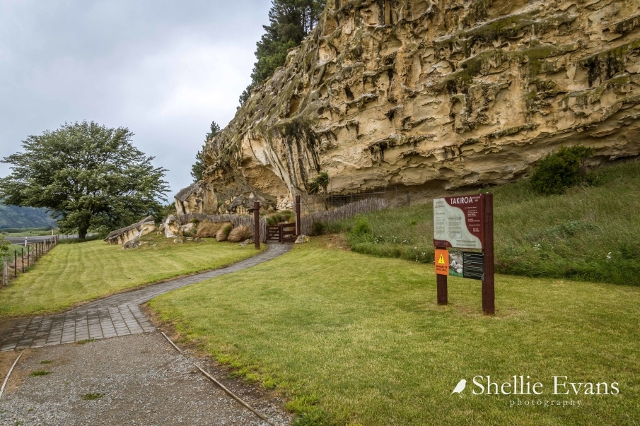
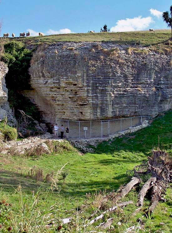
Physical Description and Analysis: Land included in the Registration: The land included in this registration is an inter-related group of places that are part of the historical and cultural heritage of New Zealand. This historic area registration is a single contiguous area which possesses archaeological, cultural, spiritual, and traditional significance and values. The area consists of a steeply sloped grassed area of land (that provides access to view Historic Place Number 5662), a semi-enclosed caged rock shelter (Historic Place Number 5662), an adjacent, uncaged rock shelter (South Rock Shelter, unregistered), and a near vertical limestone rock face. The area is defined at its south western edge by landscaped steps, a large interpretive panel, and three semi-carved pou (tall posts) with interpretation information about the rock art site. The land included in this registration includes both registered and unregistered historic places. Historic Places on Land included in the Registration South Rock Shelter, unregistered Rock Shelter, Record Number 5654 Rock Shelter, Record Number 5655 Rock Shelter, Record Number 5656 Rock Shelter, Record Number 5657 Rock Shelter, Record Number 5658 Rock Shelter, Record Number 5659 Rock Shelter, Record Number 5660 Rock Shelter, Record Number 5661 Rock Shelter, Record Number 5662 Relationship between Historic Places The historic places on the land included in this registration are inter-related as they are places which provide evidence of the Maori occupation, and movement through the Waitaki region. It can not be ascertained if any of the places are contemporaneous with each other, but physical remains and technical similarities provide evidence of inter-relatedness. These places are also regarded by the associated Runanga as constituent parts of what makes this site of high Maori heritage value. Key Elements of the Historic Area: The historic area is physically and visually defined by extensive landscaping, fencing, and interpretive signage that has been installed by the Ngai Tahu Maori Rock Art Trust, on behalf of the wider Ngai Tahu Whanui. These developments provide information for visitors to assist in developing a greater understanding of the values associated with the site. The landscaping developments correlate to the sites within this historic area that are accessible to the public for visiting, and as some of these sites are not intended for public viewing, these places are not marked out, and generally require liaison with the Ngai Tahu Maori Rock Art Trust in order to visit.
Physical Description and Analysis: Land included in the Registration: The land included in this registration is an inter-related group of places that are part of the historical and cultural heritage of New Zealand. This historic area registration is a single contiguous area which possesses archaeological, cultural, spiritual, and traditional significance and values. The area consists of a steeply sloped grassed area of land (that provides access to view Historic Place Number 5662), a semi-enclosed caged rock shelter (Historic Place Number 5662), an adjacent, uncaged rock shelter (South Rock Shelter, unregistered), and a near vertical limestone rock face. The area is defined at its south western edge by landscaped steps, a large interpretive panel, and three semi-carved pou (tall posts) with interpretation information about the rock art site. The land included in this registration includes both registered and unregistered historic places. Historic Places on Land included in the Registration South Rock Shelter, unregistered Rock Shelter, Record Number 5654 Rock Shelter, Record Number 5655 Rock Shelter, Record Number 5656 Rock Shelter, Record Number 5657 Rock Shelter, Record Number 5658 Rock Shelter, Record Number 5659 Rock Shelter, Record Number 5660 Rock Shelter, Record Number 5661 Rock Shelter, Record Number 5662 Relationship between Historic Places The historic places on the land included in this registration are inter-related as they are places which provide evidence of the Maori occupation, and movement through the Waitaki region. It can not be ascertained if any of the places are contemporaneous with each other, but physical remains and technical similarities provide evidence of inter-relatedness. These places are also regarded by the associated Runanga as constituent parts of what makes this site of high Maori heritage value. Key Elements of the Historic Area: The historic area is physically and visually defined by extensive landscaping, fencing, and interpretive signage that has been installed by the Ngai Tahu Maori Rock Art Trust, on behalf of the wider Ngai Tahu Whanui. These developments provide information for visitors to assist in developing a greater understanding of the values associated with the site. The landscaping developments correlate to the sites within this historic area that are accessible to the public for visiting, and as some of these sites are not intended for public viewing, these places are not marked out, and generally require liaison with the Ngai Tahu Maori Rock Art Trust in order to visit.
Historical and Associated Iwi / Hapū / Whānau
Iwi: Ngāi Tahu
Public NZAA Number
I40/10
Completion Date
13th June 2008
Report Written By
E Andersen
Information Sources
Andersen, 2000
J C Andersen, Maori Place Names, Cadsonbury Publications (reprint of 1942 ed.), Christchurch, 2000.
Anderson, 1998
Atholl Anderson, The Welcome of Strangers: An ethnohistory of southern Maori A.D. 1650-1850, Otago University Press in association with the Dunedin City Council, Dunedin, 1998
Anderson, 1989
Atholl Anderson, Prodigious Birds: Moas and moa-hunting in prehistoric New Zealand, Cambridge, 1989.
Beattie, 2001
JH Beattie, Maori Place-names of Otago, Cadsonbury Publications (reprint of 1944 Ed.), Christchurch, 2001.
Beattie, 1994
James Herries Beattie, Traditional Lifeways of the Southern Maori, Otago University Press, Otago, 1994.
Duff, 1956
Roger Duff, The Moa-Hunter Period of Maori Culture. Government Printer, Wellington, 1956.
Evans, 1997 (2)
J. Evans, Nga Waka o Nehera, the first voyaging canoes, Reed Publishers, Auckland, 1997.
Hamilton, 1896
Augustus Hamilton, 'Notes on Murihiku'. Transactions and Proceedings of the New Zealand Institute, Volume 19, 1896.
New Zealand Journal of Archaeology
New Zealand Journal of Archaeology
Reed, 1963
A W Reed, Treasury of Maori Folklore, A.H. and A.W. Reed, Wellington, 1963.
Shortland, 1852
E Shortland, The Southern Districts of New Zealand, Longman, Brown, Green and Longmans, London, 1852.
Stevenson, 1947
G B Stevenson, Maori and Pakeha in North Otago, A.H. & A.W.Reed, Wellington, 1947
Trotter, 1981
M Trotter and B McCulloch, Prehistoric Rock Art of New Zealand, Longman Paul Ltd, Auckland, 1981.
Hamel, 2001
Jill Hamel, The Archaeology of Otago, Department of Conservation, Wellington, 2001
Transactions and Proceedings of the New Zealand Institute
Transactions and Proceedings of the New Zealand Institute
Other Information
A fully referenced Registration Report is available from the Maori Heritage Team of the National Office in Wellington. Relationship between Historic Places: The historic places on the land included in this registration are inter-related as they are places which provide evidence of the Maori occupation, and movement through the Waitaki region. It can not be ascertained if any of the places are contemporaneous with each other, but physical remains and technical similarities provide evidence of inter-relatedness. These places are also regarded by the associated Runanga as constituent parts of what makes this site of high Maori heritage value. Key Elements of the Historic Area: The historic area is physically and visually defined by extensive landscaping, fencing, and interpretive signage that has been installed by the Ngai Tahu Maori Rock Art Trust, on behalf of the wider Ngai Tahu Whanui. These developments provide information for visitors to assist in developing a greater understanding of the values associated with the site. The landscaping developments correlate to the sites within this historic area that are accessible to the public for visiting, and as some of these sites are not intended for public viewing, these places are not marked out, and generally require liaison with the Ngai Tahu Maori Rock Art Trust in order to visit. Please note that entry on the New Zealand Heritage List/Rarangi Korero identifies only the heritage values of the property concerned, and should not be construed as advice on the state of the property, or as a comment of its soundness or safety, including in regard to earthquake risk, safety in the event of fire, or insanitary conditions.
Current Usages
Uses: Maori
Specific Usage: Cave/ rock shelter
Uses: Maori
Specific Usage: Rock art
Uses: Maori
Specific Usage: Site of mythological event/ traditional or cultural importance
Former Usages
General Usage: Cultural Landscape
Specific Usage: Ancestral landscape
General Usage: Maori
Specific Usage: Ara - pathway connecting tribal areas and resource sites
General Usage: Maori
Specific Usage: Cave/ rock shelter
General Usage: Maori
Specific Usage: Ceremonial site
General Usage: Maori
Specific Usage: Rock art
Themes
Of Significance to Maori
Location
Related listings


Sign up to hear more
Get the latest heritage news, features and events delivered
straight to your inbox.
