

The Mount Cook Road Board Building (Former) in Burkes Pass, constructed in 1875-6, is a legacy of the role of Burkes Pass in local government and is notable as an early concrete building in New Zealand. As a relatively rare surviving purpose-built road board building, it reflects New Zealand’s emphasis on road building since the colonial period.
The Mount Cook Road Board was one of four boards created in 1863 by the Canterbury Provincial Council, under The Road Districts Ordinance No. 1. It acted as an early local authority, collecting money to pay for road building and maintenance. Initially the Mount Cook Road Board meetings were held in private homes, public houses and stores but eventually a purpose-built office was designed by Timaru architect Daniel West in 1875. The first meeting of the Board in their new Burkes Pass building was held on 6 June 1876.
Compared to other buildings in Burkes Pass at the time, which were more modest and built of timber or cob, the Mount Cook Road Board Building (Former) is a comparatively large concrete building in the small town and comprises two distinct single-storeyed wings. Its slightly unusual style reflects the building’s combined function, both as the Road Board Office and residence. The main rectangular wing forms the southern two-thirds of the building and is a four roomed cottage with a hipped roof and a slightly sloping verandah on its east elevation. Except for its grand double doors and wide corridor, it is largely domestic in appearance. Immediately abutting the north side of, and running perpendicular to, the large rectangular wing is a narrower three roomed rectangular wing, also with a hipped roof, and with a prominent bay window at its eastern elevation. Both wings appear to have been built contemporaneously and have matching detailing such as concrete quoins and window sill brackets. Each wing has separate exterior access, with the southern wing doors being the grander, main entrance, to the building.
The Mount Cook Road Board evolved into the Mackenzie County Council. The Mackenzie County Council held its meetings in the building from 1883 until 1891, after which the council moved its premises to Fairlie. While it has always had some kind of residential function in its administrative role, since the early 1890s the building has functioned as housing for various families, including those associated with the Mackenzie Rabbit Board. Changes have been made to the building over time, including the erection of two gable roofed timber additions at the rear (west) side of the building and, in the 1950s, an internal division to create two separate living areas.
The Mount Cook Road Board was one of four boards created in 1863 by the Canterbury Provincial Council, under The Road Districts Ordinance No. 1. It acted as an early local authority, collecting money to pay for road building and maintenance. Initially the Mount Cook Road Board meetings were held in private homes, public houses and stores but eventually a purpose-built office was designed by Timaru architect Daniel West in 1875. The first meeting of the Board in their new Burkes Pass building was held on 6 June 1876.
Compared to other buildings in Burkes Pass at the time, which were more modest and built of timber or cob, the Mount Cook Road Board Building (Former) is a comparatively large concrete building in the small town and comprises two distinct single-storeyed wings. Its slightly unusual style reflects the building’s combined function, both as the Road Board Office and residence. The main rectangular wing forms the southern two-thirds of the building and is a four roomed cottage with a hipped roof and a slightly sloping verandah on its east elevation. Except for its grand double doors and wide corridor, it is largely domestic in appearance. Immediately abutting the north side of, and running perpendicular to, the large rectangular wing is a narrower three roomed rectangular wing, also with a hipped roof, and with a prominent bay window at its eastern elevation. Both wings appear to have been built contemporaneously and have matching detailing such as concrete quoins and window sill brackets. Each wing has separate exterior access, with the southern wing doors being the grander, main entrance, to the building.
The Mount Cook Road Board evolved into the Mackenzie County Council. The Mackenzie County Council held its meetings in the building from 1883 until 1891, after which the council moved its premises to Fairlie. While it has always had some kind of residential function in its administrative role, since the early 1890s the building has functioned as housing for various families, including those associated with the Mackenzie Rabbit Board. Changes have been made to the building over time, including the erection of two gable roofed timber additions at the rear (west) side of the building and, in the 1950s, an internal division to create two separate living areas.
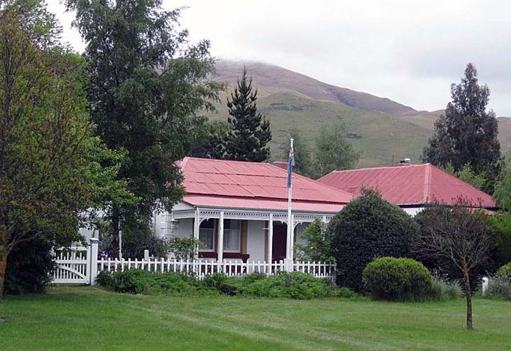
Mount Cook Road Board Building (Former) | R Burgess | 17/11/2014 | Heritage New Zealand Pouhere Taonga
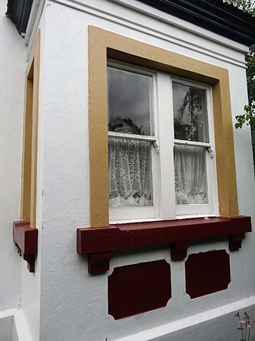
Mount Cook Road Board Building (Former). Detail, bay window on east elevation of north-east wing | R Burgess | 17/11/2014 | Heritage New Zealand Pouhere Taonga
Mount Cook Road Board Building (Former) | R Burgess | 17/11/2014 | Heritage New Zealand Pouhere Taonga
Mount Cook Road Board Building (Former). Detail, bay window on east elevation of north-east wing | R Burgess | 17/11/2014 | Heritage New Zealand Pouhere Taonga
