

The Mount Cook Road Board was one of four boards created in 1863 by the Canterbury Provincial Council, under The Road Districts Ordinance No. 1. It acted as an early local authority, collecting money to pay for road building and maintenance. Initially the Mount Cook Road Board meetings were held in private homes, public houses and stores but eventually a purpose-built office was designed by Timaru architect Daniel West in 1875. The first meeting of the Board in their new Burkes Pass building was held on 6 June 1876.
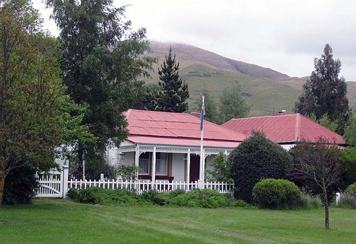
Compared to other buildings in Burkes Pass at the time, which were more modest and built of timber or cob, the Mount Cook Road Board Building (Former) is a comparatively large concrete building in the small town and comprises two distinct single-storeyed wings. Its slightly unusual style reflects the building’s combined function, both as the Road Board Office and residence. The main rectangular wing forms the southern two-thirds of the building and is a four roomed cottage with a hipped roof and a slightly sloping verandah on its east elevation. Except for its grand double doors and wide corridor, it is largely domestic in appearance. Immediately abutting the north side of, and running perpendicular to, the large rectangular wing is a narrower three roomed rectangular wing, also with a hipped roof, and with a prominent bay window at its eastern elevation. Both wings appear to have been built contemporaneously and have matching detailing such as concrete quoins and window sill brackets. Each wing has separate exterior access, with the southern wing doors being the grander, main entrance, to the building.
The Mount Cook Road Board evolved into the Mackenzie County Council. The Mackenzie County Council held its meetings in the building from 1883 until 1891, after which the council moved its premises to Fairlie. While it has always had some kind of residential function in its administrative role, since the early 1890s the building has functioned as housing for various families, including those associated with the Mackenzie Rabbit Board. Changes have been made to the building over time, including the erection of two gable roofed timber additions at the rear (west) side of the building and, in the 1950s, an internal division to create two separate living areas.
List Entry Information
Status
Listed
List Entry Status
Historic Place Category 2
Access
Private/No Public Access
List Number
9527
Date Entered
30th April 2015
Date of Effect
29th May 2015
City/District Council
Mackenzie District
Region
Canterbury Region
Extent of List Entry
Extent includes the land described as Lot 1 DP 29679 (RT CB11F/425), Canterbury Land District and the building known as Mount Cook Road Building (Former) thereon. (Refer to map in Appendix 1 of the List entry report for further information).
Legal description
Lot 1 DP 29679 (RT CB11F/425), Canterbury Land District
Why is this place significant?
Historic Significance
Historical Significance or Value The Mount Cook Road Board Building (Former) has historical significance. It was part of the evolution of local government in New Zealand. Built in 1875-6, it is an early concrete building in New Zealand and the earliest administration building for the Mackenzie District. It reminds us of the central importance of roading infrastructure in the pioneering days of European settlement. The building became the first headquarters of the Mount Cook Road Board, the first local government in Mackenzie.
Physical Significance
Architectural Significance or Value The Mount Cook Road Board Building (Former) has architectural value in the small township of Burkes Pass as a comparatively large, architecturally designed, concrete building compared with other more modest buildings nearby, such as the cob cottage and small timber dwellings. Its design, plan and materials were intended to convey the impression of wealth, prosperity and importance. The style of the building is somewhat unusual in that it combines traits commonly associated with residential buildings with characteristics found in commercial or public buildings, such as the heavy double main doors and dual entrance. Technological Significance or Value The Mount Cook Road Board Building (Former) has technological value as a relatively intact concrete building constructed, in the mid 1870s, at a time when the use of concrete for full construction was still in its infancy in New Zealand. Concrete became an important construction material in New Zealand and its use ever since the mid nineteenth century forms part of our cultural heritage.
Why is this place Category 1 / Category 2?
Detail Of Assessed Criteria
(a) The extent to which the place reflects important or representative aspects of New Zealand history The Mount Cook Road Board Building (Former) is a surviving purpose-built road board building, reflecting an early era of local government and serving to demonstrate how important roads and associated infrastructure were to the country’s disparate settlements. The building reflects the importance of transport links to the development of New Zealand. As with other districts, the local road board and, later, county council had an important role as local government and was a significant employer in the district. (g) The technical accomplishment, value, or design of the place The Mount Cook Road Board Building (Former) has technological value for being built of concrete in the 1870s, a decade when this type of construction was still only developing in New Zealand. (j) The importance of identifying rare types of historic places The Mount Cook Road Board Building (Former) has some rarity value both as an example of a surviving mid 1870s building constructed of concrete and as a road board building, a type that was once relatively common and now has a considerably reduced number surviving. It is not clear exactly how many road board buildings were purpose-built in the nineteenth century. Although there were over 300 road boards in the 1880s, not all would have required their own office and many operated out of other existing, or multi-purpose, buildings. There appear to be few surviving purpose-built road board buildings that date from the early era of road boards and of those that are known, most appear to be relatively small and constructed of timber. The Mount Cook Road Board Building (Former), in contrast, is notable for being comparatively larger and built of the permanent material of concrete. While other concrete buildings were constructed in New Zealand earlier than the Mount Cook Road Board Building (Former), some potentially even a decade earlier, nevertheless the 1875-6 date for the building means that belongs to a group of somewhat rare surviving early concrete buildings. Summary of Significance or Values The Mount Cook Road Board Building (Former) has significance as a largely intact purpose-built early road board building. Representing an early era of local government, it serves to demonstrate how important roads and associated infrastructure were to the country’s disparate settlements. It is notable also as being an early concrete building in New Zealand.
Construction Professional
Name
Foden, Thomas
Type
Builder
Biography
No biography is currently available for this construction professional
Name
West, Daniel
Type
Architect
Biography
No biography is currently available for this construction professional
Construction Details
Type
Addition
Description
Addition of two timber wings at the west rear of the building.
Period
1950s
Start Year
1875
Finish Year
1876
Type
Original Construction
Construction Materials
Concrete, timber, corrugated iron, brick
Māori History of the Area The central location of Te Manahuna (Mackenzie Basin) within Te Waipounamu meant Ngāi Tahu hapū from all over the eastern and southern seaboards of Te Waipounamu undertook seasonal mahinga kai expeditions to Te Manahuna over a variety of ara tawhito (traditional travel routes). Te Kopi o Opihi (Burkes Pass) ara tawhito was the principal travel route from the Arowhenua region to Te Manahuna. This trail followed the river from the mouth of the Opihi River over Te Kopi o Opihi into Te Manahuna. Lakes Pūkaki, Tekapo, Taka-moana (Alexandrina) and Whakarukumoana (Macgregor) as well as Te Manahuna itself were well known mahinga kai areas with an abundance of weka and tuna. These resources were particularly targeted during May to August to take advantage of the fat content as part of the preservation process. Burkes Pass Burkes Pass itself was named after Canterbury settler, Michael John Burke, who is claimed to have been the first Pākehā to have ‘discovered’ the pass to the Mackenzie Basin in 1855. The discovery of the vast Mackenzie plain resulted in ‘gold rush’ and ‘land rush’ selectors literally racing to the Land office in Christchurch to register claims and by 1858 vast areas of land had been applied for and taken up. The need for a township near the pass was recognised by the Canterbury Provincial Government in 1859 and 640 acres (259 hectares) was reserved for one between the summit of Burkes Pass and Stericker's Mound. However, the township of Burkes Pass grew up instead around the first accommodation house on what was then known as Cabbage Tree Flat, located in a more sheltered spot than the reserved land. By early 1877, a small village had established in Burkes Pass and it was expected the settlement would continue to grow as the administrative centre of the Mackenzie Basin. As the area opened up, roads were required for horse-drawn vehicles. A dray track and later a road was cut through the pass and it became the main route for travellers into the Mackenzie Country. As the roads were formed and the Mackenzie Country prospered, Burkes Pass became the social, business and sporting centre for Mackenzie Country pioneers. Roading In New Zealand there was little public road construction prior to the 1840s and 1850s. The earliest road boards were formed in the late 1850s, acting as early local authorities who could collect money to pay for road building and maintenance. To begin with, construction and maintenance of civilian roads were the responsibility of provincial governments. After 1876, when the provincial government system was abolished, road boards, and later county councils which took over their role, did most road building and maintenance. In the Mackenzie Country, increasing agricultural activity from 1874 to 1883 resulted in the rapid development of country roads. Many of these roads were shingled to allow horse and buggy traffic. Mount Cook Road Board In Canterbury, the Mount Cook Road Board was one of four boards created by the Canterbury Provincial Council, under The Road Districts Ordinance No. 1, in 1863. Initially the Board had no offices and so meetings were held in private homes and hotels, and furniture was packed in and out of a large tin box at the start and finish of each meeting. The first meeting was held on 15 April 1864 at Sawdon Station, overlooking Burkes Pass, and Frederick Teschmaker was Chair. The next five meetings were also held at Sawdon Station. Many meetings were held at the accommodation house, variously named Burgess’s, Stansell’s and Walley’s. Others were held nearby at Rollesby Station, Ashwick Station, Three Springs Station, Brown & Maude’s, Mathias and Ensors, and Spalding’s Store. Some meetings were even held in Timaru. Eventually it was time for a purpose-built office, and land at Burkes Pass was chosen. In early 1875, the Board approached Timaru architect, Daniel West, to draw plans and estimates for a Road Board office. West promptly worked on the plans and in April 1875 submitted an estimated cost of building an office for the Mount Cook Road Board according to plan for about £1050. This was for a building of stone construction, but it was decided to put the building project on hold, as it was considered impossible to build in such material over winter. The Board subsequently reconsidered the choice of building material and sought tenders for building in either stone or concrete. By late October 1875, a tender from Thomas Foden, builder, was accepted. As sought, Foden provided the Board with separate prices for stone (£896/3/-) and concrete (£814/5/-), and it opted for concrete. A clerk of works was engaged for the construction, his duties included ensuring that the proper amount of cement was put into the concrete mixture. Work on the new building appears to have been under way by late December 1875, with special attention given to the foundations. By April 1876, it was near completion and arrangements were made to furnish the building and have a verandah and stables constructed. The first meeting of the Board in the new building was held on 6 June 1876, with Frederick [Fred] J Kimbell as chairman. A visitor to Burkes Pass in 1877 described the building as a ‘handsome-looking concrete house’ that served as both the Mount Cook Road Board office and the residence of George Clulee, secretary and overseer to the board. As the administrative centre for the district, a wide range of matters were dealt with from the building. Roads, bridges and rates were a major focus. The administrative functions of the Board would have meant it would have needed offices and storage. An engineer was based in the building for at least 10 days a month. The building also served as a polling place, assessment court and meeting venue. Public meetings as well as board meetings were held in the building. With its large bay window and timber ceiling, the north-east room of the building may have been the boardroom. The building also functioned as the residence of various administrators associated with the board, with George Clulee being one of its earliest occupants. Advertisements for an overseer to the board outline that coals, a house and stables would be provided to the successful applicant. The Mount Cook Road Board was a significant employer in the district. It frequently put contract work out to tender, notably for roads and structures such as buildings and bridges. It was also responsible for contracting out specific projects such as reconstructing the Pūkaki River punt, building the Lake Tekapo ferry and ferryman’s house, mapping of the road district, and carrying out rating valuations. In 1880, they reported that, ‘for years the Mount Cook Road Board has, on an average, expended £1300 to £1400 monthly on local works, and has, through the medium of contractors, given employment to between 250 and 300 men constantly’, including otherwise unemployed men from the district. This is a large number, given that the population of Burkes Pass was less than 100 at the time. The Mackenzie County Council was created in place of the road board on 1 October 1883. The first meeting of the Mackenzie County Council was held in the former road board building on 3 December 1883, with John McGregor as chairman. An often discussed problem in the district was the ‘rabbit menace’. Roading infrastructure continued to be a key focus. In addition, a railway had been proposed to terminate at Burkes Pass, which would have enabled it to be the distributing centre for the Mackenzie Basin. However, the latter never eventuated, as the railway extended only as far as Fairlie (approximately 16 miles or 26 kilometres away). Occasionally, visitors commented on the building being a feature in a town that contained only about a dozen houses, union church, school, store, smithy and a hotel. As the Mackenzie County Council offices, the Mount Cook Road Board Building (Former) continued in the 1880s to be the hub of local authority-related activity and had a high profile. In 1891, the board held its last meeting in the building and voted to relocate to Fairlie, which had displaced Burkes Pass as the business centre for the Mackenzie District. This transfer of the county office from Burkes Pass to Fairlie on 25 November 1891 changed the pattern of existence for both places. Later uses of the building On 14 November 1892, the Mackenzie County Council accepted Councillor Andrew Cowan’s tender of £26/10/- to lease the building at Burkes Pass. In May 1901, Mrs David Gunn took over, and in September 1902 Mr Malcolm McLeod leased the building. Mr Cowan again had it for a time until 1904 when Mr Donald Ross, Burkes Pass sheep farmer, took over. Mr Ross eventually purchased the property for £550 in 1920. Several families lived in the building until the late 1950s. Tom and Annie McCarthy rented and lived there with their three children for several years from 1936. Jimmy and Bella Whyte bought and lived in the property from 1946. In the 1950s the building was converted into two living spaces, each with their own bathroom and kitchen. One of the families living there at this time was the Grimwood family, associated with the Mackenzie Rabbit Board, which had been formed in 1935. From the late 1950s until 1961 the building was used to house the single men of the Mackenzie Rabbit Board. During this time the building was used as a gathering place by rabbit board staff, who used it as an extension of the Burkes Pass Hotel in the days when the pub had to close at 6.00 pm. In the early 1960s Noel and Molly Samson lived in part of the house. In 1966, Maurice R J Angelo purchased the property from the Mackenzie Rabbit Board and, with his wife, Elizabeth (Liz), turned it into a private home and an artists’ retreat. During this almost 50 year period, the building was renovated and many people, including some well-known artists visited the property. In January 2011, the house hosted the first meeting of the year of the Mackenzie District Council, with councillors dressed in Victorian costume, to honour the building’s past. Shortly after, in early 2011, the Angelos sold to the present owners, who are continuing to restore the building. In the 2000s, the Burkes Pass Heritage Trust produced a brochure, the Burkes Pass Heritage Walk & Historic Village, which features the Mount Cook Road Board Building (Former) as one of the key features within the historic town.
Māori History of the Area The central location of Te Manahuna (Mackenzie Basin) within Te Waipounamu meant Ngāi Tahu hapū from all over the eastern and southern seaboards of Te Waipounamu undertook seasonal mahinga kai expeditions to Te Manahuna over a variety of ara tawhito (traditional travel routes). Te Kopi o Opihi (Burkes Pass) ara tawhito was the principal travel route from the Arowhenua region to Te Manahuna. This trail followed the river from the mouth of the Opihi River over Te Kopi o Opihi into Te Manahuna. Lakes Pūkaki, Tekapo, Taka-moana (Alexandrina) and Whakarukumoana (Macgregor) as well as Te Manahuna itself were well known mahinga kai areas with an abundance of weka and tuna. These resources were particularly targeted during May to August to take advantage of the fat content as part of the preservation process. Burkes Pass Burkes Pass itself was named after Canterbury settler, Michael John Burke, who is claimed to have been the first Pākehā to have ‘discovered’ the pass to the Mackenzie Basin in 1855. The discovery of the vast Mackenzie plain resulted in ‘gold rush’ and ‘land rush’ selectors literally racing to the Land office in Christchurch to register claims and by 1858 vast areas of land had been applied for and taken up. The need for a township near the pass was recognised by the Canterbury Provincial Government in 1859 and 640 acres (259 hectares) was reserved for one between the summit of Burkes Pass and Stericker's Mound. However, the township of Burkes Pass grew up instead around the first accommodation house on what was then known as Cabbage Tree Flat, located in a more sheltered spot than the reserved land. By early 1877, a small village had established in Burkes Pass and it was expected the settlement would continue to grow as the administrative centre of the Mackenzie Basin. As the area opened up, roads were required for horse-drawn vehicles. A dray track and later a road was cut through the pass and it became the main route for travellers into the Mackenzie Country. As the roads were formed and the Mackenzie Country prospered, Burkes Pass became the social, business and sporting centre for Mackenzie Country pioneers. Roading In New Zealand there was little public road construction prior to the 1840s and 1850s. The earliest road boards were formed in the late 1850s, acting as early local authorities who could collect money to pay for road building and maintenance. To begin with, construction and maintenance of civilian roads were the responsibility of provincial governments. After 1876, when the provincial government system was abolished, road boards, and later county councils which took over their role, did most road building and maintenance. In the Mackenzie Country, increasing agricultural activity from 1874 to 1883 resulted in the rapid development of country roads. Many of these roads were shingled to allow horse and buggy traffic. Mount Cook Road Board In Canterbury, the Mount Cook Road Board was one of four boards created by the Canterbury Provincial Council, under The Road Districts Ordinance No. 1, in 1863. Initially the Board had no offices and so meetings were held in private homes and hotels, and furniture was packed in and out of a large tin box at the start and finish of each meeting. The first meeting was held on 15 April 1864 at Sawdon Station, overlooking Burkes Pass, and Frederick Teschmaker was Chair. The next five meetings were also held at Sawdon Station. Many meetings were held at the accommodation house, variously named Burgess’s, Stansell’s and Walley’s. Others were held nearby at Rollesby Station, Ashwick Station, Three Springs Station, Brown & Maude’s, Mathias and Ensors, and Spalding’s Store. Some meetings were even held in Timaru. Eventually it was time for a purpose-built office, and land at Burkes Pass was chosen. In early 1875, the Board approached Timaru architect, Daniel West, to draw plans and estimates for a Road Board office. West promptly worked on the plans and in April 1875 submitted an estimated cost of building an office for the Mount Cook Road Board according to plan for about £1050. This was for a building of stone construction, but it was decided to put the building project on hold, as it was considered impossible to build in such material over winter. The Board subsequently reconsidered the choice of building material and sought tenders for building in either stone or concrete. By late October 1875, a tender from Thomas Foden, builder, was accepted. As sought, Foden provided the Board with separate prices for stone (£896/3/-) and concrete (£814/5/-), and it opted for concrete. A clerk of works was engaged for the construction, his duties included ensuring that the proper amount of cement was put into the concrete mixture. Work on the new building appears to have been under way by late December 1875, with special attention given to the foundations. By April 1876, it was near completion and arrangements were made to furnish the building and have a verandah and stables constructed. The first meeting of the Board in the new building was held on 6 June 1876, with Frederick [Fred] J Kimbell as chairman. A visitor to Burkes Pass in 1877 described the building as a ‘handsome-looking concrete house’ that served as both the Mount Cook Road Board office and the residence of George Clulee, secretary and overseer to the board. As the administrative centre for the district, a wide range of matters were dealt with from the building. Roads, bridges and rates were a major focus. The administrative functions of the Board would have meant it would have needed offices and storage. An engineer was based in the building for at least 10 days a month. The building also served as a polling place, assessment court and meeting venue. Public meetings as well as board meetings were held in the building. With its large bay window and timber ceiling, the north-east room of the building may have been the boardroom. The building also functioned as the residence of various administrators associated with the board, with George Clulee being one of its earliest occupants. Advertisements for an overseer to the board outline that coals, a house and stables would be provided to the successful applicant. The Mount Cook Road Board was a significant employer in the district. It frequently put contract work out to tender, notably for roads and structures such as buildings and bridges. It was also responsible for contracting out specific projects such as reconstructing the Pūkaki River punt, building the Lake Tekapo ferry and ferryman’s house, mapping of the road district, and carrying out rating valuations. In 1880, they reported that, ‘for years the Mount Cook Road Board has, on an average, expended £1300 to £1400 monthly on local works, and has, through the medium of contractors, given employment to between 250 and 300 men constantly’, including otherwise unemployed men from the district. This is a large number, given that the population of Burkes Pass was less than 100 at the time. The Mackenzie County Council was created in place of the road board on 1 October 1883. The first meeting of the Mackenzie County Council was held in the former road board building on 3 December 1883, with John McGregor as chairman. An often discussed problem in the district was the ‘rabbit menace’. Roading infrastructure continued to be a key focus. In addition, a railway had been proposed to terminate at Burkes Pass, which would have enabled it to be the distributing centre for the Mackenzie Basin. However, the latter never eventuated, as the railway extended only as far as Fairlie (approximately 16 miles or 26 kilometres away). Occasionally, visitors commented on the building being a feature in a town that contained only about a dozen houses, union church, school, store, smithy and a hotel. As the Mackenzie County Council offices, the Mount Cook Road Board Building (Former) continued in the 1880s to be the hub of local authority-related activity and had a high profile. In 1891, the board held its last meeting in the building and voted to relocate to Fairlie, which had displaced Burkes Pass as the business centre for the Mackenzie District. This transfer of the county office from Burkes Pass to Fairlie on 25 November 1891 changed the pattern of existence for both places. Later uses of the building On 14 November 1892, the Mackenzie County Council accepted Councillor Andrew Cowan’s tender of £26/10/- to lease the building at Burkes Pass. In May 1901, Mrs David Gunn took over, and in September 1902 Mr Malcolm McLeod leased the building. Mr Cowan again had it for a time until 1904 when Mr Donald Ross, Burkes Pass sheep farmer, took over. Mr Ross eventually purchased the property for £550 in 1920. Several families lived in the building until the late 1950s. Tom and Annie McCarthy rented and lived there with their three children for several years from 1936. Jimmy and Bella Whyte bought and lived in the property from 1946. In the 1950s the building was converted into two living spaces, each with their own bathroom and kitchen. One of the families living there at this time was the Grimwood family, associated with the Mackenzie Rabbit Board, which had been formed in 1935. From the late 1950s until 1961 the building was used to house the single men of the Mackenzie Rabbit Board. During this time the building was used as a gathering place by rabbit board staff, who used it as an extension of the Burkes Pass Hotel in the days when the pub had to close at 6.00 pm. In the early 1960s Noel and Molly Samson lived in part of the house. In 1966, Maurice R J Angelo purchased the property from the Mackenzie Rabbit Board and, with his wife, Elizabeth (Liz), turned it into a private home and an artists’ retreat. During this almost 50 year period, the building was renovated and many people, including some well-known artists visited the property. In January 2011, the house hosted the first meeting of the year of the Mackenzie District Council, with councillors dressed in Victorian costume, to honour the building’s past. Shortly after, in early 2011, the Angelos sold to the present owners, who are continuing to restore the building. In the 2000s, the Burkes Pass Heritage Trust produced a brochure, the Burkes Pass Heritage Walk & Historic Village, which features the Mount Cook Road Board Building (Former) as one of the key features within the historic town.
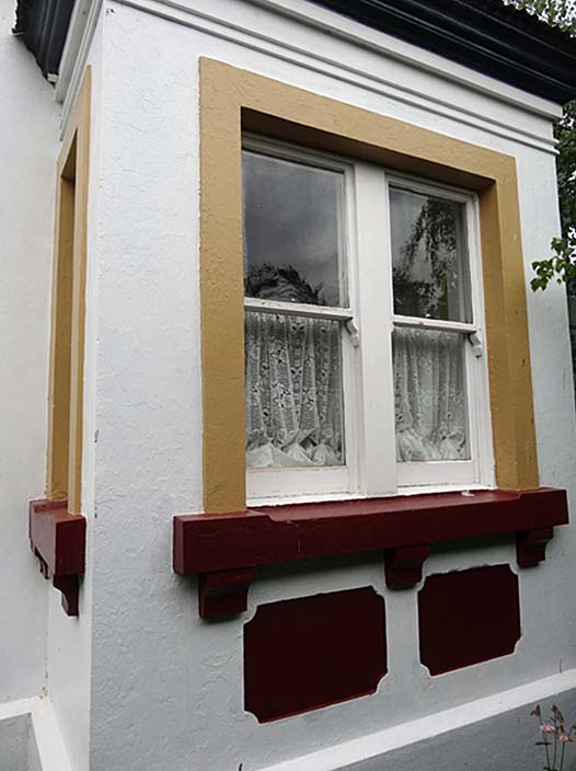
Current Description The small township of Burkes Pass sits at the base of the geographical pass of the Two Thumb and Rollesby ranges in the Mackenzie District. The Mount Cook Road Board Building (Former) is situated centrally within the township, on the western side of the Fairlie-Tekapo Road. About a dozen historic buildings are dotted along the main road in Burkes Pass. These are mostly relatively small, of timber or cob construction and include, at the south end of the town, St Patrick’s Union Church (Historic Place Category 1, List Entry No. 1967). The Mount Cook Road Board Building (Former) sits in its original section with road frontage onto State Highway 8, with a replacement front gate and part of the fence at the eastern boundary of the land parcel. At the western rear is a domestic garden, and beyond the land parcel is a paddock with several oak trees estimated to be over 110 years old. The building is single storeyed and has a slightly unusual form, comprising a four-roomed cottage at the south side and an adjacent three roomed administration wing to the north. Both wings are constructed of unreinforced concrete and timber with a corrugated iron roof and brick chimneys. Each corner of the building has decorative concrete quoins and a uniform concrete plinth encompasses the whole of both wings. The main rectangular wing forms the southern two-thirds of the floor plan and has a hipped roof, aligned north-south, and a slightly sloping verandah roof on its east elevation. The verandah posts support decorative iron fretwork. At the centre of this wing is a timber double-door, and a pair of sash windows is located on either side of the door. Situated immediately to the north side of, and running perpendicular to, the large rectangular wing is a narrower rectangular wing, with a hipped roof aligned east-west. It has an exterior entrance at the north end of the verandah. A large bay window is situated at its east elevation. Both concrete wings have numerous matching features, such as the decorative quoins, concrete plinth, window surrounds and sill brackets, as well as interior skirting and architrave mouldings. It appears, therefore, that the two concrete wings were built at the same time rather than in two stages. Windows are largely double-hung sashes. The front double doors lead to the main wide corridor which has four rooms leading off it. The smaller panel glazed side door leads to the other, narrower, corridor which has three rooms leading off it. The ceiling in the north-east room is of timber, formed in a diamond pattern and enclosed by mouldings. On the glass of one window in this room the name COWAN is etched. The walls have been wallpapered and painted. Every room has a fireplace. These range from open fireplaces, Victorian cast iron, coal range in the kitchen (circa 1940s), to double wood burners (1980s). There are no foundations, other than the external and internal walls which support the joists. In turn, the joists are supported by herringbone strutting. The external concrete walls are 30 centimetres thick and plastered internal walls are 16 centimetres thick. At the rear, on the west side of the building, are two gable roofed weatherboard wings, aligned east-west. These two distinct timber wings contain bathrooms, the south-western wing toilet possibly having been a separate structure originally. The wings cover some of the originally exterior west wall of the concrete wings and are additions. Changes have been made to the interior over time, including the periodic upgrading of heating systems, installation of new fireplace surrounds, and cabinetry. Recent changes on the outside include the insertion of salvaged cast iron fretwork on the verandah and the erection of a flag pole, new picket fence, gate and pergola. COMPARATIVE ANALYSIS Road Board Buildings Road boards were among the first examples of local bodies established in New Zealand and pre-dated most town administrations. In 1876, there were 215 road or highway districts in the North Island and 111 in the South Island, being 326 in total. In 1882, the Road Boards Act divided the country into 319 road districts, each governed by a road board. This reduced to 209 in 1907 and 59 in 1922, as the county councils took over road boards. Not all road boards would have had their own purpose-built offices. Of those that were built, it appears that few from the early period of road boards’ establishment in the nineteenth century survive. There appear to be no known purpose-built road board buildings currently on the New Zealand Heritage List/Rārangi Kōrero (‘the List’), although there is a proposal for the Castlepoint Road Board Office (Former), Tinui (List No. 4012) and a nomination has been received for the Mount Hutt Road Board Office (Former), Methven (List No. 9616). It is possible that some buildings entered on the List were formerly road board offices. Several borough or county council offices or former offices are currently entered on the List and may have included road board functions but none are similar in design to the Mount Cook Road Board Building (Former). Whereas the Mount Cook Road Board Building (Former) is constructed of unreinforced concrete and contains seven sizeable rooms, other known surviving purpose-built road board buildings are comparatively small and of timber. The standalone Mount Hutt Road Board (Former) was constructed in 1879 in timber comprising an office and cottage and survives at 59 Main Street, Methven, though shifted slightly from its original location within the same land parcel. A small timber former Lake Coleridge Road Board office from the 1880s survives, in poor condition on the main road to Lake Coleridge in Canterbury. In the Masterton District, the timber Castlepoint Road Board Office (Former) was constructed in 1884 and survives in its original location at 18 Manawa Road, Tinui. Accordingly, the Mount Cook Road Board Building (Former) is notable as a survivor of a type of building that was once reasonably common throughout the country. Its layout is likely to have been adopted because of the remote location. Early Concrete Buildings While timber was a ubiquitous construction material in nineteenth century New Zealand, concrete was used and forms part of our cultural heritage. The first use of concrete in New Zealand was predominantly in the form of plain or mass concrete, although a few isolated experimental attempts at reinforcing were undertaken from the 1870s. The first concrete structures in New Zealand date to the 1850s and 1860s, mostly as walls, foundations, floors, yards and rural structures. The earliest evidence of concrete still visible in New Zealand may be the remains of a circa 1857 retaining wall at Fyffe House, Kaikōura (Historic Place Category 1, List Entry No. 236). The oldest extant concrete building in New Zealand is believed to be a two storey house thought to have been erected in 1862 at Invermay, Mosgiel for John Gow (Historic Place Category 1, List Entry No. 2350). Musterers’ quarters, on Lake Coleridge station, mid-Canterbury are said to have been built a year earlier. Concrete stables constructed by Alexander Campbell near Outram also date from the 1860s. There was a great deal of interest in concrete as a new building material in the 1870s in New Zealand and, through considerable experimentation, its use increased during this decade. Advertised advantages of the use of cement concrete for house-building included ‘(1) increased strength; (2) greater durability; (3) reduced cost [and] (4) great expedition.’ Still considered to be a form of construction in its infancy in New Zealand, most known surviving concrete buildings in the country date to the mid 1870s or later. Early examples include the concrete powder Magazine near Lyttelton Harbour, built in 1874 (Historic Place Category 1, List Entry 7234). ‘Goldie’s Brae’, Wadestown in Wellington, is a large concrete house completed in 1876 (Historic Place Category 1, List Entry 216). ‘Woodside’ in Dunedin is a large concrete house built in 1876 to the design of F W Petre (Historic Place Category 1, List Entry 2184). Petre was sometimes known as ‘Lord Concrete’, and one of his most noted concrete buildings is St Dominic’s Priory in Dunedin, opened in 1877 (Historic Place Category 1, List Entry 372). Also in 1877, the St John’s Anglican Church (Historic Place Category 2, List Entry 1765) was built as part of a complex of village centre buildings at J C Wason’s Barrhill estate in the Ashburton District. At Glenmark Station in North Canterbury are the remains of a large concrete house built in the 1870s (Glenmark Station House Ruins, Historic Place Category 2, List Entry 1775) and 1881 stables (Historic Place Category 1, List Entry 277). Sunnyside Hospital, Christchurch, had a large concrete building constructed in 1871, but this no longer survives. In summary, there are a number of places built of concrete in the 1870s, and the Mount Cook Road Board Building (Former) is notable for falling into this category of early concrete buildings in New Zealand. Future investigation into its actual construction could add to the increasing interest in the body of knowledge about early concrete buildings in New Zealand.
Current Description The small township of Burkes Pass sits at the base of the geographical pass of the Two Thumb and Rollesby ranges in the Mackenzie District. The Mount Cook Road Board Building (Former) is situated centrally within the township, on the western side of the Fairlie-Tekapo Road. About a dozen historic buildings are dotted along the main road in Burkes Pass. These are mostly relatively small, of timber or cob construction and include, at the south end of the town, St Patrick’s Union Church (Historic Place Category 1, List Entry No. 1967). The Mount Cook Road Board Building (Former) sits in its original section with road frontage onto State Highway 8, with a replacement front gate and part of the fence at the eastern boundary of the land parcel. At the western rear is a domestic garden, and beyond the land parcel is a paddock with several oak trees estimated to be over 110 years old. The building is single storeyed and has a slightly unusual form, comprising a four-roomed cottage at the south side and an adjacent three roomed administration wing to the north. Both wings are constructed of unreinforced concrete and timber with a corrugated iron roof and brick chimneys. Each corner of the building has decorative concrete quoins and a uniform concrete plinth encompasses the whole of both wings. The main rectangular wing forms the southern two-thirds of the floor plan and has a hipped roof, aligned north-south, and a slightly sloping verandah roof on its east elevation. The verandah posts support decorative iron fretwork. At the centre of this wing is a timber double-door, and a pair of sash windows is located on either side of the door. Situated immediately to the north side of, and running perpendicular to, the large rectangular wing is a narrower rectangular wing, with a hipped roof aligned east-west. It has an exterior entrance at the north end of the verandah. A large bay window is situated at its east elevation. Both concrete wings have numerous matching features, such as the decorative quoins, concrete plinth, window surrounds and sill brackets, as well as interior skirting and architrave mouldings. It appears, therefore, that the two concrete wings were built at the same time rather than in two stages. Windows are largely double-hung sashes. The front double doors lead to the main wide corridor which has four rooms leading off it. The smaller panel glazed side door leads to the other, narrower, corridor which has three rooms leading off it. The ceiling in the north-east room is of timber, formed in a diamond pattern and enclosed by mouldings. On the glass of one window in this room the name COWAN is etched. The walls have been wallpapered and painted. Every room has a fireplace. These range from open fireplaces, Victorian cast iron, coal range in the kitchen (circa 1940s), to double wood burners (1980s). There are no foundations, other than the external and internal walls which support the joists. In turn, the joists are supported by herringbone strutting. The external concrete walls are 30 centimetres thick and plastered internal walls are 16 centimetres thick. At the rear, on the west side of the building, are two gable roofed weatherboard wings, aligned east-west. These two distinct timber wings contain bathrooms, the south-western wing toilet possibly having been a separate structure originally. The wings cover some of the originally exterior west wall of the concrete wings and are additions. Changes have been made to the interior over time, including the periodic upgrading of heating systems, installation of new fireplace surrounds, and cabinetry. Recent changes on the outside include the insertion of salvaged cast iron fretwork on the verandah and the erection of a flag pole, new picket fence, gate and pergola. COMPARATIVE ANALYSIS Road Board Buildings Road boards were among the first examples of local bodies established in New Zealand and pre-dated most town administrations. In 1876, there were 215 road or highway districts in the North Island and 111 in the South Island, being 326 in total. In 1882, the Road Boards Act divided the country into 319 road districts, each governed by a road board. This reduced to 209 in 1907 and 59 in 1922, as the county councils took over road boards. Not all road boards would have had their own purpose-built offices. Of those that were built, it appears that few from the early period of road boards’ establishment in the nineteenth century survive. There appear to be no known purpose-built road board buildings currently on the New Zealand Heritage List/Rārangi Kōrero (‘the List’), although there is a proposal for the Castlepoint Road Board Office (Former), Tinui (List No. 4012) and a nomination has been received for the Mount Hutt Road Board Office (Former), Methven (List No. 9616). It is possible that some buildings entered on the List were formerly road board offices. Several borough or county council offices or former offices are currently entered on the List and may have included road board functions but none are similar in design to the Mount Cook Road Board Building (Former). Whereas the Mount Cook Road Board Building (Former) is constructed of unreinforced concrete and contains seven sizeable rooms, other known surviving purpose-built road board buildings are comparatively small and of timber. The standalone Mount Hutt Road Board (Former) was constructed in 1879 in timber comprising an office and cottage and survives at 59 Main Street, Methven, though shifted slightly from its original location within the same land parcel. A small timber former Lake Coleridge Road Board office from the 1880s survives, in poor condition on the main road to Lake Coleridge in Canterbury. In the Masterton District, the timber Castlepoint Road Board Office (Former) was constructed in 1884 and survives in its original location at 18 Manawa Road, Tinui. Accordingly, the Mount Cook Road Board Building (Former) is notable as a survivor of a type of building that was once reasonably common throughout the country. Its layout is likely to have been adopted because of the remote location. Early Concrete Buildings While timber was a ubiquitous construction material in nineteenth century New Zealand, concrete was used and forms part of our cultural heritage. The first use of concrete in New Zealand was predominantly in the form of plain or mass concrete, although a few isolated experimental attempts at reinforcing were undertaken from the 1870s. The first concrete structures in New Zealand date to the 1850s and 1860s, mostly as walls, foundations, floors, yards and rural structures. The earliest evidence of concrete still visible in New Zealand may be the remains of a circa 1857 retaining wall at Fyffe House, Kaikōura (Historic Place Category 1, List Entry No. 236). The oldest extant concrete building in New Zealand is believed to be a two storey house thought to have been erected in 1862 at Invermay, Mosgiel for John Gow (Historic Place Category 1, List Entry No. 2350). Musterers’ quarters, on Lake Coleridge station, mid-Canterbury are said to have been built a year earlier. Concrete stables constructed by Alexander Campbell near Outram also date from the 1860s. There was a great deal of interest in concrete as a new building material in the 1870s in New Zealand and, through considerable experimentation, its use increased during this decade. Advertised advantages of the use of cement concrete for house-building included ‘(1) increased strength; (2) greater durability; (3) reduced cost [and] (4) great expedition.’ Still considered to be a form of construction in its infancy in New Zealand, most known surviving concrete buildings in the country date to the mid 1870s or later. Early examples include the concrete powder Magazine near Lyttelton Harbour, built in 1874 (Historic Place Category 1, List Entry 7234). ‘Goldie’s Brae’, Wadestown in Wellington, is a large concrete house completed in 1876 (Historic Place Category 1, List Entry 216). ‘Woodside’ in Dunedin is a large concrete house built in 1876 to the design of F W Petre (Historic Place Category 1, List Entry 2184). Petre was sometimes known as ‘Lord Concrete’, and one of his most noted concrete buildings is St Dominic’s Priory in Dunedin, opened in 1877 (Historic Place Category 1, List Entry 372). Also in 1877, the St John’s Anglican Church (Historic Place Category 2, List Entry 1765) was built as part of a complex of village centre buildings at J C Wason’s Barrhill estate in the Ashburton District. At Glenmark Station in North Canterbury are the remains of a large concrete house built in the 1870s (Glenmark Station House Ruins, Historic Place Category 2, List Entry 1775) and 1881 stables (Historic Place Category 1, List Entry 277). Sunnyside Hospital, Christchurch, had a large concrete building constructed in 1871, but this no longer survives. In summary, there are a number of places built of concrete in the 1870s, and the Mount Cook Road Board Building (Former) is notable for falling into this category of early concrete buildings in New Zealand. Future investigation into its actual construction could add to the increasing interest in the body of knowledge about early concrete buildings in New Zealand.
Historical and Associated Iwi / Hapū / Whānau
Completion Date
10th February 2015
Report Written By
Robyn Burgess
Information Sources
Gillespie, 1971
Oliver A. Gillespie, South Canterbury: A Record of Settlement, 2nd edn., Timaru, 1971
Lewis, nd
Lewis, Miles, 'Australian Building: A Cultural Investigation', http://www.abp.unimelb.edu.au/staff/milesbl/australian%20building/pdfs/6.00.pdf
Thornton, 1996
Geoffrey Thornton, Cast in Concrete: Concrete Construction in New Zealand 1850-1939, Auckland, 1996
Greenwood, 1983
Greenwood, William, Century of Challenge: Mackenzie County Council 1883-1983, 1983.
Jones, 2014
Jones, Martin, ‘Registration Report for Logan Bank, Auckland (Register No. 9643)’, 11 June 2014, Heritage New Zealand
Reed et al, 2008
Reed, Peter, Kate Schoonees and Jeremy Salmond, Historic concrete structures in New Zealand, Department of Conservation, 2008.
Walrond, nd
Walrond, Carl, ‘Roads – Funding road construction’, Te Ara – the Encyclopedia of New Zealand, URL: http://www.TeAra.govt.nz/en/roads/page-5
Other Information
A fully referenced New Zealand Heritage List report is available on request from the Southern Regional Office of Heritage New Zealand. Disclaimer Please note that entry on the New Zealand Heritage List/Rārangi Kōrero identifies only the heritage values of the property concerned, and should not be construed as advice on the state of the property, or as a comment of its soundness or safety, including in regard to earthquake risk, safety in the event of fire, or insanitary conditions.
Current Usages
Uses: Accommodation
Specific Usage: House
Former Usages
General Usage: Government
Specific Usage: Council/local government building
General Usage: Transport
Specific Usage: Road - transport - other
Current Usages
Uses: Accommodation
Specific Usage: House
Former Usages
General Usage: Government
Specific Usage: Council/local government building
General Usage: Transport
Specific Usage: Road - transport - other
Location
Sign up to hear more
Get the latest heritage news, features and events delivered
straight to your inbox.
