Mōkai Pātea
Mōkai Pātea in the central North Island extends from the Desert Road in the north to just south of Rātā near Marton, eastwards to the Ngaruroro River and the summit of the Ruahine ranges, and ends just west of State Highway 1 and Taihape. The four iwi of the Mōkai Pātea rohe are Ngāi Te Ohuake, Ngāti Hauiti, Ngāti Whitikaupeka and Ngāti Tamakōpiri, and all descend from the common founding ancestor, celebrated explorer Tamatea Pōtai Whenua of the Takitimu waka. Tamakōpiri was the son of Tamatea Pōkai Whenua and his wife Taanewhare; Te Ohuake descended from Kahungunu, son of Tamatea Pōkai Whenua and his wife Iwipūpū; and Hauiti and Whitikaupeka were cousins and the great-grandsons of Punua who descended from Ruaehu, son of Tamatea Pōkai Whenua and his wife Kahukare.
Tamatea Pōkai Whenua had journeyed into Mōkai Pātea, exploring much of the area accompanied by his son Kahungunu, where he named a number of places and left several mōkai (pets) as an indication of his mana and claiming of the land. The bestowing of names and leaving of mōkai provided a take (claim) under which his descendants could return and the people of Mōkai Pātea arrived over a period of seven generations, driving out the original Ngāti Hotu people, about whom little is known.
Hauiti was the son of Whakaruruhau of Te Hika ā Kahukare. Other significant Ngāti Hauiti tupuna include Topia Turoa, who was born near the Mangawharariki Stream which joins the Rangitīkei River a short distance upstream from the current location of Mangaweka Cantilever Bridge, and Matangi who came to the Manawatu from the Wairarapa, exploring the area in pursuit of flocks of kōkō and named places including Otamakapua, which lies east of the Rangitīkei River.
Ngāti Hauiti held the western and southern parts of the Mōkai Pātea rohe from the time of Hauiti to the mid-nineteenth century. One of the Ngāti Hauiti settlements on the eastern bank of the Rangitīkei River was known as Pounga, situated about 350 metres north of where the Mangaweka Cantilever Bridge is now located. From Pounga an overland track, which formed part of the Otara-Taupō-Pātea overland route, passed in a north and north-easterly direction towards another settlement at Hawanga.
Rangitīkei River
The Rangitīkei River also has historical, cultural, spiritual, and traditional significance outside of the Mōkai Pātea rohe. It has long provided a means of communication and trade, for instance its route through the central North Island was used a number of times by taua (raids) and heke (migrations) during the Musket Wars of the 1820s and 1830s. The river forms part of the boundary of the Rangitāne o Manawatū rohe and is at the heart of the traditional lands of Ngāti Apa.
The Arrival of Pākehā
The people of Mōkai Pātea had certainly felt the impact of Pākehā by the mid-1860s, but there were essentially no Pākehā residing in their rohe at that time, and tangata whenua there ‘remained largely unknown to the outside world’. That soon changed following the arrangement of leases with private runholders in the 1860s in the northern part of the rohe. In 1868 brothers Captain Azim and William John Birch were the first Pākehā to settle in Mōkai Pātea after negotiating with Ngāti Whitikaupeka to lease a sheep run on the Orumatua-Kaimanawa block, northeast of Moawhango.
Other early runholders followed but transportation of wool was an issue with no road or rail access. In 1883 the ‘Gentle Annie’ road from Napier finally connected to Moawhango, which went on to become the ‘business centre’ of inland Pātea, and access was also improving in the southern part of Mōkai Pātea. A bridle track was cut along the survey line of the Main Trunk Railway in the mid-1880s and by 1888 the railhead had reached Kaikarangi, just north of Hunterville.
The Awarua and Otamakapua Blocks: Crown Acquisition
Crown purchase of Māori land in the Rangitīkei was driven by the construction of the North Island Main Trunk Railway Line, the completion of which relied upon the acquisition of land from Māori. By the end of the nineteenth century, land on either side of the Rangitīkei River had been brought before the Native Land Court. The two blocks of land that are of particular significance to this report are the Awarua Block and the Otamakapua Block. The Rangitīkei River formed a boundary between these two blocks.
On the western side of the river, the Awarua Block (circa 256,000 acres) was at the heart of Mōkai Pātea and encompassed the land between Mangaweka and Moawhango. This land is of deep significance to the people of Mōkai Pātea, being where their settlement was concentrated, and the Awarua Block has been described as ‘rohe pōtae’. It was also of immense importance to the Crown as the proposed route of the Main Trunk Railway passed directly through the western part of the block. The block had ‘a turbulent and protracted history in the Native Land Court’ – the title was first investigated in 1886 and the block was vested in 437 Māori owners, descendants of Ohuake, Hinemanu, Hauiti, Whitikaupeka and Tamakōpiri. Partition hearings were undertaken during 1890-1891 and the Awarua block was partitioned into nine smaller blocks, with the township of Mangaweka later established on part of block Awarua 4B.
On the eastern side of the river, the Otamakapua Block (circa 147,000 acres when first surveyed) was one of the first major land blocks to be purchased in the Taihape District by the Crown and was the subject of Native Land Court hearings from 1870-1894. Most of the Otamakapua Block had been sold into Crown ownership by 1884.
Mangaweka – From Three Log Whare to a Prosperous Township
By 1891, a road extending north from the railhead at Hunterville, turned into a bridle track just south of Taihape, known as Ross’s track. The government erected shelters along this road and the third of these was originally called Three Log Whare. Three Log Road connected the town to the river crossing and it was renamed Mangawharariki Road in 1904. The settlement became known as Mangaweka in 1894, by which time it boasted a store, post office, school, hall, and a number of businesses. By the turn of the century, the population had reached almost 1000 people.
The early prosperity of Mangaweka was fuelled by the settlement being the point of supply for both railway workers and the increasing number of settlers establishing farms in an area that had previously been covered by native bush. Following the completion of the Makohine viaduct, the railway line was open to Mangaweka by November 1902 and reached Taihape by 1904.
Development of crossings over the Rangitīkei River near Mangaweka
The development of transportation was crucial for Pākeha settlement around the Rangitīkei River, as it was in many areas of New Zealand. The construction of bridges was fuelled by the development of roads and railway lines, and by the risk unsafe river crossings posed to lives and livelihoods. Around 1894, a farming settlement was established at Kawhatau Valley, on the eastern side of the Rangitīkei River. The first settlers reached the valley via Kimbolton, cleared land for their houses and, once Kawhatau Valley Road was built, established several timber mills. The river could be forded at several locations including upstream in the vicinity of the NIMT railway bridge and downstream at the base of the cliff, nearer Mangaweka township. A ferry crossing was provided by Thomas Scott and a wire cage (1896) suspended on a wire cable also provided transport over the river, at a location that is downstream from the present site of Mangaweka Cantilever Bridge.
Soon after settlements were established, residents began lobbying the government for a bridge crossing and in 1895 funds were allocated for this purpose. The contract for two bridges was given to the road surveyor, G T Murray. The first bridge to be constructed was a temporary low-level pine bridge, completed 1897, which sat just above the normal water level of the river to allow for flood waters to pass over the top. It was frequently affected by rapidly rising floodwaters, however, which would render the crossing unsafe or unusable; at one time residents could not safely cross the bridge for a week. By this time, the Kawhatau Valley was an established settlement and boasted two schools, but the river crossings did not allow for safe and regular transport of residents or produce.
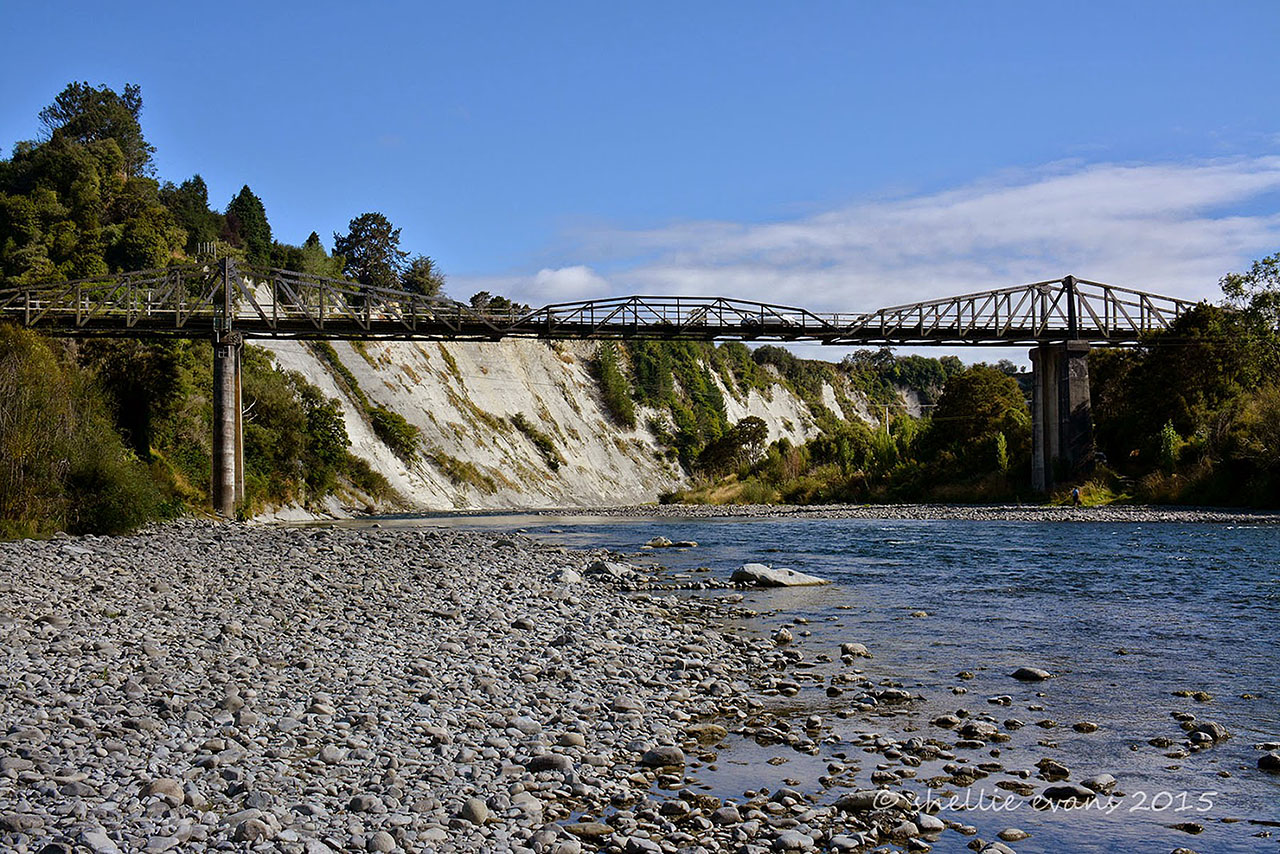
Work on a permanent bridge was undertaken concurrently with the low-level one and it was partially completed when severe flooding in mid-April 1897 caused the river to rise 32 feet (9.75 metres) above its usual level, reaching the tops of the new concrete piers. This event led to the abandonment of the bridge design, which comprised two spans and a cylindrical midstream pier, in favour of a cantilever design.
Construction of the new bridge, however, was delayed and although the low-level bridge was repaired after the 1897 flood, it was washed out again in July 1898 and 1902. When the low-level bridge was washed away in 1902, the mills at Kawhatau were closed and employees paid off. This situation resulted in years of frustration for residents. In 1898 they urged the government to attend ‘to the urgent necessity that exists for erecting a permanent bridge’, on the grounds that: a bridge had been promised three or four years earlier and concrete piers were nearly completed, the dangerous crossing of the river had placed settlers in the Kawhatau valley at a financial disadvantage and led to the loss of life, and that the low-level bridge was occasionally ‘submerged and of no use.’ In mid-1900 a deputation asked for the construction of the bridge to ‘be pushed on as expeditiously as possible’, pointing to the dangers of the low-level bridge and the loss of many horses. Tenders were called for by the Lands and Survey Department in April 1900 but when the Minister of Public Works, the Hon W Hall-Jones, visited the site of the low-level bridge two years later, on the day of the official opening of the Makohine viaduct, he was confronted with a delegation enquiring about the government’s failure to fulfil its pledge to build a permanent bridge, despite eight years of promises.
Construction of the Mangaweka Cantilever Bridge
On 27 October 1902, the Public Works Department again called for tenders for the construction of the bridge to the specifications of plans drafted in 1899. The site for the new bridge was to be that of the low-level bridge and the never-completed cylinder bridge. The design had been prepared by the Public Works Department, the government agency charged with the design and construction of New Zealand’s infrastructure from its inception in 1876 to its demise in the late 1980s. Many of the department’s engineers and architects were regarded as leaders in their fields. A cantilever design with a central span that sat higher above the river was favoured because of the magnitude of the 1897 flood, because it would allow ‘sufficient clearance for similar floods’.
On 15 December 1902, J & A Anderson Ltd of Christchurch accepted the contract for the bridge’s construction. The firm capitalised on Julius Vogel’s scheme for expanding the railway and infrastructure and developed a strong reputation for building road and rail bridges, and for constructing complicated and difficult engineering structures in challenging locations. Their engineering projects included railway and road bridges, gold dredges, coastal steamers, hydroelectric works and the Farewell Spit lighthouse. The founder of the firm, John Anderson (1820-1897), was not only a highly respected engineer but also served the community as Christchurch’s second mayor. He was also a director of a number of companies. Two of his sons, John and Andrew, joined the firm in the 1870s and they led it to a ‘pre-eminent position among New Zealand construction companies’ after his retirement in 1881.
A camp was established to accommodate workers during the different phases of construction of a bridge near Mangaweka between 1897 and 1904. Such camps were necessary for the construction of infrastructure in remote areas. J & A Anderson Ltd’s camp was located on reserve land currently occupied by a campground on the western side of the Rangitīkei River, downstream of the bridge site.
The two concrete piers that had already been constructed on either side of the river were extended in height to fit the new design. Outer piers of a simpler design were constructed further up the banks. Concrete abutments, set about 10 metres outside the inner piers, had been produced by Luke & Co’s foundry at Te Aro, Wellington, for the earlier cylinder bridge. New abutments were constructed at the crest of the terrace, and cutwaters were added to the upstream side of the inner piers.
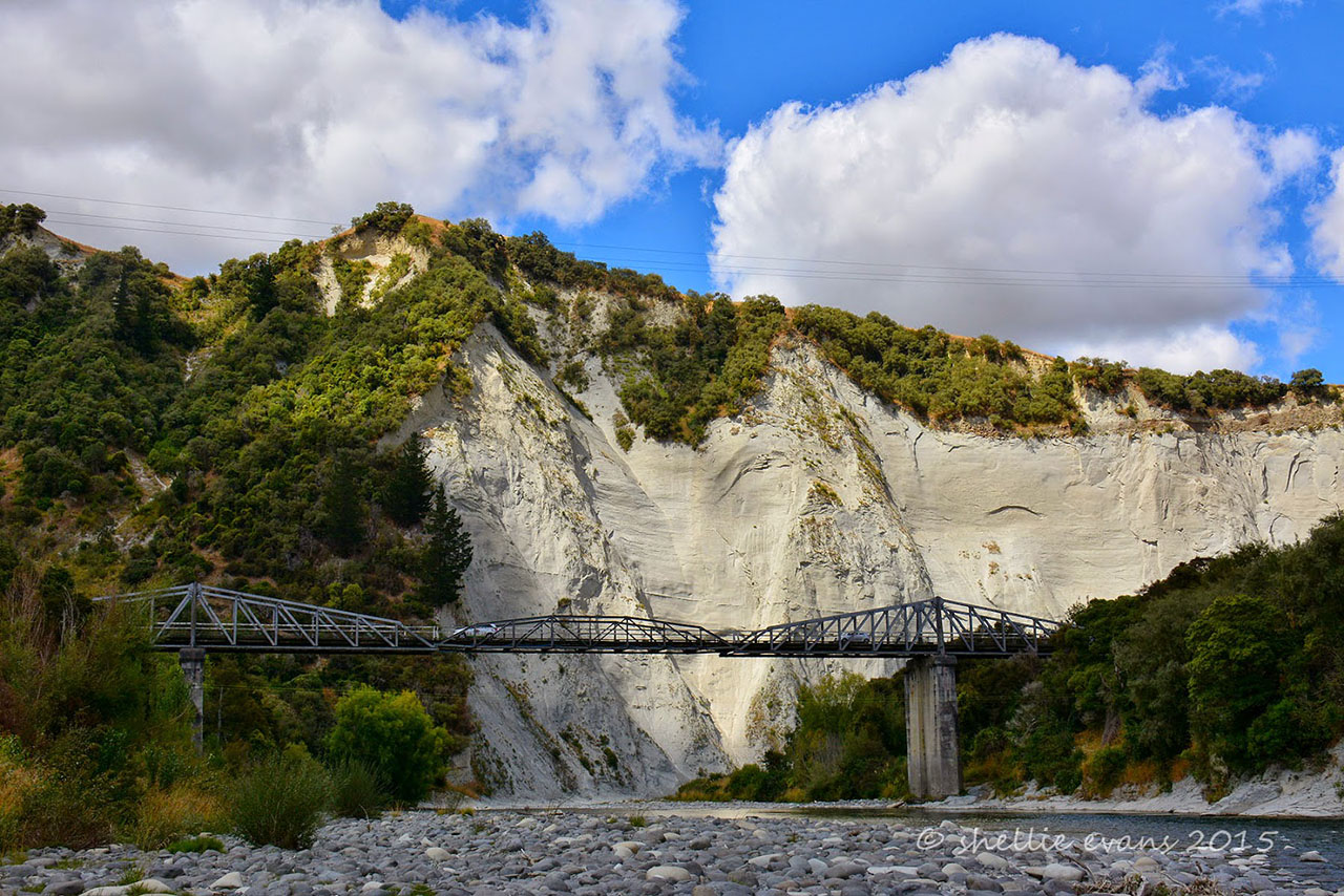
Concrete has been used in New Zealand for bridge piers since the 1850s, but the cantilever design was not commonly used in this country. In fact the Mangaweka Cantilever Bridge was to be the only steel cantilever road bridge ever built here and one of only three known extant cantilever bridges or viaducts in the country, the others being: Waiau Ferry Bridge (1887) in North Canterbury, ‘probably one of the most handsome bridges of its kind in New Zealand’, opened with a large gathering, and the Makohine Viaduct (1902), just south of Mangaweka, which has been described as a ‘dramatic example of the cantilever’. The fact that the Mangaweka Cantilever Bridge was the last of these to be built and has not received any especial praise suggests it did not particularly influence construction and design techniques in New Zealand. Mangaweka Cantilever Bridge was built with a central span of 242 feet and the trusses were manufactured by J & A Anderson. Mr Reaney was the District Engineer and the bridge was erected under the supervision of Mr H J Hayns of Palmerston North.
A Community and Tourist Icon
The long-awaited bridge was completed in August 1904. There is no record of the bridge being formally opened, although an event had been planned for 12 September 1904 with the Hon Mr Hall-Jones, Minister of Public Works, in attendance, when a parliamentary delegation was to be in the area for the completion of the Main Trunk line. Neither event took place though and when the Main Trunk line was finally opened in November that year, an event for the Mangaweka Cantilever Bridge was not included in the celebrations and there is no record of an opening taking place until a much belated official opening was held on 7 March 2015, complete with a procession of vintage motor vehicles and horses, attendees in period costume and a brass band.
That such an event was held 111 years after the bridge was completed, shows the significance and value of this bridge within its community. Without the bridge, the Pākehā settlement and economic development of this part of the country would have been seriously impeded. The challenges surrounding the settlement and development of the area, and in obtaining adequate means of transportation and communication, had no doubt helped solidify the bridge as a key local amenity and a source of pride.
The near absence of newspaper articles about the bridge after its completion contrasts with its newsworthiness during the decades preceding its construction. Perhaps this is the result of the structure being quietly successful in meeting its community’s needs. The high use of the bridge is evidenced by the need for the deck timber to be replaced just nine years after the bridge was completed, due to the totara having ‘been almost cut in two by the heavy traffic.’ Just a decade later, in early 1923, the Rangitikei County Council found further repairs to the decking were required. In the mid-1930s the bridge was repainted. When the bridge was assessed in July 1947, it was found to be in good condition, with just the troughs and lower chord needing to be cleaned out and painted, and some running planks replaced. More significant work was undertaken in the 1950s, including the installation of a water level recorder tower alongside the bridge in 1953.
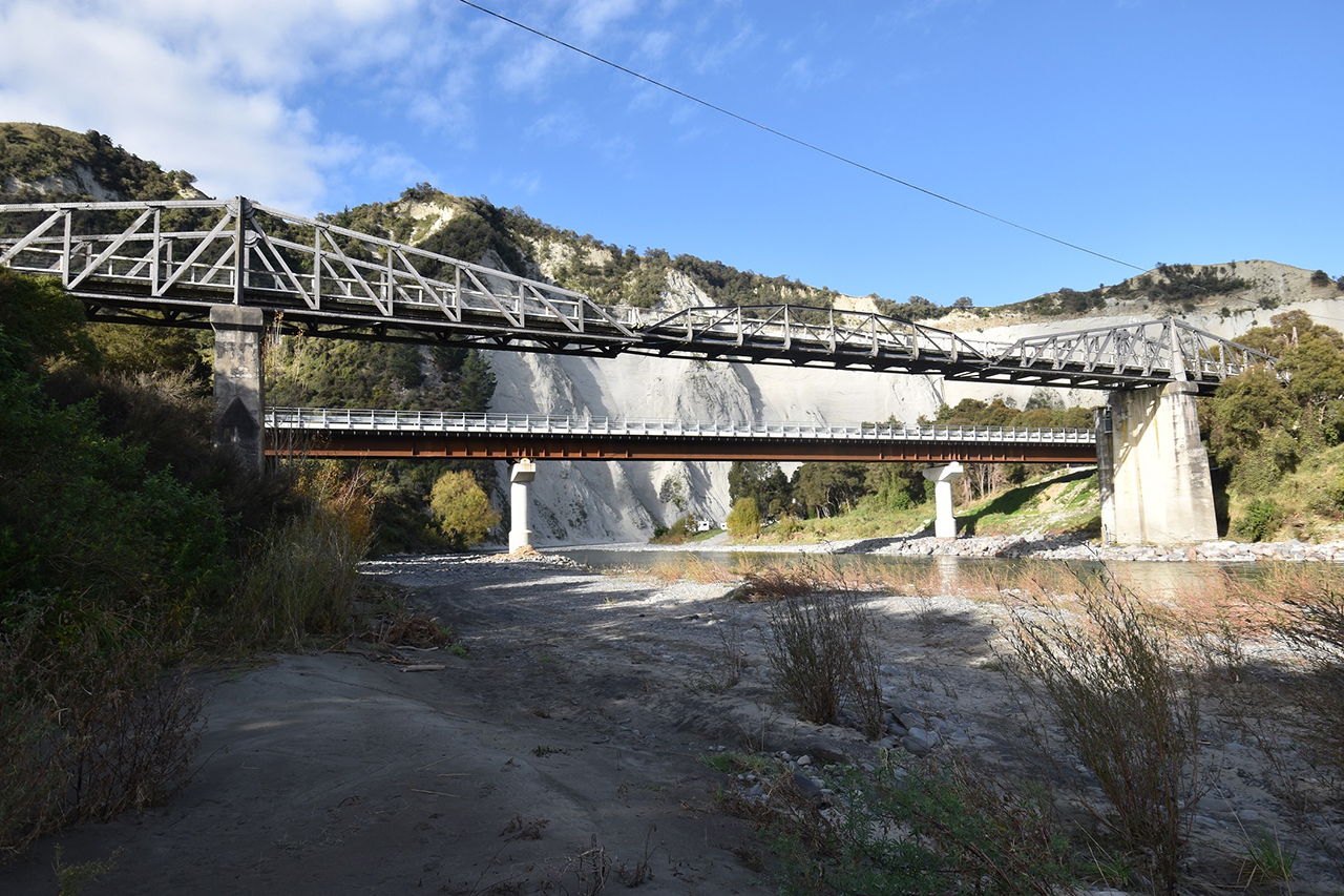
By the late twentieth century, the townships and industries the bridge serviced had altered considerably. When Mangaweka reached its centenary, for instance, it was ‘no longer the bustling hub of the farming community’ and had ‘a slowly dwindling business community’. Mangaweka Cantilever Bridge remained in use as a road bridge until 2016, when it was closed due to decreased weight capacity. Further investigation found that one of the bridge’s piers was scour-prone and various courses of action were considered, including demolition. Following ‘overwhelming support’ from Rangitīkei and Manawatū ratepayers during public consultation in 2019, the two regional councils responsible for the bridge opted to repair it to serve as a pedestrian and cycle bridge. The form and design of Mangaweka Cantilever Bridge is largely unchanged from the time it was completed.
The councils retained ownership of Mangaweka Cantilever Bridge, while responsibility for its preservation, maintenance and management was vested in the Manawatu Heritage Incorporation. The bridge currently forms a celebrated part of Manawatu’s Iron Gates Experience; the Manawatu ‘Country Road’ Scenic Route; and the Rangitikei Cycleway. It also serves as a viewing platform in an area frequented by people camping, rafting, kayaking, and fishing.
A replacement road bridge was constructed 2021-2022. Its official opening on 20 May 2022 provided an opportunity for the community to come together to celebrate the new bridge and demonstrate community attachment to Mangaweka Cantilever Bridge. Artist Maihi Potaka was commissioned to design a pou to stand beside the new bridge, and he described his design as symbolising ‘an age-old relationship between the people of the two districts’. His pou acknowledges the legacies of two tūpuna of Ngāti Hauiti: Matangi and Tamatea Pōkai Whenua.