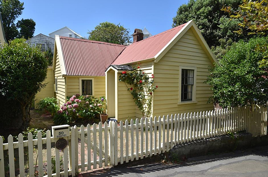
The cottage at 30 Ascot Street, Thorndon, was built in ca. 1863. Prior to Pākehā settlement the Thorndon area had been occupied by Te Ātiawa, Ngāti Tama and Ngāti Mutunga iwi, all of whom had migrated south from Taranaki in the 1820s and early 1830s during a period of great upheaval associated with the introduction of Pākehā muskets into te ao Māori. Initially based on the Kāpiti Coast, the Taranaki groups moved further south to present-day Wellington. Kāinga (villages) were located in the Thorndon area, including Pakuao at the north end of Tinakori Road, Raurimu at the intersection of Hobson Street and Fitzherbert Terrace, Tiakiwai nearby, and Pipitea Pā on the shoreline. The Taranaki tribes were the last arrivals in region with a long history of Māori occupation stretching back to the explorer ancestor Kupe, who named islands and landmarks around the harbour. Prior to the entrance of the Taranaki tribes, occupancy of Te Whanganui a Tara was concentrated in the eastern and southern coasts, as the western portion of the harbour was seen as vulnerable to attack from the north.
Pākehā Settlement
Thorndon was part of the highly controversial and much disputed purchase of Te Whanganui-a-Tara (the great harbour of Tara) by the New Zealand Company in 1839 for the site of what became known as Wellington. After the New Zealand Company shifted the fledgling settlement to Lambton Harbour from Petone in April 1840, the northern end became known as Thorndon, after the English home of New Zealand Company director Lord Petre.
The Company divided the new settlement into 1100 town and country sections, which were sold to investors and potential settlers before they had even left England. Company surveyor William Mein Smith prepared the plan for the settlement of Wellington. He chose a rigid grid plan when the settlement was proposed for flat land at Petone, but the unruly terrain at the southern end of the harbour meant a series of inter-connected grids was required in Wellington.
Development of Thorndon
An important route in Thorndon was Tinakori Road, which ran from the harbour south along the base of Te Ahumairangi/Tinakori Hill, more or less following the earthquake fault line that is such a defining physical feature of the place. It began as little more than a track that linked Thorndon to areas of settlement and farming further afield, such as Karori. As Thorndon became more intensively settled, Tinakori Road evolved into an established street, occupied at the northern end by the well-off and at the southern end by the middle-class or, mostly, working class; colonial Thorndon was socially diverse, with rich and poor living in close proximity. The smallest cottages were to be found off the main road, adjoining narrow streets and lanes and occupying tiny sections. These cottages provided cheap housing for workers and their families close to places of employment in the city. As the city’s population grew, more houses were packed into the suburb, particularly in its central and southern areas.
Ascot Street
Ascot Street links Sydney Street West and Tinakori Road at the heart of the latter’s short commercial section and was partly created out of a subdivision of Town Acres 516 and 518. It was a private right of way that gave access to the newly-built houses off Tinakori Road and was very narrow, so could never be used for anything more than people on foot or horses. It was nevertheless a useful thoroughfare until superseded in 1886 by the lower and wider Glenbervie Road, which connected Tinakori Road with Kumototo Street (along today’s Bowen Street). Initially the access way was simply known as the ‘lane’. The west part was soon known as Karori Place; the harbour side of the street had various names but it was mostly known as Sydney Street Cutting and Glenbervie Cutting. Finally, in 1927, after an enquiry by a resident, the Wellington City Council decided to call it Ascot Street.
The Cottage
Many of the street’s working class cottages were constructed between 1860 and 1875, with only one lot remaining unsold by 1876. The transfer of Government from Auckland to Wellington in 1865 seems to have been one of the spurs for the development of the area.
In 1860 part of Town Acre 516 was purchased by William Phelps Pickering, a former Australian convict. In 1864 Pickering, listed now as a ‘gentleman’, sold a section of Town Acre 516 to watchman William Cooper, who was his heir. Cooper had built the cottage by then, so this transaction was formalising something which had already taken place. The date of construction for the cottage is not certain but rate books suggest a date of no later than 1863, that being the year that rate book records began. It may well have been earlier. The relative ease with which working people like William Cooper could acquire land and build a house contributed to New Zealand’s reputation as a ‘workers’ paradise’ in the nineteenth century.
It is most likely that the house was built in one construction period, but the eaves of the two gabled wings at right angles to each other do not align, suggesting the possibility of two stages of construction. The whole roof was likely clad in shingles but by 1885 the main roof was clad in corrugated iron, with only the porch still shingled. It was typical of working class cottages that Charles Rooking Carter described in 1866 as:
‘…in a style of genuine simplicity … a door in the middle and a window on each side of the door. The house was divided into two rooms … and was frequently supplemented with the fashionable and useful lean-to … in the rear of these truly convenient and comfortable colonial cottages, which being generally painted white, look neat, clean and fresh.’
Though it does not conform exactly to this description, it nevertheless fits the character-defining aspects of the style.
Sarah Cooper’s School
William and Sarah Cooper, who married in Birmingham, England in 1852, arrived in Wellington in 1857 on board the Alma. One source suggests that Sarah came to New Zealand to act as a governess for Charles and Helen Gillespie. She was described as governess in her death notice. William died in 1866 aged 50, and his death may have spurred Sarah to open a school in the house.
The first definitive record of this school was in a street directory in 1878, although it was operating much earlier. Just what the school amounted to is not at all clear. In The Streets of My City (1948), Fanny Irvine-Smith cited a contemporary witness describing the school as consisting of a single room with a playground outside. Sarah herself was described as ‘a tiny little teacher, spectacled and rosy cheeked, in print bonnet and voluminous skirts.’ She taught her pupils lessons in the alphabet (accompanied by singing) and basic skills such as knitting. On Fridays, as a special treat, Sarah would reward the children with sweets such as toffee or coconut.
Marcus Marks (1863-1951) was an early student of Sarah’s. He recalled a woman of a quite different stature:
‘…a tall, thin, grey-haired lady with “specs”. Mrs Cooper was a martinet; but her severe method of dealing out punishment (rapping us hard over the knuckles with a lead pencil) was tempered by the motherly way she regaled us every Friday afternoon – coconuts cut up into small pieces with a bucket of fresh water from Grant Road to wash it down.’
She may have been running what would be more readily understood today as a pre-school or infant school for local children under her care, possibly including the Gillespie children. The spaces in the cottage are very small so there would have been room for only a small group of pupils. It is unusual that not one newspaper report or advertisement for the school has been found; private schools were frequently featured in the media or were advertising for students.
Street directories show her school in operation until 1901, but her 1898 obituary noted she had closed it ten years prior, so it is hard to be sure of the accuracy of this date. There is no clear evidence that Sarah Cooper was known in her lifetime as Granny Cooper, although this name has been attributed to the cottage for many decades.
Sarah Cooper died in 1898 aged 76 and she had spent the final two years of her life living with the Gillespies. She left her property to Helen and Helen’s oldest son Andrew, although only Helen’s name appeared on the title. The Gillespies never lived in the house and the first occupant following Sarah’s death was Jane Cooper, whose late husband Thomas Cooper had been a veteran of the 65th Regiment of the British Army. What the connection was between the two sets of Coopers is not known, but it seems likely to have been a familial one.
Later History
Following Helen Gillespie’s death, the cottage was transferred in 1910 to her son Robert Morton Gillespie, an engineer living in Auckland. Later that year he sold the property to driver Alfred Holt, who lived in the cottage. In 1914 it was bought by storekeeper Alfred Bowden, who also occupied it. Bowden’s sister Catherine Arlidge bought the cottage in 1923. She and her husband Albert lived there but Albert moved out when they divorced in 1925. The couple’s marriage breakdown was covered by tabloid newspaper The Truth in uncomfortable detail, as was Albert’s failed attempt to gain a share of the property through court action in 1927.
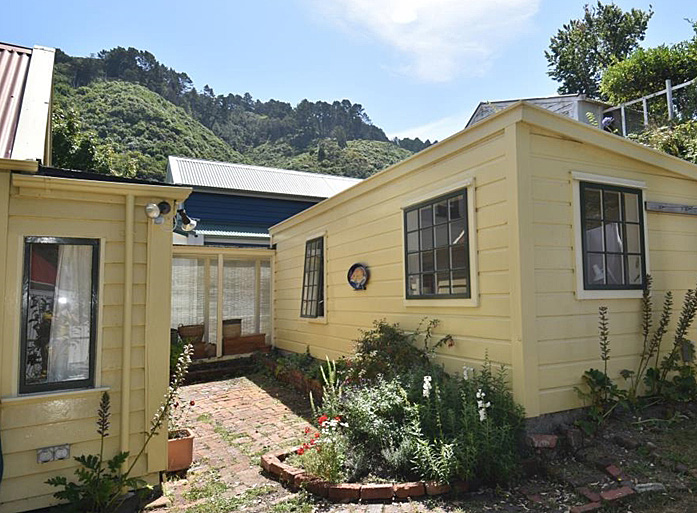
In 1930 Catherine Arlidge constructed a garage, which had a splayed side wall to make full use of the small front garden, leaving just a narrow path to the front door. The garage plans show that there was a separate structure behind the cottage which contained a workshop, a washhouse, toilet and a coal bin. This was not on the site before 1900. A narrow lean-to added to the rear (north side) of the cottage does not appear to have been there before 1900 either, although it does contain multi-pane sash windows which could easily have been moved from the back wall of the cottage when the lean-to was added.
The property remained in the Arlidge family until the 1970s but was not occupied continuously by them. A long tenancy was held by Reginald Mather, a clerk, during the 1940s. Slaughterman William Aldridge was also listed as the occupant during the 1930s. Rose Nelson was the listed occupant during the 1960s.
Thorndon Trust
In 1972, the cottage was put up for sale by the Arlidge family. By this time the Wellington urban motorway was under construction and a number of houses to the east and north of Ascot Street, including much of Sydney Street West, had been demolished. Other streets were also badly affected by the motorway. The cottage was not under threat by the motorway construction, but rather from a proposal to demolish the building to give access to surrounding land-locked houses, particularly above to the north, at number 275 Tinakori Road. These were to be demolished to make way for a large residential development.
Alarmed at this, and the prospect of the continuing loss of the area’s historic houses, a group was formed comprising architect Martin Hill, who had drawn attention to Thorndon's heritage in newspaper columns in the late 1960s, television researcher Gillian MacGregor, who was living in Glenbervie Terrace at that time, and lawyer Shirley Smith, whose husband was the prominent economist William Sutch. Together, they formed the Thorndon Trust, bought the cottage in 1972 against fierce bidding at auction and secured a mortgage through Shirley Smith’s legal practice.
The Trust began planning to raise money to restore and renovate the cottage with voluntary help from the community; this was achieved by the Trust sponsoring the formation of the Thorndon Society in September 1973. Membership of the Society was open to anyone, whether a local resident or not, who shared the aim of preserving the historic ambience of Thorndon.
One of the first activities of the Society was to demolish the garage, which took place during Saturday morning working-bees. These and similar working-bees, and many social events sponsored by the Society, engendered a strong community commitment to heritage, and laid the base for the town planning activism that was to save the area from wholesale redevelopment.
Zoning
Following the cottage purchase in 1972, an intense period of research and lobbying was undertaken by the Thorndon Trust, concentrating on the owners’ expectations for the future of the densely built-up area that later became known as the Residential E Zone. This is the area bounded by Bowen Street, Tinakori Road, Hill Street and the motorway, and included Sydney Street West, Ascot Street, Glenbervie Terrace and Parliament Street. Research showed that a large majority of residents liked living in the area and favoured preservation over redevelopment, this despite the fact that the area was generally in a run-down condition.
The Wellington City Council (WCC) was approached to rezone the area to protect its unique townscape qualities, encourage restoration, and control new development so that it was compatible with the old. While this was a novel idea to the WCC (and indeed, to New Zealand), conservation zones were common in Europe and were used in the United States and Australia. Citizen-led campaigns to preserve the historic character and communities of Greenwich Village in New York (late 1950s) and The Rocks in Sydney (early 1970s) were high-profile battles in an international movement that the Thorndon activists participated in.
The acquisition of the cottage was the catalyst for the establishment of what became known as Residential E Zone, which in turn pioneered a cultural landscape that subsequently informed heritage practice in New Zealand. In 1973 WCC adopted a plan change to protect the area, dubbed Residential E Zone. The change was rejected by the Planning Tribunal the following year but revisions were made and the area (slightly enlarged) was finally adopted in 1976. This was the first time in New Zealand that a defined area (urban or rural) was set aside for legal protection for its built heritage values. Many more examples followed nationally over the succeeding decades and Thorndon was cited as a precedent when Nelson’s historic South Street was made a special character zone in 1980.
In 2010, an attempt to extend protection to the western side of Tinakori Road was abandoned following complaints from some in the community. The former Residential E Zone remains intact today however, as part of a character area under the Wellington City District Plan. The historic qualities of Thorndon and protective zoning have contributed to its subsequent gentrification.
The Cottage Renovations
Following the acquisition of the cottage, the Thorndon Trust planned major work to make it more suitable for modern living. The cottage was in poor condition and the work required – plumbing, electrical and carpentry repairs, and the upgrading of service rooms – was extensive, both externally and internally. By 1975, renovations designed by architect Martin Hill got underway; the outbuilding building was converted into useful living space containing a toilet, bathroom and bedroom, new window joinery was installed, and a glazed passage was built to connect it to the main cottage. A small porch was built over the front door, the design based on an 1885 photo of the cottage. The glazed link and the replica front porch were the only changes made to the footprint of the building, which has not altered since.
Architect Philip Porritt, a member of the Thorndon Trust from 2004 to 2019, designed and oversaw many small-scale improvements to the cottage, including new kitchen fittings, improved bathroom facilities, the cladding of the street elevation of the glazed passage to improve privacy, and the construction of a retaining wall behind the outbuilding. The cottage has had a number of tenants since 1975, the very first being ballerina Pamela Meakins of the New Zealand Ballet Company in 1976.
While the purchase of the cottage by the Thorndon Trust was critical in ensuring the preservation of the area, and was its main concern during its early life, the Trust did buy other at-risk properties, including 28 Ascot Street (next door) and 194 Sydney Street West, later to be on-sold to sympathetic owners. Today, the Thorndon Trust is still active in the area and owns the cottage and Rita Angus Cottage at 194A Sydney Street West (List No. 2291, Category 1 historic place).