

Stephen Watson was born in Deptford, London, in 1811. Following his elder brothers, Watson went to sea at an early age, working aboard whaling and merchant trading vessels working out of Sydney, around New Zealand and in the Pacific. Watson is believed to have travelled from Sydney to Aparima or Jacob’s River, as the Riverton area was then known. He arrived at Johnny Jones’ newly established whaling station. Watson returned to Sydney in 1839 in Jones’ employ, before returning again to buy seal skins. Watson brought with him his bride, 24-year old Bridget (nee Mullins, born circa 1816). Bridget was reportedly the ‘first European woman to settle permanently in Southern Murihiku.’
Around 1858 Bridget Watson died at their farm and was buried on the property at an unknown location. Stephen Watson remarried Catherine Murchison (b. 1822), a newly arrived settler from Kintail in Scotland. Catherine had borne a daughter on the voyage – Catherine Meche Murchison, seven weeks old on her arrival in Dunedin. Stephen and Catherine married on 21 February 1860. Catherine’s brother Finlay built the couple a new house, assisted by his nephew Roderick McRae. The stone was carted from Isla Bank, a settlement closer to Invercargill. The stone house had four rooms, with a timber lean-to added later. The property was renamed Kintail after Catherine’s Scottish home. In November 1864, Catherine gave birth to son Stephen Watson junior, who along with his half-sister attended the local Birch Bush School. Members of the Watson-White family lived on the property until the 1980s, when it was sold outside the family. Catherine’s life story, her child conceived out of wedlock, and the hostile reaction of Free Church settlers who saw her as of poor character and a reflection of Catholic morals in general, provide insight into the experience of Catholic settlers in early Otago.
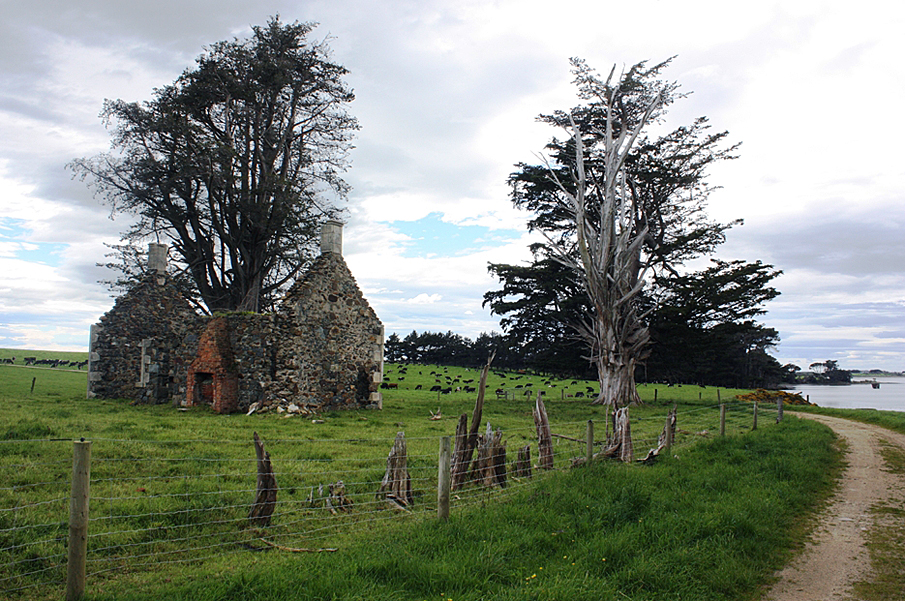
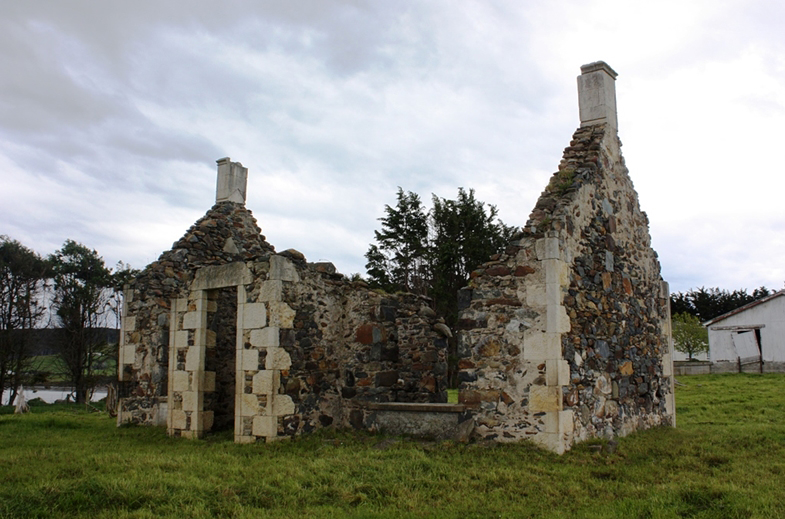
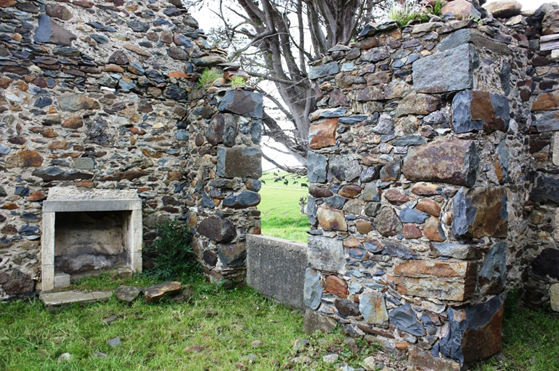
Kintail is a stone ruin – the exterior walls and front porch are standing, with the gable end walls being most intact. The walls are constructed with both shaped stone and random rubble brought to course. The kitchen may have been housed in a lean-to on the rear elevation, as a brick chimney breast remains that could be the right size for a coal range. The remains of the house indicate a one and a half storey dwelling of some status. The status is indicated in the detail – particularly the stone quoining. This is an early house for the area dating from the early pastoral period and the subdivision of the Jacobs River Hundreds. It is significant remnant of a settler house identified with an early settler figure in Southland’s history and with a long standing relationship to that family.
In 2017, the ruins of the homestead sit near the modern homestead and recall the long history of the Watson-White family of Aparima.
List Entry Information
Status
Listed
List Entry Status
Historic Place Category 2
Access
Private/No Public Access
List Number
9775
Date Entered
25th May 2017
Date of Effect
15th June 2017
City/District Council
Southland District
Region
Southland Region
Extent of List Entry
Extent includes part of the land described Sec 12 Blk III Jacobs River Hundred (RT SL7B/277), Southland Land District and the structure known as Kintail (Former) thereon. (Refer to map in Appendix 1 of the List entry report for further information).
Legal description
Sec 12 Blk III Jacobs River Hundred (RT SL7B/277), Southland Land District
Location Description
Located at the end of Narrows Road, 100 metres away from the present-day homestead. Kintail (Former) is located in a paddock at the eastern end of the farm buildings.
Why is this place significant?
Historic Significance
Historical Significance or Value The history of Kintail and its association with Stephen Watson, a contemporary of Captain Howell and Theosophilus Daniels, old identities in nineteenth century Southland give the place historical significance. Watson’s association with sealing and early farming in Southland tell a significant story in Southland history. The story of his wife Catherine provides insight into the lives of early Catholic settlers in a predominantly Scottish Presbyterian settlement.
Physical Significance
Aesthetic Significance or Value Kintail is located on the shore of the Jacobs River Estuary with a view across to Riverton, and views over to the Longwood forest. The ruin is set among Macrocarpas that are contemporary with the house site. The standing ruin provides a poignant and visually attractive reminder of the long history of this place. Archaeological Significance or Value Kintail is the archaeological remains of a farmstead occupied since 1858. The ruins provide insight into construction methods and occupation of this early farm site. There is potential for archaeological methods to provide further information on this place, such as insights into the working of an early farmstead and the lives of its occupants. It is part of an archaeological landscape of early farming sites associated with the Riverton district.
Why is this place Category 1 / Category 2?
Detail Of Assessed Criteria
(a) The extent to which the place reflects important or representative aspects of New Zealand history Kintail, and the history of Stephen Watson’s life in Southland, represents the early establishment of European settlement in Southland. Once whaling declined, settlers and iwi turned to agriculture. While this land was originally part of pastoral depasturing licences, it was declared part of the Jacobs River Hundred – an early government move to encourage agricultural settlers and yeoman farmers. Kintail is part of the earliest establishment of smaller farms in Southland, a significant representative aspect of New Zealand’s history. (b) The association of the place with events, persons, or ideas of importance in New Zealand history Kintail is associated with Stephen Watson, a settler in Riverton from around 1838. Watson is a contemporary of the better known Captain Howell, Theophilus Daniels and William Stevens. While Watson is not as well known, he has been identified as a significant ‘old identity’ in Southland. (c) The potential of the place to provide knowledge of New Zealand history Kintail has been occupied since around 1858 – and in the same family for over 150 years and has the potential to reveal further knowledge of New Zealand history through archaeological methods – particularly the life of early settlers. While the house is the only above ground historical structure, it is likely that more subsurface archaeological information may be found in the vicinity. (j) The importance of identifying historic places known to date from an early period of New Zealand settlement Kintail has been occupied since 1858 and represents the earliest establishment of settler agriculture in the Jacobs River Hundreds. Although now a ruin, there is still a lot of physical fabric (stone, lime mortar) remaining which dates to the time of its original construction. (k) The extent to which the place forms part of a wider historical and cultural area Kintail forms part of a wider historical and cultural area reflecting both Māori occupation and later European industry and settlement in Riverton and surrounds.
Construction Professional
Name
Murchison, Finlay
Type
Builder
Biography
No biography is currently available for this construction professional
Construction Details
Start Year
1860
Type
Original Construction
Construction Materials
Stone, lime mortar, timber
Construction Professional
Name
Murchison, Finlay
Type
Builder
Biography
No biography is currently available for this construction professional
Construction Details
Start Year
1860
Type
Original Construction
Construction Materials
Stone, lime mortar, timber
Ngāi Tahu Whānui The mouth of the Aparima was the site of a permanent settlement, with associated urupā nearby which hold the memories, traditions and histories of Ngāi Tahu whanui. The Aparima River is a statutory acknowledgement area under the Ngāi Tahu Claims Settlement Act 1998. Rivers were an important source of mahinga kai, with shellfish, mussels, paua, tuna (eels) and inaka (whitebait) all being taken from the rivers and their estuary. An eel weir was constructed at The Narrows where the Pourakino River enters the Aparima and was an important source of tuna. The tūpuna had knowledge of whakapapa, traditional trails and tauranga waka (landing places), places for gathering kai and other taonga, ways in which to use the resources of the Aparima, the relationship of people with the river and their dependence on it and tikanga for the proper and sustainable utilisation of resources. All of these values remain important to Ngāi Tahu today. The tūpuna had an intimate knowledge of navigation, river routes, safe harbours and landing places and the locations of food and other resources on the Aparima. The mauri (life force) of the Aparima represents the essence that binds the physical and spiritual elements of all things together, generating and upholding all life. All elements of the natural environment possess a life force and all forms of life are related. Mauri is a critical element of the spiritual relationship of Ngāi Tahu Whānui with the river. Rivers were an integral part of a network of trails which were used in order to ensure the safest journey and incorporated locations along the way that were identified for activities including camping overnight and gathering kai. Knowledge of these trails continues to be held by whānau and hapū and is regarded as a taonga. The traditional mobile lifestyle of the people led to their dependence on the resources of rivers. Stephen Watson moves to Aparima Stephen Watson was born in Deptford, London, in 1811. Following his elder brothers, Watson went to sea at an early age, working aboard whaling and merchant trading vessels working out of Sydney, around New Zealand and in the Pacific. Watson is believed to have travelled from Sydney to Aparima or Jacob’s River, as the Riverton area was then known. He arrived at Johnny Jones’ newly established whaling station. He whaled a single season at the Aparima station, manning one of the three open cockpit whale boats run by Captain Howell. These craft worked the Foveaux Strait pursuing the Southern right whale during the April to October whaling season. Watson returned to Sydney in 1839 in Jones’ employ, before returning again to buy seal skins. Watson brought with him his bride, 24-year old Bridget (nee Mullins, born circa 1816). Bridget was reportedly the ‘first European woman to settle permanently in Southern Murihiku.’ Bridget joined the some 20 English settlers and the Māori families living at the nearby kaik. The couple settled at Tall’s Point in southern Riverton, in a fern tree hut, plastered with clay, and with a shingle roof. The tryworks, oil stores and boat sheds were located in Trypot Bay, inside the Aparima River estuary. In the 1840s, Watson built a store near his house, acting first as Jones’ agent, and later as Howell’s agent as well, buying seal skins from sealers. He developed an extensive garden, growing produce, with any excess sold to the whalers and to passing ships. He became one of the settlement’s first merchants – buying alcohol in bulk and selling it in smaller amounts to whalers. Early visitors described the Jacob’s River whaling station. Edward Shortland visited in late 1843, recording the presence of a lone white woman at ‘one of the loveliest spots in New Zealand.’ Bishop Selwyn records the primitive life in Jacob’s River on his visit in February 1844: “There were fourteen white washed houses on the right (south) bank of the river, 14 or 15 English settlers, 12 more being absent… the sight of two married English women was pleasant to me as I had not seen a country woman since I left Otakou.’ New Zealand Company surveyor Frederick Tuckett visited later in 1844 and noted that “Mr and Mrs Watson keep a good fire and a clean, comfortable house. Watson has the reputation of being a good lime burner.’ It may have been Tuckett that suggested to Watson the merits of settling The Narrows, an area lying to the western end of Jacob’s River estuary, where the confluence of the Pourakino River meets the Aparima River. The area was known as Wild Bush, and known as a pig hunting ground – Watson being one of the settlers who turned their hand to salting pork to sell to whalers and sailors. The downturn in whaling and sealing meant that settlers needed a new means of support – farming became increasingly important. In 1845 Watson purchased some cattle and moved his household up river to The Narrows, where he built a bush whare on the north bank of the Pourakino River. He called the property Cornpore, after his salted pig venture. He ran both pigs and cattle to supply whalers and the increasing number of settlers. Government census agent Walter Mantell visited the Watsons in January 1852. He recorded “Stephen aged 40, from England’ able to read and write’ resident 12 years. Bridget his wife aged 36 years, from Ireland’ able to read and write; resident 12 years. George Pauley, half-caste, aged 14 years was with them.’ Mantell also recorded the buildings on the farm: ‘they had a dwelling with two out-buildings; one and a half acres in potatoes, 20 cattle and 36 pigs.’ Mrs Watson inquired of Mantell the status of a land transaction with iwi: ‘She enquired whether a calf which she had given (to the natives) in payment for land was to be returned to her since it appeared the natives had no power to sell.’ Mantell refused to give his opinion on the matter. While Bridget and Stephen remained childless, they did adopt George Pauley – son of George snr and his Ngāi Tahu wife Pahau. Pauley was also known as Korepe and Teoti Poore. Apparently George snr and his eldest son John had sailed for the California gold fields and never returned. Pauley later lived at Colac Bay. As a consequence of Mantell’s Murihiku purchase in 1853, Watson, along with Howell, George and William Stevens and John Paulin, all applied for and were granted the first depasturing licences in Southland. They took up five runs along the Pourakino and Oreti Rivers. Watson took up Run 85, covering 8,000 hectares. The run was cancelled in May 1857 as it was within the boundary of the Jacob’s River Hundreds, set aside to encourage the settlement of farmers. The Hundreds were named after ‘hundreds’ an old English unit of land area. The Hundreds extended from Centre Bush to Scotts Gap. Watson bought the freehold around his former station and ran cattle on his farm which ran from the banks of the Aparima estuary north to Wild Bush. The early houses of the settlers were punga huts or pitsawn timber. As whaling declined and settlers turned to agriculture, more permanent residences were built. Among these is Stephen Watson’s house Kintail – representing the early establishment of agriculture in the surrounding districts and the development of permanent settlement. Kintail In 1858 Jacob’s River was proclaimed the township of Riverton. About this time Bridget Watson died at her farm and was buried on the property at an unknown location. Stephen Watson remarried Catherine Murchison (b. 1822), a newly arrived settler from Kintail in Scotland. Catherine had born a daughter on the voyage – Catherine Meche Murchison, seven weeks old on her arrival in Dunedin. Stephen and Catherine married on 21 February 1860. Catherine’s brother Finlay built the couple a new house, assisted by his nephew Roderick McRae. The stone was carted from Isla Bank. The stone house had four rooms, with a timber lean-to added later – the house shows some aspiration and thought to permanency with its decorative detailing and substantial construction. The property was renamed Kintail after Catherine’s Scottish home. In November 1864, Catherine gave birth to son Stephen Watson junior, who along with his half-sister attended the local Birch Bush school. By 1864, Watson’s property was well established, including stock yards, from which he sold 50 head of locally bred cattle, including dairy cows, heifers and steers, out of his herd of 100 cattle. By the 1870s, Watson had expanded his property and by 1882, had a freehold estate of some 505 acres. In 1888, daughter Catherine married Wild Bush farmer Adam White. They lived with her parents at Kintail. About 1890, Kintail was divided between the two children, with Mrs White drawing the stone house and surrounding 180 acres of land. Stephen Watson snr died on 21 April 1895 at Kintail, ‘a singularly hale and active man up to a few days before his death’. Historian Herries Beattie recorded his passing ‘Like many of the old hands Stephen Watson (senior) was equipped by nature to be a typical pioneer. He endured all the hardships and privations of the forties and fifties and settled down to the more ordered routine of later decades, finally quitting the scene at the age of 92.’ Beattie continued ‘[he] deserves an honoured place in the annals of early Riverton along with other leading citizens of the day, many of whom he outlived.’ Wife Catherine died in 1900 and was buried alongside her husband in Riverton cemetery, Kintail visible across the estuary. The Watson-White family continued to farm at The Narrows. They discovered some aspects of earlier occupation – Stephen Watson jnr discovered moa bones on the property in a bed of sand at the bottom of a drain. The collection of 34 bones, found some 2 feet below the surface, was deposited at the Southland Museum. The newspaper article reporting the discovery did not mention whether the bones were associated with early human occupation. Aerial photographs from 1938 show the house surrounded by sheltering trees and perhaps a sheltered garden in the adjoining paddock. Paths from the house are evident, and the timber lean-to is visible. Kintail remained home to three generations of the Watson and White families until a new home was built in 1941 for David and Ethel White. Historian F.W.G. Miller writes that Watson’s house was ‘still in use by his descendants – Miller’s history was published in 1954. The farm remained in the hands of David and Ethel White until the mid-1980s. In 2017, the ruins of the homestead sit near the modern homestead and recall the long history of the Watson-White family of Aparima. A recent family reunion saw some 25 cars of descendants visit the property.
Ngāi Tahu Whānui The mouth of the Aparima was the site of a permanent settlement, with associated urupā nearby which hold the memories, traditions and histories of Ngāi Tahu whanui. The Aparima River is a statutory acknowledgement area under the Ngāi Tahu Claims Settlement Act 1998. Rivers were an important source of mahinga kai, with shellfish, mussels, paua, tuna (eels) and inaka (whitebait) all being taken from the rivers and their estuary. An eel weir was constructed at The Narrows where the Pourakino River enters the Aparima and was an important source of tuna. The tūpuna had knowledge of whakapapa, traditional trails and tauranga waka (landing places), places for gathering kai and other taonga, ways in which to use the resources of the Aparima, the relationship of people with the river and their dependence on it and tikanga for the proper and sustainable utilisation of resources. All of these values remain important to Ngāi Tahu today. The tūpuna had an intimate knowledge of navigation, river routes, safe harbours and landing places and the locations of food and other resources on the Aparima. The mauri (life force) of the Aparima represents the essence that binds the physical and spiritual elements of all things together, generating and upholding all life. All elements of the natural environment possess a life force and all forms of life are related. Mauri is a critical element of the spiritual relationship of Ngāi Tahu Whānui with the river. Rivers were an integral part of a network of trails which were used in order to ensure the safest journey and incorporated locations along the way that were identified for activities including camping overnight and gathering kai. Knowledge of these trails continues to be held by whānau and hapū and is regarded as a taonga. The traditional mobile lifestyle of the people led to their dependence on the resources of rivers. Stephen Watson moves to Aparima Stephen Watson was born in Deptford, London, in 1811. Following his elder brothers, Watson went to sea at an early age, working aboard whaling and merchant trading vessels working out of Sydney, around New Zealand and in the Pacific. Watson is believed to have travelled from Sydney to Aparima or Jacob’s River, as the Riverton area was then known. He arrived at Johnny Jones’ newly established whaling station. He whaled a single season at the Aparima station, manning one of the three open cockpit whale boats run by Captain Howell. These craft worked the Foveaux Strait pursuing the Southern right whale during the April to October whaling season. Watson returned to Sydney in 1839 in Jones’ employ, before returning again to buy seal skins. Watson brought with him his bride, 24-year old Bridget (nee Mullins, born circa 1816). Bridget was reportedly the ‘first European woman to settle permanently in Southern Murihiku.’ Bridget joined the some 20 English settlers and the Māori families living at the nearby kaik. The couple settled at Tall’s Point in southern Riverton, in a fern tree hut, plastered with clay, and with a shingle roof. The tryworks, oil stores and boat sheds were located in Trypot Bay, inside the Aparima River estuary. In the 1840s, Watson built a store near his house, acting first as Jones’ agent, and later as Howell’s agent as well, buying seal skins from sealers. He developed an extensive garden, growing produce, with any excess sold to the whalers and to passing ships. He became one of the settlement’s first merchants – buying alcohol in bulk and selling it in smaller amounts to whalers. Early visitors described the Jacob’s River whaling station. Edward Shortland visited in late 1843, recording the presence of a lone white woman at ‘one of the loveliest spots in New Zealand.’ Bishop Selwyn records the primitive life in Jacob’s River on his visit in February 1844: “There were fourteen white washed houses on the right (south) bank of the river, 14 or 15 English settlers, 12 more being absent… the sight of two married English women was pleasant to me as I had not seen a country woman since I left Otakou.’ New Zealand Company surveyor Frederick Tuckett visited later in 1844 and noted that “Mr and Mrs Watson keep a good fire and a clean, comfortable house. Watson has the reputation of being a good lime burner.’ It may have been Tuckett that suggested to Watson the merits of settling The Narrows, an area lying to the western end of Jacob’s River estuary, where the confluence of the Pourakino River meets the Aparima River. The area was known as Wild Bush, and known as a pig hunting ground – Watson being one of the settlers who turned their hand to salting pork to sell to whalers and sailors. The downturn in whaling and sealing meant that settlers needed a new means of support – farming became increasingly important. In 1845 Watson purchased some cattle and moved his household up river to The Narrows, where he built a bush whare on the north bank of the Pourakino River. He called the property Cornpore, after his salted pig venture. He ran both pigs and cattle to supply whalers and the increasing number of settlers. Government census agent Walter Mantell visited the Watsons in January 1852. He recorded “Stephen aged 40, from England’ able to read and write’ resident 12 years. Bridget his wife aged 36 years, from Ireland’ able to read and write; resident 12 years. George Pauley, half-caste, aged 14 years was with them.’ Mantell also recorded the buildings on the farm: ‘they had a dwelling with two out-buildings; one and a half acres in potatoes, 20 cattle and 36 pigs.’ Mrs Watson inquired of Mantell the status of a land transaction with iwi: ‘She enquired whether a calf which she had given (to the natives) in payment for land was to be returned to her since it appeared the natives had no power to sell.’ Mantell refused to give his opinion on the matter. While Bridget and Stephen remained childless, they did adopt George Pauley – son of George snr and his Ngāi Tahu wife Pahau. Pauley was also known as Korepe and Teoti Poore. Apparently George snr and his eldest son John had sailed for the California gold fields and never returned. Pauley later lived at Colac Bay. As a consequence of Mantell’s Murihiku purchase in 1853, Watson, along with Howell, George and William Stevens and John Paulin, all applied for and were granted the first depasturing licences in Southland. They took up five runs along the Pourakino and Oreti Rivers. Watson took up Run 85, covering 8,000 hectares. The run was cancelled in May 1857 as it was within the boundary of the Jacob’s River Hundreds, set aside to encourage the settlement of farmers. The Hundreds were named after ‘hundreds’ an old English unit of land area. The Hundreds extended from Centre Bush to Scotts Gap. Watson bought the freehold around his former station and ran cattle on his farm which ran from the banks of the Aparima estuary north to Wild Bush. The early houses of the settlers were punga huts or pitsawn timber. As whaling declined and settlers turned to agriculture, more permanent residences were built. Among these is Stephen Watson’s house Kintail – representing the early establishment of agriculture in the surrounding districts and the development of permanent settlement. Kintail In 1858 Jacob’s River was proclaimed the township of Riverton. About this time Bridget Watson died at her farm and was buried on the property at an unknown location. Stephen Watson remarried Catherine Murchison (b. 1822), a newly arrived settler from Kintail in Scotland. Catherine had born a daughter on the voyage – Catherine Meche Murchison, seven weeks old on her arrival in Dunedin. Stephen and Catherine married on 21 February 1860. Catherine’s brother Finlay built the couple a new house, assisted by his nephew Roderick McRae. The stone was carted from Isla Bank. The stone house had four rooms, with a timber lean-to added later – the house shows some aspiration and thought to permanency with its decorative detailing and substantial construction. The property was renamed Kintail after Catherine’s Scottish home. In November 1864, Catherine gave birth to son Stephen Watson junior, who along with his half-sister attended the local Birch Bush school. By 1864, Watson’s property was well established, including stock yards, from which he sold 50 head of locally bred cattle, including dairy cows, heifers and steers, out of his herd of 100 cattle. By the 1870s, Watson had expanded his property and by 1882, had a freehold estate of some 505 acres. In 1888, daughter Catherine married Wild Bush farmer Adam White. They lived with her parents at Kintail. About 1890, Kintail was divided between the two children, with Mrs White drawing the stone house and surrounding 180 acres of land. Stephen Watson snr died on 21 April 1895 at Kintail, ‘a singularly hale and active man up to a few days before his death’. Historian Herries Beattie recorded his passing ‘Like many of the old hands Stephen Watson (senior) was equipped by nature to be a typical pioneer. He endured all the hardships and privations of the forties and fifties and settled down to the more ordered routine of later decades, finally quitting the scene at the age of 92.’ Beattie continued ‘[he] deserves an honoured place in the annals of early Riverton along with other leading citizens of the day, many of whom he outlived.’ Wife Catherine died in 1900 and was buried alongside her husband in Riverton cemetery, Kintail visible across the estuary. The Watson-White family continued to farm at The Narrows. They discovered some aspects of earlier occupation – Stephen Watson jnr discovered moa bones on the property in a bed of sand at the bottom of a drain. The collection of 34 bones, found some 2 feet below the surface, was deposited at the Southland Museum. The newspaper article reporting the discovery did not mention whether the bones were associated with early human occupation. Aerial photographs from 1938 show the house surrounded by sheltering trees and perhaps a sheltered garden in the adjoining paddock. Paths from the house are evident, and the timber lean-to is visible. Kintail remained home to three generations of the Watson and White families until a new home was built in 1941 for David and Ethel White. Historian F.W.G. Miller writes that Watson’s house was ‘still in use by his descendants – Miller’s history was published in 1954. The farm remained in the hands of David and Ethel White until the mid-1980s. In 2017, the ruins of the homestead sit near the modern homestead and recall the long history of the Watson-White family of Aparima. A recent family reunion saw some 25 cars of descendants visit the property.
Current Description Setting Kintail sits on the edge of the Jacobs River Estuary and Pourakino River close to the Southland town of Riverton. It forms part of a wider historical and cultural area reflecting both Māori occupation and later European industry and settlement in Riverton and surrounds. There are several recorded Māori archaeological sites in close proximity to Kintail and distributed around the edge of the Jacobs River estuary, including midden, ovens, working areas/flaking floors, find spots and a house floor site. Kintail sits in a paddock ringed by historic Macrocarpa plantings marking the boundary of the house section. The List entry is bounded by this historic planting. The House Kintail is a stone ruin – the exterior walls and front porch are standing, with the gable end walls being most intact. No interior partition walls remain. The walls are constructed with both shaped stone and random rubble brought to course. The house has a substantial stone front porch with limestone quoins. The corners of the building also have limestone quoins. There is evidence that the exterior has been covered with a lime render at an earlier date. The remains of the chimney are still rendered. No evidence of the roof remains. It is not known what the original cladding was. The kitchen may have been housed in a lean-to on the rear elevation, as a brick chimney breast remains that could be the right size for a coal range. The remains of the house indicate a one and a half storey dwelling of some status. The status is indicated in the detail – particularly the stone quoining. This is an early house for the area dating from the early pastoral period and the subdivision of the Jacobs River Hundreds.
Current Description Setting Kintail sits on the edge of the Jacobs River Estuary and Pourakino River close to the Southland town of Riverton. It forms part of a wider historical and cultural area reflecting both Māori occupation and later European industry and settlement in Riverton and surrounds. There are several recorded Māori archaeological sites in close proximity to Kintail and distributed around the edge of the Jacobs River estuary, including midden, ovens, working areas/flaking floors, find spots and a house floor site. Kintail sits in a paddock ringed by historic Macrocarpa plantings marking the boundary of the house section. The List entry is bounded by this historic planting. The House Kintail is a stone ruin – the exterior walls and front porch are standing, with the gable end walls being most intact. No interior partition walls remain. The walls are constructed with both shaped stone and random rubble brought to course. The house has a substantial stone front porch with limestone quoins. The corners of the building also have limestone quoins. There is evidence that the exterior has been covered with a lime render at an earlier date. The remains of the chimney are still rendered. No evidence of the roof remains. It is not known what the original cladding was. The kitchen may have been housed in a lean-to on the rear elevation, as a brick chimney breast remains that could be the right size for a coal range. The remains of the house indicate a one and a half storey dwelling of some status. The status is indicated in the detail – particularly the stone quoining. This is an early house for the area dating from the early pastoral period and the subdivision of the Jacobs River Hundreds.
Historical and Associated Iwi / Hapū / Whānau
Public NZAA Number
D46/122
Completion Date
13th March 2017
Report Written By
Heather Bauchop
Information Sources
Miller, 1975
F.W.G. Miller, West to the Fiords: The History of Western Southland, comprising Wallace & Fiord Counties The Borough of Riverton and the various town districts within those areas, Whitcoulls, 1975, [first published 1954].
Duncan, Watson and Logie, 2007
A. Duncan, K. Watson and S. Logie, Sea to Shore: A Watson Family History in Australia and New Zealand, The Authors, [place of publication not identified], 2007
Other Information
A fully referenced New Zealand Heritage List report is available on request from Otago/Southland Area Office of Heritage New Zealand. New Zealand Archaeological Association Site Recording Scheme This place has been recorded by the New Zealand Archaeological Association. The reference is D46/122 (Stephen Watson’s second house). Please note that entry on the New Zealand Heritage List/Rarangi Korero identifies only the heritage values of the property concerned, and should not be construed as advice on the state of the property, or as a comment of its soundness or safety, including in regard to earthquake risk, safety in the event of fire, or insanitary conditions.
Current Usages
Uses: Ruin
Specific Usage: Misc Archaeological
Former Usages
General Usage: Accommodation
Specific Usage: House
Current Usages
Uses: Ruin
Specific Usage: Misc Archaeological
Former Usages
General Usage: Accommodation
Specific Usage: House
Location
Stay up to date with Heritage this month
