DonateSupporterVisit Heritage
  • Tūrangawaewae
    Places
  • Tira Māori
    Māori Heritage
  • Poutairangahia
    Archaeology
  • Rauemi
    Resources
  • Mō Tātou
    About Us
  • New Zealand Heritage List
  • Nominate and submit
  • Explore the List
  • National Historic Landmarks
  • Plaques
  • Rainbow List Project
  • Lost heritage
  • Visit Heritage
  • Our properties
  • Turnbull House Project
  • Collections
  • Shop
  • Tohu Whenua
  • Tira Māori
  • Conserving Māori heritage
  • Marae built heritage
  • Māori heritage on the List
  • Hinemihi—Te Hokinga Mai
  • What is archaeology?
  • Is there a site on my property?
  • What are my legal requirements?
  • Affecting an archaeological site
  • Declaring an archaeological site
  • Archaeology FAQs
  • Archaeology Digital Library
  • Archaeology guidelines and templates
  • Resources
  • Funding
  • Publications
  • Sustainable management guides
  • Disaster recovery
  • Podcasts & digital resources
  • Education Hub
  • Conservation plans
  • About
  • Board
  • Māori Heritage Council
  • Senior Staff
  • Offices
  • Contact us
  • Careers
  • Covenants
  • Fast-track
  • Corporate documents
  • Currently consulting on
  • Our submissions
  • News
Quick links
Rārangi Kōrero | The List
Explore the List
National Historic Landmarks
Ngā Manawhenua o Aotearoa me ōna Kōrero Tūturu
Quick links
Tapuwae
A Vision for Places of Māori Heritage
Funding for Māori Heritage
Resources
Quick links
Archaeological Authority Portal
Applying for an archaeological authority
Archaeology FAQs
Browse the most frequently asked questions about archaeological authorities and the archaeological process.
Quick links
Quick links
Contact us
Offices
DonateSupporterVisit Heritage
  • Tūrangawaewae
    Places
  • Tira Māori
    Māori Heritage
  • Poutairangahia
    Archaeology
  • Rauemi
    Resources
  • Mō Tātou
    About Us
  • New Zealand Heritage List
  • Nominate and submit
  • Explore the List
  • National Historic Landmarks
  • Plaques
  • Rainbow List Project
  • Lost heritage
  • Visit Heritage
  • Our properties
  • Turnbull House Project
  • Collections
  • Shop
  • Tohu Whenua
  • Tira Māori
  • Conserving Māori heritage
  • Marae built heritage
  • Māori heritage on the List
  • Hinemihi—Te Hokinga Mai
  • What is archaeology?
  • Is there a site on my property?
  • What are my legal requirements?
  • Affecting an archaeological site
  • Declaring an archaeological site
  • Archaeology FAQs
  • Archaeology Digital Library
  • Archaeology guidelines and templates
  • Resources
  • Funding
  • Publications
  • Sustainable management guides
  • Disaster recovery
  • Podcasts & digital resources
  • Education Hub
  • Conservation plans
  • About
  • Board
  • Māori Heritage Council
  • Senior Staff
  • Offices
  • Contact us
  • Careers
  • Covenants
  • Fast-track
  • Corporate documents
  • Currently consulting on
  • Our submissions
  • News
Quick links
Rārangi Kōrero | The List
Explore the List
National Historic Landmarks
Ngā Manawhenua o Aotearoa me ōna Kōrero Tūturu
Quick links
Tapuwae
A Vision for Places of Māori Heritage
Funding for Māori Heritage
Resources
Quick links
Archaeological Authority Portal
Applying for an archaeological authority
Archaeology FAQs
Browse the most frequently asked questions about archaeological authorities and the archaeological process.
Quick links
Quick links
Contact us
Offices
  • Places
  • Nominate and submit
  • National Historic Landmarks
  • Places
  • Nominate and submit
  • National Historic Landmarks
  • Tira Māori
  • Conserving Māori heritage
  • Marae built heritage
  • Tira Māori
  • Conserving Māori heritage
  • Marae built heritage
  • Archaeological authorities
  • Archaeology Digital Library
  • Archaeological authorities
  • Archaeology Digital Library
  • All resources
  • Publications
  • Funding
  • All resources
  • Publications
  • Funding
  • FAQs
  • FAQs
Follow us on:
Places
  • Places
  • Nominate and submit
  • National Historic Landmarks
Tira Māori
  • Tira Māori
  • Conserving Māori heritage
  • Marae built heritage
Archaeology
  • Archaeological authorities
  • Archaeology Digital Library
Resources
  • All resources
  • Publications
  • Funding
FAQs
  • FAQs
Follow us on
HomePrivacyTerms and conditionsAbout this site
© Heritage New Zealand Pouhere Taonga 2026.
 
Manor Place Conveniences

Intersection of Manor Place, Hope Street, Princes Street, Dunedin, Otago

Private

Historic Place Category 2

List No. 9840

Quick links:
List GalleryLocationDetails
Situated on the southern corner of Manor Place and Princes Street the Manor Place Conveniences, built 1912, is the last remaining public convenience in Dunedin from the early 20th century. It is a structure of architectural and historical significance. It remains as physical evidence of a once common facility, indicative of early 20th century responses towards sanitation and hygiene, as well as acceptable behaviour in the public sphere. The structure provides evidence around the issues of gendered public facilities in New Zealand.

Both iwi history and archaeological evidence show Māori occupation in the Ōtākou/Otago region since the 12th century. Historically, Kāi Tahu and previous tangata whenua Waitaha and Kati Mamoe used the tauraka waka (landing site) at Ōtepoti (Dunedin city) when they visited the head of the Ōtākou harbour. However, while requested as a Māori Reserve in the 1840s, this site was not reserved and instead an area of land, near the Manor Place Convenience site, was designated as Native Reserve from 1868 and later Public Reserve. There was early confusion over the land’s legal status as Captain Cargill is reported to have laid the same area as a reserve to protect the waterfront in 1848. A Crown Grant was issued in 1866 for the land to be used for public utilities known as the ‘Princes Street Reserve’ and the area was reclaimed with roads established and an area laid out for a public market.

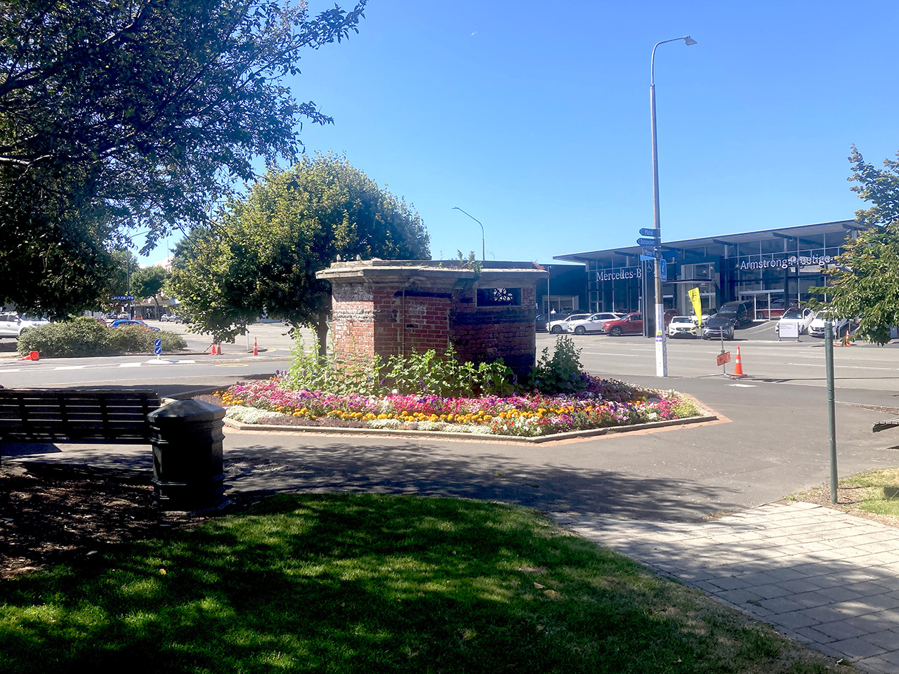
A small brick octagonal structure, the Manor Place Convenience was built by the Dunedin City Council (DCC)as a urinal in 1912. Designed by the Dunedin City Building Surveyor, G.W. Gough, it was built by contractor Augustine Ferry. Its sole use has been a public urinal from 1912 until its official closure to the public in 1976. During this time, it suffered from vandalism, the damage of which was routinely fixed by the DCC. It remains today within its original footprint, although it did have an additional substation structure adjacent to it from 1926-1958. It was briefly closed in 1958 as repairs were undertaken on the footings and drainage as a result of damage from the new adjacent underground substation. In 1963, after a spate of vandalism, two porcelain cisterns were replaced. In 1976, after a narrow escape from demolition, the urinal was used exclusively by DCC Transport bus drivers. This department offered it back to DCC in 1985 to be used again as a public toilet, however it never reopened with both entrances bricked up after this time. The interior was accessed in 2017, as DCC prepared a report on potential works on the structure.

The Manor Place Conveniences has become a small but prominent Dunedin city landmark, and is unique in New Zealand because of its original interior, its distinctive octagonal form, and as a rare example of an early 20th century urinal.
Manor Place Conveniences, Dunedin | Alison Breese | 01/02/2023 | Heritage New Zealand Pouhere Taonga
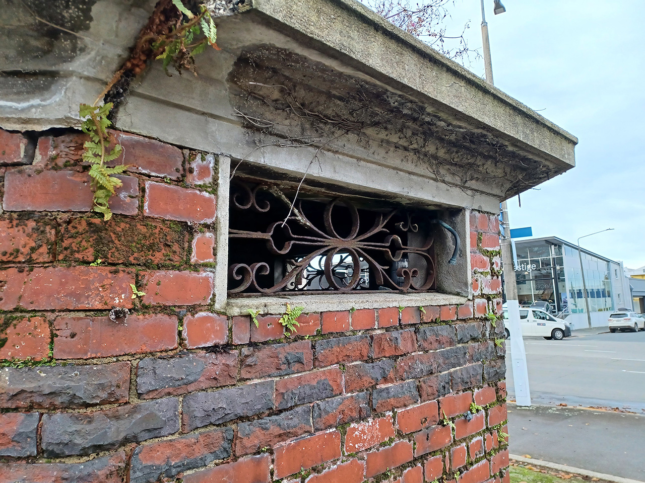
Manor Place Conveniences, Dunedin. Detail of Princes Street facing window | Sarah Gallagher | 18/05/2022 | Heritage New Zealand Pouhere Taonga
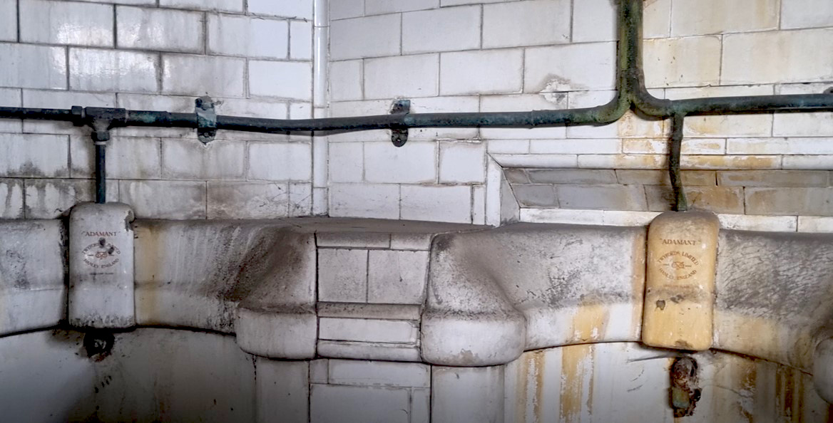
Manor Place Conveniences, Dunedin. interior view of Adamant urinals and wall tiles | Rebecca Collie | 18/05/2022 | Heritage New Zealand Pouhere Taonga
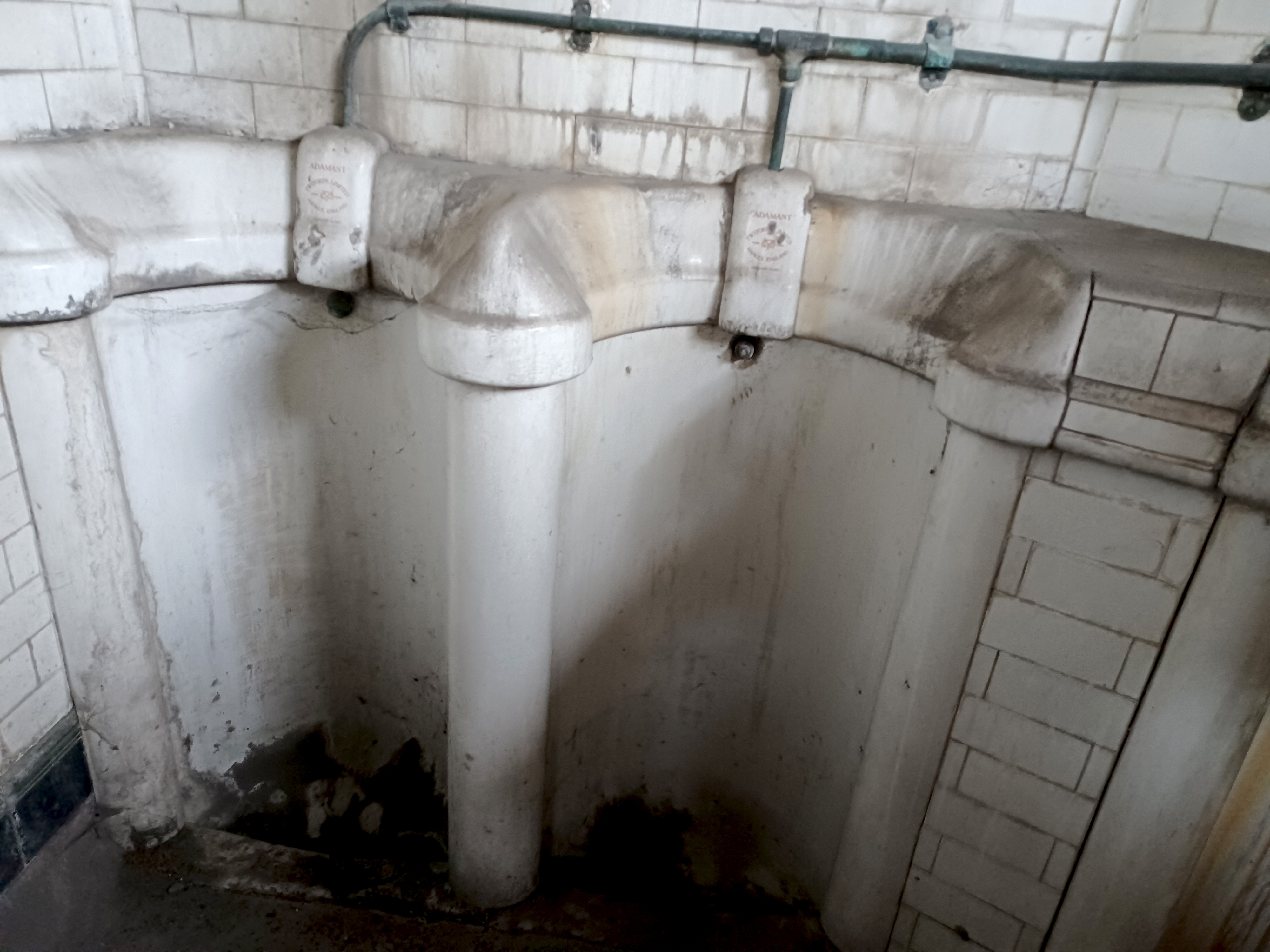
Manor Place Conveniences, Dunedin. interior view of urinals | Sarah Gallagher | 18/05/2022 | Heritage New Zealand Pouhere Taonga
Manor Place Conveniences, Dunedin | Alison Breese | 01/02/2023 | Heritage New Zealand Pouhere Taonga
Manor Place Conveniences, Dunedin. Detail of Princes Street facing window | Sarah Gallagher | 18/05/2022 | Heritage New Zealand Pouhere Taonga
Manor Place Conveniences, Dunedin. interior view of Adamant urinals and wall tiles | Rebecca Collie | 18/05/2022 | Heritage New Zealand Pouhere Taonga
Manor Place Conveniences, Dunedin. interior view of urinals | Sarah Gallagher | 18/05/2022 | Heritage New Zealand Pouhere Taonga

List Entry Information

Overview

Status
Listed

List Entry Status
Historic Place Category 2

Access
Private/No Public Access

List Number
9840

Date Entered
29th June 2023

Date of Effect
20th July 2023

City/District Council
Dunedin City

Region
Otago Region

Extent of List Entry

Extent includes part of the land described as Legal Road, Otago Land District and the building known as Manor Place Convenience, thereon. (Refer to map in Appendix 1 of the List entry report for further information).

Legal description

Legal Road, Otago Land District

Detailed List Entry
Significance

Historic Significance

Historical Significance or Value The small brick structure is an example of a once common public convenience. Over the decades, many of these conveniences have been upgraded- resulting in loss of historic material or demolished. Thus, Manor Place Convenience has become a rare surviving record of the major achievements and thinking of early 20th Century sanitation, public health, technology, and city design, as Dunedin followed international sanitation trends. The design of Manor Place follows sanitation trends around Europe as diseases like typhoid, cholera and the Bubonic Plague scare in 1901 led to cities trying to improve public facilities to stop spread of disease. There are no early 20th Century urinals like this left in New Zealand. The oldest convenience was built in 1880 and located at Grafton Bridge, Auckland and no longer has an original interior adding to the uniqueness of the preservation of the Manor Place urinal. It also maintains the historical alignment with the now demolished Dunedin underground conveniences across the city. The Manor Place convenience, in its original state can show how other Edwardian public conveniences were designed. The Manor Place Conveniences represent important changes in ideas of acceptable public behaviour and perceptions of public decency and health during the 20th century. They are evidence of the gendered structures that existed in the Victorian and Edwardian times. The public requested provision be made for both sexes at the Manor Place site but a men only urinal was built with the Council claiming a lack of money to build anything other than a simple structure. There was nowhere public in this area of Dunedin for women to relieve themselves at all, other than hotels, or department stores further along Princes Street.

Physical Significance

Archaeological Significance or Value The Manor Place Convenience has archaeological significance as it provides evidence of the now rare Edwardian public conveniences and sanitation in New Zealand. It provides the ability to use the structures archaeology to answer questions about the design and construction technique of these Edwardian public conveniences. As a completely original structure still in situ, the Manor Place Convenience offers a rare insight into these once common structures as they were originally built and used. Architectural Significance or Value The Manor Place Convenience has architectural significance. The urinal is a unique building with no other like it in New Zealand. It sits in the streetscape on the edge of the Market Reserve and is octagonal in shape, perhaps intentionally mirroring the Dunedin landmark of the Octagon or following the design of Berlin’s “Café Achteck” style. It is unusual in its design compared to other urinals at the time as many were simple rectangular brick and iron design or were being upgraded into more significant architectural styles such as the new underground conveniences, first built in Christchurch in 1908, followed by Dunedin in 1910. There are no other brick Edwardian style urinals with original interior fittings remaining in New Zealand and the octagonal form is unique to this convenience with no recorded evidence of its use elsewhere in New Zealand. The bus shelter and toilets in Symonds Street and Grafton Bridge, Auckland (List No. 561) were built two years earlier and although brick, it is significantly different in its design to Manor Place and has provision for men and women and incorporates a bus shelter. It has also been significantly modernised over the decades and has recently undergone restoration works and a seismic upgrade. The placement of the ‘Adamant’ urinal differs from both the Twyford catalogues and from other conveniences built in Dunedin and across New Zealand. This design was to incorporate as many urinals into the small space as possible. The internal layout and design have only received minor damage by vandals over the decades and has never been remodelled or upgraded. Technological Significance or Value The Manor Place Conveniences are physical evidence of what was forefront of sanitary architecture and design in Edwardian times. Twyford sanitary designs were world leading, and Dunedin was eager to follow worldwide trends in sanitation, keen to be known as a “modern” city. The site at Manor Place demonstrates the advancements in sanitation technology in Dunedin during the early 20th century, as a result the public health crisis of the outbreak of the Bubonic Plague in 1901 and is the only remaining example of this sanitary furniture.

Detail Of Assessed Criteria

(a) The extent to which the place reflects important or representative aspects of New Zealand history The Manor Place Conveniences reflect a once common, yet important, sanitary provision for the public. It is physical evidence of how local authorities provided sanitation facilities for the community in the 19th and 20th centuries. It tells the story of sanitation, hygiene and public urination in New Zealand and the gendered nature of the spaces. The history of the structure tells the story of local authorities struggle to provide and fund the facilities and the public views towards them. The Edwardian style of conveniences is rare in New Zealand and the Manor Place Convenience is an intact and rare example of this style of convenience in New Zealand. (b) The association of the place with events, persons, or ideas of importance in New Zealand history The Manor Place Convenience is evidence of the development of public sanitation in New Zealand and showcases how New Zealand strived to follow international sanitation trends to create “modern” cities. The convenience is an example of the change made in style, design, and provision of the public conveniences as Dunedin moved to modernise its reputation. The structure is also connected to the long demolished underground structures that were located across the city. These were a large undertaking in the central city, having the same interiors and contractor. As a result of the underground conveniences being funded and constructed by the local authority, the Manor Place Convenience remains as a physical link to these long-gone structures as well as a link to the contractor’s Ferry work. (f) The potential of the place for public education Manor Place Conveniences is an example of a lost style of public facility that was established in New Zealand to follow international sanitation trends. It also shows the gendered nature of the facilities and is an example of the lack of provision of women’s facilities. It raises awareness of the history behind public sanitation in New Zealand as well as the attitudes and methods around authorities dealing with diseases and hygiene. While it has not been accessible for several decades, the structure itself is highly visible, located on a busy intersection. Following public consultation, it was clear the public know of the structure but perhaps not unsurprisingly (as it has been bricked up for 40 years) do not know it is/was a public convenience. The structure also provides the ability to use the structures archaeology to answer questions about the design and construction technique of these Edwardian public conveniences. (j) The importance of identifying rare types of historic places The Manor Place Conveniences is a rare type of structure. The brick material was unusual for New Zealand with many councils opting for inexpensive cast iron urinals and the octagonal design is not replicated anywhere in New Zealand. The original interior is also unusual as most public facilities were part of ongoing upgrades and maintenance over the decades, leading to most facilities losing their original 1910-1920 interiors. Although there have been very minor repairs to some of the porcelain and the concrete floor, and the two cisterns have been replaced, the interior has never been modernised. The original decoration of the art nouveau style acanthus leaf tiles is a particularly rare feature as is the unique shape and interior design and possible link to the Octagon design in Central Dunedin. (k) The extent to which the place forms part of a wider historical and cultural area The Manor Place Convenience and the previous urinal on the site have been part of the wider historic area of Manor Place and Market Reserve since 1874. The Market Reserve was home to many public events (particularly circuses) over the years as well as a public reserve. The area has always been a well frequented area, with many industries and hotels in the area. Many buildings and residences along Manor Place are heritage listed including the Crown Milling Company Building (List No 366), the HE Shacklock Buildings (List No 2160). Summary of Significance or Values The Manor Place Convenience is a rare structure of architectural and historical significance which has public education and archaeological value around early sanitation in New Zealand. Built in 1912, it is historically important physical evidence of a once common convenience and is a rare example of early twentieth century responses to improve sanitation. It tells the story of sanitation and hygiene in New Zealand and demonstrates important changes in ideas of acceptable behaviour and perceptions of public health in the early 20th century. The structure provides evidence of gendered public facilities in New Zealand. The Manor Place Convenience is a small but prominent Dunedin city landmark, not only for its distinctive octagonal design but also because its integrity has remained largely intact since it closed as public toilets in 1976. Its design is unique with no other urinals being built in the same design and materials in New Zealand.

Construction Professional

Name

Ferry, A

Type

Builder

Name

Gough, George William

Type

Architect

Biography

George William Gough (1863-1936) Gough was born in Manchester and studied naval architecture under R. Napier and Sons, ship builders in Glasgow and under Messrs D & W Henderson and Co., owners of the Anchor Line. He also Completed an apprenticeship in civil architecture under George Melrose of Rothesay and studied architecture in both Canada and the United States of America. In 1886 he came to New Zealand, where he designed and constructed the S.S. Tarawera for tourist traffic on Lake Te Anau. In conjunction with Mr E. Roberts, he built the stern-wheel steamer Clyde on the Molyneux, as well as other craft. He also designed several industrial premises (including May’s Confectionary Works), many elaborately decorated villas, and a house for the superintendent of the Botanic Garden. He was a fellow of the New Zealand Institute of Architects.

Construction Details

Start Year

2017

Type

Modification

Description

North bricked up door taken down for interior access

Start Year

1912

Type

Original Construction

Start Year

1926

Type

Additional building added to site

Description

Substation built behind the structure

Start Year

1929

Type

Modification

Description

Iron Railing removed

Start Year

1940

Type

Maintenance/repairs

Description

Broken coping and porcelain at stalls repaired, fences, gates and ventilation bars painted. Iron railing removed

Start Year

1958

Type

Modification

Description

Substation removed from behind convenience and underground one built beside – compromised the footings of the Convenience. Drainage repaired through concrete floor.

Start Year

1963

Type

Damaged

Description

Significant Vandalism occurred

Start Year

1976

Type

Other

Description

Decommissioned

Start Year

1985

Type

Other

Description

Offered back to Dunedin City Council as a public toilet

Construction Materials

Brick, concrete, wrought iron, tile and ceramic, fireclay pottery

Historical Narrative

Both iwi history and archaeological evidence show Māori occupation in the Ōtākou Otago region over an extended period, with the inhabitants utilising a wide variety of natural resources from the diverse environment. Archaeological evidence supports the date of earliest settlement around the 12th century. Today, Kāi Tahu mana whenua is recognised over a large part of Te Wai Pounamu. Kāti Māmoe and Waitaha whakapapa and shared occupation are always acknowledged. Tūpuna such as Waitai, Tukiauau, Whaka-taka-newha, Rakiiamoa, Tarewai, Maru, Te Aparangi, Taoka, Moki II, Kapo, Te Wera, Tu Wiri Roa, Taikawa, and Te Hautapanuiotu are among Kāti Māmoe and Kāi Tahu tūpuna whose feats and memories are embedded in the landscape, bays, tides and whakapapa of Ōtākou Otago. The hapū Kai Te Pahi, Kāti Moki, and Kāti Taoka still maintain their presence and responsibility as kaitiaki in this region. While not as densely populated as the North Island, numerous kaik in the Ōtākou region still hosted a good number of Waitaha, Kāti Mamoe and later Kāi Tahu peoples. Various bays and beaches around the Tairaoa Heads supported several hundred people with kaik in Karitāne, Waikouaiti and at the mouth of the Mata-au or Clutha hosting a similar number. Pā kāinga on the Ōtākou coast included Māpoutahi (Pūrākaunui), Pukekura (Taiaroa Head), Kōpūtai, Huriawa and Moturata (Taieri Island). Whareakeake, one of several pounamu manufacturing sites, attested to another facet of lifestyle for the artisans of the iwi. Historically, Kāi Tahu and previous tangata whenua Waitaha and Kati Māmoe used the tauraka waka (landing site) at Ōtepoti (Dunedin city) when they visited the head of the Ōtākou harbour as either the gateway to the route to Kaikarae (Green Island) or on other mahinga kai expeditions. The soft slope of the foreshore and the tidal flats in the upper harbour where the small stream, Toitū, entered the sea was bisected by a prominent hill Ngā-moana-e-rua (called Bell Hill by colonists), the foot of which lay at the very edge of the high water mark. No permanent kaik or villages were situated at the mouth of the Toitū, as there was no need for it. While the population numbers are still debated by academics and historians, there is no argument that through epidemics and intertribal warfare, the numbers of Kāi Tahu living in the region had dwindled considerably by the time the Treaty of Waitangi was signed at Ōtakou (Otago Heads), 13 June 1840. The Manor Place Convenience site was originally part of the foreshore. In 1852 a strip of land between Princes Street and Manor Place on this foreshore was chosen by the Government for Māori Reserve. Previously, the Toitū tauraka waka landing site was a place of early interactions with European colonists and it became a well-known as the Ōtākou Kai Tahu trading site with colonial settlers. However, while requested as a Māori Reserve, this site was not reserved and instead the area of land, near the Convenience site, was utilised as storage for building material for a short time; eventually being withdrawn by the Government from Māori. McDonald notes that there was an agreement made to the chiefs in 1844 at the time of the Otago Block regarding land at the head of the harbour. Topi requested a site at the Toitū tauraka waka and land at the ‘sandy cove to the east afterwards occupied by a manse.’ In November 1852, the Colonial Secretary at the time, Alfred Dommet, requested Walter Mantell, Government Land Purchase Agent, to recommend the strip of land between Princes Street and the Harbour from Jetty Street to Manor Place to be reserved for Māori accommodation when visiting Dunedin. However, this land had already been reserved by Captain Cargill as a reserve to protect the waterfront in 1848. A lack of proclamation by Mantell led to confusion and the Provincial Government placed immigration and police barracks on the site north along Princes Street where the Native Reserve was recommended to be. A Crown Grant was issued for the land to be used for public utilities, known as the ‘Princes Street Reserve’ in 1868 and included a small Native Reserve. In 1872 an agreement was formed to reimburse Māori £5000 ($822,291), a sum agreed to by Taiaroa and Topi, the Provincial Government and City Corporation. This compensation to Māori was never honoured. European Settlement - Sanitation and Sewerage With the arrival of the Scottish Free Church settlers in 1848, the small village of Dunedin was established. Infrastructure was slow to develop with very few resources available. The Dunedin Town Board was established in 1855 (predecessors to the Dunedin City Council) and along with the Otago Provincial Council funding, began to establish culverts and roads. While the town slowly started to develop, the discovery of gold in 1861 by Gabriel Read at Central Otago, resulted in a gold rush with an explosive impact on the burgeoning township. People flocked to Central Otago from over the world, passing through Dunedin in the hopes of making it rich on the goldfields. Dunedin, with a lack of infrastructure to match the onslaught of people and industry, was described as a filthy, dirty place. In 1864 the Superintendent of Otago appointed a group to investigate the sanitary condition of the town and the Sanitary Commission was created. The first sewer and culvert was built down Rattray Street in 1861 but it was not until 1872 that the City Surveyor Samuel Heywood Mirams planned a systematic drainage scheme with large brick sewers which flowed out into the harbour. Discussion around underground drainage occupied the City Council’s meeting discussions during the 1870s and became an election promise for those candidates running for Council. Cholera and typhoid were diseases that plagued Europe and were on the rise in Dunedin. Underground sewers in central Dunedin were proposed. "If this work," wrote a correspondent, "be not attended to before the warm weather sets in, the consequences that must follow from any epidemic breaking out in the city, will no doubt be chargeable to the wilful negligence of the Corporation”. Large brick sewers were built under the main streets of Dunedin to meet the new sanitation standards in 1877 which was completed by 1912.

Physical Description

Current Description The Manor Place Convenience is located on the edge of the Market Reserve, on the corner of Princes Street South and Manor Place. It previously was a separate piece of land forming an island within the road system but has been incorporated into the reserve itself with footpath around it. The urinal maintains the original footprint and is surrounded by an octagonal garden bed. It is an octagonal, brick structure set at ground level, one-storey in height with a flat concrete roof and a deep, overhanging, moulded coping of concrete. The brick elevations, with 26 visible courses, features two bands of slightly darker-coloured, rusticated brick that break the monotony of the red brick facades. The bricks are laid in English Garden Wall bond with the rusticated bricks laid in Stretcher bond, and though unconfirmed, the mortar appears to be a cement mortar. Once covered in ivy, this has been removed and various weeds, ferns and moss have grown on the structure, and there is visible evidence of water ingress/egress on the walls in the western section of the structure. The eastern side, facing Manor Place, has remnants of white paint, possibly from the substation that was attached from 1926-1958. An electrical pillar box for connection to mains power is located at ground level on the west elevation. Ad-hoc electrical fixtures can be seen on the roof and include a disused electrical insulator, a bracket for a former light, an aerial for a meter and an electrical conduit from the pillar box. There is a substantial, partially open crack through the brick masonry in the south elevation panel adjacent to the south screened opening. The structure has an entrance and exit corridor with a small locker on the southern side. Behind the wooden door into the locker there is an etched date of “12/12/12” in the concrete, presumably by one of the original contractors. One entrance on the southern side was bricked up possibly from the early 1960s and the other north facing entrance was bricked up sometime after 1985 (nothing has been found in archives about this work). The north facing entrance was opened by removing the recent bricks in 2017 to gain access for Dunedin City Council to assess potential work on the space. The structure has three narrow rectangular ventilation openings inlaid with a decorative iron grid of floral and circular patterns. The inside of the northern ventilation opening has additional iron bars across the inside of the opening. The interior is clad in white “Forite” tiles with a green dado and a green ornamental art nouveau frieze along the top of the walls. There are eight urinals that were purchased in a set that have been inlaid around the inside of the octagonal structure with two cisterns. The interior has never been modernised with only minor repairs occurring to rectify damage from subsidence and vandalism. The original Adamant fireclay urinal is still present as is the original wall tiles, decorative frieze and dado. The removal and subsequent placing of an underground substation next to the structure resulted in some damage due to ground subsidence under some of the urinal’s footings. The concrete floor was broken in 1958 for the remediation of broken drainage pipes. Large cracks are prominent and seen from both the interior and exterior on the Princes Street side (southwest side) and the urinals have split at the joins. The decorative tiling is cracked in several places but predominately has remained intact although separated from the concrete roof. The interior walls have shifted, approximately 10cm, from their original placement and many are no longer be level. The cisterns are possibly from 1963 as they were replaced when a porcelain one was damaged; the previous brackets holes remain. There are small rough repairs to the fireclay urinals. Comparative Analysis The Manor Place Conveniences can be compared to other urinals and conveniences across New Zealand. There are two Public Conveniences listed on Heritage New Zealand Pouhere Taonga’s Rārangi Kōrero – the Bus Shelter and Toilets (List No. 561) at Symonds Street, Auckland, and the ‘Taj Mahal’ Public Toilets (Former) (List No. 1434), Wellington. Neither of these are a urinal or like the Manor Place structure. Two unlisted historic toilets are the Cast Iron Urinal in Masterton, being more relocatable it has been refurbished and moved several times, and the former Courtney Place Men’s Toilets in Wellington are reused as a pizza restaurant. This public convenience built in 1910 catered for men and women and also featured a tram stop. These were built two years earlier and although brick, it is significantly different in its design to Manor Place. The interiors have similar white tiles to the Manor Place urinal, although are square rather than rectangular in shape. It has also been significantly modernised over the decades and has recently undergone restoration works and a seismic upgrade in 2022. The ‘Taj Mahal’ was built as a public toilet in 1928–29 and was bestowed its popular name from the distinctive domes at either end, reminiscent of the great Taj Mahal. It was designed by the City Engineer’s office and built by Fletcher Construction. Unlike other public conveniences built at the time, this building was constructed above ground, and was part of a series of interesting public utilities designed by the Wellington City Corporation. The convenience is rendered in reinforced concrete with a tiled mosaic floor and a Malthoid roof covering. Similarities with Manor Place are that is above ground, single storey with a semi-circular row of urinals at the south end, it differs from Manor Place in its materials and the fact it was built for both men and women. The toilets closed in 1966 and since then has served multiple purposes including: storage, theatre workshops, art gallery and restaurant. The cast iron urinal in Masterton was refurbished in 2012 after being in storage for many years. No longer in its original position on the main street, it was relocated to Masterton Park and is believed to have been built in the early 1900s. As this was built of cast iron it was easy to move around unlike the permanent Manor Place brick structure. Many councils opted to have the cast iron style as it was inexpensive and could be easily shifted. However, Dunedin City Council chose to build a brick one with the last of special funds money that had been allocated and used for the underground conveniences, in the Octagon, Customhouse Square, and London Street. The first iron public urinal manufactured in New Zealand was by Mr J. Storrier in 1903. The former Courtenay Place Men’s Toilets are a good representative example of a utilitarian, local authority, Edwardian building. They were built in 1910, two years before Manor Place Convenience and they were semi-underground. The walls were constructed in brick with a concrete roof on steel joints. All walls, floor, and roof were covered with mineral asphalt with the floors also being coated with red arkilite. The toilets were more substantial than the Manor Place Convenience as it included six urinals, three toilets and an attendant’s room. They were closed in 1994 after many years of complaints, making them one of the last underground toilets remaining in New Zealand. In 2011 the space was leased and developed into a pizza and gelato kiosk. All interiors were removed, and the cast iron fences, and the prismatic skylights were preserved by the Wellington City Council.

Reference

Completion Date

30th November 2022

Report Written By

Alison Breese and Sarah Gallagher

Information Sources

Daley, 2000

Caroline Daley, ‘Flushed with Pride? Women’s Quest for Public Toilets in New Zealand’, Women’s Studies Journal, 2000, 16(1)

Auckland City Council, 2015

‘Caught Short: A Brief History of Auckland’s Heritage Toilets’. Auckland, 2015.

Breese, Alison, 2019

How Convenient Are the Conveniences? The demise of the underground facilities in Dunedin 1910-1980s, MA Thesis, University of Otago, 2019

Brickell, Chris, 2012

Brickell, Chris., ‘“Waiting for Uncle Ben”: Age-Structured Homosexuality in New Zealand, 1920–1950’. Journal of the History of Sexuality, Vol. 21, No. 3, September 2012

Report Written By

Please note that entry on the New Zealand Heritage List/Rarangi Korero identifies only the heritage values of the property concerned, and should not be construed as advice on the state of the property, or as a comment of its soundness or safety, including in regard to earthquake risk, safety in the event of fire, or insanitary conditions. A fully referenced New Zealand Heritage List report is available on request from the Otago Southland Area Office of Heritage New Zealand Pouhere Taonga.

Further Information

Current Usages

Former Usages

General Usage:: Civic Facilities

Specific Usage: Public Lavatory

Themes

Web Links

description: How Convenient are our Conveniences? The demise of the underground facilities in Dunedin 1910-1980s.

url: https://scalar.usc.edu/works/conveniences/introduction.

Overview

Status

Listed

List Entry Status

Historic Place Category 2

Access

Private/No Public Access

List Number

9840

Date Entered

29th June 2023

Date of Effect

20th July 2023

City/District Council

Dunedin City

Region

Otago Region

Extent of List Entry

Extent includes part of the land described as Legal Road, Otago Land District and the building known as Manor Place Convenience, thereon. (Refer to map in Appendix 1 of the List entry report for further information).

Legal description

Legal Road, Otago Land District

Status

Listed

List Entry Status

Historic Place Category 2

Access

Private/No Public Access

List Number

9840

Date Entered

29th June 2023

Date of Effect

20th July 2023

City/District Council

Dunedin City

Region

Otago Region

Extent of List Entry

Extent includes part of the land described as Legal Road, Otago Land District and the building known as Manor Place Convenience, thereon. (Refer to map in Appendix 1 of the List entry report for further information).

Legal description

Legal Road, Otago Land District

Significance

Why is this place significant?

Historic Significance

Historical Significance or Value The small brick structure is an example of a once common public convenience. Over the decades, many of these conveniences have been upgraded- resulting in loss of historic material or demolished. Thus, Manor Place Convenience has become a rare surviving record of the major achievements and thinking of early 20th Century sanitation, public health, technology, and city design, as Dunedin followed international sanitation trends. The design of Manor Place follows sanitation trends around Europe as diseases like typhoid, cholera and the Bubonic Plague scare in 1901 led to cities trying to improve public facilities to stop spread of disease. There are no early 20th Century urinals like this left in New Zealand. The oldest convenience was built in 1880 and located at Grafton Bridge, Auckland and no longer has an original interior adding to the uniqueness of the preservation of the Manor Place urinal. It also maintains the historical alignment with the now demolished Dunedin underground conveniences across the city. The Manor Place convenience, in its original state can show how other Edwardian public conveniences were designed. The Manor Place Conveniences represent important changes in ideas of acceptable public behaviour and perceptions of public decency and health during the 20th century. They are evidence of the gendered structures that existed in the Victorian and Edwardian times. The public requested provision be made for both sexes at the Manor Place site but a men only urinal was built with the Council claiming a lack of money to build anything other than a simple structure. There was nowhere public in this area of Dunedin for women to relieve themselves at all, other than hotels, or department stores further along Princes Street.

Physical Significance

Archaeological Significance or Value The Manor Place Convenience has archaeological significance as it provides evidence of the now rare Edwardian public conveniences and sanitation in New Zealand. It provides the ability to use the structures archaeology to answer questions about the design and construction technique of these Edwardian public conveniences. As a completely original structure still in situ, the Manor Place Convenience offers a rare insight into these once common structures as they were originally built and used. Architectural Significance or Value The Manor Place Convenience has architectural significance. The urinal is a unique building with no other like it in New Zealand. It sits in the streetscape on the edge of the Market Reserve and is octagonal in shape, perhaps intentionally mirroring the Dunedin landmark of the Octagon or following the design of Berlin’s “Café Achteck” style. It is unusual in its design compared to other urinals at the time as many were simple rectangular brick and iron design or were being upgraded into more significant architectural styles such as the new underground conveniences, first built in Christchurch in 1908, followed by Dunedin in 1910. There are no other brick Edwardian style urinals with original interior fittings remaining in New Zealand and the octagonal form is unique to this convenience with no recorded evidence of its use elsewhere in New Zealand. The bus shelter and toilets in Symonds Street and Grafton Bridge, Auckland (List No. 561) were built two years earlier and although brick, it is significantly different in its design to Manor Place and has provision for men and women and incorporates a bus shelter. It has also been significantly modernised over the decades and has recently undergone restoration works and a seismic upgrade. The placement of the ‘Adamant’ urinal differs from both the Twyford catalogues and from other conveniences built in Dunedin and across New Zealand. This design was to incorporate as many urinals into the small space as possible. The internal layout and design have only received minor damage by vandals over the decades and has never been remodelled or upgraded. Technological Significance or Value The Manor Place Conveniences are physical evidence of what was forefront of sanitary architecture and design in Edwardian times. Twyford sanitary designs were world leading, and Dunedin was eager to follow worldwide trends in sanitation, keen to be known as a “modern” city. The site at Manor Place demonstrates the advancements in sanitation technology in Dunedin during the early 20th century, as a result the public health crisis of the outbreak of the Bubonic Plague in 1901 and is the only remaining example of this sanitary furniture.

Why is this place Category 1 / Category 2?

Detail Of Assessed Criteria

(a) The extent to which the place reflects important or representative aspects of New Zealand history The Manor Place Conveniences reflect a once common, yet important, sanitary provision for the public. It is physical evidence of how local authorities provided sanitation facilities for the community in the 19th and 20th centuries. It tells the story of sanitation, hygiene and public urination in New Zealand and the gendered nature of the spaces. The history of the structure tells the story of local authorities struggle to provide and fund the facilities and the public views towards them. The Edwardian style of conveniences is rare in New Zealand and the Manor Place Convenience is an intact and rare example of this style of convenience in New Zealand. (b) The association of the place with events, persons, or ideas of importance in New Zealand history The Manor Place Convenience is evidence of the development of public sanitation in New Zealand and showcases how New Zealand strived to follow international sanitation trends to create “modern” cities. The convenience is an example of the change made in style, design, and provision of the public conveniences as Dunedin moved to modernise its reputation. The structure is also connected to the long demolished underground structures that were located across the city. These were a large undertaking in the central city, having the same interiors and contractor. As a result of the underground conveniences being funded and constructed by the local authority, the Manor Place Convenience remains as a physical link to these long-gone structures as well as a link to the contractor’s Ferry work. (f) The potential of the place for public education Manor Place Conveniences is an example of a lost style of public facility that was established in New Zealand to follow international sanitation trends. It also shows the gendered nature of the facilities and is an example of the lack of provision of women’s facilities. It raises awareness of the history behind public sanitation in New Zealand as well as the attitudes and methods around authorities dealing with diseases and hygiene. While it has not been accessible for several decades, the structure itself is highly visible, located on a busy intersection. Following public consultation, it was clear the public know of the structure but perhaps not unsurprisingly (as it has been bricked up for 40 years) do not know it is/was a public convenience. The structure also provides the ability to use the structures archaeology to answer questions about the design and construction technique of these Edwardian public conveniences. (j) The importance of identifying rare types of historic places The Manor Place Conveniences is a rare type of structure. The brick material was unusual for New Zealand with many councils opting for inexpensive cast iron urinals and the octagonal design is not replicated anywhere in New Zealand. The original interior is also unusual as most public facilities were part of ongoing upgrades and maintenance over the decades, leading to most facilities losing their original 1910-1920 interiors. Although there have been very minor repairs to some of the porcelain and the concrete floor, and the two cisterns have been replaced, the interior has never been modernised. The original decoration of the art nouveau style acanthus leaf tiles is a particularly rare feature as is the unique shape and interior design and possible link to the Octagon design in Central Dunedin. (k) The extent to which the place forms part of a wider historical and cultural area The Manor Place Convenience and the previous urinal on the site have been part of the wider historic area of Manor Place and Market Reserve since 1874. The Market Reserve was home to many public events (particularly circuses) over the years as well as a public reserve. The area has always been a well frequented area, with many industries and hotels in the area. Many buildings and residences along Manor Place are heritage listed including the Crown Milling Company Building (List No 366), the HE Shacklock Buildings (List No 2160). Summary of Significance or Values The Manor Place Convenience is a rare structure of architectural and historical significance which has public education and archaeological value around early sanitation in New Zealand. Built in 1912, it is historically important physical evidence of a once common convenience and is a rare example of early twentieth century responses to improve sanitation. It tells the story of sanitation and hygiene in New Zealand and demonstrates important changes in ideas of acceptable behaviour and perceptions of public health in the early 20th century. The structure provides evidence of gendered public facilities in New Zealand. The Manor Place Convenience is a small but prominent Dunedin city landmark, not only for its distinctive octagonal design but also because its integrity has remained largely intact since it closed as public toilets in 1976. Its design is unique with no other urinals being built in the same design and materials in New Zealand.

Why is this place significant?

Historic Significance

Historical Significance or Value The small brick structure is an example of a once common public convenience. Over the decades, many of these conveniences have been upgraded- resulting in loss of historic material or demolished. Thus, Manor Place Convenience has become a rare surviving record of the major achievements and thinking of early 20th Century sanitation, public health, technology, and city design, as Dunedin followed international sanitation trends. The design of Manor Place follows sanitation trends around Europe as diseases like typhoid, cholera and the Bubonic Plague scare in 1901 led to cities trying to improve public facilities to stop spread of disease. There are no early 20th Century urinals like this left in New Zealand. The oldest convenience was built in 1880 and located at Grafton Bridge, Auckland and no longer has an original interior adding to the uniqueness of the preservation of the Manor Place urinal. It also maintains the historical alignment with the now demolished Dunedin underground conveniences across the city. The Manor Place convenience, in its original state can show how other Edwardian public conveniences were designed. The Manor Place Conveniences represent important changes in ideas of acceptable public behaviour and perceptions of public decency and health during the 20th century. They are evidence of the gendered structures that existed in the Victorian and Edwardian times. The public requested provision be made for both sexes at the Manor Place site but a men only urinal was built with the Council claiming a lack of money to build anything other than a simple structure. There was nowhere public in this area of Dunedin for women to relieve themselves at all, other than hotels, or department stores further along Princes Street.

Physical Significance

Archaeological Significance or Value The Manor Place Convenience has archaeological significance as it provides evidence of the now rare Edwardian public conveniences and sanitation in New Zealand. It provides the ability to use the structures archaeology to answer questions about the design and construction technique of these Edwardian public conveniences. As a completely original structure still in situ, the Manor Place Convenience offers a rare insight into these once common structures as they were originally built and used. Architectural Significance or Value The Manor Place Convenience has architectural significance. The urinal is a unique building with no other like it in New Zealand. It sits in the streetscape on the edge of the Market Reserve and is octagonal in shape, perhaps intentionally mirroring the Dunedin landmark of the Octagon or following the design of Berlin’s “Café Achteck” style. It is unusual in its design compared to other urinals at the time as many were simple rectangular brick and iron design or were being upgraded into more significant architectural styles such as the new underground conveniences, first built in Christchurch in 1908, followed by Dunedin in 1910. There are no other brick Edwardian style urinals with original interior fittings remaining in New Zealand and the octagonal form is unique to this convenience with no recorded evidence of its use elsewhere in New Zealand. The bus shelter and toilets in Symonds Street and Grafton Bridge, Auckland (List No. 561) were built two years earlier and although brick, it is significantly different in its design to Manor Place and has provision for men and women and incorporates a bus shelter. It has also been significantly modernised over the decades and has recently undergone restoration works and a seismic upgrade. The placement of the ‘Adamant’ urinal differs from both the Twyford catalogues and from other conveniences built in Dunedin and across New Zealand. This design was to incorporate as many urinals into the small space as possible. The internal layout and design have only received minor damage by vandals over the decades and has never been remodelled or upgraded. Technological Significance or Value The Manor Place Conveniences are physical evidence of what was forefront of sanitary architecture and design in Edwardian times. Twyford sanitary designs were world leading, and Dunedin was eager to follow worldwide trends in sanitation, keen to be known as a “modern” city. The site at Manor Place demonstrates the advancements in sanitation technology in Dunedin during the early 20th century, as a result the public health crisis of the outbreak of the Bubonic Plague in 1901 and is the only remaining example of this sanitary furniture.

Why is this place Category 1 / Category 2?

Detail Of Assessed Criteria

(a) The extent to which the place reflects important or representative aspects of New Zealand history The Manor Place Conveniences reflect a once common, yet important, sanitary provision for the public. It is physical evidence of how local authorities provided sanitation facilities for the community in the 19th and 20th centuries. It tells the story of sanitation, hygiene and public urination in New Zealand and the gendered nature of the spaces. The history of the structure tells the story of local authorities struggle to provide and fund the facilities and the public views towards them. The Edwardian style of conveniences is rare in New Zealand and the Manor Place Convenience is an intact and rare example of this style of convenience in New Zealand. (b) The association of the place with events, persons, or ideas of importance in New Zealand history The Manor Place Convenience is evidence of the development of public sanitation in New Zealand and showcases how New Zealand strived to follow international sanitation trends to create “modern” cities. The convenience is an example of the change made in style, design, and provision of the public conveniences as Dunedin moved to modernise its reputation. The structure is also connected to the long demolished underground structures that were located across the city. These were a large undertaking in the central city, having the same interiors and contractor. As a result of the underground conveniences being funded and constructed by the local authority, the Manor Place Convenience remains as a physical link to these long-gone structures as well as a link to the contractor’s Ferry work. (f) The potential of the place for public education Manor Place Conveniences is an example of a lost style of public facility that was established in New Zealand to follow international sanitation trends. It also shows the gendered nature of the facilities and is an example of the lack of provision of women’s facilities. It raises awareness of the history behind public sanitation in New Zealand as well as the attitudes and methods around authorities dealing with diseases and hygiene. While it has not been accessible for several decades, the structure itself is highly visible, located on a busy intersection. Following public consultation, it was clear the public know of the structure but perhaps not unsurprisingly (as it has been bricked up for 40 years) do not know it is/was a public convenience. The structure also provides the ability to use the structures archaeology to answer questions about the design and construction technique of these Edwardian public conveniences. (j) The importance of identifying rare types of historic places The Manor Place Conveniences is a rare type of structure. The brick material was unusual for New Zealand with many councils opting for inexpensive cast iron urinals and the octagonal design is not replicated anywhere in New Zealand. The original interior is also unusual as most public facilities were part of ongoing upgrades and maintenance over the decades, leading to most facilities losing their original 1910-1920 interiors. Although there have been very minor repairs to some of the porcelain and the concrete floor, and the two cisterns have been replaced, the interior has never been modernised. The original decoration of the art nouveau style acanthus leaf tiles is a particularly rare feature as is the unique shape and interior design and possible link to the Octagon design in Central Dunedin. (k) The extent to which the place forms part of a wider historical and cultural area The Manor Place Convenience and the previous urinal on the site have been part of the wider historic area of Manor Place and Market Reserve since 1874. The Market Reserve was home to many public events (particularly circuses) over the years as well as a public reserve. The area has always been a well frequented area, with many industries and hotels in the area. Many buildings and residences along Manor Place are heritage listed including the Crown Milling Company Building (List No 366), the HE Shacklock Buildings (List No 2160). Summary of Significance or Values The Manor Place Convenience is a rare structure of architectural and historical significance which has public education and archaeological value around early sanitation in New Zealand. Built in 1912, it is historically important physical evidence of a once common convenience and is a rare example of early twentieth century responses to improve sanitation. It tells the story of sanitation and hygiene in New Zealand and demonstrates important changes in ideas of acceptable behaviour and perceptions of public health in the early 20th century. The structure provides evidence of gendered public facilities in New Zealand. The Manor Place Convenience is a small but prominent Dunedin city landmark, not only for its distinctive octagonal design but also because its integrity has remained largely intact since it closed as public toilets in 1976. Its design is unique with no other urinals being built in the same design and materials in New Zealand.

Construction Information

Construction Professional

Name

Ferry, A

Type

Builder

Biography

Name

Gough, George William

Type

Architect

Biography

George William Gough (1863-1936) Gough was born in Manchester and studied naval architecture under R. Napier and Sons, ship builders in Glasgow and under Messrs D & W Henderson and Co., owners of the Anchor Line. He also Completed an apprenticeship in civil architecture under George Melrose of Rothesay and studied architecture in both Canada and the United States of America. In 1886 he came to New Zealand, where he designed and constructed the S.S. Tarawera for tourist traffic on Lake Te Anau. In conjunction with Mr E. Roberts, he built the stern-wheel steamer Clyde on the Molyneux, as well as other craft. He also designed several industrial premises (including May’s Confectionary Works), many elaborately decorated villas, and a house for the superintendent of the Botanic Garden. He was a fellow of the New Zealand Institute of Architects.

Construction Details

Start Year

2017

Type

Modification

Description

North bricked up door taken down for interior access

Start Year

1912

Type

Original Construction

Start Year

1926

Type

Additional building added to site

Description

Substation built behind the structure

Start Year

1929

Type

Modification

Description

Iron Railing removed

Start Year

1940

Type

Maintenance/repairs

Description

Broken coping and porcelain at stalls repaired, fences, gates and ventilation bars painted. Iron railing removed

Start Year

1958

Type

Modification

Description

Substation removed from behind convenience and underground one built beside – compromised the footings of the Convenience. Drainage repaired through concrete floor.

Start Year

1963

Type

Damaged

Description

Significant Vandalism occurred

Start Year

1976

Type

Other

Description

Decommissioned

Start Year

1985

Type

Other

Description

Offered back to Dunedin City Council as a public toilet

Construction Materials

Brick, concrete, wrought iron, tile and ceramic, fireclay pottery

Construction Professional

Name

Ferry, A

Type

Builder

Biography

Name

Gough, George William

Type

Architect

Biography

George William Gough (1863-1936) Gough was born in Manchester and studied naval architecture under R. Napier and Sons, ship builders in Glasgow and under Messrs D & W Henderson and Co., owners of the Anchor Line. He also Completed an apprenticeship in civil architecture under George Melrose of Rothesay and studied architecture in both Canada and the United States of America. In 1886 he came to New Zealand, where he designed and constructed the S.S. Tarawera for tourist traffic on Lake Te Anau. In conjunction with Mr E. Roberts, he built the stern-wheel steamer Clyde on the Molyneux, as well as other craft. He also designed several industrial premises (including May’s Confectionary Works), many elaborately decorated villas, and a house for the superintendent of the Botanic Garden. He was a fellow of the New Zealand Institute of Architects.

Construction Details

Start Year

2017

Type

Modification

Description

North bricked up door taken down for interior access

Start Year

1912

Type

Original Construction

Start Year

1926

Type

Additional building added to site

Description

Substation built behind the structure

Start Year

1929

Type

Modification

Description

Iron Railing removed

Start Year

1940

Type

Maintenance/repairs

Description

Broken coping and porcelain at stalls repaired, fences, gates and ventilation bars painted. Iron railing removed

Start Year

1958

Type

Modification

Description

Substation removed from behind convenience and underground one built beside – compromised the footings of the Convenience. Drainage repaired through concrete floor.

Start Year

1963

Type

Damaged

Description

Significant Vandalism occurred

Start Year

1976

Type

Other

Description

Decommissioned

Start Year

1985

Type

Other

Description

Offered back to Dunedin City Council as a public toilet

Construction Materials

Brick, concrete, wrought iron, tile and ceramic, fireclay pottery

Historical Narrative

Both iwi history and archaeological evidence show Māori occupation in the Ōtākou Otago region over an extended period, with the inhabitants utilising a wide variety of natural resources from the diverse environment. Archaeological evidence supports the date of earliest settlement around the 12th century. Today, Kāi Tahu mana whenua is recognised over a large part of Te Wai Pounamu. Kāti Māmoe and Waitaha whakapapa and shared occupation are always acknowledged. Tūpuna such as Waitai, Tukiauau, Whaka-taka-newha, Rakiiamoa, Tarewai, Maru, Te Aparangi, Taoka, Moki II, Kapo, Te Wera, Tu Wiri Roa, Taikawa, and Te Hautapanuiotu are among Kāti Māmoe and Kāi Tahu tūpuna whose feats and memories are embedded in the landscape, bays, tides and whakapapa of Ōtākou Otago. The hapū Kai Te Pahi, Kāti Moki, and Kāti Taoka still maintain their presence and responsibility as kaitiaki in this region. While not as densely populated as the North Island, numerous kaik in the Ōtākou region still hosted a good number of Waitaha, Kāti Mamoe and later Kāi Tahu peoples. Various bays and beaches around the Tairaoa Heads supported several hundred people with kaik in Karitāne, Waikouaiti and at the mouth of the Mata-au or Clutha hosting a similar number. Pā kāinga on the Ōtākou coast included Māpoutahi (Pūrākaunui), Pukekura (Taiaroa Head), Kōpūtai, Huriawa and Moturata (Taieri Island). Whareakeake, one of several pounamu manufacturing sites, attested to another facet of lifestyle for the artisans of the iwi. Historically, Kāi Tahu and previous tangata whenua Waitaha and Kati Māmoe used the tauraka waka (landing site) at Ōtepoti (Dunedin city) when they visited the head of the Ōtākou harbour as either the gateway to the route to Kaikarae (Green Island) or on other mahinga kai expeditions. The soft slope of the foreshore and the tidal flats in the upper harbour where the small stream, Toitū, entered the sea was bisected by a prominent hill Ngā-moana-e-rua (called Bell Hill by colonists), the foot of which lay at the very edge of the high water mark. No permanent kaik or villages were situated at the mouth of the Toitū, as there was no need for it. While the population numbers are still debated by academics and historians, there is no argument that through epidemics and intertribal warfare, the numbers of Kāi Tahu living in the region had dwindled considerably by the time the Treaty of Waitangi was signed at Ōtakou (Otago Heads), 13 June 1840. The Manor Place Convenience site was originally part of the foreshore. In 1852 a strip of land between Princes Street and Manor Place on this foreshore was chosen by the Government for Māori Reserve. Previously, the Toitū tauraka waka landing site was a place of early interactions with European colonists and it became a well-known as the Ōtākou Kai Tahu trading site with colonial settlers. However, while requested as a Māori Reserve, this site was not reserved and instead the area of land, near the Convenience site, was utilised as storage for building material for a short time; eventually being withdrawn by the Government from Māori. McDonald notes that there was an agreement made to the chiefs in 1844 at the time of the Otago Block regarding land at the head of the harbour. Topi requested a site at the Toitū tauraka waka and land at the ‘sandy cove to the east afterwards occupied by a manse.’ In November 1852, the Colonial Secretary at the time, Alfred Dommet, requested Walter Mantell, Government Land Purchase Agent, to recommend the strip of land between Princes Street and the Harbour from Jetty Street to Manor Place to be reserved for Māori accommodation when visiting Dunedin. However, this land had already been reserved by Captain Cargill as a reserve to protect the waterfront in 1848. A lack of proclamation by Mantell led to confusion and the Provincial Government placed immigration and police barracks on the site north along Princes Street where the Native Reserve was recommended to be. A Crown Grant was issued for the land to be used for public utilities, known as the ‘Princes Street Reserve’ in 1868 and included a small Native Reserve. In 1872 an agreement was formed to reimburse Māori £5000 ($822,291), a sum agreed to by Taiaroa and Topi, the Provincial Government and City Corporation. This compensation to Māori was never honoured. European Settlement - Sanitation and Sewerage With the arrival of the Scottish Free Church settlers in 1848, the small village of Dunedin was established. Infrastructure was slow to develop with very few resources available. The Dunedin Town Board was established in 1855 (predecessors to the Dunedin City Council) and along with the Otago Provincial Council funding, began to establish culverts and roads. While the town slowly started to develop, the discovery of gold in 1861 by Gabriel Read at Central Otago, resulted in a gold rush with an explosive impact on the burgeoning township. People flocked to Central Otago from over the world, passing through Dunedin in the hopes of making it rich on the goldfields. Dunedin, with a lack of infrastructure to match the onslaught of people and industry, was described as a filthy, dirty place. In 1864 the Superintendent of Otago appointed a group to investigate the sanitary condition of the town and the Sanitary Commission was created. The first sewer and culvert was built down Rattray Street in 1861 but it was not until 1872 that the City Surveyor Samuel Heywood Mirams planned a systematic drainage scheme with large brick sewers which flowed out into the harbour. Discussion around underground drainage occupied the City Council’s meeting discussions during the 1870s and became an election promise for those candidates running for Council. Cholera and typhoid were diseases that plagued Europe and were on the rise in Dunedin. Underground sewers in central Dunedin were proposed. "If this work," wrote a correspondent, "be not attended to before the warm weather sets in, the consequences that must follow from any epidemic breaking out in the city, will no doubt be chargeable to the wilful negligence of the Corporation”. Large brick sewers were built under the main streets of Dunedin to meet the new sanitation standards in 1877 which was completed by 1912.
Both iwi history and archaeological evidence show Māori occupation in the Ōtākou Otago region over an extended period, with the inhabitants utilising a wide variety of natural resources from the diverse environment. Archaeological evidence supports the date of earliest settlement around the 12th century. Today, Kāi Tahu mana whenua is recognised over a large part of Te Wai Pounamu. Kāti Māmoe and Waitaha whakapapa and shared occupation are always acknowledged. Tūpuna such as Waitai, Tukiauau, Whaka-taka-newha, Rakiiamoa, Tarewai, Maru, Te Aparangi, Taoka, Moki II, Kapo, Te Wera, Tu Wiri Roa, Taikawa, and Te Hautapanuiotu are among Kāti Māmoe and Kāi Tahu tūpuna whose feats and memories are embedded in the landscape, bays, tides and whakapapa of Ōtākou Otago. The hapū Kai Te Pahi, Kāti Moki, and Kāti Taoka still maintain their presence and responsibility as kaitiaki in this region. While not as densely populated as the North Island, numerous kaik in the Ōtākou region still hosted a good number of Waitaha, Kāti Mamoe and later Kāi Tahu peoples. Various bays and beaches around the Tairaoa Heads supported several hundred people with kaik in Karitāne, Waikouaiti and at the mouth of the Mata-au or Clutha hosting a similar number. Pā kāinga on the Ōtākou coast included Māpoutahi (Pūrākaunui), Pukekura (Taiaroa Head), Kōpūtai, Huriawa and Moturata (Taieri Island). Whareakeake, one of several pounamu manufacturing sites, attested to another facet of lifestyle for the artisans of the iwi. Historically, Kāi Tahu and previous tangata whenua Waitaha and Kati Māmoe used the tauraka waka (landing site) at Ōtepoti (Dunedin city) when they visited the head of the Ōtākou harbour as either the gateway to the route to Kaikarae (Green Island) or on other mahinga kai expeditions. The soft slope of the foreshore and the tidal flats in the upper harbour where the small stream, Toitū, entered the sea was bisected by a prominent hill Ngā-moana-e-rua (called Bell Hill by colonists), the foot of which lay at the very edge of the high water mark. No permanent kaik or villages were situated at the mouth of the Toitū, as there was no need for it. While the population numbers are still debated by academics and historians, there is no argument that through epidemics and intertribal warfare, the numbers of Kāi Tahu living in the region had dwindled considerably by the time the Treaty of Waitangi was signed at Ōtakou (Otago Heads), 13 June 1840. The Manor Place Convenience site was originally part of the foreshore. In 1852 a strip of land between Princes Street and Manor Place on this foreshore was chosen by the Government for Māori Reserve. Previously, the Toitū tauraka waka landing site was a place of early interactions with European colonists and it became a well-known as the Ōtākou Kai Tahu trading site with colonial settlers. However, while requested as a Māori Reserve, this site was not reserved and instead the area of land, near the Convenience site, was utilised as storage for building material for a short time; eventually being withdrawn by the Government from Māori. McDonald notes that there was an agreement made to the chiefs in 1844 at the time of the Otago Block regarding land at the head of the harbour. Topi requested a site at the Toitū tauraka waka and land at the ‘sandy cove to the east afterwards occupied by a manse.’ In November 1852, the Colonial Secretary at the time, Alfred Dommet, requested Walter Mantell, Government Land Purchase Agent, to recommend the strip of land between Princes Street and the Harbour from Jetty Street to Manor Place to be reserved for Māori accommodation when visiting Dunedin. However, this land had already been reserved by Captain Cargill as a reserve to protect the waterfront in 1848. A lack of proclamation by Mantell led to confusion and the Provincial Government placed immigration and police barracks on the site north along Princes Street where the Native Reserve was recommended to be. A Crown Grant was issued for the land to be used for public utilities, known as the ‘Princes Street Reserve’ in 1868 and included a small Native Reserve. In 1872 an agreement was formed to reimburse Māori £5000 ($822,291), a sum agreed to by Taiaroa and Topi, the Provincial Government and City Corporation. This compensation to Māori was never honoured. European Settlement - Sanitation and Sewerage With the arrival of the Scottish Free Church settlers in 1848, the small village of Dunedin was established. Infrastructure was slow to develop with very few resources available. The Dunedin Town Board was established in 1855 (predecessors to the Dunedin City Council) and along with the Otago Provincial Council funding, began to establish culverts and roads. While the town slowly started to develop, the discovery of gold in 1861 by Gabriel Read at Central Otago, resulted in a gold rush with an explosive impact on the burgeoning township. People flocked to Central Otago from over the world, passing through Dunedin in the hopes of making it rich on the goldfields. Dunedin, with a lack of infrastructure to match the onslaught of people and industry, was described as a filthy, dirty place. In 1864 the Superintendent of Otago appointed a group to investigate the sanitary condition of the town and the Sanitary Commission was created. The first sewer and culvert was built down Rattray Street in 1861 but it was not until 1872 that the City Surveyor Samuel Heywood Mirams planned a systematic drainage scheme with large brick sewers which flowed out into the harbour. Discussion around underground drainage occupied the City Council’s meeting discussions during the 1870s and became an election promise for those candidates running for Council. Cholera and typhoid were diseases that plagued Europe and were on the rise in Dunedin. Underground sewers in central Dunedin were proposed. "If this work," wrote a correspondent, "be not attended to before the warm weather sets in, the consequences that must follow from any epidemic breaking out in the city, will no doubt be chargeable to the wilful negligence of the Corporation”. Large brick sewers were built under the main streets of Dunedin to meet the new sanitation standards in 1877 which was completed by 1912.
Physical Description

Current Description The Manor Place Convenience is located on the edge of the Market Reserve, on the corner of Princes Street South and Manor Place. It previously was a separate piece of land forming an island within the road system but has been incorporated into the reserve itself with footpath around it. The urinal maintains the original footprint and is surrounded by an octagonal garden bed. It is an octagonal, brick structure set at ground level, one-storey in height with a flat concrete roof and a deep, overhanging, moulded coping of concrete. The brick elevations, with 26 visible courses, features two bands of slightly darker-coloured, rusticated brick that break the monotony of the red brick facades. The bricks are laid in English Garden Wall bond with the rusticated bricks laid in Stretcher bond, and though unconfirmed, the mortar appears to be a cement mortar. Once covered in ivy, this has been removed and various weeds, ferns and moss have grown on the structure, and there is visible evidence of water ingress/egress on the walls in the western section of the structure. The eastern side, facing Manor Place, has remnants of white paint, possibly from the substation that was attached from 1926-1958. An electrical pillar box for connection to mains power is located at ground level on the west elevation. Ad-hoc electrical fixtures can be seen on the roof and include a disused electrical insulator, a bracket for a former light, an aerial for a meter and an electrical conduit from the pillar box. There is a substantial, partially open crack through the brick masonry in the south elevation panel adjacent to the south screened opening. The structure has an entrance and exit corridor with a small locker on the southern side. Behind the wooden door into the locker there is an etched date of “12/12/12” in the concrete, presumably by one of the original contractors. One entrance on the southern side was bricked up possibly from the early 1960s and the other north facing entrance was bricked up sometime after 1985 (nothing has been found in archives about this work). The north facing entrance was opened by removing the recent bricks in 2017 to gain access for Dunedin City Council to assess potential work on the space. The structure has three narrow rectangular ventilation openings inlaid with a decorative iron grid of floral and circular patterns. The inside of the northern ventilation opening has additional iron bars across the inside of the opening. The interior is clad in white “Forite” tiles with a green dado and a green ornamental art nouveau frieze along the top of the walls. There are eight urinals that were purchased in a set that have been inlaid around the inside of the octagonal structure with two cisterns. The interior has never been modernised with only minor repairs occurring to rectify damage from subsidence and vandalism. The original Adamant fireclay urinal is still present as is the original wall tiles, decorative frieze and dado. The removal and subsequent placing of an underground substation next to the structure resulted in some damage due to ground subsidence under some of the urinal’s footings. The concrete floor was broken in 1958 for the remediation of broken drainage pipes. Large cracks are prominent and seen from both the interior and exterior on the Princes Street side (southwest side) and the urinals have split at the joins. The decorative tiling is cracked in several places but predominately has remained intact although separated from the concrete roof. The interior walls have shifted, approximately 10cm, from their original placement and many are no longer be level. The cisterns are possibly from 1963 as they were replaced when a porcelain one was damaged; the previous brackets holes remain. There are small rough repairs to the fireclay urinals. Comparative Analysis The Manor Place Conveniences can be compared to other urinals and conveniences across New Zealand. There are two Public Conveniences listed on Heritage New Zealand Pouhere Taonga’s Rārangi Kōrero – the Bus Shelter and Toilets (List No. 561) at Symonds Street, Auckland, and the ‘Taj Mahal’ Public Toilets (Former) (List No. 1434), Wellington. Neither of these are a urinal or like the Manor Place structure. Two unlisted historic toilets are the Cast Iron Urinal in Masterton, being more relocatable it has been refurbished and moved several times, and the former Courtney Place Men’s Toilets in Wellington are reused as a pizza restaurant. This public convenience built in 1910 catered for men and women and also featured a tram stop. These were built two years earlier and although brick, it is significantly different in its design to Manor Place. The interiors have similar white tiles to the Manor Place urinal, although are square rather than rectangular in shape. It has also been significantly modernised over the decades and has recently undergone restoration works and a seismic upgrade in 2022. The ‘Taj Mahal’ was built as a public toilet in 1928–29 and was bestowed its popular name from the distinctive domes at either end, reminiscent of the great Taj Mahal. It was designed by the City Engineer’s office and built by Fletcher Construction. Unlike other public conveniences built at the time, this building was constructed above ground, and was part of a series of interesting public utilities designed by the Wellington City Corporation. The convenience is rendered in reinforced concrete with a tiled mosaic floor and a Malthoid roof covering. Similarities with Manor Place are that is above ground, single storey with a semi-circular row of urinals at the south end, it differs from Manor Place in its materials and the fact it was built for both men and women. The toilets closed in 1966 and since then has served multiple purposes including: storage, theatre workshops, art gallery and restaurant. The cast iron urinal in Masterton was refurbished in 2012 after being in storage for many years. No longer in its original position on the main street, it was relocated to Masterton Park and is believed to have been built in the early 1900s. As this was built of cast iron it was easy to move around unlike the permanent Manor Place brick structure. Many councils opted to have the cast iron style as it was inexpensive and could be easily shifted. However, Dunedin City Council chose to build a brick one with the last of special funds money that had been allocated and used for the underground conveniences, in the Octagon, Customhouse Square, and London Street. The first iron public urinal manufactured in New Zealand was by Mr J. Storrier in 1903. The former Courtenay Place Men’s Toilets are a good representative example of a utilitarian, local authority, Edwardian building. They were built in 1910, two years before Manor Place Convenience and they were semi-underground. The walls were constructed in brick with a concrete roof on steel joints. All walls, floor, and roof were covered with mineral asphalt with the floors also being coated with red arkilite. The toilets were more substantial than the Manor Place Convenience as it included six urinals, three toilets and an attendant’s room. They were closed in 1994 after many years of complaints, making them one of the last underground toilets remaining in New Zealand. In 2011 the space was leased and developed into a pizza and gelato kiosk. All interiors were removed, and the cast iron fences, and the prismatic skylights were preserved by the Wellington City Council.

Current Description The Manor Place Convenience is located on the edge of the Market Reserve, on the corner of Princes Street South and Manor Place. It previously was a separate piece of land forming an island within the road system but has been incorporated into the reserve itself with footpath around it. The urinal maintains the original footprint and is surrounded by an octagonal garden bed. It is an octagonal, brick structure set at ground level, one-storey in height with a flat concrete roof and a deep, overhanging, moulded coping of concrete. The brick elevations, with 26 visible courses, features two bands of slightly darker-coloured, rusticated brick that break the monotony of the red brick facades. The bricks are laid in English Garden Wall bond with the rusticated bricks laid in Stretcher bond, and though unconfirmed, the mortar appears to be a cement mortar. Once covered in ivy, this has been removed and various weeds, ferns and moss have grown on the structure, and there is visible evidence of water ingress/egress on the walls in the western section of the structure. The eastern side, facing Manor Place, has remnants of white paint, possibly from the substation that was attached from 1926-1958. An electrical pillar box for connection to mains power is located at ground level on the west elevation. Ad-hoc electrical fixtures can be seen on the roof and include a disused electrical insulator, a bracket for a former light, an aerial for a meter and an electrical conduit from the pillar box. There is a substantial, partially open crack through the brick masonry in the south elevation panel adjacent to the south screened opening. The structure has an entrance and exit corridor with a small locker on the southern side. Behind the wooden door into the locker there is an etched date of “12/12/12” in the concrete, presumably by one of the original contractors. One entrance on the southern side was bricked up possibly from the early 1960s and the other north facing entrance was bricked up sometime after 1985 (nothing has been found in archives about this work). The north facing entrance was opened by removing the recent bricks in 2017 to gain access for Dunedin City Council to assess potential work on the space. The structure has three narrow rectangular ventilation openings inlaid with a decorative iron grid of floral and circular patterns. The inside of the northern ventilation opening has additional iron bars across the inside of the opening. The interior is clad in white “Forite” tiles with a green dado and a green ornamental art nouveau frieze along the top of the walls. There are eight urinals that were purchased in a set that have been inlaid around the inside of the octagonal structure with two cisterns. The interior has never been modernised with only minor repairs occurring to rectify damage from subsidence and vandalism. The original Adamant fireclay urinal is still present as is the original wall tiles, decorative frieze and dado. The removal and subsequent placing of an underground substation next to the structure resulted in some damage due to ground subsidence under some of the urinal’s footings. The concrete floor was broken in 1958 for the remediation of broken drainage pipes. Large cracks are prominent and seen from both the interior and exterior on the Princes Street side (southwest side) and the urinals have split at the joins. The decorative tiling is cracked in several places but predominately has remained intact although separated from the concrete roof. The interior walls have shifted, approximately 10cm, from their original placement and many are no longer be level. The cisterns are possibly from 1963 as they were replaced when a porcelain one was damaged; the previous brackets holes remain. There are small rough repairs to the fireclay urinals. Comparative Analysis The Manor Place Conveniences can be compared to other urinals and conveniences across New Zealand. There are two Public Conveniences listed on Heritage New Zealand Pouhere Taonga’s Rārangi Kōrero – the Bus Shelter and Toilets (List No. 561) at Symonds Street, Auckland, and the ‘Taj Mahal’ Public Toilets (Former) (List No. 1434), Wellington. Neither of these are a urinal or like the Manor Place structure. Two unlisted historic toilets are the Cast Iron Urinal in Masterton, being more relocatable it has been refurbished and moved several times, and the former Courtney Place Men’s Toilets in Wellington are reused as a pizza restaurant. This public convenience built in 1910 catered for men and women and also featured a tram stop. These were built two years earlier and although brick, it is significantly different in its design to Manor Place. The interiors have similar white tiles to the Manor Place urinal, although are square rather than rectangular in shape. It has also been significantly modernised over the decades and has recently undergone restoration works and a seismic upgrade in 2022. The ‘Taj Mahal’ was built as a public toilet in 1928–29 and was bestowed its popular name from the distinctive domes at either end, reminiscent of the great Taj Mahal. It was designed by the City Engineer’s office and built by Fletcher Construction. Unlike other public conveniences built at the time, this building was constructed above ground, and was part of a series of interesting public utilities designed by the Wellington City Corporation. The convenience is rendered in reinforced concrete with a tiled mosaic floor and a Malthoid roof covering. Similarities with Manor Place are that is above ground, single storey with a semi-circular row of urinals at the south end, it differs from Manor Place in its materials and the fact it was built for both men and women. The toilets closed in 1966 and since then has served multiple purposes including: storage, theatre workshops, art gallery and restaurant. The cast iron urinal in Masterton was refurbished in 2012 after being in storage for many years. No longer in its original position on the main street, it was relocated to Masterton Park and is believed to have been built in the early 1900s. As this was built of cast iron it was easy to move around unlike the permanent Manor Place brick structure. Many councils opted to have the cast iron style as it was inexpensive and could be easily shifted. However, Dunedin City Council chose to build a brick one with the last of special funds money that had been allocated and used for the underground conveniences, in the Octagon, Customhouse Square, and London Street. The first iron public urinal manufactured in New Zealand was by Mr J. Storrier in 1903. The former Courtenay Place Men’s Toilets are a good representative example of a utilitarian, local authority, Edwardian building. They were built in 1910, two years before Manor Place Convenience and they were semi-underground. The walls were constructed in brick with a concrete roof on steel joints. All walls, floor, and roof were covered with mineral asphalt with the floors also being coated with red arkilite. The toilets were more substantial than the Manor Place Convenience as it included six urinals, three toilets and an attendant’s room. They were closed in 1994 after many years of complaints, making them one of the last underground toilets remaining in New Zealand. In 2011 the space was leased and developed into a pizza and gelato kiosk. All interiors were removed, and the cast iron fences, and the prismatic skylights were preserved by the Wellington City Council.

Reference

Historical and Associated Iwi / Hapū / Whānau

Completion Date

30th November 2022

Report Written By

Alison Breese and Sarah Gallagher

Information Sources

Daley, 2000

Caroline Daley, ‘Flushed with Pride? Women’s Quest for Public Toilets in New Zealand’, Women’s Studies Journal, 2000, 16(1)

Auckland City Council, 2015

‘Caught Short: A Brief History of Auckland’s Heritage Toilets’. Auckland, 2015.

Breese, Alison, 2019

How Convenient Are the Conveniences? The demise of the underground facilities in Dunedin 1910-1980s, MA Thesis, University of Otago, 2019

Brickell, Chris, 2012

Brickell, Chris., ‘“Waiting for Uncle Ben”: Age-Structured Homosexuality in New Zealand, 1920–1950’. Journal of the History of Sexuality, Vol. 21, No. 3, September 2012

Other Information

Please note that entry on the New Zealand Heritage List/Rarangi Korero identifies only the heritage values of the property concerned, and should not be construed as advice on the state of the property, or as a comment of its soundness or safety, including in regard to earthquake risk, safety in the event of fire, or insanitary conditions. A fully referenced New Zealand Heritage List report is available on request from the Otago Southland Area Office of Heritage New Zealand Pouhere Taonga.

Historical and Associated Iwi / Hapū / Whānau

Completion Date

30th November 2022

Report Written By

Alison Breese and Sarah Gallagher

Information Sources

Daley, 2000

Caroline Daley, ‘Flushed with Pride? Women’s Quest for Public Toilets in New Zealand’, Women’s Studies Journal, 2000, 16(1)

Auckland City Council, 2015

‘Caught Short: A Brief History of Auckland’s Heritage Toilets’. Auckland, 2015.

Breese, Alison, 2019

How Convenient Are the Conveniences? The demise of the underground facilities in Dunedin 1910-1980s, MA Thesis, University of Otago, 2019

Brickell, Chris, 2012

Brickell, Chris., ‘“Waiting for Uncle Ben”: Age-Structured Homosexuality in New Zealand, 1920–1950’. Journal of the History of Sexuality, Vol. 21, No. 3, September 2012

Other Information

Please note that entry on the New Zealand Heritage List/Rarangi Korero identifies only the heritage values of the property concerned, and should not be construed as advice on the state of the property, or as a comment of its soundness or safety, including in regard to earthquake risk, safety in the event of fire, or insanitary conditions. A fully referenced New Zealand Heritage List report is available on request from the Otago Southland Area Office of Heritage New Zealand Pouhere Taonga.

Further Information

Former Usages

General Usage: Civic Facilities

Specific Usage: Public Lavatory

Web Links

description: How Convenient are our Conveniences? The demise of the underground facilities in Dunedin 1910-1980s.

url: https://scalar.usc.edu/works/conveniences/introduction.

Former Usages

General Usage: Civic Facilities

Specific Usage: Public Lavatory

Web Links

description: How Convenient are our Conveniences? The demise of the underground facilities in Dunedin 1910-1980s.

url: https://scalar.usc.edu/works/conveniences/introduction.

Location

Loading
Sign up to hear more

Get the latest heritage news, features and events delivered
straight to your inbox.

Subscribe