Mōkai Pātea
Mōkai Pātea in the central North Island extends from the Desert Road in the north to just south of Rātā near Marton, eastwards to the Ngaruroro River and the summit of the Ruahine ranges, and ends just west of State Highway 1 and Taihape. The four iwi of the Mōkai Pātea rohe are Ngāi Te Ohuake, Ngāti Hauiti, Ngāti Whitikaupeka and Ngāti Tamakōpiri, and all descend from the common founding ancestor, celebrated explorer Tamatea Pōtai Whenua of the Takitimu waka. Tamakōpiri was the son of Tamatea Pōkai Whenua and his wife Taanewhare; Te Ohuake descended from Kahungunu, son of Tamatea Pōkai Whenua and his wife Iwipūpū; and Hauiti and Whitikaupeka were cousins and the great-grandsons of Punua who descended from Ruaehu, son of Tamatea Pōkai Whenua and his wife Kahukare.
Tamatea Pōkai Whenua had journeyed into Mōkai Pātea where he named a number of places and left several mōkai (pets) as an indication of his mana and claiming of the land. The bestowing of names and leaving of mōkai provided a take (claim) under which his descendants could return and the people of Mōkai Pātea arrived over a period of seven generations, driving out the original Ngāti Hotu people, about whom little is known.
The Arrival of Pākehā
The people of Mōkai Pātea had certainly felt the impact of Pākehā by the mid-1860s, but there were essentially no Pākehā residing in their rohe at that time, and tangata whenua there ‘remained largely unknown to the outside world’. That soon changed following the arrangement of leases with private runholders in the late 1860s in the northern part of the rohe. In 1868 brothers Captain Azim and William John Birch were the first Pākehā to settle in Mōkai Pātea after negotiating with Ngāti Whitikaupeka to lease a sheep run on the Oruamatua-Kaimanawa block, northeast of Moawhango.
Other early runholders followed but transportation of wool was an issue with no road or rail access. In 1883 the ‘Gentle Annie’ road from Napier finally connected to Moawhango, which went on to become the ‘business centre’ of inland Pātea, and access was also improving in the southern part of Mōkai Pātea. A bridle track was cut along the survey line of the Main Trunk Railway in the mid-1880s and by 1888 the railhead had reached Kaikarangi, just north of Hunterville. At this time the future site of Taihape was still dense native bush on the banks of the Hautapu River, reachable only by the rough bridle track which was described by one rider in 1889 as 30 inches (76 centimetres) deep in mud and impassable on foot. The area started to assume some importance as a key roading junction where the bridle track connected with Field’s Track to Mataroa to the west and Moawhango Track to the east, and it became a stopping point for the coaches heading north. The establishment of Taihape by Pākehā settlers was still several years off though – its site was within the substantial Awarua Block, on land that the Crown had not yet acquired.
The Awarua Block: Title Investigation, Partitioning and Crown Acquisition
The large Awarua Block (circa 256,000 acres) was at the heart of Mōkai Pātea and encompassed the land between Mangaweka and Moawhango. This land is of deep significance to the people of Mōkai Pātea, being where their settlement was concentrated, and the Awarua Block has been described as ‘rohe pōtae’. It was also of immense importance to the Crown as the proposed route of the Main Trunk Railway passed directly through the western part of the block.
The Awarua block had ‘a turbulent and protracted history in the Native Land Court’ – the title was first investigated in 1886 and the block was vested in 437 Māori owners, descendants of Ohuake, Hinemanu, Hauiti, Whitikaupeka and Tamakōpiri. Partition hearings were undertaken during 1890-1891 and the Awarua block was partitioned into nine smaller blocks, with the Ngāti Tamakōpiri block Awarua 4A (Pukeanua) being of specific relevance to this report. The Crown’s interest in Awarua 4A was determined through a further partition hearing in 1894; Awarua 4A was divided into three blocks, with Awarua 4A1 and 4A2 awarded to the Crown. Later that year the first Pāhekā settlers would arrive and establish Taihape on Awarua 4A1, where they had been offered 12 sections of 12-15 acres.
Arrival of the Collinsville Settlers in Taihape
In September 1894, 12 colonial settlers and their families arrived in the Upper Rangitīkei to create a new cooperative settlement. They were members of the Collinsville Cooperative Settlement Association established in Christchurch and named after one of its sponsors William Whitehouse Collins, M.H.R. for the City of Christchurch. The association was founded at a time when employment was scarce, and the Liberal government had established the Farm Improvement Settlement Scheme which enabled settlers (individually or collectively) with little or no capital to take on smaller areas of land under lease. The settlement was never actually known as Collinsville as its name was changed to Hautapu (after the Hautapu River) after the House of Representatives advised they wanted Māori names to be retained. Its name changed again to Otaihape after the Otaihape Stream which skirted the settlement, before finally becoming known as Taihape after the ‘O’ was dropped.
Taihape - From Muddy Frontier Settlement to ‘Progressive and Prosperous’ Township
Conditions were extremely tough for the new settlers who were lacking ‘pioneering experience’, but by the end of the first year some had progressed from tents to slab whare and they had also cleared the native bush from 150 of their 200 acres of land. The land which would form the central part of the adjoining township went up for sale in January 1895, comprising 39 quarter-acre sections, and further surrounding land was being surveyed for farms and balloted for sale. By the end of 1897 the fledgling township of Taihape had a number of buildings of civic and commercial buildings with some settlers continuing in their trades whilst developing their small holdings. Others felled the bush and built roads, bridges and culverts. The establishment of a local saw-milling industry helped boost the growth of Taihape, as did the advancement of the Main Trunk Line which reached the ‘thriving bush township’ in 1904, helping to end its isolation. Taihape was gazetted as a borough in 1906, at which time there were 1269 residents within its boundary. It was finally shaking off its reputation as a muddy frontier settlement with ‘all the parasites of rough pioneering’ and transforming into a ‘prosperous and progressive township’.
Development of Taihape Oval Domain/’The Rec’
The town plan for Taihape included a ten-acre recreation reserve on Block X to the east of the main street, off Kokako Street. A working bee comprising local residents and the ‘enthusiastic’ athletics club began felling the bush in 1898, and the land was formally declared a recreation reserve in February 1899. In 1906 work began on the first of several ‘proposed improvements’ at the Taihape Recreation Ground, which included the formation of a new large sports oval with running track and interior cricket pitch and football ground; erection of a band rotunda; access improvements such as new gated entrances; and a ‘commodious grandstand’. The grandstand was to have a number of ground floor rooms including refreshment rooms, a kitchen, secretary and stewards’ rooms and cloak rooms. It was ‘not intended to undertake the whole of these improvements at once’ though, and as it transpired, the grandstand wasn’t built for another 18 years.
A Memorial Grandstand?
It’s a commonly held understanding within the Taihape community today that the grandstand was built as a World War One memorial in a project initiated by rangatira Kingi Topia O.B.E. with strong tangata whenua support. In 1919 Kingi Topia, J.C. Whenuaroa and other tangata whenua residing in the Taihape area started a campaign to raise funds for a soldiers’ memorial in the town. An initial public meeting was held in the Taihape Town Hall on 3 November 1919 and though attendance was poor, there was considerable public discussion about the form that the memorial should take over the ensuing months. One leading suggestion was the erection of a memorial grandstand at the recreation ground – ‘a spot where the boys had spent the earliest years of their boyhood and manhood in recreation’. This was likely to be an expensive proposal though and others supported a purely commemorative memorial such as a cairn, with the Triangle (a small land parcel on the corner of Hautapu and Huia Streets) suggested as an appropriate location.
In the end, not many were in favour of a utilitarian memorial; returned soldiers and tangata whenua had both expressed their preference for ‘a memorial of a monumental nature’ and at a public meeting on 2 July 1920 ‘there was not a single advocate for a memorial of a utilitarian kind’. Consequently, the Taihape community agreed to erect a purely commemorative memorial, its exact form and location to be determined, and a committee was set up to see the project to completion. Taihape still got its much-needed grandstand though a few years later.
Construction of the Grandstand
In May 1922, the Taihape Borough Council recommended that the Taihape Oval Domain Committee obtain an estimate for ground improvements and the erection of a grandstand at the Oval Domain. The works were greatly needed to accommodate the large numbers of people using the Oval Domain for different sports throughout the year - the grounds were in use nearly every Saturday for athletics, rugby, hockey and cricket. The Committee consequently recommended that the Town Clerk approach local builders seeking plans and estimates for a grandstand capable of seating 750 people with various rooms underneath including a luncheon room, dressing room, secretary’s office and ladies’ cloak room. Seven local builders appear to have approached in July 1922, but plans may not have been forthcoming as in October 1923 the Oval Domain Committee subsequently approached Wanganui architect Mr James and Wellington architects L.A. Anderson and Clere and Clere for a preliminary plan and estimate for a grandstand which could seat ‘750 to 1000 persons’. The grandstand was to be erected ‘on the original site being on the west side of ground with back to Kokako St’.
It's unclear how Palmerston North architect Oscar Albert (‘O.A’) Jorgensen became involved with the grandstand project, but in December 1923 the Oval Domain Committee recommended the adoption of Jorgensen’s grandstand ‘sketch plan’. Jorgensen was responsible for a number of commercial, civic and residential buildings throughout the Manawatū including the re-built King’s Theatre in Taihape 1916, and had previously designed grandstands built at the Dannevirke Showgrounds and Dannevirke Racecourse in 1913-1914.
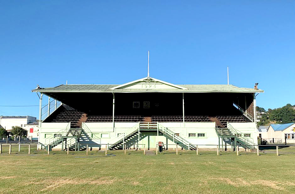
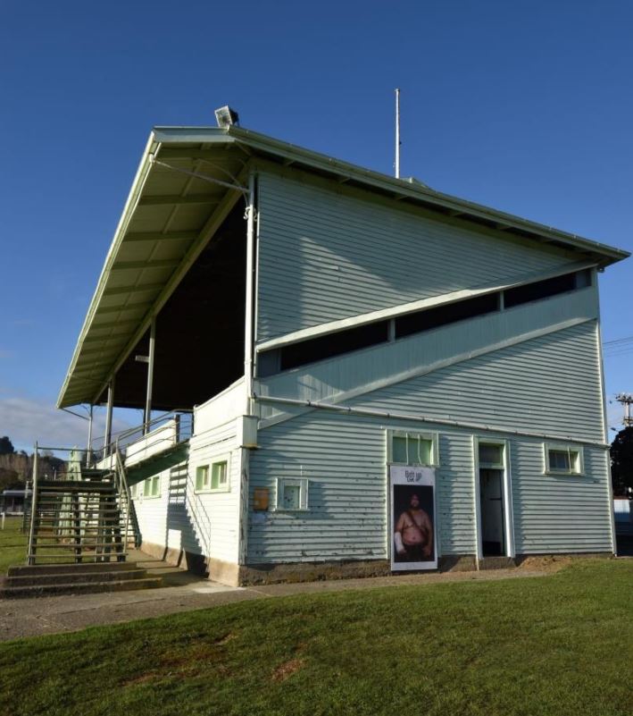
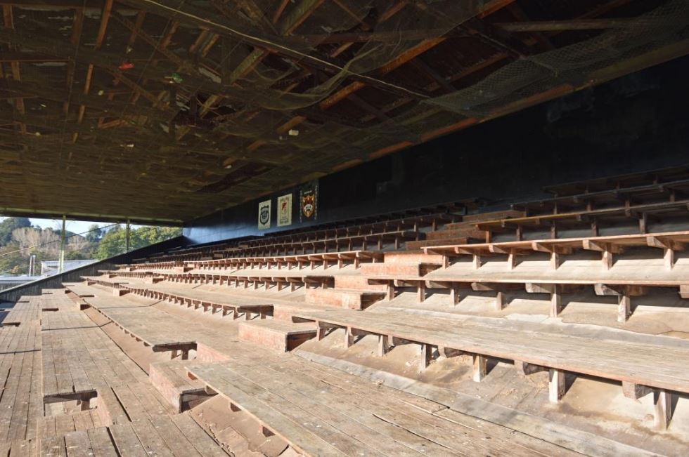
Jorgensen’s subsequent plan of 15 December 1923 shows a two-storied timber grandstand with 10 tiers of bench seating accessed via a central set of stairs and landing, with single set of stairs towards both ends. The ground floor had a large central refreshment room with cooking facilities and a ladies’ and men’s cloak room at either end. Access to the ground floor was via a set of doors under the central stairs, with separate entrances into the two cloak rooms and two doors to the rear of the grandstand into the refreshment room. The building’s structural system involved reinforced concrete columns. Tenders were called in mid-December 1923, and the successful tenderer was local builder Henry Hesketh, with the lowest price of £1973.
Construction had begun by late January 1924, by which time the wider ground improvements were well underway. A ‘big working bee’ had undertaken initial preparation work at the Oval Domain in early 1923 and contractors Messrs MacKenzie and Snow were subsequently awarded the tender to excavate and level the grounds which would have two playing fields, a hockey ground and seven tennis courts when completed. The ground improvements and grandstand were funded by way of a £4000 loan authorised under legislation and approved by a poll of Taihape ratepayers. The grandstand was erected by November 1924 though some of the rooms underneath were still being fitted out. There are references to the room at the south end being ‘converted into a ladies’ rest room’ in December 1924 and a fence was also added around the perimeter of the grandstand. In total, the grandstand cost £2018 to build (including the ladies’ rest room) and had a seating capacity of 800. In 1925 sanitary facilities (shower room, toilet and urinal) were installed in the men’s cloak room. The new grandstand appears to have had an impact on other organisations as in 1926 the Hamilton Rugby Union inspected the grandstand and were ‘so much impressed’ that they requested the original plans. Similarly, the Dannevirke Borough Council asked for ‘the particulars’ of the grandstand in 1928.
Use of the Grandstand
-Taihape and Districts A.&P. Show
The inaugural Rangitīkei Agricultural and Pastoral Association show was held at the Oval Domain in 1912 and the association was the first ‘organised body in the district to have use of the new recreation ground and grandstand’, during their fourteenth annual show on 14-15 January 1925. An account of the show’s opening day noted that the new grandstand provided a ‘long-felt want’ and was well utilised in the afternoon. The association continues to hold their annual show at Taihape Memorial Park (formerly the Oval Domain). It remains a landmark event in the local calendar, and has incorporated the equally popular Gumboot Day since 2020.
- Rugby
As with many rural towns across New Zealand, rugby is ‘big in Taihape’ and the grandstand’s most enduring and significant association is with rugby. Rugby teams have utilised the ground floor facilities and spectators have filled the stands above for close to 100 years. It appears that the relationship between the Taihape Rugby Union and Taihape Borough Council was not always ‘smooth sailing’ though in the initial years after the grandstand’s construction. For example, in 1930 there was a much-publicised dispute about the percentage of takings that the Taihape Rugby Union and other bodies using the grandstand would be given.
The grandstand is most closely connected with the Taihape Rugby and Sports Club and Utiku & Old Boys Rugby Football Club, which both have their origins in the early years of Taihape rugby. The Taihape Rugby and Sports Club (previously known as the Taihape Rugby Club) was formed in 1999 when the Huia Rugby and Sports Club and Taihape Pirates Rugby Club amalgamated and their clubrooms are nearby on Kuku Street. Huia was formed in 1897 in Moawhango (though rugby had been played there even earlier) and was principally a Māori rugby club. The original organisers were Hiraka Te Rongo, Hakoha Te Ahunga and Pine Tuakau and the first captain was Punch Pine. Taihape Pirates Rugby Club was founded in 1909 and traditionally included workers from around the town, including the railways ‘fraternity’. Utiku & Old Boys is also a merger club and has a mostly rural membership – it was formed in 1949 when the Utiku Rugby Club (1922) combined with the Old Boys Club (1921) and erected club rooms just to the south-east of the grandstand.
The grandstand has born witness to countless matches over the years, including one memorable game in 1936 when Huia was about to commence play against Mangaweka. One of the Huia players was missing their jersey and as the team was about to file out on the field, an aeroplane was heard overhead, and it swooped down and dropped a brown paper parcel in front of the grandstand. There were roars of laughter from the spectators as a ‘ubiquitous small boy retrieved and unwrapped the missing jersey’!
-Other Uses
The grandstand has also been used by many other groups and clubs over the years, and for a range of different activities from sports matches and event days to civic functions, Christmas celebrations and even political meetings and events. On 4 April 1930 for example, the Right Hon. J.G. Coates and Mrs Coates visited Taihape and were entertained at a garden party at the Oval Domain organised by the Reform League. The ‘grandstand, enclosure and basement were tastefully decorated for the occasion and the tables were attractively set out’. Other groups paid to specifically use the ground floor space of the grandstand for storage and other activities such as band practice. In 1940 during the Second World War, troops on leave in Taihape were granted use of the Town Hall and rooms underneath the grandstand for entertainment purposes on Saturday and Sunday nights.
The grandstand is still used today for purposes other than rugby matches and the annual A. & P. show. The local Fire Brigade use the staircases for training for example and Mōkai Pātea Services also use the grandstand and other facilities at the park when running iwi-led projects and initiatives.
Subsequent Changes to the Grandstand (1930s-2019)
There have been several changes to the grandstand since it was constructed, most of which relate to the ground floor interior layout. A ticket office was installed towards the north-western end of the grandstand and in the mid-1930s a door was added in the north-western elevation to provide direct access to the office. In 1945 the north-western end of the grandstand was enclosed to provide shelter and safety and in 1950 a St John’s Ambulance room was added to the south-eastern end by partitioning off part of the ladies’ cloak room and adding a separate external door.
The grandstand was also incorporated into a wider commemorative landscape in the early 1950s with the creation of the Taihape and Districts War Memorial Park (‘Memorial Park’) through an extension of the Oval Domain. A memorial garden and memorial plaque were added inside the main entrance gate to the park (‘memorial gate’) on Kokako Street in 1953, just to the north-west of the grandstand, and it’s presumed that the arched iron ‘Memorial Park’ sign was added to the top of memorial gate at this time.
The interior layout of the grandstand was reconfigured around 1980 to provide multiple changing rooms along the north-eastern elevation and showers on the south-western side, and a mezzanine floor was added at the south-eastern end. On 16 August 1980 the grandstand was in use during a football match when a sudden and strong gust of wind lifted the roof and the grandstand was consequently evacuated and closed off. Repairs and strengthening work were undertaken and it’s understood that the roof was subsequently replaced. The original chimney associated with the former public refreshment room was recently (post-2017) removed from the south-western elevation and in 2019 three local rugby club murals were affixed along the back wall at the top of the grandstand – they were painted by Year 9 art students at Taihape Area School, under the supervision of teacher Timoti Pekamu depicting the Taihape Rugby Club, Utiku & Old Boys Rugby and Football Club (1949) and Huia Rugby Club (1897).
A Community Icon in Need of Restoration
The condition of the grandstand and its future viability have been the subject of discussion within the Taihape community for several years. The poor condition of the ground floor amenities was of particular concern (especially for the rugby union), as were the power connectivity issues, and structural issues had been identified. In February 2020 the Rangitīkei District Council voted in favour of building a new amenities block at the southern end of the rugby field, giving rise to community concerns that the grandstand would be left ‘to flounder’.
In July 2020, the Taihape Heritage Trust presented a 648-signature petition (48% of the town’s population over 15 years of age) to the Council which requested that they retain and upgrade the amenities under the grandstand. The Council subsequently delayed their decision to proceed with a new amenities block and undertook further community consultation and specialist investigations. After considering the further information, the Council voted to proceed with the new $2.1 million amenities block in December 2020, and ground works began in March 2022. The Ngā Awa Block is due for completion at the southern end of the rugby field in January 2023.
Meanwhile, the Council has set aside $1,000,000 in their 2021-2031 Long Term Plan for the strengthening of the grandstand which was identified in July 2021 as having a New Building Standard (NBS) rating of 17% when in use. Community consultation on the Long Term Plan revealed ‘strong support’ for the grandstand. The Council is currently awaiting a report (due spring 2022) that will detail the full strengthening costs for the grandstand and is anticipating the need for additional fundraising to ensure the long-term preservation of one of Taihape’s key heritage buildings.