

Both iwi history and archaeological evidence show Māori occupation in the Ōtākou / Otago region since the twelfth century. Tradition tells us the atua Tū-te-rākiwhanoa discovered the wrecked celestial waka of Aoraki (Te Waka o Aoraki / South Island) and carved out places for people to live, including Muaupoko / Otago Peninsula. In another telling, the atua Kahukura was believed to have shaped the Otago coastline, eaten out the harbour and thrown up the earth either side thus forming the western shore and the peninsula. The harbour was shallow before Europeans arrived and provided abundant resources for hapū. Prior to and at the onset of European arrival there were numerous settlements about the coastal margins of the Peninsula. On 31 July 1844 the Otago Purchase, negotiated for Pākehā by Frederick Tuckett, was signed at Kōpūtai / Port Chalmers. This agreement followed many weeks of negotiation which left the majority of Muaupoko / Otago Peninsula in European hands – this outcome was contrary to the initial aims of the Māori negotiators who had ‘indicated their wish to retain all the eastern side [of the harbour]’. Section surveys for part of the future Glenfalloch property – particularly Section 29, Upper Harbour East, where the homestead now sits – exist from as early as 1845. However, the first ownership records of the land date to 1863, when John Nichol sold the land to Thomas Reynolds, who later transferred the property to Colin Macandrew. In 1876, the property was sold to George G. Russell.
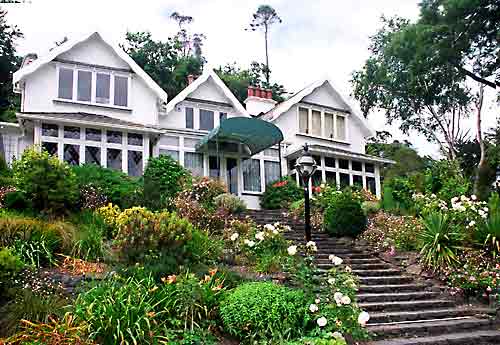
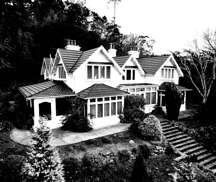
The origins of the homestead are complicated. A building certainly existed on the site by the end of the 1870s or early-1880s, as evidenced by a photograph showing the old stables and byre on the left-hand side of the photograph and a building on the prominent hillock on which the homestead now sits on the right-hand side. The homestead shown in this photograph is of a significantly lesser size and complexity of roof layout to how the homestead looks today. By 1885, when artist Mathew Hodgkins sketched multiple views of the site, the homestead had assumed the approximate proportions and roof layout that can be seen today. There are two likelihoods – that before 1885 the original homestead building was demolished to make way for the current building; or that the original building underwent a substantial alteration, with multiple additions and remodelling of its roof and upper storey, making the current homestead building. The current Glenfalloch homestead was ‘constructed of New Zealand Kauri and Baltic Pine and when built comprised 5 dormer bedrooms, a dressing room, bathroom, boxroom and maids' quarters upstairs, and on the ground floor a sitting room, smoking room, dining room, breakfast room, morning room, wine cellar, pantry, kitchen and another bathroom.’ The two reception rooms of the homestead are said to possess carvings by the prominent carver Lewis Godfrey; secondary historic sources say that Godfrey was ‘brought out from England to work on Larnach’s Castle, constructed 1871-4.’
In 1917, the homestead was sold to Philip Barling. Under Barling, a major upgrade of the homestead’s fenestration occurred, using the talents of the architectural firm of Edmund Anscombe, H McDowell Smith and Associates, giving the building’s façade a distinctly Arts and Crafts appearance. Following Philip’s death in 1956, the grounds of Glenfalloch were opened to the public, and the old stables and coach house were converted into Swiss Chalet tearooms. In 1969, the buildings and grounds were taken up by the Otago Peninsula Trust, in whose ownership the property remains. The building is now partly used as offices by the Otago Peninsula Trust.
List Entry Information
Status
Listed
List Entry Status
Historic Place Category 2
Access
Private/No Public Access
List Number
4716
Date Entered
25th September 1986
Date of Effect
25th September 1986
City/District Council
Dunedin City
Region
Otago Region
Legal description
Pt Lot 2 DP 2679 Upper Harbour East SD
Status
Listed
List Entry Status
Historic Place Category 2
Access
Private/No Public Access
List Number
4716
Date Entered
25th September 1986
Date of Effect
25th September 1986
City/District Council
Dunedin City
Region
Otago Region
Legal description
Pt Lot 2 DP 2679 Upper Harbour East SD
Construction Professional
Name
Edmund Anscombe, H McDowell Smith and Associates
Type
Architectural Partnership
Biography
Name
Lewis Godrey
Type
Carver
Biography
Construction Details
Type
Modification
Description
Alterations to the building
Period
1880s
Start Year
1917
Finish Year
1921
Type
Modification
Description
Alterations to the homestead’s façade
Construction Professional
Name
Edmund Anscombe, H McDowell Smith and Associates
Type
Architectural Partnership
Biography
Name
Lewis Godrey
Type
Carver
Biography
Construction Details
Type
Modification
Description
Alterations to the building
Period
1880s
Start Year
1917
Finish Year
1921
Type
Modification
Description
Alterations to the homestead’s façade
Historical and Associated Iwi / Hapū / Whānau
Completion Date
1st July 2025
Report Written By
Andrew Winter
Other Information
This place was identified as significant under previous legislation with different information requirements. It remains significant under the current legislation. A fully referenced copy of the Upgrade Report is available upon request from the Otago/Southland Area Office of Heritage New Zealand Pouhere Taonga. Disclaimer Please note that entry on the New Zealand Heritage List/Rārangi Kōrero identifies only the heritage values of the property concerned, and should not be construed as advice on the state of the property, or as a comment of its soundness or safety, including in regard to earthquake risk, safety in the event of fire, or insanitary conditions. Archaeological sites are protected by the Heritage New Zealand Pouhere Taonga Act 2014, regardless of whether they are entered on the New Zealand Heritage List/Rārangi Kōrero or not. Archaeological sites include ‘places associated with pre-1900 human activity, where there may be evidence relating to the history of New Zealand’. This List entry report should not be read as a statement on whether or not the archaeological provisions of the Act apply to the property(s) concerned. Please contact your local Heritage New Zealand office for archaeological advice.
Historical and Associated Iwi / Hapū / Whānau
Completion Date
1st July 2025
Report Written By
Andrew Winter
Other Information
This place was identified as significant under previous legislation with different information requirements. It remains significant under the current legislation. A fully referenced copy of the Upgrade Report is available upon request from the Otago/Southland Area Office of Heritage New Zealand Pouhere Taonga. Disclaimer Please note that entry on the New Zealand Heritage List/Rārangi Kōrero identifies only the heritage values of the property concerned, and should not be construed as advice on the state of the property, or as a comment of its soundness or safety, including in regard to earthquake risk, safety in the event of fire, or insanitary conditions. Archaeological sites are protected by the Heritage New Zealand Pouhere Taonga Act 2014, regardless of whether they are entered on the New Zealand Heritage List/Rārangi Kōrero or not. Archaeological sites include ‘places associated with pre-1900 human activity, where there may be evidence relating to the history of New Zealand’. This List entry report should not be read as a statement on whether or not the archaeological provisions of the Act apply to the property(s) concerned. Please contact your local Heritage New Zealand office for archaeological advice.
Current Usages
Uses: Trade
Specific Usage: Office building/Offices
Former Usages
General Usage: Accommodation
Specific Usage: House
Current Usages
Uses: Trade
Specific Usage: Office building/Offices
Former Usages
General Usage: Accommodation
Specific Usage: House
Location
Sign up to hear more
Get the latest heritage news, features and events delivered
straight to your inbox.
