

The land on which the site is located was surveyed as a Native Reserve in 1868, named Korotuaheka. In 1916 the Māori Land Board sanctioned leasing the reserve to a Pākehā farmer, and a few years later allowed the sale of the reserve, though the urupā was reserved. In 1879 a number of families, led by Te Maiharoa, were evicted from their settlement at Ōmarama where they had been protesting the land sales. They established a settlement at Korotuaheka and built a church/meeting house and established a wānanga on the reserve. Te Maiharoa died at Korotuaheka and was buried there in 1885 or 1886.
The name Waitaki (the waterway of tears) is often referred to in whaikōrero as ‘representing the tears of Aoraki which spill into Lake Pukaki and eventually make their way south along the river to the coast. The whakataukī ‘Ko Waitaki te awa, ka roimata na Aoraki I riringi’ captures this significance – ‘Waitaki is the river, the tears spilled by Aoraki’
This site attracted amateur archaeologists’ attention in 1926, when what became identified as the No. 1 terrace was ploughed, apparently for the first time, exposing moa bones and middens. H.S McCully and A.G. Hornsey of Timaru worked here and on No. 2 terrace. Teviotdale followed their work in 1931, and again in 1936-37, although it has not been possible to identify precisely the area he excavated – his article in the Journal of Polynesian Society provides a detailed description of the site at this time. Hardwicke Knight and Peter Gathercole visited the site in the 1960s, hoping to make contact with knowledgeable locals and examine collections in private hands, to record the occupation area, and to carry out trial excavations. They were successful in determining an extent for the occupation site.
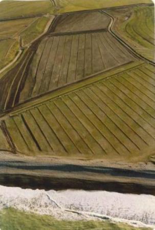
The site is situated about one and a half kilometres south of the Waitaki River Mouth. The site extends over an area of approximately 50 hectares. It is believed by Athol Anderson to possibly be the largest moa hunting site on the east coast of the South Island. Anderson notes that up to 90,000 moa could have been processed here. In 2002 archaeologists Shar Briden and Matthew Schmidt were shown an intact area of the site by the landowner. In places the site is eroding and has also been ploughed. Ploughing and fossicking have destroyed the surface indications of stone pavings and huts. Surface evidence of occupation is scattered over the three river terraces. On the northern side, the occupation evidence finishes at an old water course, with the western and southern margins also clear. On the eastern (seaward) side, the site is being eroded. The Waitaki River Mouth site has been interpreted ‘as an intermittently occupied moa-hunting camp and as a transit camp for summer inland expeditions into the Waitaki catchment for birds and silcrete.’
Ngāi Tahu recognise Korotuaheka as one of the oldest recorded settlement sites in the island. In 2018, the Waitaki River Mouth Moa-hunting Site is in private ownership.
List Entry Information
Status
Listed
List Entry Status
Historic Place Category 2
Access
Private/No Public Access
List Number
5690
Date Entered
11th March 1985
Date of Effect
11th March 1985
City/District Council
Waitaki District
Region
Otago Region
Extent of List Entry
Extent includes part of the land described as Lot 2 DP 302602 (RT 10157), Otago Land District, and the archaeological site known as Korotuaheka/Waitaki River Mouth Moa Butchery Site thereon. Refer to the extent map tabled at the Rārangi Kōrero Committee meeting on 8 March 2018.
Legal description
Lot 2 DP 302602 (RT 10157), Otago Land District
Construction Details
Type
Original Construction
Description
Occupation
Period
13th Century
Start Year
1926
Type
Modification
Description
First ploughing of the site
Type
Other
Description
Teviotdale excavation
Start Year
1936
Finish Year
1937
Type
Other
Description
Teviotdale excavation
Start Year
1954
Type
Modification
Description
Site ploughed
Start Year
1961
Finish Year
1963
Type
Other
Description
Gathercole excavation
Historical and Associated Iwi / Hapū / Whānau
Public NZAA Number
J41/56
Completion Date
29th January 2018
Report Written By
Heather Bauchop
Information Sources
New Zealand Archaeological Association (NZAA)
New Zealand Archaeological Association
Journal of the Polynesian Society
Journal of the Polynesian Society
Te Ara - The Encyclopedia of New Zealand
www.TeAra.govt.nz
Lore and History of the South Island Maori
A. Taylor, Lore and History of the South Island Maori, Bascands Ltd, Christchurch
Other Information
This place was identified as significant under previous legislation with different information requirements. It remains significant under the current legislation. There is opportunity under our legislation and policies to add to this information. Further information about this place may be available from the Otago/Southland Office of Heritage New Zealand Pouhere Taonga. Please note that entry on the New Zealand Heritage List/Rarangi Korero identifies only the heritage values of the property concerned, and should not be construed as advice on the state of the property, or as a comment of its soundness or safety, including in regard to earthquake risk, safety in the event of fire, or insanitary conditions. A fully referenced upgrade report is available on request from the Otago/Southland Area Office of Heritage New Zealand
Former Usages
General Usage: Ruin
Specific Usage: Misc Archaeological
Themes
Of Significance to Maori
Former Usages
General Usage: Ruin
Specific Usage: Misc Archaeological
Themes
Of Significance to Maori
Location
Sign up to hear more
Get the latest heritage news, features and events delivered
straight to your inbox.
