

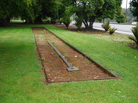
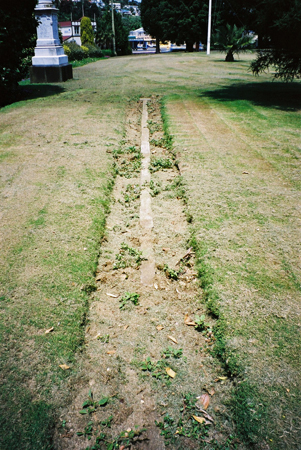
The Standard Chain Mark at Moutoa Gardens was designed and built by the Department of Lands and Survey in 1880 and was fixed in position under the direction of Wanganui's first District Surveyor, John Annabel. It consists of a concrete strip laid down on top of the ground with a concrete block about 30 cm square at either end. Each of the blocks is surmounted by a square brass plate. The distance between the two brass plates is 100 links, or one chain. Surveyors used a standard chain mark to establish the correct length of one chain for their own equipment. The Wanganui Standard Chain Mark could accommodate both old and new forms of the surveyor's equipment, that is Gunter chains and steel tapes respectively. It was first used in 1880 to draw up a plan for the newly formed Wanganui Harbour Board. Standard chain marks were also used as the starting point for the government survey - known as a standard survey - and the first Wanganui standard survey was carried out in June 1883. By 1901 the standard chain mark was no longer in general use, surpassed by changes in technology.
By the early 1970s the Standard Mark had become obscured by grass. In 1972 the Wanganui City Council, at the request of the Whanganui Historical Society, uncovered the mark and placed a plaque alongside it.
Wanganui's Standard Chain Mark is significant as a rare example of surveying technology used in nineteenth century New Zealand. It is associated with a new government policy, following the abolition of the provinces in 1876, to introduce and standardise the surveying profession in New Zealand. At the local level it brought a standardisation of surveying to Wanganui and was a key element in the standard survey of the city. It is also associated with Wanganui's first District Surveyor, John Annabel.
List Entry Information
Status
Listed
List Entry Status
Historic Place Category 1
Access
Able to Visit
List Number
7101
Date Entered
17th December 1993
Date of Effect
17th December 1993
City/District Council
Whanganui District
Region
Horizons (Manawatū-Whanganui) Region
Extent of List Entry
The registration includes the Standard Chain Mark and a curtilage of 5 square metres from the edge of the structure and within Pt Res I Town of Wanganui, Wellington Land District.
Legal description
Pt Res I Town of Wanganui (RT WN21/110), Wellington Land District
Status
Listed
List Entry Status
Historic Place Category 1
Access
Able to Visit
List Number
7101
Date Entered
17th December 1993
Date of Effect
17th December 1993
City/District Council
Whanganui District
Region
Horizons (Manawatū-Whanganui) Region
Extent of List Entry
The registration includes the Standard Chain Mark and a curtilage of 5 square metres from the edge of the structure and within Pt Res I Town of Wanganui, Wellington Land District.
Legal description
Pt Res I Town of Wanganui (RT WN21/110), Wellington Land District
Why is this place significant?
Historic Significance
Historical Significance or Value The following text was prepared as part of an upgrade project and was completed (25 Sept. 2001) The standard Chain Mark, Wanganui was laid down within twelve months of New Zealand's first chain mark in Wellington. It is associated with a significant Government policy following the abolition of the provinces in 1876, to introduce and standardise the surveying profession in New Zealand. This policy, of which standard chain marks were one important aspect, involved the setting up by the Department of Lands and Survey of qualifying examinations for surveyors and the creation of a nation-wide system of mapping that led eventually to the present day cadastral map system.
Physical Significance
The following text was prepared as part of an upgrade project and was completed (25 Sept. 2001) It represents a new standard of accurate measurement and has added interests in that it could accommodate both old and new forms of equipment, that is Gunter Chains and steel tapes respectively. This historic place was registered under the Historic Places Act 1993. The following text is from the original Proposal for Registration considered by the NZHPT Board at the time of registration. ARCHITECTURAL QUALITY: By the turn of the century, at least 18 standard chain marks were recorded as existing in New Zealand. Most of these have been destroyed, however, and the unmodified Wanganui Standard Chain Mark is a rare if not unique survivor. It is fully exposed, in excellent condition and laid down within twelve months of New Zealand's first standard chain mark. It is possible that one in Wellington and part of one in Nelson also survive. TOWNSCAPE/LANDMARK VALUE: Situated at ground level in Wanganui's Moutoa Gardens, the Standard Chain Mark is fully exposed but cannot be considered a landmark.
Why is this place significant?
Historic Significance
Historical Significance or Value The following text was prepared as part of an upgrade project and was completed (25 Sept. 2001) The standard Chain Mark, Wanganui was laid down within twelve months of New Zealand's first chain mark in Wellington. It is associated with a significant Government policy following the abolition of the provinces in 1876, to introduce and standardise the surveying profession in New Zealand. This policy, of which standard chain marks were one important aspect, involved the setting up by the Department of Lands and Survey of qualifying examinations for surveyors and the creation of a nation-wide system of mapping that led eventually to the present day cadastral map system.
Physical Significance
The following text was prepared as part of an upgrade project and was completed (25 Sept. 2001) It represents a new standard of accurate measurement and has added interests in that it could accommodate both old and new forms of equipment, that is Gunter Chains and steel tapes respectively. This historic place was registered under the Historic Places Act 1993. The following text is from the original Proposal for Registration considered by the NZHPT Board at the time of registration. ARCHITECTURAL QUALITY: By the turn of the century, at least 18 standard chain marks were recorded as existing in New Zealand. Most of these have been destroyed, however, and the unmodified Wanganui Standard Chain Mark is a rare if not unique survivor. It is fully exposed, in excellent condition and laid down within twelve months of New Zealand's first standard chain mark. It is possible that one in Wellington and part of one in Nelson also survive. TOWNSCAPE/LANDMARK VALUE: Situated at ground level in Wanganui's Moutoa Gardens, the Standard Chain Mark is fully exposed but cannot be considered a landmark.
Construction Details
Start Year
1880
Type
Original Construction
Description
Laid out
Start Year
1883
Type
Other
Description
Fixed as a survey mark
Start Year
1995
Type
Other
Description
Damaged
Construction Materials
Unreinforced concrete with two brass plaques.
Construction Details
Start Year
1880
Type
Original Construction
Description
Laid out
Start Year
1883
Type
Other
Description
Fixed as a survey mark
Start Year
1995
Type
Other
Description
Damaged
Construction Materials
Unreinforced concrete with two brass plaques.
The following text was prepared as part of an upgrade project and was completed (25 Sept. 2001) Wanganui's Standard Chain Mark introduced new standards of accurate measurement to the Wanganui region and synchronised local measurements with a national standard. It was laid down in Moutoa Gardens within 12 months of New Zealand's first standard chain mark being placed near Wellington's Government Buildings in 1879. Prior to 1879 there had been no uniform method of surveying in the nine provinces of New Zealand and no uniform standard of qualification for surveyors. When the Office of the Surveyor-General was established after the abolition of the provinces in 1876, one of its first tasks was to standardise surveying measurements throughout the country. By 1872 the use of a continuous steel tape was adopted in New Zealand to measure the distance equivalent to 100 links in what was known as a Gunter chain, and this distance was referred to as one 'chain'. A standard chain mark was used to establish the correct length of a chain. As well, the location of such a mark became a starting point for a government survey, known as a 'standard survey' of a particular district. Standard surveys only took place after a settlement had been established for some time and a standard chain mark had been set up in the area. The standard chain mark at Moutoa Gardens was designed and built by the Department of Lands and Survey in 1880 to standards laid down by the Office of the Surveyor-General. In that same year it was used by a surveyor drawing up the plan for the newly formed Wanganui Harbour Board. The first Wanganui standard survey, however, was not carried out until June 1883. This three-year gap between building the chain mark and fixing it into position occurred because of the need to make allowance for ground movement and stabilisation of the mark. By 1901 the standard chain mark in Moutoa Gardens was no longer in use, superseded by a seven-chain mark laid down in Wanganui's Cooks Gardens. However, a second standard survey carried out at the beginning of the twentieth century showed that the Wanganui Standard Chain Mark could still be used as an accurate survey reference. As the use of the standard chain declined, surpassed by new technologies, the Wanganui Standard Chain Mark disappeared from view beneath grass. In 1972 the Whanganui Historical Society requested the city council to uncover it and suitable plaque was placed alongside.
The following text was prepared as part of an upgrade project and was completed (25 Sept. 2001) Wanganui's Standard Chain Mark introduced new standards of accurate measurement to the Wanganui region and synchronised local measurements with a national standard. It was laid down in Moutoa Gardens within 12 months of New Zealand's first standard chain mark being placed near Wellington's Government Buildings in 1879. Prior to 1879 there had been no uniform method of surveying in the nine provinces of New Zealand and no uniform standard of qualification for surveyors. When the Office of the Surveyor-General was established after the abolition of the provinces in 1876, one of its first tasks was to standardise surveying measurements throughout the country. By 1872 the use of a continuous steel tape was adopted in New Zealand to measure the distance equivalent to 100 links in what was known as a Gunter chain, and this distance was referred to as one 'chain'. A standard chain mark was used to establish the correct length of a chain. As well, the location of such a mark became a starting point for a government survey, known as a 'standard survey' of a particular district. Standard surveys only took place after a settlement had been established for some time and a standard chain mark had been set up in the area. The standard chain mark at Moutoa Gardens was designed and built by the Department of Lands and Survey in 1880 to standards laid down by the Office of the Surveyor-General. In that same year it was used by a surveyor drawing up the plan for the newly formed Wanganui Harbour Board. The first Wanganui standard survey, however, was not carried out until June 1883. This three-year gap between building the chain mark and fixing it into position occurred because of the need to make allowance for ground movement and stabilisation of the mark. By 1901 the standard chain mark in Moutoa Gardens was no longer in use, superseded by a seven-chain mark laid down in Wanganui's Cooks Gardens. However, a second standard survey carried out at the beginning of the twentieth century showed that the Wanganui Standard Chain Mark could still be used as an accurate survey reference. As the use of the standard chain declined, surpassed by new technologies, the Wanganui Standard Chain Mark disappeared from view beneath grass. In 1972 the Whanganui Historical Society requested the city council to uncover it and suitable plaque was placed alongside.
The following text was prepared as part of an upgrade project and was completed (25 Sept. 2001) The Standard Chain mark consists of a concrete strip laid down on top of the ground with a concrete block about a foot square at either end. Each of the blocks is surmounted by a square brass plate. The plate at the south end has a small hole into which lead has been inserted and the one at the north end has two holes to which metal hooks would have been attached. The distance between the two brass plates in one chain. The concrete strip lies anti-clockwise of true north-south and bears the inscription 'NZ SURVEYS CHAIN STANDARD 1880 66 FEET'. This historic place was registered under the Historic Places Act 1993. The following text is from the original Proposal for Registration considered by the NZHPT Board at the time of registration. ARCHITECT/ENGINEER/DESIGNER: Designed and built by the Department of Lands and Survey. Fixed into position under Wanganui's first District Surveyor John Annabel.
The following text was prepared as part of an upgrade project and was completed (25 Sept. 2001) The Standard Chain mark consists of a concrete strip laid down on top of the ground with a concrete block about a foot square at either end. Each of the blocks is surmounted by a square brass plate. The plate at the south end has a small hole into which lead has been inserted and the one at the north end has two holes to which metal hooks would have been attached. The distance between the two brass plates in one chain. The concrete strip lies anti-clockwise of true north-south and bears the inscription 'NZ SURVEYS CHAIN STANDARD 1880 66 FEET'. This historic place was registered under the Historic Places Act 1993. The following text is from the original Proposal for Registration considered by the NZHPT Board at the time of registration. ARCHITECT/ENGINEER/DESIGNER: Designed and built by the Department of Lands and Survey. Fixed into position under Wanganui's first District Surveyor John Annabel.
Historical and Associated Iwi / Hapū / Whānau
Completion Date
25th September 2001
Report Written By
Helen McCracken
Information Sources
Plans
Architectural Drawings/Plans
Other Information
This historic place was registered under the Historic Places Act 1980. This report includes text from the original Proposal for Registration considered by the NZHPT Board at the time of registration. Please note that entry on the New Zealand Heritage List/Rarangi Korero identifies only the heritage values of the property concerned, and should not be construed as advice on the state of the property, or as a comment of its soundness or safety, including in regard to earthquake risk, safety in the event of fire, or insanitary conditions.
Historical and Associated Iwi / Hapū / Whānau
Completion Date
25th September 2001
Report Written By
Helen McCracken
Information Sources
Plans
Architectural Drawings/Plans
Other Information
This historic place was registered under the Historic Places Act 1980. This report includes text from the original Proposal for Registration considered by the NZHPT Board at the time of registration. Please note that entry on the New Zealand Heritage List/Rarangi Korero identifies only the heritage values of the property concerned, and should not be construed as advice on the state of the property, or as a comment of its soundness or safety, including in regard to earthquake risk, safety in the event of fire, or insanitary conditions.
Former Usages
General Usage: Exploration
Specific Usage: Chain mark
Former Usages
General Usage: Exploration
Specific Usage: Chain mark
Location
Sign up to hear more
Get the latest heritage news, features and events delivered
straight to your inbox.
