

List Entry Information
Status
Listed
List Entry Status
Historic Place Category 2
Access
Private/No Public Access
List Number
7297
Date Entered
14th December 1995
Date of Effect
14th December 1995
City/District Council
Waimakariri District
Region
Canterbury Region
Extent of List Entry
Extent includes part of the land described as Res 3046 (RT CB28F/775, NZ Gazette 1894, p. 1729), Canterbury Land District and the structure known as Browns Rock Intake and Tunnel thereon. Refer to the extent map tabled at the Rārangi Kōrero meeting on 8 June 2017.
Legal description
Res 3046 (RT CB28F/775, NZ Gazette 1894, p. 1729), Canterbury Land District
Status
Listed
List Entry Status
Historic Place Category 2
Access
Private/No Public Access
List Number
7297
Date Entered
14th December 1995
Date of Effect
14th December 1995
City/District Council
Waimakariri District
Region
Canterbury Region
Extent of List Entry
Extent includes part of the land described as Res 3046 (RT CB28F/775, NZ Gazette 1894, p. 1729), Canterbury Land District and the structure known as Browns Rock Intake and Tunnel thereon. Refer to the extent map tabled at the Rārangi Kōrero meeting on 8 June 2017.
Legal description
Res 3046 (RT CB28F/775, NZ Gazette 1894, p. 1729), Canterbury Land District
Why is this place significant?
Historic Significance
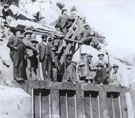
Historical Significance or Value This historic place was registered under the Historic Places Act 1993. The following text is from the original Recommendation for Registration considered by the NZHPT Board at the time of registration. The intake and tunnel represent an engineering solution to the challenge of bringing a reasonably reliable water supply to a drought-prone farming area.
Physical Significance
This historic place was registered under the Historic Places Act 1993. The following text is from the original Recommendation for Registration considered by the NZHPT Board at the time of registration. Archaeological: Construction of the tunnel and intake took place prior to 1900 and therefore the site has archaeological significance. Technological: The tunnel was built in 1896. The engineer of the structure was G.J. Webster who worked for the Selwyn County Council and whose name is recorded on a plaque on the east end of the tunnel. This is an engineering heritage structure that is still in use and serves as an interesting example of an old pastoral water supply intake.
Why is this place Category 1 / Category 2?
Detail Of Assessed Criteria
This historic place was registered under the Historic Places Act 1993. The following text is from the original Recommendation for Registration considered by the NZHPT Board at the time of registration. The following comments are made in relation to the criteria identified under S.23(2) of the Historic Places Act 1993. b) The association of the place with events, persons or ideas of importance in New Zealand history: Improving the carrying capacity of New Zealand pasture land has been the goal of scientists, engineers and farmers for many decades. The rock intake and tunnel are part of an extensive system that is not only still in use 100 years later, but which appears to be capable of further modification and extension. g) The technical accomplishment or value, or design of the place: In 1892, an Act of Parliament constituted the Waimakariri-Ashley Water Supply Board. This enabled the Board to strike a water race based on the government value of the land that the water race serviced. The Brown's Rock Intake is the only survivor of the three original intakes that operated on the Waimakariri and Ashley rivers. The Rockford and Woodstock schemes have been replaced with a high pressure piped scheme. The tunnel is 80 yards long and is large enough for a tractor to drive inside it. It has an arched roof. The intake and tunnel are both constructed of concrete. The original wooden gates were lowered and lifted by screws. An alarm system to the water ranger's house nearby meant that the ranger had to travel about 1 kilometre day and night to lower the gates when there was a rising, or fresh, in the river. Automatic electric gates now do this. There is still an alarm system operating to the ranger's house if levels rise dramatically. The tunnel has had some fittings modified. The original screw gates at the intake were replaced with automatic radial arm gates driven by a 24 volt motor in 1962. Mercury float switches were installed in 1985. Conclusion: The Brown's Rock Intake and Tunnel, Waimakariri River, is recommended for registration as a Category II as a place of historical and cultural heritage significance and value. The intake and tunnel have technological significance and illustrate a nineteenth century engineering approach to providing a reliable pastoral water supply. It is the only survivor of three intakes that operated on the Waimakariri and Ashley rivers.
Why is this place significant?
Historic Significance
Historical Significance or Value This historic place was registered under the Historic Places Act 1993. The following text is from the original Recommendation for Registration considered by the NZHPT Board at the time of registration. The intake and tunnel represent an engineering solution to the challenge of bringing a reasonably reliable water supply to a drought-prone farming area.
Physical Significance
This historic place was registered under the Historic Places Act 1993. The following text is from the original Recommendation for Registration considered by the NZHPT Board at the time of registration. Archaeological: Construction of the tunnel and intake took place prior to 1900 and therefore the site has archaeological significance. Technological: The tunnel was built in 1896. The engineer of the structure was G.J. Webster who worked for the Selwyn County Council and whose name is recorded on a plaque on the east end of the tunnel. This is an engineering heritage structure that is still in use and serves as an interesting example of an old pastoral water supply intake.
Why is this place Category 1 / Category 2?
Detail Of Assessed Criteria
This historic place was registered under the Historic Places Act 1993. The following text is from the original Recommendation for Registration considered by the NZHPT Board at the time of registration. The following comments are made in relation to the criteria identified under S.23(2) of the Historic Places Act 1993. b) The association of the place with events, persons or ideas of importance in New Zealand history: Improving the carrying capacity of New Zealand pasture land has been the goal of scientists, engineers and farmers for many decades. The rock intake and tunnel are part of an extensive system that is not only still in use 100 years later, but which appears to be capable of further modification and extension. g) The technical accomplishment or value, or design of the place: In 1892, an Act of Parliament constituted the Waimakariri-Ashley Water Supply Board. This enabled the Board to strike a water race based on the government value of the land that the water race serviced. The Brown's Rock Intake is the only survivor of the three original intakes that operated on the Waimakariri and Ashley rivers. The Rockford and Woodstock schemes have been replaced with a high pressure piped scheme. The tunnel is 80 yards long and is large enough for a tractor to drive inside it. It has an arched roof. The intake and tunnel are both constructed of concrete. The original wooden gates were lowered and lifted by screws. An alarm system to the water ranger's house nearby meant that the ranger had to travel about 1 kilometre day and night to lower the gates when there was a rising, or fresh, in the river. Automatic electric gates now do this. There is still an alarm system operating to the ranger's house if levels rise dramatically. The tunnel has had some fittings modified. The original screw gates at the intake were replaced with automatic radial arm gates driven by a 24 volt motor in 1962. Mercury float switches were installed in 1985. Conclusion: The Brown's Rock Intake and Tunnel, Waimakariri River, is recommended for registration as a Category II as a place of historical and cultural heritage significance and value. The intake and tunnel have technological significance and illustrate a nineteenth century engineering approach to providing a reliable pastoral water supply. It is the only survivor of three intakes that operated on the Waimakariri and Ashley rivers.
Construction Details
Start Year
1900
startYearCirca
Type
Original Construction
Construction Details
Start Year
1900
startYearCirca
Type
Original Construction
Historical and Associated Iwi / Hapū / Whānau
Other Information
A copy of the original report is available from the NZHPT Southern region office Please note that entry on the New Zealand Heritage List/Rarangi Korero identifies only the heritage values of the property concerned, and should not be construed as advice on the state of the property, or as a comment of its soundness or safety, including in regard to earthquake risk, safety in the event of fire, or insanitary conditions.
Historical and Associated Iwi / Hapū / Whānau
Other Information
A copy of the original report is available from the NZHPT Southern region office Please note that entry on the New Zealand Heritage List/Rarangi Korero identifies only the heritage values of the property concerned, and should not be construed as advice on the state of the property, or as a comment of its soundness or safety, including in regard to earthquake risk, safety in the event of fire, or insanitary conditions.
Former Usages
General Usage: Utilities
Specific Usage: Tunnel/Canal - water
Former Usages
General Usage: Utilities
Specific Usage: Tunnel/Canal - water
Location
Sign up to hear more
Get the latest heritage news, features and events delivered
straight to your inbox.
