

Ngai Tahu korero records that the fiords represent the raised sides of Te Waka o Aoraki (the canoe of Aoraki) which foundered, its occupants turning to stone. Generations later, the southern fiords were carved out of the waka by Tu Te Rakiwhanoa to create a place to live, safe havens on the wild coastline, stocked with fish and birds and plants that would sustain travellers. Maori seasonally occupied the fiords and travelled the rugged coastline for over six hundred years prior to Europeans first venturing to their islands.
Although visited by sealers in the 1790s, whalers were the first Europeans to live in Rakituma / Preservation Inlet when Peter Williams set up one of the country’s earliest shore whaling stations at Cuttle Cove in 1828. Williams’ land deal was also the first documentary land arrangement with Maori in the South Island. The whaling station closed in the mid-1830s. The next people to live in the inlet were the lighthouse keepers at Puysegur Point who manned this isolated station from January 1879 until the keepers were finally withdrawn in 1990.
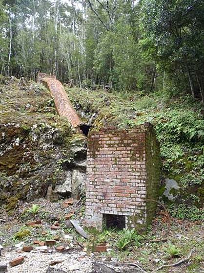
Gold and coal miners and sawmillers followed in the 1890s – carving out an existence in New Zealand’s most isolated goldfields at the small settlements of Cromarty and Te Oneroa. The miners built batteries, pack tracks, adits (horizontal mining tunnels) and tunnels. These remains, including boilers and the Tarawera Smelter, though buried deep in Fiordland’s dense bush, are monuments to the rugged lives of these miners.
In the twentieth century, the lighthouse keepers were the only permanent residents. Rakituma / Preservation Inlet remained a haven for boaties and increasingly an attraction for visitors and tourists on cruises to this wild and scenic area. In 1986, Rakituma / Preservation Inlet’s natural heritage values were recognised when it was inscribed on the World Heritage List as part of Te Wahipounamu – South West New Zealand.
List Entry Information
Status
Listed
List Entry Status
Historic Area
Access
Able to Visit
List Number
9047
Date Entered
3rd September 2015
Date of Effect
2nd October 2015
City/District Council
Southland District
Region
Southland Region
Extent of List Entry
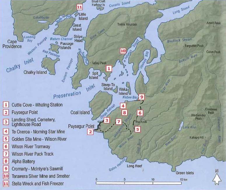
This historic area consists of an area of land and sea that contains a group of inter-related historic places. The area of land that encompasses this group of historic places includes part of the Fiordland National Park and part of the Fiordland Marine Area, Secs 1-5 Blk I, Secs 1-10, 12-15, 20, 22-25, 26 Blk II, Secs 1-8 Blk III, Secs 1-6, 8-11, 13 Blk IV Town of Cromarty, and Sec 37 Town of Te Oneroa (NZ Gazette, 1962 p.724 [NZ Gazette, 1961 p.1299]); Sec 11 Blk II Town of Cromarty (RT SL53/163); Secs 16-17 Blk II Town of Cromarty (RT SL12A/552); Sec 18 Blk II Town of Cromarty (RT SL53/169); Sec 19 Blk II Town of Cromarty (RT SL53/170); Sec 21 Blk II Town of Cromarty (RT SL53/172); Sec 7 Blk IV Town of Cromarty (RT SL53/182); Sec 12 Blk IV Town of Cromarty (RT SL12B/191); Sec 20 Blk IV Preservation SD (RT SL7C/391); Secs 1-36 Town of Te Oneroa (NZ Gazette 1956, pp.1607-8); Legal Road; Foreshore; Seabed; all Southland Land District and the following historic places: Cuttle Cove Sites, Sawmill Sites (Southport), Puysegur Point Lighthouse and Station, Otago Retreat Land Shed and Cemetery, Te Oneroa, Morning Star Mine, Alpha Battery and related sites, Cromarty, Golden Site Mine, McIntyre Sawmill, Wilson River Tramway and Pack Track and associated sites, Tarawera Silver Mine and associated sites, archaeological sites associated with Maori occupation and mining in Rakituma / Preservation Inlet including B45/26, B45/27, B45/29, B45/30, B45/31, B45/32, B45/33, B45/34, B45/35, B45/36, B45/37, B45/38, B45/39, B45/40, B45/41, B45/54, B45/55, B45/56, B45/57, B45/58, B45/78, B46/1, B46/7, B46/14, B46/19, B46/22, B46/23, B46/24, B46/25, B46/27, B46/28, B46/29, B46/30, B46/31, B46/32, B46/33, B46/34, B46/35, B46/36, B46/37, B46/39, B46/40, B46/41, B46/42, B46/43, B46/44, B46/45, B46/46, B46/49, B46/50, B46/56, B46/57, B46/58, B46/59, B46/60, B46/61, B46/62, B46/63, B46/64, B46/65, B46/66, B46/67, B46/68, B46/69, B46/70, B46/71, B46/72, B46/73, B46/74, B46/75, B46/76, B46/77, B46/78, B46/79, B46/80, B46/81, B46/82, B46/83, B46/87, B46/88, B46/89, B46/90, B46/92, B46/93, B46/94, B46/95, B46/96. (Refer to map in Appendix 1 of the registration report for further information). Within the boundary of the historic area there are places that do not contribute to the values of the historic area and are therefore excluded from the group of inter-related historic places that form part of this historic area. These places include Kisbee Lodge, Cromarty. (Refer to maps in Appendix 1 of the List entry report for further information).
Legal description
Secs 1-5 Blk I, Secs 1-10, 12-15, 20, 22-25, 26 Blk II, Secs 1-8 Blk III, Secs 1-6, 8-11, 13 Blk IV Town of Cromarty, and Sec 37 Town of Te Oneroa (NZ Gazette, 1962 p.724 [NZ Gazette, 1961 p.1299]); Sec 11 Blk II Town of Cromarty (RT SL53/163); Secs 16-17 Blk II Town of Cromarty (RT SL12A/552); Sec 18 Blk II Town of Cromarty (RT SL53/169); Sec 19 Blk II Town of Cromarty (RT SL53/170); Sec 21 Blk II Town of Cromarty (RT SL53/172); Sec 7 Blk IV Town of Cromarty (RT SL53/182); Sec 12 Blk IV Town of Cromarty (RT SL12B/191); Sec 20 Blk IV Preservation SD (RT SL7C/391); Secs 1-36 Town of Te Oneroa (NZ Gazette 1956, pp.1607-8); Legal Road; Foreshore; Seabed; all Southland Land District.
Location Description
Associated addresses: 2 Ward Terrace, 12 Ward Terrace, 9 Moray Terrace, 12 Gala Road, 18 Gala Road, Fiordland National Park. The proposed historic area includes areas of land, islands, and sea within Rakituma / Preservation Inlet. It includes the surveyed townships of Cromarty and Te Oneroa and the remains of the industries that were centred in this area.
Status
Listed
List Entry Status
Historic Area
Access
Able to Visit
List Number
9047
Date Entered
3rd September 2015
Date of Effect
2nd October 2015
City/District Council
Southland District
Region
Southland Region
Extent of List Entry
This historic area consists of an area of land and sea that contains a group of inter-related historic places. The area of land that encompasses this group of historic places includes part of the Fiordland National Park and part of the Fiordland Marine Area, Secs 1-5 Blk I, Secs 1-10, 12-15, 20, 22-25, 26 Blk II, Secs 1-8 Blk III, Secs 1-6, 8-11, 13 Blk IV Town of Cromarty, and Sec 37 Town of Te Oneroa (NZ Gazette, 1962 p.724 [NZ Gazette, 1961 p.1299]); Sec 11 Blk II Town of Cromarty (RT SL53/163); Secs 16-17 Blk II Town of Cromarty (RT SL12A/552); Sec 18 Blk II Town of Cromarty (RT SL53/169); Sec 19 Blk II Town of Cromarty (RT SL53/170); Sec 21 Blk II Town of Cromarty (RT SL53/172); Sec 7 Blk IV Town of Cromarty (RT SL53/182); Sec 12 Blk IV Town of Cromarty (RT SL12B/191); Sec 20 Blk IV Preservation SD (RT SL7C/391); Secs 1-36 Town of Te Oneroa (NZ Gazette 1956, pp.1607-8); Legal Road; Foreshore; Seabed; all Southland Land District and the following historic places: Cuttle Cove Sites, Sawmill Sites (Southport), Puysegur Point Lighthouse and Station, Otago Retreat Land Shed and Cemetery, Te Oneroa, Morning Star Mine, Alpha Battery and related sites, Cromarty, Golden Site Mine, McIntyre Sawmill, Wilson River Tramway and Pack Track and associated sites, Tarawera Silver Mine and associated sites, archaeological sites associated with Maori occupation and mining in Rakituma / Preservation Inlet including B45/26, B45/27, B45/29, B45/30, B45/31, B45/32, B45/33, B45/34, B45/35, B45/36, B45/37, B45/38, B45/39, B45/40, B45/41, B45/54, B45/55, B45/56, B45/57, B45/58, B45/78, B46/1, B46/7, B46/14, B46/19, B46/22, B46/23, B46/24, B46/25, B46/27, B46/28, B46/29, B46/30, B46/31, B46/32, B46/33, B46/34, B46/35, B46/36, B46/37, B46/39, B46/40, B46/41, B46/42, B46/43, B46/44, B46/45, B46/46, B46/49, B46/50, B46/56, B46/57, B46/58, B46/59, B46/60, B46/61, B46/62, B46/63, B46/64, B46/65, B46/66, B46/67, B46/68, B46/69, B46/70, B46/71, B46/72, B46/73, B46/74, B46/75, B46/76, B46/77, B46/78, B46/79, B46/80, B46/81, B46/82, B46/83, B46/87, B46/88, B46/89, B46/90, B46/92, B46/93, B46/94, B46/95, B46/96. (Refer to map in Appendix 1 of the registration report for further information). Within the boundary of the historic area there are places that do not contribute to the values of the historic area and are therefore excluded from the group of inter-related historic places that form part of this historic area. These places include Kisbee Lodge, Cromarty. (Refer to maps in Appendix 1 of the List entry report for further information).
Legal description
Secs 1-5 Blk I, Secs 1-10, 12-15, 20, 22-25, 26 Blk II, Secs 1-8 Blk III, Secs 1-6, 8-11, 13 Blk IV Town of Cromarty, and Sec 37 Town of Te Oneroa (NZ Gazette, 1962 p.724 [NZ Gazette, 1961 p.1299]); Sec 11 Blk II Town of Cromarty (RT SL53/163); Secs 16-17 Blk II Town of Cromarty (RT SL12A/552); Sec 18 Blk II Town of Cromarty (RT SL53/169); Sec 19 Blk II Town of Cromarty (RT SL53/170); Sec 21 Blk II Town of Cromarty (RT SL53/172); Sec 7 Blk IV Town of Cromarty (RT SL53/182); Sec 12 Blk IV Town of Cromarty (RT SL12B/191); Sec 20 Blk IV Preservation SD (RT SL7C/391); Secs 1-36 Town of Te Oneroa (NZ Gazette 1956, pp.1607-8); Legal Road; Foreshore; Seabed; all Southland Land District.
Location Description
Associated addresses: 2 Ward Terrace, 12 Ward Terrace, 9 Moray Terrace, 12 Gala Road, 18 Gala Road, Fiordland National Park. The proposed historic area includes areas of land, islands, and sea within Rakituma / Preservation Inlet. It includes the surveyed townships of Cromarty and Te Oneroa and the remains of the industries that were centred in this area.
Why is this place significant?
Cultural Significance
Cultural Significance or Value Rakituma / Preservation Inlet has special cultural significance for Ngai Tahu. Ngai Tahu korero records that the fiords represent the raised sides of Te Waka o Aoraki which foundered, its occupants turning to stone. Generations later, the southern fiords were carved out of the waka by Tu Te Rakiwhanoa to create a place to live, safe havens on the wild coastline, stocked with fish and birds and forests that would sustain travellers. As a place where Maori seasonally occupied the fiords and travelled the rugged coastline for over six hundred years prior to Europeans first venturing to their islands, Rakituma / Preservation Inlet is also a repository of the material culture remaining from that period. The New Zealand Archaeological Association has recorded a large number of Maori sites. Internationally, Rakituma / Preservation Inlet is included in Te Wahipounamu - South West New Zealand World Heritage List site that recognises the value placed on its natural history. Spiritual Significance or Value There is a cemetery at Otago Retreat dating from 1890 to 1926, and at least four isolated burials in the inlet (mainly miners). There is also a probability of Maori burials in the area, though none have been located as yet. In a place where there are few human traces, these graves have a spiritual significance, representing life and death in this isolated place.
Historic Significance
Historical Significance or Value Rakituma / Preservation Inlet has considerable historic significance to both Maori and Europeans. The sites at Rakituma / Preservation Inlet tell stories that are of outstanding significance in New Zealand’s history – early Ngai Tahu korero about the Aoraki waka, the lifeways of early Maori settlement sites, places named and visited by Captain Cook, one of New Zealand’s first on shore whaling sites where the first document relating to land use between Maori and Pakeha was created, and nineteenth century stories about shipping, mining, and sawmilling. The histories are linked by the theme of people exploiting natural resources - be they kai moana, whales, timber or gold. Preservation Inlet was home to communities of people who came to exploit these resources. The prehistoric Maori sites show a long history of living in and visiting Rakituma / Preservation Inlet. From the nineteenth century onwards European whalers, gold miners and sawmillers made Rakituma / Preservation Inlet their home for as long as the returns on their efforts were sufficient. Cromarty, Te Oneroa, Puysegur Point and the isolated settlements of miners working their own claims illustrate the social life of this remote area and the physical remains provide insight into these communities. The insight is all the more poignant because Rakituma / Preservation Inlet is now largely uninhabited and the only visitors are trampers, passing boats and the occasional cruise ship. This isolation provides a sense of life in one of the remotest areas of New Zealand.
Physical Significance
Aesthetic Significance or Value Rakituma / Preservation Inlet has special aesthetic significance as a spectacular remote fiord exposed to wild weather and surrounded by impenetrable bush. The remains of places where people lived and worked give a sense of the isolation and impermanence of human life. The few traces of human activity – occupations sites, gold remains, the lighthouse station – emphasise the power of the natural world, but also the tenacity of those who lived here. The remnants of human activity and habitation give a moving illustration of the impact of people on this outstanding landscape and the frailty of human presence here. Archaeological Significance or Value The area has outstanding potential to provide insight into an early and very significant period of New Zealand’s history and of Maori settlements and ways of life through archaeological methods. The area has outstanding significance because it has some of the earliest / first examples of activities such as whaling and because it has since been relatively undisturbed. Rakituma / Preservation Inlet is scattered with places of archaeological significance. There are archaeological remnants associated with early Maori occupants, of whalers, of gold and coal miners and of the lighthouse keepers. These traces represent working systems of gold and coal mining and of life in this isolated area. The archaeological remains draw together the theme of the use of natural resources and the technologies and systems developed to exploit them. Technological Significance or Value All the mining sites within Rakituma / Preservation Inlet exhibit technologies dating from the later part of the industrial revolution. These technologies are evident in the remaining stamper batteries, steam boilers, smelters and tramway. The Wilsons River tramway demonstrates the use of rail transportation and bush tramways for both gold mining and sawmilling. The Tarawera smelter retains evidence of the smelting technology used in the late nineteenth and early twentieth centuries.
Construction Details
Type
Other
Description
Waitaha occupation
Period
Circa 1500s
Start Year
1829
Type
Other
Description
Cuttle Cove whaling station established
Start Year
1836
Type
Other
Description
Cuttle Cove whaling station stopped operating
Start Year
1879
Type
Original Construction
Description
Puysegur Point Lighthouse first lit
Type
Other
Description
Gold mining and timber milling begins. Most mining/milling stopped by 1904-1910.
Period
1890s
Start Year
1942
Type
Demolished - Fire
Description
Puysegur Point Lighthouse tower burnt down
Start Year
1943
Type
Reconstruction
Description
Puysegur Point Lighthouse rebuilt
Start Year
1989
Type
Other
Description
Puysegur Point Light automated
Construction Materials
Brick, timber, concrete, iron
Ngai Tahu Traditions In Ngai Tahu tradition the fiords of Te Mimi o Tu Te Rakiwhanoa (Fiordland) are the raised sides of Te Waka o Aoraki. The tipua Aoraki, along with his brothers Raraki and Rakiroa, came to visit their step-mother Papatuanuku and became stranded when their waka overturned as a result of Aoraki reciting an incorrect karakia before their return to the heavens. The waka foundered and its passengers were turned to stone: Aoraki and his brothers, Raraki and Rakiroa stand sentinel as the highest peaks of Ka Tiritiri o te Moana (the Southern Alps). Another tipua, Tu Te Rakiwhanoa, carved out the fiords with his ko (digging stick), with one foot on Ka Tu Waewae o Tu (Secretary Island at the entrance of Doubtful Sound) and Mauikatau (Resolution Island at the entrance to Dusky Sound). Later still, the great Maori explorer Tamatea, captain of the waka Takitimu, named the broken land ‘Te Rua o te moko’, after the deep gouges etched into the cliffs that resemble the face of a tattooed chief. Two main ara tawhito (traditional travelling routes) link Fiordland with Te Wai Pounamu (South Island). A sea route linked Piopiotahi (Milford Sound) to Murihiku. The pre-eminent variety of pounamu, Koko-takiwai, was carried by this route. Rakituma, one of the larger inlets of Te Rua o Te Moko that was useful as a mahinga kai and safe harbour for resting, is now known as Preservation Inlet. The terrain of the land while rugged, still had places where pa and mahinga kai were established and utilised. Sea passage needed safe landing places and tauranga waka (landing places) are found up and down the coastline. Islands and coves in Rakituma / Preservation Inlet had many names bestowed by early Maori, a number of which described the resources to be found there. Ngati Mamoe first visited and lived in the fiords with Ngai Tahu following several generations later. Two Ngati Mamoe pa, Matauira (named after the Ngati Mamoe toa Te Mataiura) and Te Pa a te Whara (established during the early warfare between Ngati Mamoe and Ngai Tahu) are testimonials to traditional place-naming practices. Where there were landing places were nohoanga (seasonal living places), fishing grounds and mahinga kai. Notable pa and nohoanga occurred in many areas on the Fiordland coast. Prominent headlands were useful for defence however, Te Rua o te Moko was primarily visited seasonally to harvest the rich resources found in the many fiords. The clarity of the water; the rugged topography; (at times) tempestuous sailing conditions in turbulent seas and the remoteness of the fiords did not deter seasonal visits to harvest and process terrestrial and marine kai. Kekeno (seals) were dispatched by the expedient method of hitting them on the nose several times with a patu (club); kakapo were speared or caught in snares; paua (abalone) and koura (crayfish) were harvested by hand or in poraka (pots) and a wealth of fish varieties from hapuka (groper) to inaka (whitebait) were harvested from the nutrient rich seas of the fiords. These practices occurred for centuries prior to the first visits by Europeans. Rakituma / Preservation Inlet has several pa or nohoanga, including those at Matauira and another at Te Whare Pa. The tupuna knew of the whakapapa, traditional trails and tauranga waka. They knew of the places to gather kai, they knew where the taonga of the Fiords were and they knew how to use the resources. Many locations and stories of Te Rua o te Moko are intentionally undisclosed or vaguely referenced. The korero that embodies the memories and traditions of Waitaha, Ngati Mamoe and Ngai Tahu tupuna are intrinsic to the mauri of Te Mimi o Tu Te Rakiwhanoa as they maintain integral relationships between the current kaitiaki and the whenua and the tupuna. European Explorers Fiordland’s first European visitor was Captain James Cook, a key figure in the history of New Zealand. On his first voyage in 1769 he mapped the coast, while botanists on board recorded the country’s natural history. Cook’s first voyage provided Europe with its first substantial knowledge of the Maori people. The observations of Cook himself, and of others on the Endeavour, are still valuable sources of information about Maori life at the time of first European contact. In 1770, Captain Cook was the first to write about Fiordland. From the Endeavour he described the fiords, drew the first map and assigned the first European names – ‘Dusky Bay’, West Cape and ‘Doubtfull Harbour.’ Three years later, on his way home from the Antarctic, Cook returned. Cook’s expedition superimposed several more place names on the landscape – an historic tracery which recalls Cook’s journey. Aboard the Resolution Cook entered Dusky Sound, anchoring off the eastern tip of Anchor Island. Cook moored alongside Astronomer Point in Ship Cove, where the expedition conducted important scientific experiments to chart the location of New Zealand. On 29 April 1773, the Resolution left to make her way up the West Coast. In 1791, George Vancouver visited Fiordland on a break from charting the Australian coastline. Vancouver had stayed at Dusky Sound with Cook. He decided to revisit Dusky Sound to give his men a rest. His expedition visited many of the coves charted by Cook and filled in some gaps on the charts, Vancouver could see that Maori had been living in the sounds but did not see any of the residents. Maori were seen in the fiords in the late 1790s, when sealers and whalers began settling in the area. Prior to this, there are no recorded meetings between other European explorers and Maori living in Dusky Sound or Rakituma / Preservation Inlet. This however did not mean Maori were not there, or had forgotten about the area, or indeed ceased to consider it as a valuable mahinga kai area. Judge Edmund Halswell’s 1841 sketch map of the South Island created from an unidentified Ngai Tahu source reveals Rakituma / Preservation Inlet was considered a ‘good’ harbour and the area’s seal population noteworthy. Sealing and Whaling Sealers and whalers were the first Europeans to stay in Fiordland for more than a brief stop. In 1792, Captain William Raven sailed the Britannia into Dusky Sound and left New Zealand’s first sealing gang on Anchor Island. These sealers began the seal slaughter in the south. New South Wales labour regulations in 1805 effectively banned sealing south of Banks Peninsula. Despite these rules, by 1820 sealing gangs had nearly exterminated the seal population. In 1809, American whaler Eber Bunker visited this most southern of the fiords. He reported an inlet that was a safe haven for ships on this storm-wracked coast. He called the inlet Port Preservation. Whales also sheltered in the inlet, calving there in season. The whales were not safe for much longer. With the demise of the seals, whales provided new prey. Peter Williams as agent for George Bunn negotiated with the rangatira Te Whakataupuka for the right to establish a whaling station in Rakituma / Preservation Inlet in 1829. He set up the Port Bunn shore whaling station at Cuttle Cove. Cuttle Cove and Te Awaiti (List no. 7333) at Tory Channel which started at around the same time, were the first shore whaling stations in New Zealand. In the early 1830s whaling was New Zealand’s major commercial industry – mainly funded by Sydney merchants. Cuttle Cove provided safe anchorage, fresh water, a good beach and a flat area to build on. Flat land was rare in a region where cliffs rose straight from the sea. Cuttle Cove has surviving archaeological remains relating to whaling. Williams’ land deal was also the first documentary land arrangement with Maori in the South Island. Williams’ 1829 arrangement was for tenure in return for muskets and gunpowder. There is no record of his thoughts regarding the protection he received as an accepted European under the protection of Te Whakataupuka, the principal rangatira of the Murihiku region. He was in the enviable position of being permitted to stay at Port Bunn without interference from any of the Ngai Tahu hapu; competition from other whaling companies or threat from other Maori iwi. Te Whakataupuka received the muskets and gunpowder in 1838 and they would play a vital part in the defeat of Te Rauparaha. The story is still recounted today: ‘Te Whakataupuka called a hui on Ruapuke and set the strategy. He had Tuhawaiki lead a Taua iti to reconnoitre while [he] traded for more arms for a Taua nui that he would lead the next year. Tuhawaiki had great success and the next year Te Whakataupuka led the Taua nui and cleared the enemy out right up to the Marlborough Sounds. He thought of continuing on to Kapiti but decided to return home and do more trading and gather more arms. The next year he lead another Taua nui with the intention of taking the fight to Kapiti but along with others was stricken down with measles at what is now known as Measley Beach. He had his men take him back to Ruapuke where he died.’ Tuhawaiki later drew and confirmed the boundaries of the whaling station agreement for the 1843 Land Sales Commission that investigated the pre-Treaty of Waitangi land sales. In the early 1850s, Rakituma / Preservation Inlet and Dusky Sound were surveyed by the HMS Acheron’s expedition. Fiordland was part of the Crown’s 1853 Murihiku purchase. The boundary extended from Piopiotahi (Milford Sound) east to Kaihiku and Tokata on the east coast – the whole of the land south of a line from Milford Sound to Tokata or Nugget Point (the southern point of the Otakou purchase). Ngai Tahu disputed aspects of this purchase for over 130 years before resolution of their claim in 1995. Exploiting Resources: Gold, Coal and Timber Gold brought the next wave of people to Rakituma / Preservation Inlet. In 1868 surveyor Adam Johnston was sent to lay out a fishing settlement at Kisbee Bay. Johnston found signs of both gold and coal. Johnston was not optimistic about settlement in such an isolated place. He wrote that the inlet would remain a safe retreat for the ‘distressed mariner, or where a man of science can retire for a while and examine into the mysteries of nature; and where the tourist can wander amongst scenes of beauty and grandeur which may be paralleled but hardly excelled.’ Rakituma / Preservation Inlet was a haven for ships en route between Bluff and Australia – on this rough coast, the inlet provided a haven and a landmark, and a perfect place for a lighthouse. The area was surveyed as a lighthouse reserve in 1874 and building work began. On 1 March 1879, Puysegur Point Lighthouse was lit for the first time. Poking around for things to do when he was off duty, lighthouse keeper Philip Payn went prospecting. Payn found both gold and coal on Coal Island at the entrance to the inlet, and was joined by two other prospectors Wilson and Davis. All three men received a government award for discovering a new goldfield. Payn was eventually dismissed from lighthouse duty for refusing to go on watch because he was working his claim. Other hopeful miners heard about the gold and made the long trip to Rakituma / Preservation Inlet. By 1890, there were some 70 miners on Coal Island. Prospectors went looking for gold at other sites in the inlet, finding gold at Cuttle Cove and in the hills behind the south coast of the inlet. Miners settled at the new towns of Cromarty and Te Oneroa. At its peak, Te Oneroa had all the services of a small town. Cromarty, too, had stores and a hotel and a school. The gold rush was brief and hampered by isolation. In the last years of the nineteenth century, sawmilling replaced gold as an income earner – with mills erected at Southport and at Cromarty. The mills operated for a short time. Once the natural beauty and values of Fiordland were legally recognised in 1904, milling stopped. Protecting and Recognising Natural Values: Fiordland National Park People were not the only visitors to Fiordland. In the mid-1880s, in an effort to curb the rabbit plague, stoats, ferrets, and weasels (mustelids) were introduced in Southland. Opponents warned the government about the potentially devastating effects on New Zealand’s birds. The releases went ahead despite these warnings. By 1888, the impact of mustelids was clear. Weka were among the first victims. Mustelids moved beyond Lake Te Anau into Fiordland. Kiwi, kakapo and whio declined rapidly. Fiordland’s flightless birds needed a safe haven. The Government responded to public concerns with nature preserves. In 1891, Resolution Island, in nearby Dusky Sound was given reserve status. Despite the loss of fauna, the wilderness and natural beauty of the Fiords was recognised. In 1904, Fiordland was reserved as a national park, an area of more than 1,200,000 hectares. Fiordland National Park remains New Zealand’s largest national park. Fishing and Tourism Fishing was the next commercial boom in Rakituma / Preservation Inlet, which has provided a fishing ground as well as a haven for commercial fishing boats. Many commercial operators fished the area. The peak catch was 6,000 tons. Blue cod was the main fishery until the end of the 1940s, with the lobster fisheries developing in the 1950s. The marine biodiversity areas were recognised in 2005 when the Fiordland (Te Moana o Atawhenua) Marine Management Act gazetted eight new marine reserves (building on the existing two) between Milford Sound in the north and Rakituma / Preservation Inlet in the south. These were marked by carved pou. Tourists also visited the fiords. Summer cruises from Dunedin, which had begun in 1877, had come to an abrupt halt in 1910 when the tour boat, the ss Waikare, wrecked near Stop Island in Dusky Sound. Regular tours did not resume until well into the twentieth century. A renewal of tourism followed in the wake of commercial fishing. Charter trips out of Doubtful Sound make the journey down the coast to Rakituma / Preservation Inlet. Overseas cruise ships call into the sounds, providing passengers with a view of the remote wonders of Fiordland. World Heritage In 1986 Westland/Tai Poutini, Aoraki/Mt Cook and Fiordland National Parks were included on the World Heritage List for their natural heritage values. In December 1990 the listing for Te Wahipounamu - South West New Zealand World Heritage List site was widened to include Mt Aspiring National Park and all the intervening and adjacent significant natural areas. This listing recognised Fiordland’s outstanding natural values. In 2015, Rakituma / Preservation Inlet remains an awe-inspiring remote wilderness. The traces left of people’s lives show the tenacity of former residents and other signs of human contact provide a glimpse into the area’s special past.
Ngai Tahu Traditions In Ngai Tahu tradition the fiords of Te Mimi o Tu Te Rakiwhanoa (Fiordland) are the raised sides of Te Waka o Aoraki. The tipua Aoraki, along with his brothers Raraki and Rakiroa, came to visit their step-mother Papatuanuku and became stranded when their waka overturned as a result of Aoraki reciting an incorrect karakia before their return to the heavens. The waka foundered and its passengers were turned to stone: Aoraki and his brothers, Raraki and Rakiroa stand sentinel as the highest peaks of Ka Tiritiri o te Moana (the Southern Alps). Another tipua, Tu Te Rakiwhanoa, carved out the fiords with his ko (digging stick), with one foot on Ka Tu Waewae o Tu (Secretary Island at the entrance of Doubtful Sound) and Mauikatau (Resolution Island at the entrance to Dusky Sound). Later still, the great Maori explorer Tamatea, captain of the waka Takitimu, named the broken land ‘Te Rua o te moko’, after the deep gouges etched into the cliffs that resemble the face of a tattooed chief. Two main ara tawhito (traditional travelling routes) link Fiordland with Te Wai Pounamu (South Island). A sea route linked Piopiotahi (Milford Sound) to Murihiku. The pre-eminent variety of pounamu, Koko-takiwai, was carried by this route. Rakituma, one of the larger inlets of Te Rua o Te Moko that was useful as a mahinga kai and safe harbour for resting, is now known as Preservation Inlet. The terrain of the land while rugged, still had places where pa and mahinga kai were established and utilised. Sea passage needed safe landing places and tauranga waka (landing places) are found up and down the coastline. Islands and coves in Rakituma / Preservation Inlet had many names bestowed by early Maori, a number of which described the resources to be found there. Ngati Mamoe first visited and lived in the fiords with Ngai Tahu following several generations later. Two Ngati Mamoe pa, Matauira (named after the Ngati Mamoe toa Te Mataiura) and Te Pa a te Whara (established during the early warfare between Ngati Mamoe and Ngai Tahu) are testimonials to traditional place-naming practices. Where there were landing places were nohoanga (seasonal living places), fishing grounds and mahinga kai. Notable pa and nohoanga occurred in many areas on the Fiordland coast. Prominent headlands were useful for defence however, Te Rua o te Moko was primarily visited seasonally to harvest the rich resources found in the many fiords. The clarity of the water; the rugged topography; (at times) tempestuous sailing conditions in turbulent seas and the remoteness of the fiords did not deter seasonal visits to harvest and process terrestrial and marine kai. Kekeno (seals) were dispatched by the expedient method of hitting them on the nose several times with a patu (club); kakapo were speared or caught in snares; paua (abalone) and koura (crayfish) were harvested by hand or in poraka (pots) and a wealth of fish varieties from hapuka (groper) to inaka (whitebait) were harvested from the nutrient rich seas of the fiords. These practices occurred for centuries prior to the first visits by Europeans. Rakituma / Preservation Inlet has several pa or nohoanga, including those at Matauira and another at Te Whare Pa. The tupuna knew of the whakapapa, traditional trails and tauranga waka. They knew of the places to gather kai, they knew where the taonga of the Fiords were and they knew how to use the resources. Many locations and stories of Te Rua o te Moko are intentionally undisclosed or vaguely referenced. The korero that embodies the memories and traditions of Waitaha, Ngati Mamoe and Ngai Tahu tupuna are intrinsic to the mauri of Te Mimi o Tu Te Rakiwhanoa as they maintain integral relationships between the current kaitiaki and the whenua and the tupuna. European Explorers Fiordland’s first European visitor was Captain James Cook, a key figure in the history of New Zealand. On his first voyage in 1769 he mapped the coast, while botanists on board recorded the country’s natural history. Cook’s first voyage provided Europe with its first substantial knowledge of the Maori people. The observations of Cook himself, and of others on the Endeavour, are still valuable sources of information about Maori life at the time of first European contact. In 1770, Captain Cook was the first to write about Fiordland. From the Endeavour he described the fiords, drew the first map and assigned the first European names – ‘Dusky Bay’, West Cape and ‘Doubtfull Harbour.’ Three years later, on his way home from the Antarctic, Cook returned. Cook’s expedition superimposed several more place names on the landscape – an historic tracery which recalls Cook’s journey. Aboard the Resolution Cook entered Dusky Sound, anchoring off the eastern tip of Anchor Island. Cook moored alongside Astronomer Point in Ship Cove, where the expedition conducted important scientific experiments to chart the location of New Zealand. On 29 April 1773, the Resolution left to make her way up the West Coast. In 1791, George Vancouver visited Fiordland on a break from charting the Australian coastline. Vancouver had stayed at Dusky Sound with Cook. He decided to revisit Dusky Sound to give his men a rest. His expedition visited many of the coves charted by Cook and filled in some gaps on the charts, Vancouver could see that Maori had been living in the sounds but did not see any of the residents. Maori were seen in the fiords in the late 1790s, when sealers and whalers began settling in the area. Prior to this, there are no recorded meetings between other European explorers and Maori living in Dusky Sound or Rakituma / Preservation Inlet. This however did not mean Maori were not there, or had forgotten about the area, or indeed ceased to consider it as a valuable mahinga kai area. Judge Edmund Halswell’s 1841 sketch map of the South Island created from an unidentified Ngai Tahu source reveals Rakituma / Preservation Inlet was considered a ‘good’ harbour and the area’s seal population noteworthy. Sealing and Whaling Sealers and whalers were the first Europeans to stay in Fiordland for more than a brief stop. In 1792, Captain William Raven sailed the Britannia into Dusky Sound and left New Zealand’s first sealing gang on Anchor Island. These sealers began the seal slaughter in the south. New South Wales labour regulations in 1805 effectively banned sealing south of Banks Peninsula. Despite these rules, by 1820 sealing gangs had nearly exterminated the seal population. In 1809, American whaler Eber Bunker visited this most southern of the fiords. He reported an inlet that was a safe haven for ships on this storm-wracked coast. He called the inlet Port Preservation. Whales also sheltered in the inlet, calving there in season. The whales were not safe for much longer. With the demise of the seals, whales provided new prey. Peter Williams as agent for George Bunn negotiated with the rangatira Te Whakataupuka for the right to establish a whaling station in Rakituma / Preservation Inlet in 1829. He set up the Port Bunn shore whaling station at Cuttle Cove. Cuttle Cove and Te Awaiti (List no. 7333) at Tory Channel which started at around the same time, were the first shore whaling stations in New Zealand. In the early 1830s whaling was New Zealand’s major commercial industry – mainly funded by Sydney merchants. Cuttle Cove provided safe anchorage, fresh water, a good beach and a flat area to build on. Flat land was rare in a region where cliffs rose straight from the sea. Cuttle Cove has surviving archaeological remains relating to whaling. Williams’ land deal was also the first documentary land arrangement with Maori in the South Island. Williams’ 1829 arrangement was for tenure in return for muskets and gunpowder. There is no record of his thoughts regarding the protection he received as an accepted European under the protection of Te Whakataupuka, the principal rangatira of the Murihiku region. He was in the enviable position of being permitted to stay at Port Bunn without interference from any of the Ngai Tahu hapu; competition from other whaling companies or threat from other Maori iwi. Te Whakataupuka received the muskets and gunpowder in 1838 and they would play a vital part in the defeat of Te Rauparaha. The story is still recounted today: ‘Te Whakataupuka called a hui on Ruapuke and set the strategy. He had Tuhawaiki lead a Taua iti to reconnoitre while [he] traded for more arms for a Taua nui that he would lead the next year. Tuhawaiki had great success and the next year Te Whakataupuka led the Taua nui and cleared the enemy out right up to the Marlborough Sounds. He thought of continuing on to Kapiti but decided to return home and do more trading and gather more arms. The next year he lead another Taua nui with the intention of taking the fight to Kapiti but along with others was stricken down with measles at what is now known as Measley Beach. He had his men take him back to Ruapuke where he died.’ Tuhawaiki later drew and confirmed the boundaries of the whaling station agreement for the 1843 Land Sales Commission that investigated the pre-Treaty of Waitangi land sales. In the early 1850s, Rakituma / Preservation Inlet and Dusky Sound were surveyed by the HMS Acheron’s expedition. Fiordland was part of the Crown’s 1853 Murihiku purchase. The boundary extended from Piopiotahi (Milford Sound) east to Kaihiku and Tokata on the east coast – the whole of the land south of a line from Milford Sound to Tokata or Nugget Point (the southern point of the Otakou purchase). Ngai Tahu disputed aspects of this purchase for over 130 years before resolution of their claim in 1995. Exploiting Resources: Gold, Coal and Timber Gold brought the next wave of people to Rakituma / Preservation Inlet. In 1868 surveyor Adam Johnston was sent to lay out a fishing settlement at Kisbee Bay. Johnston found signs of both gold and coal. Johnston was not optimistic about settlement in such an isolated place. He wrote that the inlet would remain a safe retreat for the ‘distressed mariner, or where a man of science can retire for a while and examine into the mysteries of nature; and where the tourist can wander amongst scenes of beauty and grandeur which may be paralleled but hardly excelled.’ Rakituma / Preservation Inlet was a haven for ships en route between Bluff and Australia – on this rough coast, the inlet provided a haven and a landmark, and a perfect place for a lighthouse. The area was surveyed as a lighthouse reserve in 1874 and building work began. On 1 March 1879, Puysegur Point Lighthouse was lit for the first time. Poking around for things to do when he was off duty, lighthouse keeper Philip Payn went prospecting. Payn found both gold and coal on Coal Island at the entrance to the inlet, and was joined by two other prospectors Wilson and Davis. All three men received a government award for discovering a new goldfield. Payn was eventually dismissed from lighthouse duty for refusing to go on watch because he was working his claim. Other hopeful miners heard about the gold and made the long trip to Rakituma / Preservation Inlet. By 1890, there were some 70 miners on Coal Island. Prospectors went looking for gold at other sites in the inlet, finding gold at Cuttle Cove and in the hills behind the south coast of the inlet. Miners settled at the new towns of Cromarty and Te Oneroa. At its peak, Te Oneroa had all the services of a small town. Cromarty, too, had stores and a hotel and a school. The gold rush was brief and hampered by isolation. In the last years of the nineteenth century, sawmilling replaced gold as an income earner – with mills erected at Southport and at Cromarty. The mills operated for a short time. Once the natural beauty and values of Fiordland were legally recognised in 1904, milling stopped. Protecting and Recognising Natural Values: Fiordland National Park People were not the only visitors to Fiordland. In the mid-1880s, in an effort to curb the rabbit plague, stoats, ferrets, and weasels (mustelids) were introduced in Southland. Opponents warned the government about the potentially devastating effects on New Zealand’s birds. The releases went ahead despite these warnings. By 1888, the impact of mustelids was clear. Weka were among the first victims. Mustelids moved beyond Lake Te Anau into Fiordland. Kiwi, kakapo and whio declined rapidly. Fiordland’s flightless birds needed a safe haven. The Government responded to public concerns with nature preserves. In 1891, Resolution Island, in nearby Dusky Sound was given reserve status. Despite the loss of fauna, the wilderness and natural beauty of the Fiords was recognised. In 1904, Fiordland was reserved as a national park, an area of more than 1,200,000 hectares. Fiordland National Park remains New Zealand’s largest national park. Fishing and Tourism Fishing was the next commercial boom in Rakituma / Preservation Inlet, which has provided a fishing ground as well as a haven for commercial fishing boats. Many commercial operators fished the area. The peak catch was 6,000 tons. Blue cod was the main fishery until the end of the 1940s, with the lobster fisheries developing in the 1950s. The marine biodiversity areas were recognised in 2005 when the Fiordland (Te Moana o Atawhenua) Marine Management Act gazetted eight new marine reserves (building on the existing two) between Milford Sound in the north and Rakituma / Preservation Inlet in the south. These were marked by carved pou. Tourists also visited the fiords. Summer cruises from Dunedin, which had begun in 1877, had come to an abrupt halt in 1910 when the tour boat, the ss Waikare, wrecked near Stop Island in Dusky Sound. Regular tours did not resume until well into the twentieth century. A renewal of tourism followed in the wake of commercial fishing. Charter trips out of Doubtful Sound make the journey down the coast to Rakituma / Preservation Inlet. Overseas cruise ships call into the sounds, providing passengers with a view of the remote wonders of Fiordland. World Heritage In 1986 Westland/Tai Poutini, Aoraki/Mt Cook and Fiordland National Parks were included on the World Heritage List for their natural heritage values. In December 1990 the listing for Te Wahipounamu - South West New Zealand World Heritage List site was widened to include Mt Aspiring National Park and all the intervening and adjacent significant natural areas. This listing recognised Fiordland’s outstanding natural values. In 2015, Rakituma / Preservation Inlet remains an awe-inspiring remote wilderness. The traces left of people’s lives show the tenacity of former residents and other signs of human contact provide a glimpse into the area’s special past.
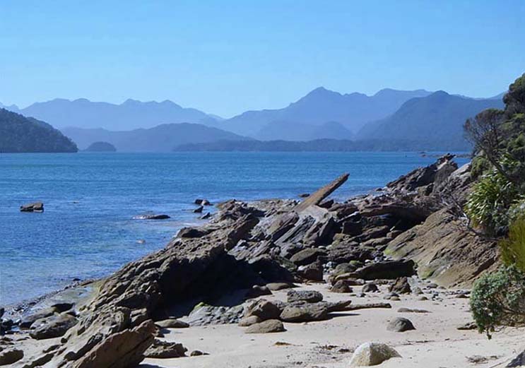
Current Description Rakituma / Preservation Inlet is at the extreme south west of Fiordland. This is the remotest and wildest part of mainland New Zealand. The landscape limited where people could live and what they could do. The few places where people could live are hemmed in by towering cliffs and dense bush. Some visitors fly into the 1980s Kisbee Lodge. Trampers and yachties are regular visitors. As Neville Peat writes ‘human imprints are relatively few and far between.’ However, what imprints there are, are significant, and are related to people’s use of resources – whether gathering kai moana, whaling, sealing or modern fisheries, mineral resources or timber, with the Puseygur Point light guiding those who travelled this rough coast. There are many sites where Maori lived. Whalers, gold miners and saw millers left their own traces. Many of these places are recorded by the New Zealand Archaeological Association. Settlement was close to the coast, the dense bush and steep country discouraging people from living inland. The historic places described below represent the main themes of people’s lives in Rakituma / Preservation Inlet. These sites are all located at the western end of the inlet, where the main settlements were, and where mining took place. Not all places where people lived are described. Maori sites are vulnerable to vandalism or fossicking and so are not described in detail. The Maori sites contribute significantly to the historic area, providing a physical record of where Maori lived. The extent includes the main areas of human activity in Rakituma / Preservation Inlet, and at Southport. The places described in this report represent the main themes of activity – sites where Maori lived, sites visited by early explorers, and commercial activities from whaling, mining, timber milling and lighthouse keeping. There are recorded archaeological sites within the historic area boundary and these are all included in the proposed List entry.
Current Description Rakituma / Preservation Inlet is at the extreme south west of Fiordland. This is the remotest and wildest part of mainland New Zealand. The landscape limited where people could live and what they could do. The few places where people could live are hemmed in by towering cliffs and dense bush. Some visitors fly into the 1980s Kisbee Lodge. Trampers and yachties are regular visitors. As Neville Peat writes ‘human imprints are relatively few and far between.’ However, what imprints there are, are significant, and are related to people’s use of resources – whether gathering kai moana, whaling, sealing or modern fisheries, mineral resources or timber, with the Puseygur Point light guiding those who travelled this rough coast. There are many sites where Maori lived. Whalers, gold miners and saw millers left their own traces. Many of these places are recorded by the New Zealand Archaeological Association. Settlement was close to the coast, the dense bush and steep country discouraging people from living inland. The historic places described below represent the main themes of people’s lives in Rakituma / Preservation Inlet. These sites are all located at the western end of the inlet, where the main settlements were, and where mining took place. Not all places where people lived are described. Maori sites are vulnerable to vandalism or fossicking and so are not described in detail. The Maori sites contribute significantly to the historic area, providing a physical record of where Maori lived. The extent includes the main areas of human activity in Rakituma / Preservation Inlet, and at Southport. The places described in this report represent the main themes of activity – sites where Maori lived, sites visited by early explorers, and commercial activities from whaling, mining, timber milling and lighthouse keeping. There are recorded archaeological sites within the historic area boundary and these are all included in the proposed List entry.
Historical and Associated Iwi / Hapū / Whānau
Iwi: Ngāi Tahu
Public NZAA Number
B45/26
Completion Date
28th July 2015
Report Written By
Heather Bauchop and Huia Pacey
Information Sources
Evison, 1993
Te Wai Pounamu, The Greenstone Island, Wellington, Aoraki Press
Reed, 1951
Reed, A.H. and A.W., Captain Cook in New Zealand, Reed Publishing, 1951.
Hall-Jones, 1968
John Hall-Jones, Early Fiordland, A.H. & A.W. Reed, Wellington, 1968
Other Information
A fully referenced New Zealand Heritage List report is available on request from the Otago Southland Area Office of Heritage New Zealand. Please note that entry on the New Zealand Heritage List/Rarangi Korero identifies only the heritage values of the property concerned, and should not be construed as advice on the state of the property, or as a comment of its soundness or safety, including in regard to earthquake risk, safety in the event of fire, or insanitary conditions.
Current Usages
Uses: Transport
Specific Usage: Footpath/Path/track
Uses: Transport
Specific Usage: Lighthouse
Former Usages
General Usage: Cultural Landscape
Specific Usage: Ancestral landscape
General Usage: Cultural Landscape
Specific Usage: Historic Landscape
General Usage: Cultural Landscape
Specific Usage: Industrial/mining landscape
General Usage: Forestry
Specific Usage: Sawmill
General Usage: Forestry
Specific Usage: Timber extraction - track/ chute/ tramway
General Usage: Maori
Specific Usage: Cave/ rock shelter
General Usage: Maori
Specific Usage: Midden
General Usage: Maori
Specific Usage: Site of mythological event/ traditional or cultural importance
General Usage: Mining
Specific Usage: Battery/Crusher
General Usage: Mining
Specific Usage: Mine - Adit
General Usage: Mining
Specific Usage: Mine Tailings
General Usage: Mining
Specific Usage: Mine Water Race/ Water Race cuttings/tunnels etc
General Usage: Transport
Specific Usage: Lighthouse Station
Themes
Of Significance to Maori
Sign up to hear more
Get the latest heritage news, features and events delivered
straight to your inbox.
