

As indicated by the name, Shepherds Flat was an area associated with the pastoralists of the late 1850s and early 1860s, but it was gold mining that shaped surrounding country from around 1862. Miners worked nearby Vinegar Hill and lived in residence areas held under mining tenure. Among the miners who worked the Shepherds Hut Flat (later called Shepherds Flat) were Thomas and John Morgan, and Thomas Hughes. A 1904 survey plan (SO 7179) for Thomas Morgan and Rees Hughes shows three structures within a post and wire fenced residence area. The cottage probably dates from the nineteenth century and was most likely Thomas Hughes’ residence.
Thomas Hughes was born into a farming family at Carmarthenshire, Wales, in 1833. Employed at an iron works, he came to Victoria, Australia in 1860 and then to Otago in 1861. He formed a business association with John Morgan in 1863. He was a one-time president of the Miners’ Association. His family of five sons and two daughters formed the backbone of the community at Cambrians and the surrounding area. In later years, the property was incorporated into a larger farming block, leased by the Harley family – relations of the Hughes’s. Around the mid-1890s, Hughes’ and Morgan’s mining interests were later combined with mining magnate John Ewing’s under the auspices of the Vinegar Hill Hydraulic Sluicing Company, working the Vinegar Hill area using hydraulic elevating.
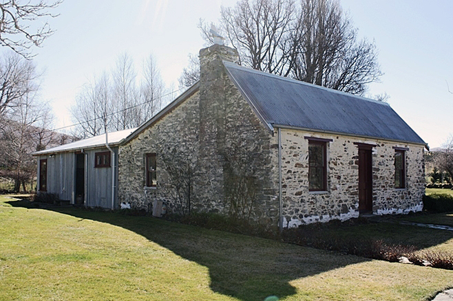
Hughes’ Cottage (Former) is typical of a nineteenth-century gold miner’s residence. It is built of local schist stone, single storey, with a central door flanked by two double-hung sash windows. It is small, probably only two-roomed originally. Hughes’ Cottage was eventually abandoned and became derelict, although a 1993 inspection of the building noted that it was still in good condition. Alterations have been made to the cottage, such as removal of the partition walls to create a largely open-plan space. The original coal range remains, as do the fireplaces. A corrugated iron extension has been added to the rear of the cottage, providing bedrooms and bathrooms. This extension is small in scale, and the timber joinery matches that of the cottage. The original exterior wall of the cottage is exposed, clearly demarcating the original building.
In 2017, the cottage provides holiday accommodation and is known as Lombardy Cottage. Its history reflects the changes in Central Otago in the later years of the twentieth century – from rural backwater to a vibrant economy focused on tourism. It is one of a number of formerly derelict buildings given a new lease of life.
List Entry Information
Status
Listed
List Entry Status
Historic Place Category 2
Access
Private/No Public Access
List Number
9259
Date Entered
25th May 2017
Date of Effect
15th June 2017
City/District Council
Central Otago District
Region
Otago Region
Extent of List Entry
Extent includes part of the land described as Lot 1 DP 300973 (RT 4478), Otago Land District, and the structures known as Hughes’ Cottage (Former) thereon. (Refer to map in Appendix 1 of the List entry report for further information).
Legal description
Lot 1 DP 300973 (RT 4478), Otago Land District
Why is this place significant?
Historic Significance
Historical Significance or Value A mining hamlet, dating from the 1870s, the history of Shepherds Flat tells the story of the spread of mining through the Cambrians/Vinegar Hill/St Bathans area in the 1860s and 1870s. Built close to the mine workings, the cottage shows the way of life of miners living in residence areas while working their claims. Its subsequent abandonment and restoration represents the boom and bust nature of gold mining, and also reflects the revival of the Maniototo as a tourist area with the establishment of the rail trail, leading to a network of accommodation providers and the restoration of gold miner’s cottages.
Physical Significance
Aesthetic Significance or Value Hughes’ Cottage in its setting within a residence area and in the wider landscape has aesthetic significance. Its use of vernacular materials and simple design, the surrounding mature trees and the background of the area’s dramatic mountains, have a strong visual appeal. Archaeological Significance or Value Shepherds Flat is part of a network of sites associated with nineteenth-century gold mining. The cottage sits in what was a nineteenth-century residence area. Its location links to nearby mining remains and is, therefore, part of an archaeological landscape relating to gold mining in the nineteenth and twentieth centuries. The cottage has potential to reveal further information about early mining residences through archaeological methods, particularly buildings archaeology. Architectural Significance or Value The construction materials (mud brick, sod, corrugated iron and stone) and compact scale and layout of the cottage at Shepherds Flat all exemplify the Central Otago vernacular style typical of nineteenth residences in the small gold mining settlements in the Maniototo. It compares with the cottages at the nearby Cambrians Historic Area (List Entry No. 3207).
Why is this place Category 1 / Category 2?
Detail Of Assessed Criteria
(a) The extent to which the place reflects important or representative aspects of New Zealand history Hughes’ Cottage represents the lives of miners in nineteenth century Central Otago and has a strong association with neighbouring Cambrians. The residence areas associated with mining at Shepherd’s Creek and Vinegar Hill were important to this area of Otago. The cottage’s subsequent abandonment and resurrection reflects the history of Central Otago in the twentieth century that has seen economic growth transform the area, particularly associated with the Central Otago Rail Trail. A number of historic properties have been restored that would otherwise probably have remained derelict. (b) The association of the place with events, persons, or ideas of importance in New Zealand history Dating from the nineteenth century, the cottage has an association with Thomas Hughes, a prominent nineteenth-century gold miner in the St Bathans and Cambrians area. Hughes’ Cottage (Former) is associated with gold mining in the nineteenth and early twentieth century in Otago, an event of great significance to New Zealand’s history. (k) The extent to which the place forms part of a wider historical and cultural area Hughes Cottage (Former) is part of the mining hamlet of Shepherds Flat, which dates from the 1870s. Residence areas were dotted along Shepherds Creek and Shepherds Flat Road and mining claims were located further up the valley. Sluicing faces and water races are visible on the hillsides. The residence area in which the cottage is set has a water race along one side of the property.
Construction Details
Start Year
1879
startYearCirca
Finish Year
1889
finishYearCirca
Type
Original Construction
Type
Restoration
Description
Cottage restored
Period
1990s
Construction Materials
Schist, timber, corrugated iron, glass
Construction Details
Start Year
1879
startYearCirca
Finish Year
1889
finishYearCirca
Type
Original Construction
Type
Restoration
Description
Cottage restored
Period
1990s
Construction Materials
Schist, timber, corrugated iron, glass
Exploring Central Otago Māori had settlements in Central Otago, associated with early occupation – there were six settlements at Lake Hāwea (Te Taweha o Hāwea, Mahaea, O tu Purupuru, Turihuka, Te Taumanu o Taki and Pakituhi) and one near Cromwell (Wairere). The moa-rich area was known for camps where moa were butchered and cooked (for example there were large sites in the Hawksburn and Happy Valley areas, as well as the Nevis Valley), and there were quarries used for stone tools in the region of Tiger Hills and Mount Benger. The swampy plains in the Maniototo provided eels and other food resources. Though Māori are known to have joined the gold rushes, little is known about their participation in the gold rush at Cambrians. Cambrians is a small hamlet in the Manuherikia Valley area of Otago. Also known as Dunstan Creek and Welshman’s Gully (after the Welsh miners who settled the area), this was a busy mining settlement in the 1860s. The name derives from Cambria which is the classical name for Wales, being the Latinised form of the Welsh name Cymru. The settlement lies at the foot of Dunstan Range, about six kilometres from St Bathans. From 1858, pastoralists took up land in the Manuherikia Valley. The Lauder Run extended from the tops of the Dunstan Range to the Manuherikia River with the north and south boundaries being the Dunstan and Lauder Creeks. The run changed hands twice before 1860, and three times in the 1860s. Some of the land would be lost to the run when prospectors found gold in the area. Gold In the early 1860s, following the discovery of gold at Gabriel’s Gully, prospectors scrambled through Central Otago seeking gold. Prominent Waikouaiti merchant and businessman John (Johnny) Jones fitted out a prospecting party in December 1861. The party travelled through an isolated area in the upper Manuherikia Valley at the foot of the Dunstan Ranges. Prospector A.G. Reyman wrote to Jones, complaining that the party had been without food for three days and that the runholder was refusing them food because he did not want gold diggers on his run. Reyman complained ‘we had nothing about grass roots for three days previously.’ Despite the hardship, the party of five men explored and found gold in a gully leading down to Dunstan Creek and a deposit of coal nearby. Thomas Swinney was said to be the first person to arrive at Welshman’s Gully. Some of the prospectors stayed on at Dunstan Creek, with the Otago Daily Times reporting in August 1862 that the party had been living at Dunstan Creek for about nine months and had built themselves ‘a comfortable mud hut.’ The paper said that there was room for about 100 diggers, but that miners should be well supplied with ‘sluices and plenty of tools.’ Miners worked by tunnelling and paddocking and then brought in ground sluices to wash out the gold bearing gravels. Shepherds Flat Although gold was discovered in the Cambrians area in the 1860s, it was not until the 1870s that gold miners worked nearby Shepherds Flat. Mining historian John McCraw writes that a party of five was working a claim at Two Mile Creek, and deciding that two men were enough to work the claim, sent three prospecting. On the western side of the ridge between Two Mile and Shepherds Creek, they struck quartz gravel, with payable gold. They sold their interest in the new claim to Thomas Hughes and Thomas Morgan, the two men who had stayed behind to work the claim. Hughes and Morgan cut a water race to the claim in 1874 and soon struck a rich seam. The three who had originally prospected the site, but who had sold their interests to Thomas and Morgan, began a prolonged legal battle to claim a share of the claim. They eventually lost, but a local miner remarked that the battle reminded him of the fighting at Vinegar Hill in Ireland, and the name stuck. In 1879, the Otago Witness reported that miners were building ‘channels’ to facilitate adequate fall for mining. Miners were also working at nearby Vinegar Hill. The Witness reported that a ‘visitor standing on Vinegar Hill with the broad expanse of Shepherds Flat spread before him, a year or two ago, inhabited only by the sheep and the weka, now studded with substantial dwelling houses, must feel convinced that the men who erected these dwellings must see something good and permanent before them in fact we have here an extensive and I believe a very rich goldfield.’ Shepherds Flat (also known as the Vinegar Flat Claim) had strong links with Cambrians. Miners worked deposits in Welshman’s Gully and nearby on Vinegar Flat. Among them were John Morgan and Thomas Hughes who in 1874 established the ‘Vinegar Hill Hydraulic Sluicing Company Limited’. Between 1874 and 1899, they extracted over £20,000 of gold. The scarred landscape shows the workings of hydraulic sluicing and elevating in the area around Cambrians, and water races traverse the hills. The families of the original miners stayed on forming the backbone of the community – their names appear through the years – the Morgans, Williams, Davies, Owens, Hughes, and Harleys. Early Mining at Shepherds Flat Information on Shepherds Flat is difficult to track down. Miners working in this area lived here and at nearby Cambrians. Among the miners who worked the Shepherds Hut Flat (later called Shepherds Flat) were Thomas and John Morgan, and Thomas Hughes. Their gold mining lease application gives Cambrians as their address. They applied for a five-acre lease as ‘Now or Never’, expecting to work the lease with one man for the first six months, and three men after the claim was established. They planned to ground sluice the area at Shepherds Flat. The lease was for a term of ten years. Water was an important resource for miners at Shepherds Hut Flat. In June 1879, the United M and E Co., the Scandinavian Water Race Co., and eleven individual miners applied to take water 25 heads of water from Dunstan Creek to Shepherds Hut Flat to help open out the ‘extensive new workings.’ The applicants were apparently the ‘whole of the holders of claims in the St. Bathans Basin’ of the two races known as the Flushing Races. As with nearby Cambrians, working out who was where and when is a difficult task. Like Cambrians, the land was occupied under mining tenure and is difficult to trace. Hughes’ Cottage A 1904 survey plan (SO 7179) for Thomas Morgan and Rees Hughes shows three structures within a post and wire fenced area on section 123, one of which is the cottage. The cottage sits between the occupation licences of Rees Hughes and Thomas Morgan on sections 99 and 98 respectively, and all indications are that the cottage was the residence of Thomas Hughes, dating to the late nineteenth century. There are a number of other buildings and fenced areas close by. The survey does not note who owns Section 123. In 1907, Thomas Hughes applied to transfer his occupation licence for Section 78 Block I, St Bathans District to Ann J. McCarthy. Another clue to the occupant of this section is Thomas Hughes’ 1911 licence application – which could be for this piece of land (which was unsurveyed at this time). Thomas Hughes applied for a licence to ‘occupy part of the area lying between section 98, block I, St. Bathans district, and the road.’ The yearly licence was granted at a rent of 5 shillings per annum. Survey plan 7179 shows that section 123 is between section 98 and the road, but there may have been other structures on that land. Section 123 was surveyed in 1943, but there was a note that before the property could be freeholded, the road would have to be pegged off. Archives New Zealand holds a file on section 123, held as a renewable lease (farm) by J.D. Morgan, with the dates 1952-1978. Access to this file is restricted. Thomas Hughes was born into a farming family at Carmarthenshire, Wales, in 1833. Employed at an iron-works, he came to Victoria, Australia in 1860 and then to Otago in 1861. He formed a business association with John Morgan in 1863. He was a one-time president of the Miners’ Association. His family of five sons and two daughters formed the backbone of the community at Cambrians and the surrounding area. In later years, the property was incorporated into a larger farming block, leased by the Harley family – who are related to the Hughes family. Around the mid-1890s, Hughes and Morgan’s mining interests later combined with mining magnate John Ewing under the auspices of the Vinegar Hill Hydraulic Sluicing Company, working the Vinegar Hill area using hydraulic elevating. Ewing’s mining empire was near the end of its good fortune, and the deal ended sourly, with Ewing declared bankrupt. New Zealand Historic Places Trust Regional Officer Lois Galer inspected the building in 1993, which, despite being ‘derelict’ for a number of years, was still in good condition. The stone cottage had a small corrugated iron lean-to scullery by the back door. It had been used for storing hay for a number of years and in some places the timber floors were absent. When Galer visited the coal range was still in situ, as was a kauri bench and sink with cupboards below. Subsequent Use The subsequent history of the cottage reflects the changes in Central Otago in the later years of the twentieth century – from rural backwater to a vibrant economy focused on tourism. The Central Otago Rail Trail, the development of boutique accommodation, viticulture and the like has changed the landscape and viability of the region. Derelict buildings have been given a new lease of life – the additions and alterations often reflecting the vernacular architecture of the place – the use of stone and corrugated iron and the modest scale of the buildings. This has been seen in cottages such as Jenkin’s Cottage (List No. 2257, Category 2) in Ophir, in commercial buildings, for example Ophir’s Pitches Store (List No. 7282), in churches (for example the former Catholic Church of the Sacred Heart (List No. 2265, Category 2) at Naseby)), and with industrial buildings (such as the Ida Valley Flour Mill (List No. 2257, Category 2) at Oturehua). Although some have interior alterations and additions, without a viable use these buildings would probably not have survived. In the late 1990s the cottage was sold and restored as a holiday cottage. The Frewens, former publicans of the Vulcan Hotel at St Bathans started the restoration process. They planned to re-lay the floors, build a bathroom into the scullery and shift the kitchen bench into the house. Their plans also included conserving the coal range, fireplaces, stone chimneys, doors, windows and any other existing fittings. A corrugated iron addition was constructed to the rear by subsequent owners Wendy and Graye Shatky, who also began developing the garden. In 2017, the current owners provide boutique accommodation at the cottage which they have named ‘Lombardy Cottage’.
Exploring Central Otago Māori had settlements in Central Otago, associated with early occupation – there were six settlements at Lake Hāwea (Te Taweha o Hāwea, Mahaea, O tu Purupuru, Turihuka, Te Taumanu o Taki and Pakituhi) and one near Cromwell (Wairere). The moa-rich area was known for camps where moa were butchered and cooked (for example there were large sites in the Hawksburn and Happy Valley areas, as well as the Nevis Valley), and there were quarries used for stone tools in the region of Tiger Hills and Mount Benger. The swampy plains in the Maniototo provided eels and other food resources. Though Māori are known to have joined the gold rushes, little is known about their participation in the gold rush at Cambrians. Cambrians is a small hamlet in the Manuherikia Valley area of Otago. Also known as Dunstan Creek and Welshman’s Gully (after the Welsh miners who settled the area), this was a busy mining settlement in the 1860s. The name derives from Cambria which is the classical name for Wales, being the Latinised form of the Welsh name Cymru. The settlement lies at the foot of Dunstan Range, about six kilometres from St Bathans. From 1858, pastoralists took up land in the Manuherikia Valley. The Lauder Run extended from the tops of the Dunstan Range to the Manuherikia River with the north and south boundaries being the Dunstan and Lauder Creeks. The run changed hands twice before 1860, and three times in the 1860s. Some of the land would be lost to the run when prospectors found gold in the area. Gold In the early 1860s, following the discovery of gold at Gabriel’s Gully, prospectors scrambled through Central Otago seeking gold. Prominent Waikouaiti merchant and businessman John (Johnny) Jones fitted out a prospecting party in December 1861. The party travelled through an isolated area in the upper Manuherikia Valley at the foot of the Dunstan Ranges. Prospector A.G. Reyman wrote to Jones, complaining that the party had been without food for three days and that the runholder was refusing them food because he did not want gold diggers on his run. Reyman complained ‘we had nothing about grass roots for three days previously.’ Despite the hardship, the party of five men explored and found gold in a gully leading down to Dunstan Creek and a deposit of coal nearby. Thomas Swinney was said to be the first person to arrive at Welshman’s Gully. Some of the prospectors stayed on at Dunstan Creek, with the Otago Daily Times reporting in August 1862 that the party had been living at Dunstan Creek for about nine months and had built themselves ‘a comfortable mud hut.’ The paper said that there was room for about 100 diggers, but that miners should be well supplied with ‘sluices and plenty of tools.’ Miners worked by tunnelling and paddocking and then brought in ground sluices to wash out the gold bearing gravels. Shepherds Flat Although gold was discovered in the Cambrians area in the 1860s, it was not until the 1870s that gold miners worked nearby Shepherds Flat. Mining historian John McCraw writes that a party of five was working a claim at Two Mile Creek, and deciding that two men were enough to work the claim, sent three prospecting. On the western side of the ridge between Two Mile and Shepherds Creek, they struck quartz gravel, with payable gold. They sold their interest in the new claim to Thomas Hughes and Thomas Morgan, the two men who had stayed behind to work the claim. Hughes and Morgan cut a water race to the claim in 1874 and soon struck a rich seam. The three who had originally prospected the site, but who had sold their interests to Thomas and Morgan, began a prolonged legal battle to claim a share of the claim. They eventually lost, but a local miner remarked that the battle reminded him of the fighting at Vinegar Hill in Ireland, and the name stuck. In 1879, the Otago Witness reported that miners were building ‘channels’ to facilitate adequate fall for mining. Miners were also working at nearby Vinegar Hill. The Witness reported that a ‘visitor standing on Vinegar Hill with the broad expanse of Shepherds Flat spread before him, a year or two ago, inhabited only by the sheep and the weka, now studded with substantial dwelling houses, must feel convinced that the men who erected these dwellings must see something good and permanent before them in fact we have here an extensive and I believe a very rich goldfield.’ Shepherds Flat (also known as the Vinegar Flat Claim) had strong links with Cambrians. Miners worked deposits in Welshman’s Gully and nearby on Vinegar Flat. Among them were John Morgan and Thomas Hughes who in 1874 established the ‘Vinegar Hill Hydraulic Sluicing Company Limited’. Between 1874 and 1899, they extracted over £20,000 of gold. The scarred landscape shows the workings of hydraulic sluicing and elevating in the area around Cambrians, and water races traverse the hills. The families of the original miners stayed on forming the backbone of the community – their names appear through the years – the Morgans, Williams, Davies, Owens, Hughes, and Harleys. Early Mining at Shepherds Flat Information on Shepherds Flat is difficult to track down. Miners working in this area lived here and at nearby Cambrians. Among the miners who worked the Shepherds Hut Flat (later called Shepherds Flat) were Thomas and John Morgan, and Thomas Hughes. Their gold mining lease application gives Cambrians as their address. They applied for a five-acre lease as ‘Now or Never’, expecting to work the lease with one man for the first six months, and three men after the claim was established. They planned to ground sluice the area at Shepherds Flat. The lease was for a term of ten years. Water was an important resource for miners at Shepherds Hut Flat. In June 1879, the United M and E Co., the Scandinavian Water Race Co., and eleven individual miners applied to take water 25 heads of water from Dunstan Creek to Shepherds Hut Flat to help open out the ‘extensive new workings.’ The applicants were apparently the ‘whole of the holders of claims in the St. Bathans Basin’ of the two races known as the Flushing Races. As with nearby Cambrians, working out who was where and when is a difficult task. Like Cambrians, the land was occupied under mining tenure and is difficult to trace. Hughes’ Cottage A 1904 survey plan (SO 7179) for Thomas Morgan and Rees Hughes shows three structures within a post and wire fenced area on section 123, one of which is the cottage. The cottage sits between the occupation licences of Rees Hughes and Thomas Morgan on sections 99 and 98 respectively, and all indications are that the cottage was the residence of Thomas Hughes, dating to the late nineteenth century. There are a number of other buildings and fenced areas close by. The survey does not note who owns Section 123. In 1907, Thomas Hughes applied to transfer his occupation licence for Section 78 Block I, St Bathans District to Ann J. McCarthy. Another clue to the occupant of this section is Thomas Hughes’ 1911 licence application – which could be for this piece of land (which was unsurveyed at this time). Thomas Hughes applied for a licence to ‘occupy part of the area lying between section 98, block I, St. Bathans district, and the road.’ The yearly licence was granted at a rent of 5 shillings per annum. Survey plan 7179 shows that section 123 is between section 98 and the road, but there may have been other structures on that land. Section 123 was surveyed in 1943, but there was a note that before the property could be freeholded, the road would have to be pegged off. Archives New Zealand holds a file on section 123, held as a renewable lease (farm) by J.D. Morgan, with the dates 1952-1978. Access to this file is restricted. Thomas Hughes was born into a farming family at Carmarthenshire, Wales, in 1833. Employed at an iron-works, he came to Victoria, Australia in 1860 and then to Otago in 1861. He formed a business association with John Morgan in 1863. He was a one-time president of the Miners’ Association. His family of five sons and two daughters formed the backbone of the community at Cambrians and the surrounding area. In later years, the property was incorporated into a larger farming block, leased by the Harley family – who are related to the Hughes family. Around the mid-1890s, Hughes and Morgan’s mining interests later combined with mining magnate John Ewing under the auspices of the Vinegar Hill Hydraulic Sluicing Company, working the Vinegar Hill area using hydraulic elevating. Ewing’s mining empire was near the end of its good fortune, and the deal ended sourly, with Ewing declared bankrupt. New Zealand Historic Places Trust Regional Officer Lois Galer inspected the building in 1993, which, despite being ‘derelict’ for a number of years, was still in good condition. The stone cottage had a small corrugated iron lean-to scullery by the back door. It had been used for storing hay for a number of years and in some places the timber floors were absent. When Galer visited the coal range was still in situ, as was a kauri bench and sink with cupboards below. Subsequent Use The subsequent history of the cottage reflects the changes in Central Otago in the later years of the twentieth century – from rural backwater to a vibrant economy focused on tourism. The Central Otago Rail Trail, the development of boutique accommodation, viticulture and the like has changed the landscape and viability of the region. Derelict buildings have been given a new lease of life – the additions and alterations often reflecting the vernacular architecture of the place – the use of stone and corrugated iron and the modest scale of the buildings. This has been seen in cottages such as Jenkin’s Cottage (List No. 2257, Category 2) in Ophir, in commercial buildings, for example Ophir’s Pitches Store (List No. 7282), in churches (for example the former Catholic Church of the Sacred Heart (List No. 2265, Category 2) at Naseby)), and with industrial buildings (such as the Ida Valley Flour Mill (List No. 2257, Category 2) at Oturehua). Although some have interior alterations and additions, without a viable use these buildings would probably not have survived. In the late 1990s the cottage was sold and restored as a holiday cottage. The Frewens, former publicans of the Vulcan Hotel at St Bathans started the restoration process. They planned to re-lay the floors, build a bathroom into the scullery and shift the kitchen bench into the house. Their plans also included conserving the coal range, fireplaces, stone chimneys, doors, windows and any other existing fittings. A corrugated iron addition was constructed to the rear by subsequent owners Wendy and Graye Shatky, who also began developing the garden. In 2017, the current owners provide boutique accommodation at the cottage which they have named ‘Lombardy Cottage’.
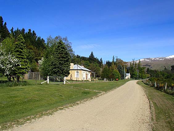
Current Description Setting Shepherds Creek has its origins in the Dunstan Mountains. It flows into a wide flat valley, bounded by terraces and low hills, before joining Dunstan Creek. The widest part of the valley is close to Vinegar Hill and is known as Vinegar Flat. Further down the creek, the floor is narrower, and this is known as Shepherds Hut Flat or Shepherds Flat. Lengths of Shepherds Creek were worked by sluicing. The setting is dramatic, with the Hawkdun and Dunstan Mountains both visible from the house. The cottage in its setting has aesthetic significance. Along Shepherds Creek were the residence areas where miners lived to work their claims. Survey plans show other residence areas dotted along Shepherds Flat Road, with the mining claims further up the valley – sluicing faces and water races visible on the hillsides. The cottage is set within an old residence area. The residence area is bounded by Shepherds Creek and Shepherds Flat Road. A water race runs along one side of the property. The residence area is marked by a line of mature trees, including poplars, referred to in the property’s current name ‘Lombardy Cottage’. The Cottage The cottage is typical of a nineteenth-century gold miner’s residence. It is built of local schist stone, single storey, with a central door flanked by two double-hung sash windows. It is small, probably only two-roomed originally. Photographs from the 1990s show a derelict building with a corrugated iron lean-to at the rear. The cottage has been altered – the partition walls have been removed, creating a largely open-plan space serving as living room and kitchen. The only remaining room within the original cottage is a study. The original coal range remains, as do the fireplaces. A corrugated iron addition to the rear of the cottage provides bedrooms and bathrooms. The scale of the addition is small, and the timber joinery matches that of the cottage. The original exterior wall of the cottage is exposed, clearly demarcating the original building. Although the cottage has been modified, in its setting, scale, and form, it still gives a sense of the original miner’s cottage, and the additions recognise the original materials and the vernacular of the area.
Current Description Setting Shepherds Creek has its origins in the Dunstan Mountains. It flows into a wide flat valley, bounded by terraces and low hills, before joining Dunstan Creek. The widest part of the valley is close to Vinegar Hill and is known as Vinegar Flat. Further down the creek, the floor is narrower, and this is known as Shepherds Hut Flat or Shepherds Flat. Lengths of Shepherds Creek were worked by sluicing. The setting is dramatic, with the Hawkdun and Dunstan Mountains both visible from the house. The cottage in its setting has aesthetic significance. Along Shepherds Creek were the residence areas where miners lived to work their claims. Survey plans show other residence areas dotted along Shepherds Flat Road, with the mining claims further up the valley – sluicing faces and water races visible on the hillsides. The cottage is set within an old residence area. The residence area is bounded by Shepherds Creek and Shepherds Flat Road. A water race runs along one side of the property. The residence area is marked by a line of mature trees, including poplars, referred to in the property’s current name ‘Lombardy Cottage’. The Cottage The cottage is typical of a nineteenth-century gold miner’s residence. It is built of local schist stone, single storey, with a central door flanked by two double-hung sash windows. It is small, probably only two-roomed originally. Photographs from the 1990s show a derelict building with a corrugated iron lean-to at the rear. The cottage has been altered – the partition walls have been removed, creating a largely open-plan space serving as living room and kitchen. The only remaining room within the original cottage is a study. The original coal range remains, as do the fireplaces. A corrugated iron addition to the rear of the cottage provides bedrooms and bathrooms. The scale of the addition is small, and the timber joinery matches that of the cottage. The original exterior wall of the cottage is exposed, clearly demarcating the original building. Although the cottage has been modified, in its setting, scale, and form, it still gives a sense of the original miner’s cottage, and the additions recognise the original materials and the vernacular of the area.
Historical and Associated Iwi / Hapū / Whānau
Completion Date
16th May 2017
Report Written By
Heather Bauchop
Information Sources
McCraw, 2009
John McCraw, The Gold Baron: John Ewing Central Otago’s mining entrepreneur, Central Stories Museum and Art Gallery, Alexandra, 2009
Middleton, 2012
Angela Middleton, ‘Vinegar Hill Gold Workings: Archaeological Assessment for Glass Earth Limited’, Arch Hill Heritage Report No. 85, March 2011, Heritage New Zealand file 2012-433
Morgan, 2001
T. Morgan, Welshman’s Gold Aur y Cymro: The Morgans of Cambrian and St. Bathans, T.L. Morgan, Alexandra, 2001
Other Information
A fully referenced New Zealand Heritage List report is available on request from Otago/Southland Area Office of Heritage New Zealand. Please note that entry on the New Zealand Heritage List/Rarangi Korero identifies only the heritage values of the property concerned, and should not be construed as advice on the state of the property, or as a comment of its soundness or safety, including in regard to earthquake risk, safety in the event of fire, or insanitary conditions.
Current Usages
Uses: Accommodation
Specific Usage: House
Uses: Commemoration
Specific Usage: Accommodation House
Former Usages
General Usage: Accommodation
Specific Usage: House
Web Links
description: Lombardy Cottage website
Current Usages
Uses: Accommodation
Specific Usage: House
Uses: Commemoration
Specific Usage: Accommodation House
Former Usages
General Usage: Accommodation
Specific Usage: House
Web Links
description: Lombardy Cottage website
Location
Related listings
Stay up to date with Heritage this month
